psuhoffman
-
Posts
26,285 -
Joined
-
Last visited
Content Type
Profiles
Blogs
Forums
American Weather
Media Demo
Store
Gallery
Everything posted by psuhoffman
-
But don’t almost all our snows not show on guidance at some point also? Take Jan 6th. That storm was modeled as rain 7+ days out and ended up a 6” snow for DC. We just don’t treat those the same because it’s what we want. Also keep in mind most of the time a rug pull here ends up snow somewhere else. Your rug pull Jan 19 was a snow for me and PA. Our rug pull now might end up a snow for Norfolk! The models aren’t “taking out snow away” they are shifting the track of storms which moves the snow area. Sometimes that helps us. Sometimes it hurts us. But maybe because of human nature we focus on the times it hurts us more. There are plenty of times we aren’t in the snow zone 100 hours out and get snow. BTW I’m not being derogatory, I know there have been some posts like that, don’t lump me in I’m just trying to have a respectful dialogue.
-
Something to consider. You are comparing a forecast to a model output. The NHC forecast you’re citing uses evidence and model output is one piece of that. But you’re comparing two very different things here aren’t you? One is a tool to help us get a final product and the other is the final product.
-
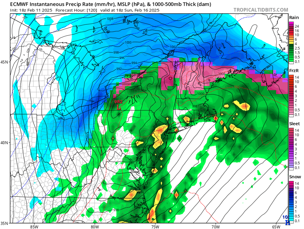
Honestly they both look like we should be worried about a too far NW track not a coastal scraper. I’ve honestly never need so “confused” by model output. I rarely ever see something I’ve never seen before but this is if. A closed h5 low near Chicago and a h7 pass through PA = big snow to our southeast? Not in any book I’ve ever read.
-
I was in VA at my brothers. Got 8 there. Then went to visit my sister and by the time I got home the snow was blown all over. I went of a neighbors estimate.
-
In fairness 100 Hours didn’t used to be “close in” I made that mistake because several storms recently the euro did a great job from 120 on in and I falsely applied that to this
-
Right but those waves had a flat suppressive flow over the top and no amplified cut off h5 low to their west to pump some ridging in front. I saw why those didn’t gain latitude. I don’t understand this one. BTW I’m not saying this should be a HECS it doesn’t really fit that either. The best comps I saw that surface and h5 match are kinda messy storms (like as in sometimes multiple waves or miller b) not the perfect bombs but they weren’t suppressed south of us.
-
The NAM is doing what I envisioned. Focused more on the TN valley wave along the arctic boundary. Just wish it was showing on the better models too.
-
2” here
-
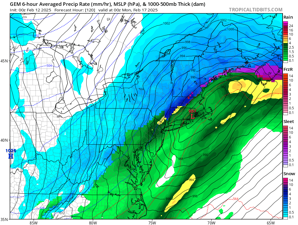
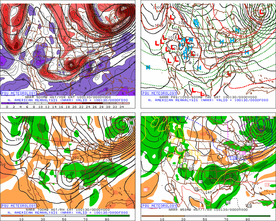
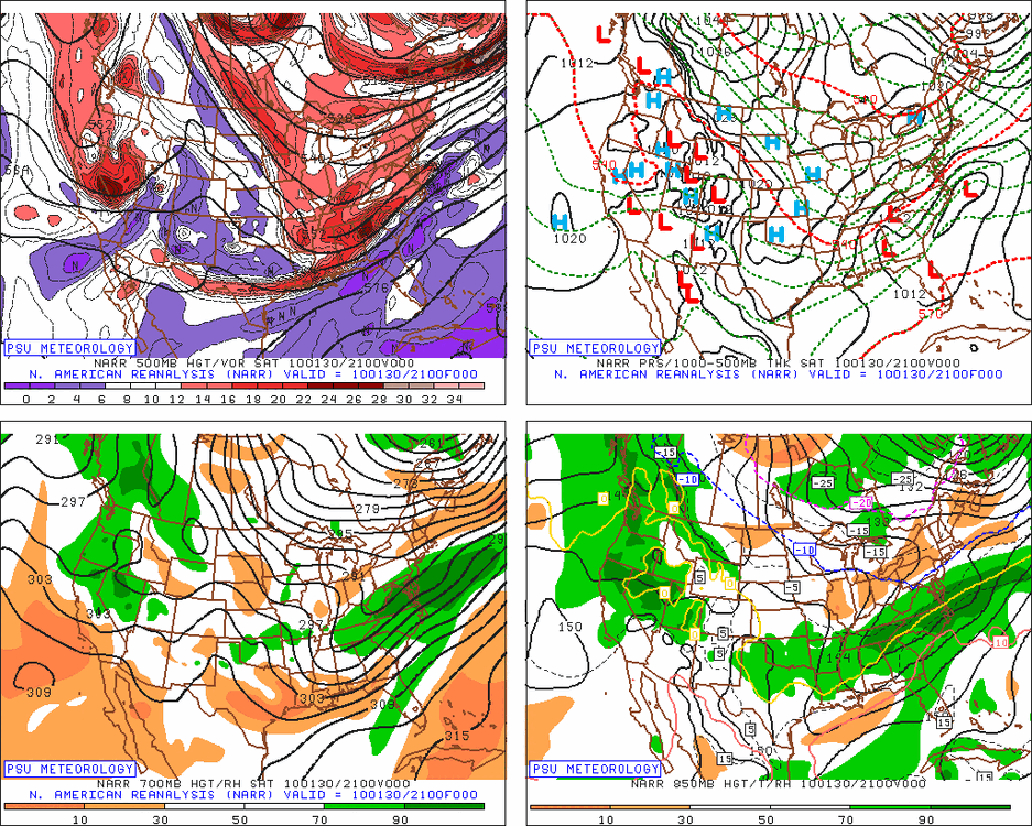
It’s a great match at the surface. But look how different it is at h5 and h7. Ignore the surface look at h5 and h7 the setup as the wave enters the TN valley 2010 now As the wave passes VA beach 2010 now
-
That actually makes more sense given the h5. Could see a double wave miller b type setup. At least I understand that. I hate being confused by guidance that doesn’t match anything I’ve ever seen before.
-
I need 18”
-
Also if everyone just on the PA side of the line up here goes up to the other forum myself and many of the northern MD contingent might follow because our climo is probably more similar to there and if we no longer have anyone in here to commiserate with or have our local meso discussions in a storm then it might make more sense to be with them. I’d probably end up splitting my time more. Right now the PA forum is more central PA and the right along the PA line people are in here with us.
-
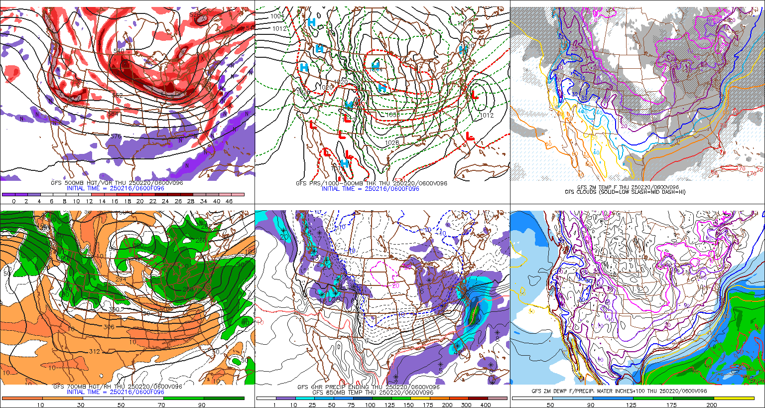
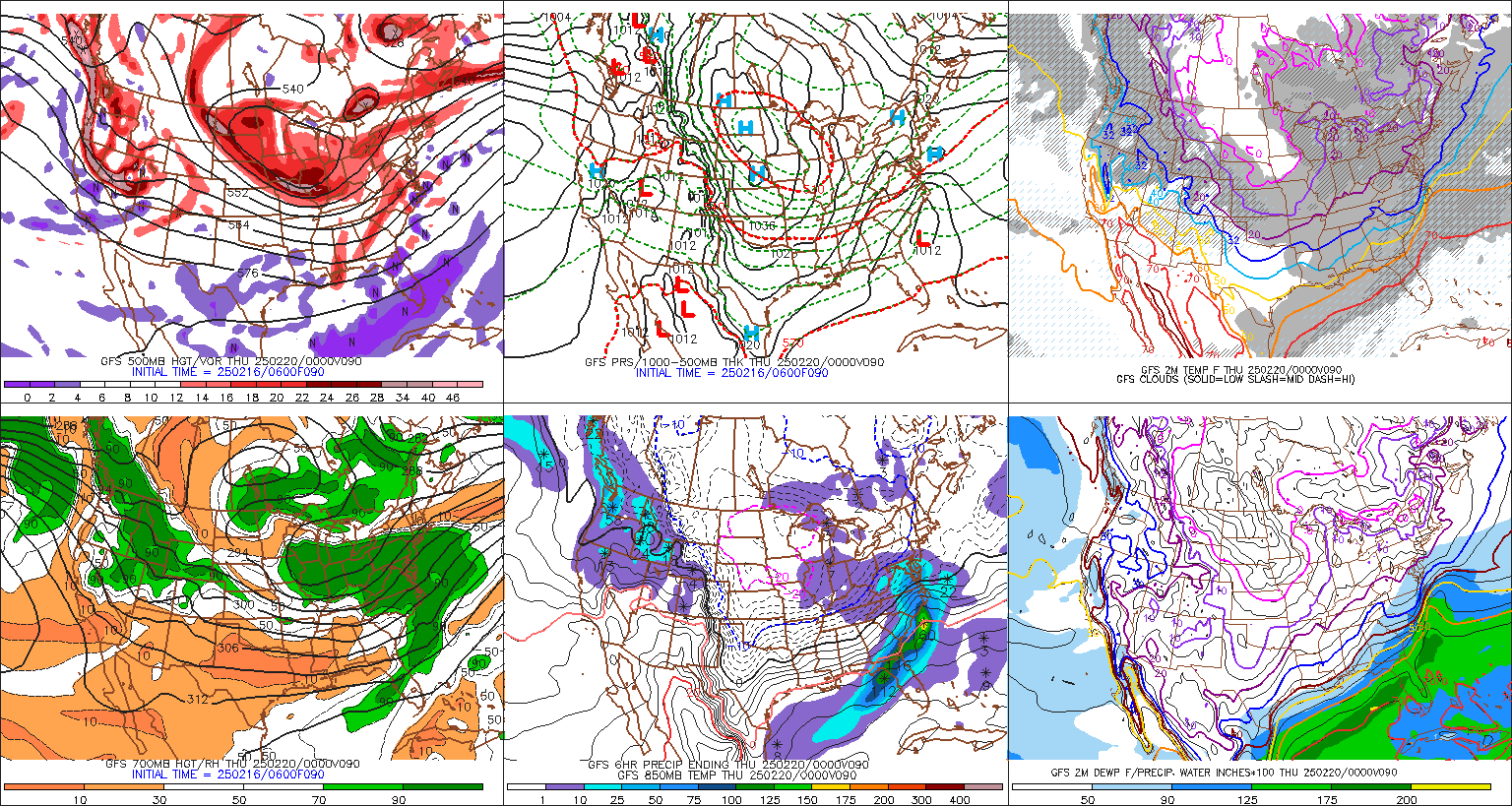
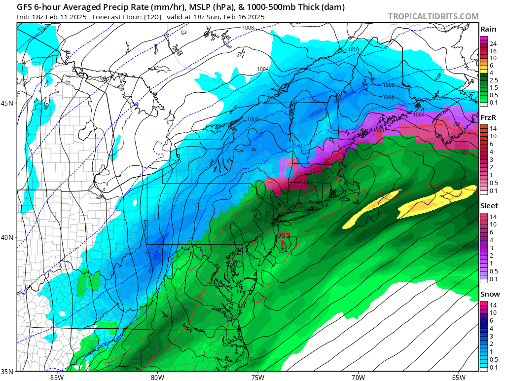
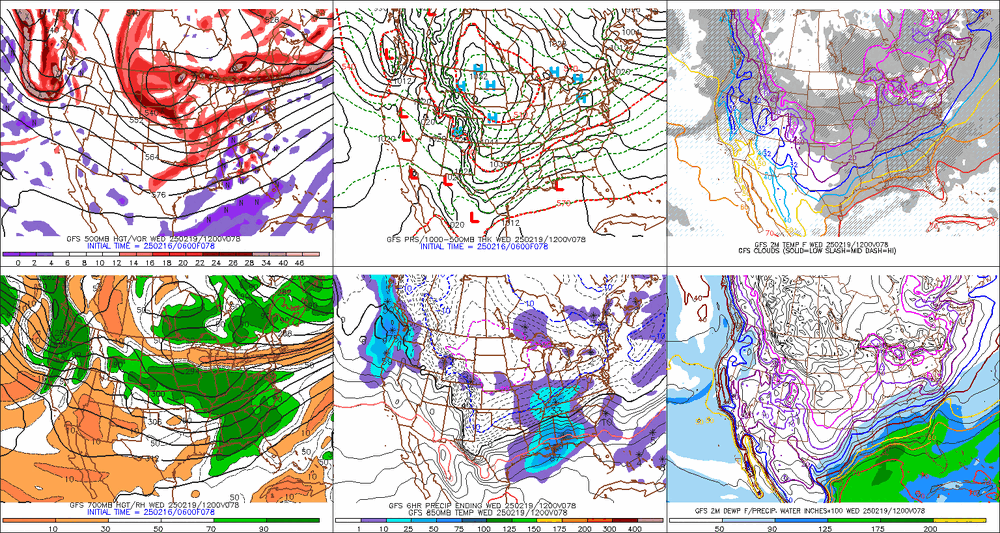
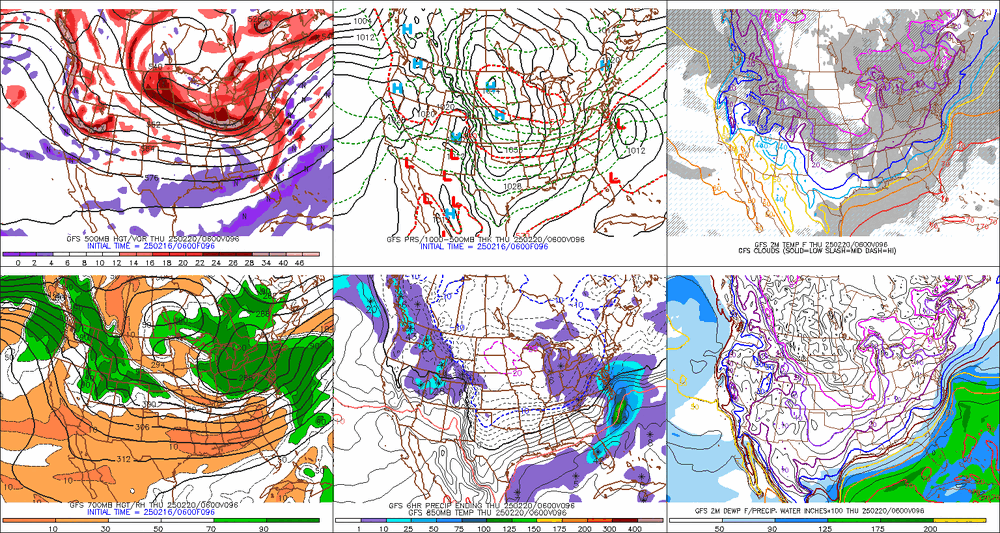
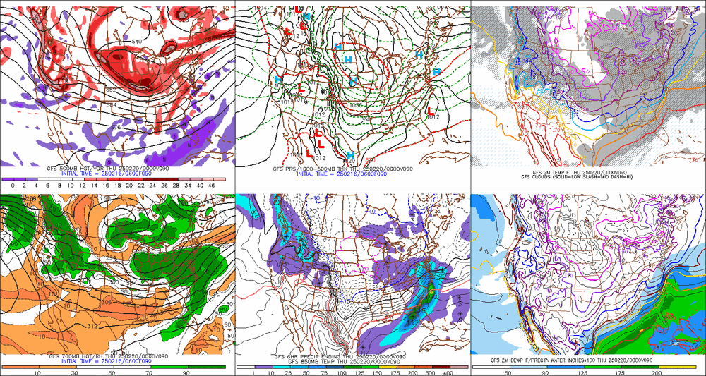
I’m gonna die on this hill, I went through every single analog on that list, most of them I’d already identified yesterday and looked at, and not a single is even close to the h5 look we have this week. They must be using the surface heavily to identify these. Again I’ll use the GFS, euro is even more amplified. now here are some new analogs on that list that were big snows to our southeast, but look at the h5 track, way south of this week and a way more suppressive look up top. The differences at h7 are even worse. I’ve never seen a snow for southeast Va with a h7 low over PA. Which brings me to the best example at the mid and upper levels to this week on that analog list it’s not a good match but I said “best” match. The h5 track is at least similar but way way less amplifies. The result was a weak wave south that didn’t really give anyone much snow. Thats a believable outcome. But I still cannot find a single example of a h5 and h7 setup even close to this week they resulted in a southeast VA or Delmarva snowstorm. I ran the composite for all 8” snows for Richmond and Salisbury and the h5 min anomaly was centered on Atlanta. This week it’s centered around KY. That doesn’t even match the DC snow comp best, it’s the closest to the NYC storm comp. Something has to give here. Unless we really are going to see something that’s never happened before I see 3 possibilities. From least to most likely. 1) the guidance is going to adjust at h5/h7 way way south with those features (from a OH to PA pass to a KY to southern VA pass) and then a big snow centered down there makes sense. This is really unlikely given the degree of chance that requires. 2) Guidance is going to trend significantly de-amplified at H5 and there will be a more modest snowstorm to the southeast. This is slightly more possible. If the h5 ends up stretched out and not closed off up top a weaker but not totally insignificant wave can slide east under it and drop a 6-12” type snow to our south. That’s still a significant h5 change for this range but it as crazy as what’s needed to match the 10”+ southeast snow analogs 3) the surface adjusts. This is by far the most likely imo. The issue here is the surface could adjust in two ways. One it could adjust to a snow further north, like some of the ones on that analog list that actually do fit the h5 better. But I’m wondering given the seasonal trends and Nina of the most likely adjustment is for the surface to de-amplify into a weaker wave that becomes a minor (say 3-6”) type snow somewhere close to where the max is now. There are examples of very weak waves failing to get “captured” by a similar h5 or simply being too weak to gain latitude in this type flow and then hitting places like SE VA. So if this were to adjust weaker then the surface track makes sense What I can’t see is the mid and upper level pattern projected right now across guidance producing a 12”+ snow for SE VA or the Delmarva. Just like we look at the pattern comps for us to identify when that kind of storm is coming, this doesn’t fit the pattern comps for a big snow there. It’s not even close.
-
99% of the time the most extreme model in either direction won’t 100% “win” it will end up a compromise. Even the event today I used as an example of a euro v all win, the euro was “slightly” over amped and while it was a huge win it did come maybe 10% while all others came 90%. So when the most east models come west a little bit it doesn’t mean it’s a west trend across all guidance or that the more west models will also go west. It’s more likely just convergence happening.
-
I agree with your point about a flatter wave possibly, but my main point is I looked through trying to find any examples of a significant snow to miss us to the southeast like that from a closed H5 low tracking through OH and southern PA like all guidance has...and couldn't. Every snow to miss us southeast like that had a much further south H5 track and a more suppressive flow over the top. So...either this trends way weaker and misses south, or it probably has to come north if its anywhere close to as amplified a wave as guidance has now, because the upper flow is not right for a big southern VA snowstorm. Its either a weak washed out wave that slides south, or if its amplified enough to be a big snow it will end up further north.
-
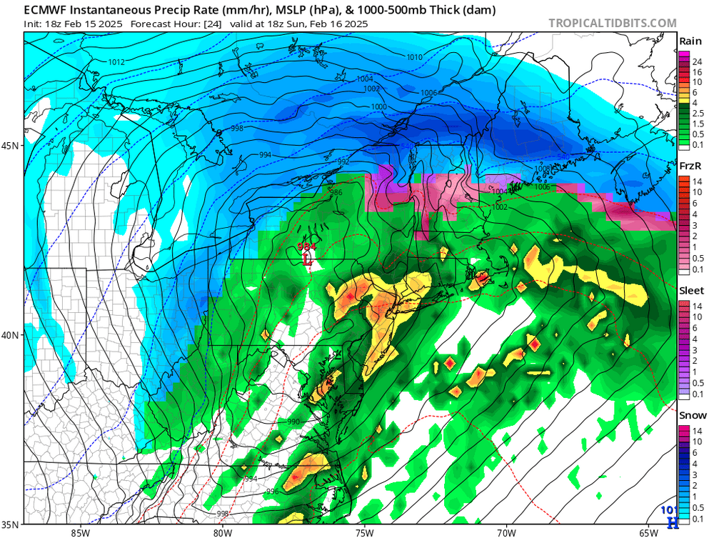
wrt euro v all others...actually it ended up being 2mb and maybe 20 miles off on is SLP placement from 120 v what it shows now at 24 hours and has the precip almost exactly where it is. It pretty much nailed the storm from 120 while literally everything else, including the AI, was over 100 miles off.
-
@Terpeast Euro might have been slightly over amped in the end though, which is not good considering we need it to win 100%, but from 120 it was way way closer than everything else Euro at 120 All others Current Forecast


-
It kinda did up in New England this week. I was watching because there was a chance I was going up there to ski this weekend with the kids. Earlier this week there was a point when the IKON, AI, GGEM and GFS were all showing snow with a track closer to the coast. The Euro was more amped and NW with freezing rain and sleet getting all the way into northern VT. Eventually all the other guidance came around. Oddly after it did they then had a couple runs where they would go back to a SE solution before coming back NW again. Looks like the Euro had the right idea. But this is just one example...and a different setup. Usually when the euro is totally on its own its wrong, but over the years its more right in that setup than any of the others.
-
ok but no one has been able to answer me this...models are showing a big snow to our SE, why can't I find a single example of a big snow for SE VA with a H5 low crossing OH and PA? Every miss to our south like that has an H5 crossing VA or NC not to our north. What am I missing?
-
Ugh now guidance is trending towards a believable south fail. A weak wave that’s not a big snow for anyone. I just didn’t think that’s where it was heading. Even the misses were clobbering SE of us. But if it ends up a weaker system with no significant 8”+ snow anywhere that actually makes more sense.
-
Looping to 81 hrs it has the look of incoming not gonna miss. Tn valley wave is healthy and all. I don’t buy they it just dies coming east with a non suppressive flow.
-
Most…it was ALL
-
True but if it goes down that way imma need an explanation why for 3 straight runs every op was NW of their ensembles. Significantly so. It was too many runs consistently for it to have been a random fluke of the ops spitting out an outlier.
-
just shoot me
-
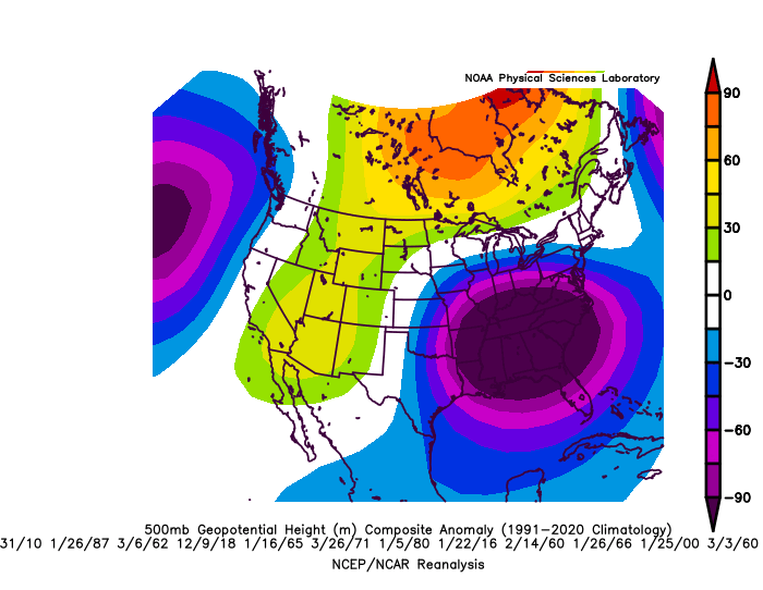
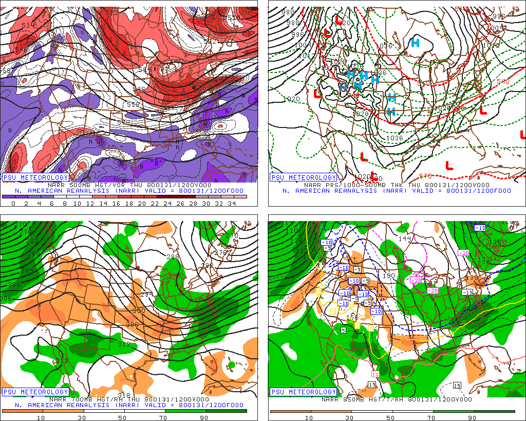
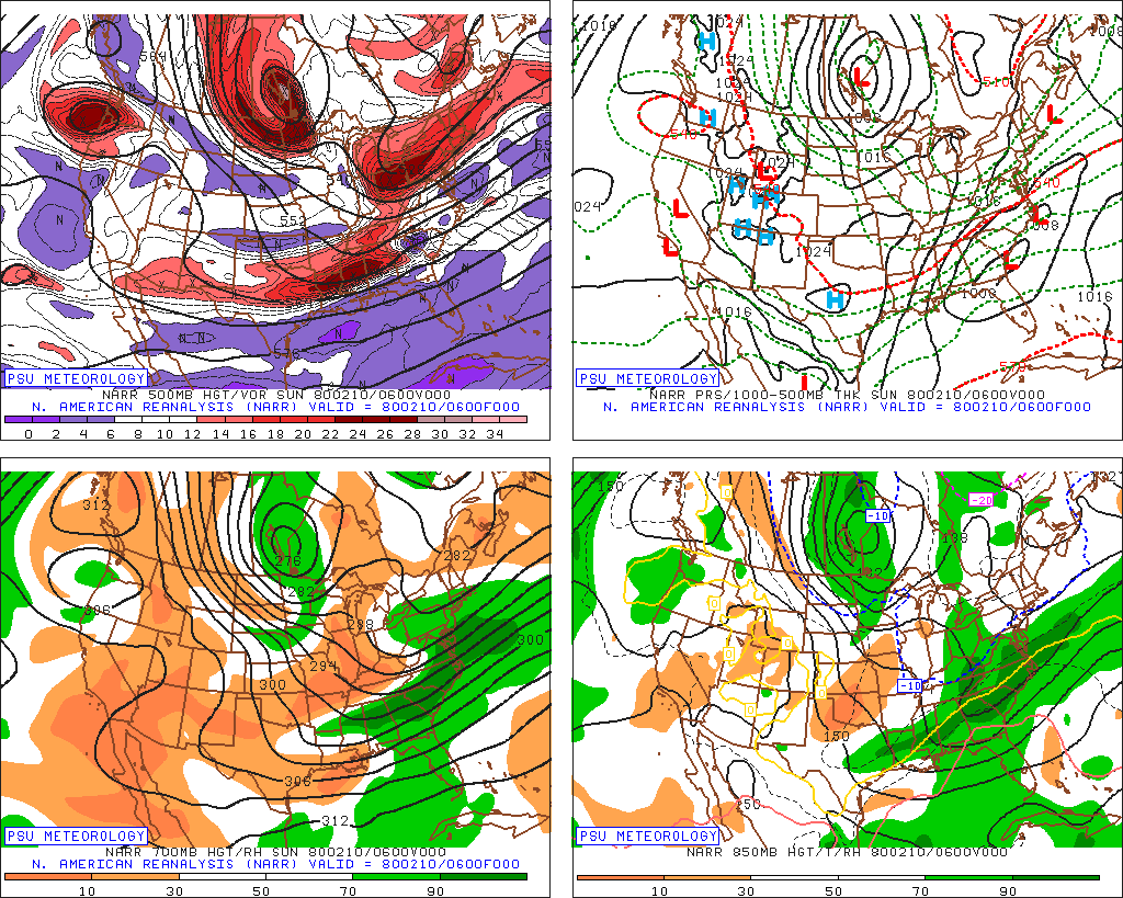
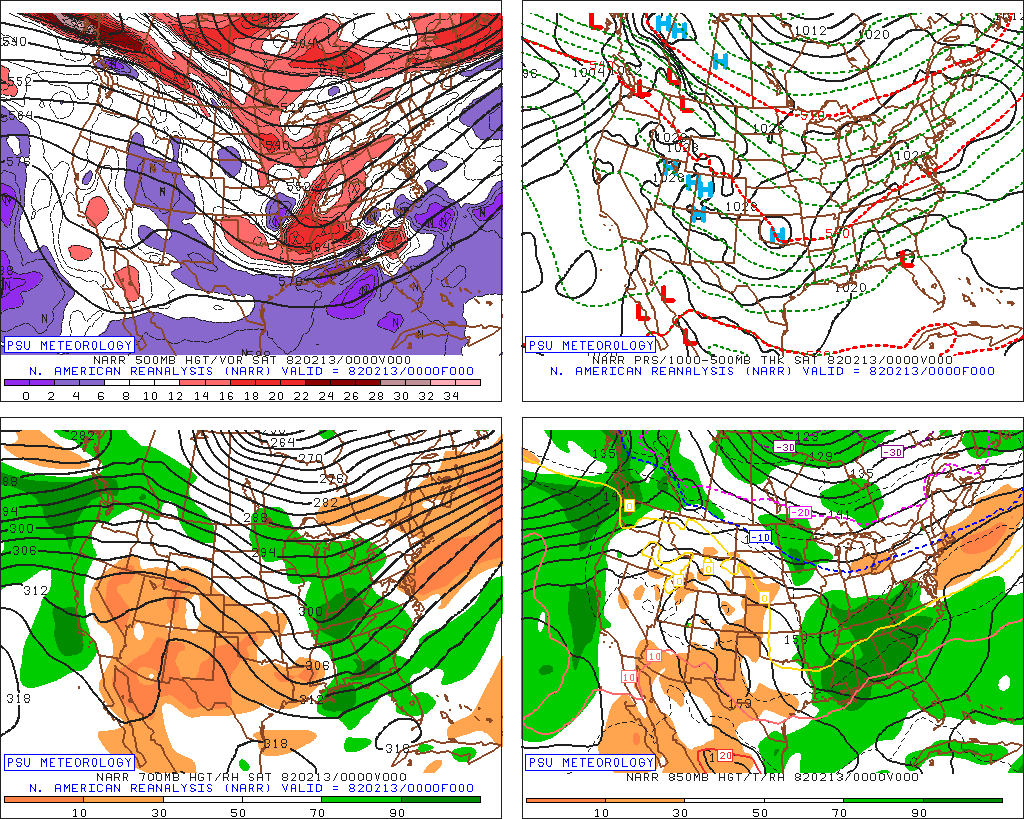
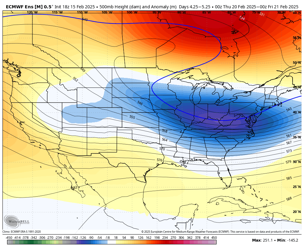
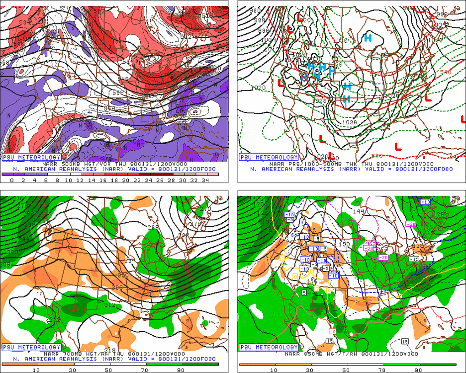
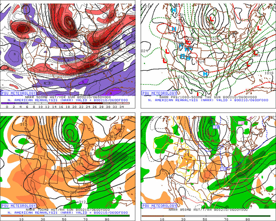
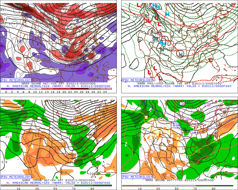
This is the composite 1 day mean h5 anomaly of all Richmond 8" snowstorms since 1950. Note where the mean anomaly is centered. This is the EPS 1 day anomaly for our storm