

psuhoffman
-
Posts
26,285 -
Joined
-
Last visited
Content Type
Profiles
Blogs
Forums
American Weather
Media Demo
Store
Gallery
Everything posted by psuhoffman
-
I would agree with this for EVERY other team in the NFL except KC. If the Ravens get the Chiefs (and I think they will) in the AFC championship that is the only time snow would likely advantage the Ravens. KC is equally reliant on speed and skill position players but its more reliant on that wrt their passing game. Baltimore is way more able to lean on their run game and win that type of game then KC is imo.
-
Some recent studies suggest the genesis of this might lay with what is going on to the SW of the enso regions though. Not sure it would really change that equation much. During a strong enso event that signal could overpower this phenomenon for a while, but after it might just revert if the cause is from the IO and waters near Australia.
-
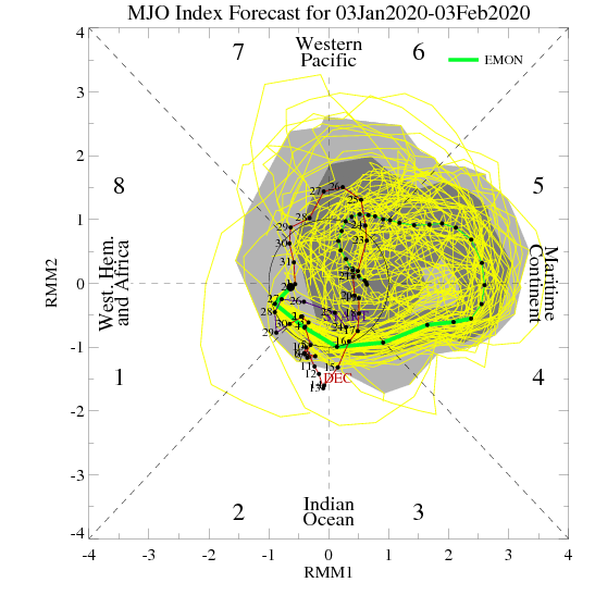
I think whether we salvage a decent winter pattern sometime the second half depends on what the MJO does. Right now the surge into a high amplitude MC wave is feeding the central pac ridge. What happens late January into Feb depends on what happens with that wave. The long range euro implies it dies then recycles back towards the warm phases in early Feb. That would probably kill winter. We might get a transient shot at something during the week the MJO wave relaxes but by the time any decent pattern could establish the wave would be surging back into warm phases, pumping the pac ridge and its winter over at that point..being early Feb and about to recycle right back where we are now. That is the 2002/2008/2012 option. And the still warming water near the MC really bothers me because it gives credibility to that possibility. If the MJO can survive into phase 8/1/2/3 then we will likely see things evolve better. I do see signs that the Atlantic wants to help, but the current mjo state is going to fight that off. The pacific will defy any wave breaking attempts from the atlantic so long as we have a high amplitude phase 4/5/6. If we can get an appreciable period either without MJO influence, or better cold phase influence I do think the atlantic will be able to bully the pattern in our favor. Last nights euro run trended more favorably wrt the mjo progression. Ironically, and its why the GFS backed off on its colder look from yesterday, the GEFS flipped places with the EPS and now shows the MJO cycling in the warm phases with no end in sight. I think how this resolves is the key to our prospects for improvement. If we see the MJO trend towards a workable look in a week or so we might be ok. If we see it start to show signs of wanting to recycle (basically a standing wave in the MC) in the warm phases all winter we are in big big trouble. Just another MJO thought (maybe someone above my pay grade can answer this) but I was thinking about how the warm phases have a much higher correlation to temps here than the cold phases. I wonder how much of that is because the warm phases directly impact the pacific ridge amplitude/location but there are two cold phase locations. The phase 8/1 out near the dateline would more directly impact our pattern by forcing the ridge east into the EPO/PNA domain, where the cold phase waves off Africa would only indirectly do that by placing a ridge in a favorable location in Asia to way downstream effect North America but there is way more that can disrupt that between there and here. I wonder if we only looked at MJO forcing near the dateline if it would have a higher correlation (similar to the MC forcing) than when we include all cold phases, some of which are from the Indian Ocean forcing. Maybe someone out there knows, I've not seen any study on this. I am not saying I think that will have much bearing on our outcome. There is a more favorable SST to IO forcing vs Dateline. Unfortunately the waters near the dateline in the PAC are cooling...not what we want. But I think there are enough signs the atlantic wants to help that if we can just get the MJO out of the "killing us" phases, even if its the less favorable IO forcing it would be enough. At least I hope.
-
It's not right/wrong...shift the ridge into an EPO ridge WITH AO blocking and that is a very good look. I was just pointing out that the comps to this pattern say that is NOT the most likely outcome. Looking at EVERY example of a similar comp pattern NONE went on to get better without blocking. NONE. That isn't a forecast...its just me pointing out that I can't find any examples of a pattern like the one we are in that improved without some help from a -AO/NAO. So I am not holding my breath on that. Secondly...in the examples that did improve, it was way more common that the blocking over the top forced the pac ridge to retrograde (at least in the mid latitudes) not progress. If that ridge did progress into the epo and link up with an AO ridge that is totally fine, just saying the numbers don't support that to be as likely as AO ridging forcing a retrogression in the PAC.
-
It's what makes you good at what you do though!!!
-
No 40 would probably made more sense. Or I should have labeled or specified it. My bad.
-
It wasn’t meant to be 40. I was roughly paralleling DCs Lat. but I did it real quick so it might be a little off. Sorry. The point though is latitude matters more than longitude other than where elevation and water comes into play.
-
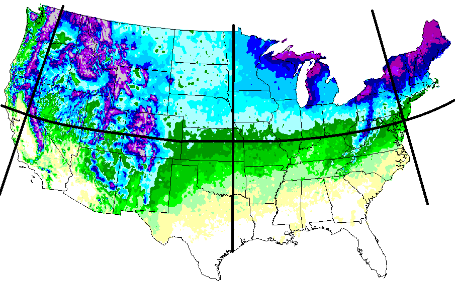
wrt snow climo... if you account for the curvature of the map and line up our general latitude, then account for elevation and bodies of water...you can see that mean snowfall runs mostly parallel to the latitude. Obviously you have to account for the influence of the Pacific and Atlantic and the Rockies and Apps. Plus when I say we are too far south...and people counter with Philly or NYC...they are just as much if not more east than north. If we were NORTH at NYC latitude we would be in central PA NOT NYC. It isnt fair to put us right on the Atlantic Ocean at sea level and then say "see its not that much more snow".
-
I agree with your sentiments wrt our snowfall climo. I think we remember the times other places get hit and we dont...but tend to forget the times we get snow and they do not...(it does happen) and times we both get screwed together. There is some bias there. But... comparing IAD to Philly isnt really a fair comp though. PHL is at 36' right on the Delaware rive in the coastal plainr. IAD is at 313' west of the fall line. DCA is a better regional comp to PHL. You have to account for elevation and water. A better comp to IAD in the philly area is West Chester which averages 26.5". So there is a bit more difference between DC/PHL/NYC than you are making it seem when you use IAD as a comp to urban locations at sea level in those other two cities. But it's also not as great as some like Mdecoy make it seem.
-
I agree with this. Some seem to be rooting for progression of the pac ridge...and that would be "better" but almost anything is better. It still wouldn't be a very snowy look unless it were to severely shift and a trough build in the central pac. That is asking a lot, and not much historical support for that drastic a pac pattern flip during one season. Plus...looking at some examples that worked with an epo ridge it took other factors to line up, and even that isnt all that common. 2014 we had a cooperative AO most of the winter. 2015 we got lucky with a displaced TPV in Quebec that suppressed the flow. Without that it wouldn't have worked. 90% of the time an epo ridge with a +NAM state is a good pattern to our NW and mostly a frustrating one here. The last example was the first week of Feb 2017. It looked epic from long range and then turned into cold rain and waves to our north all week. The better way to go if we want legit snow threats is to retrograde the pac ridge with some blocking over the top. Luckily the ensembles, which I trust more than the CFS, are hinting at that direction. That is where I am putting my chips.
-
Take this for what it’s worth, but history suggests we want regression not progression. First among the years with a period of similar pac ridge +AO regimes it’s very hard to find any that improved dramatically from progression of the pac absent AO or NAO help. There are a scattering of comps that lead to better patterns though from a NAM state flip causing retrogression of the PAC pattern. Get the pac ridge west a little so it stops digging the trough out west as sharp and pumping the eastern ridge. Then with blocking that’s how you can get a broad flat full conus trough. That leads to a wave pattern we can win with. ETA: it’s ok if the pac ridge is building over the top in the epo domain. But it needs to back off in the mid latitudes out of the area just west of the pna domain.
-
If you look at a snowfall map of the CONUS there is a pretty obvious north south based variance to snowfall. The exception is where elevation and bodies of water influence the distribution. In our local meso climate both exert influence. Because of the warm waters along the coast and the fact we have mountains in our western zones it skews the snowfall gradient SW to NE locally. We also advantage from a dip south in snowfall east of the Apps due to CAD and increased moisture from the Gulf and Atlantic. So if you are looking at a meso scale level yes going west within our region helps almost as much as going north. But on a broader scale north is much more important. If you live on the west coast going East helps. I was referencing the broader issue not the meso scale one. Wrt NYC their long term avg is closer to 28”. They had a couple of historically bad decades that skewed their means lower for a while but since it’s been increasing again. 28 v 20 is a fairly significant difference. Plus keep in mind NYC is right on the coast. You go west into North Jersey and get off the waterfront and averages get into the mid 30s quick. Go a little north of NYC and you hit 40! Results between DC/Balt and NYC/Bos are skewed some because they are right on the coast and we are inland. A more accurate comp between their latitude and ours would be to compare NYC to Atlantic City or Cape May!
-
He would hate it. He might avg about the same and maybe see snow more often but almost all that snow would come 1-3” at a time. Anything other than pure miller A storms coming north up the coast like Jan 2000 would flip to rain absent a rare arctic airmass.
-
Not going to do them much good. By the time they build up their base the torch will come and obliterate it. Its likely going to be a very rough year for them. By the time we get consistent cold (if we do) its likely too late for them to recover. They might have a good second half but losing the front 1/2 of winter is a killer for them. And in years where it’s crappy early often people turn to other things or go out west and it impacts them later too. Just realistically it’s going to be a bad year for them. It happens. They are used to it. The resorts that do a good job managing their Capitol will survive so long as we don’t get multiple years like that strung together.
-
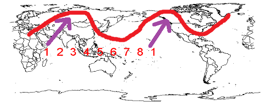
This is an oversimplification but as the heat released from the convective waves expand away from the equator (poleward) it is deflected to the right of its path by the coriolis effect. So basically... vs the cold phase convection locations the exact effect of the mjo wave phases change seasonally as the wavelengths and resistance to the heat release changes. But in winter that is the basic effect.
-
I do a lot better than DC. And I’m not complaining. But I’m not far enough north that I’m not susceptible to snow droughts also. But when it’s good it can get really good. And when the pattern is marginal it can be pretty good here. But the total fail suck fest patters aren’t much better here either. I’m not the frozen tundra or anything.
-
Draw a line west of the mountains and that’s about how much...and you wouldby like it. You would sacrifice a few small storms from west to east clippers for big totals where CAD saves us from a flip. Our best storms that track south of us have enough easterly wind component that the downslope isn’t an issue. It’s when we’re stuck in a pattern with lows going to our west that it sucks but that pattern wouldn’t be that good anyways.
-
I work in Baltimore. So I’m well aware. I often see it go from snowcover to nothing once I get into the city. From experience I don’t expect there to ever be much at work.
-
The climo thing is old. I get frustrated when we go stretches without snow and I get more of it so I don’t blame anyone for the frustration. So simply saying it has sucked is fine. When I go off on someone like Mdecoy or whatever he is going by now, it’s not for being frustrated, it’s for making up BS climo proclamations. It’s ok to feel like it sucks. But it’s not ok to pretend this isn’t normal. Truth is our climo sucks. Every once in a while we get lucky with a year or most recent a string of them when snow comes easy. The other 75% of the time is long stretches of nothingness with an occasional fluke storm or two mixed in if we’re lucky. Our base state is suck. We’re just far enough north that in a rare good pattern where the jet gets suppressed near our longitude we can get into the goods. The rest of the time we’re frustratingly too far south. Close enough to feel screwed when the storms go just north of us.
-
I thought it was a bad run.
-
How much did Baltimore city get March 21 2018?
-
It doesn’t look good but there are ways out. Those years were mostly Nina’s. If the NAM state flips the last week of Jan the mean pattern may look more like the non Nina analogs I posted. The new weeklies are a better look in Feb. not great. But they won’t be right exactly. If they are wrong and the trough is a bit more suppressed with a bit more ridging over the top it becomes a good look. If it’s the other way...not so much. Flip the coin.
-
Off hour run. Toss it. ...it is ugly though. Undoes all the improvement as goes right back to a neverending shutout look. But like I’ve said the gefs is more prove to run to run shifts. Unless it has multiple runs or the eps heads that way I’m not sweating it.
-
Like it matters he just tossed out a 12” storm as “barely counting”. Lol
-
I counted jan 2019....the rest are out of season and I dont remember dec 2017 I think it was Dec 9 2017. I had 6” up here. The cities only had 2” or so but I know not far NW had 3-5”. I think IAD had 4. Maybe it missed lees burg.


