

psuhoffman
-
Posts
26,285 -
Joined
-
Last visited
Content Type
Profiles
Blogs
Forums
American Weather
Media Demo
Store
Gallery
Everything posted by psuhoffman
-
I’m trying to be optimistic about the eps. But the danger if the NAM stays super positive and pac ridge relaxes but stays centered too far southwest once a trough pulls back into near AK ( which it would when the pac ridge relaxes) we would just transition to a zonal pac puke pattern. If we want a stable better pattern we either need AO/NAO help or an epo ridge. Absent either of those were rooting for luck with a perfectly timed transient feature like today. A ridge traverses the pna domain at the exact perfect time but even so it’s got limited potential and some will fail because of the overlying crap pattern. Who knows maybe we keep lucking our way to a decent year in an overall craptastic pattern but I don’t want to have to roll that way if we can avoid it.
-
It’s a convoluted look that has to be the result of higher than normal divergence. But there are features to like. The pac ridge relax and pressing into the west coast. Hints of a southern stream. Ridging west of Hudson. Still things not to like, the NAM. My take is the eps is unsure where to go which is better than some other options.
-
Know your climo, we spend 90% of our winter periods in “screwed”. It’s what we do best.
-
My fav too. Thanks.
-
Been raining in Baltimore but staring to change over. I’m leaving now to head home. Plan to take my son sledding.
-
I’ve noticed that it sometimes struggles with lighter precip at the start of an event and in those cases will default to surface temps. I don’t know if it takes a bit to calculate or if light precip is an issue for its algorithm but it does much better with heavier precip once an event gets going.
-
Not over yet...but not looking good. The UHI effect does seem to be getting worse in marginal situations...even faster then the general climo is degrading. There have been so many marginal historically 50/50 setups recently but they all seem to break wrong now.
-
Wife reports stickage at home, I am in Baltimore where it just started very light snow.
-
Overlooked? It’s all that’s been talked about for the urban corridor and why the forecast there is for less than NW.
-
The GEFS is even stronger into Phase 5/6 than the euro, but worse it starts to loop the wave back through warm phases with high amplitude in the long range. The euro simply kills the wave and lets "other factors" take the wheel. If the GEFS is actually right and the MJO stays in high amplitude and does a loopty loop in phases 4-6 were screwed. Lucky the GEFS been getting schooled by the EPS for a while now. Of course with our luck this will be the time the GEFS nails it.
-
Euro says DC area gets very heavy rates from 2-4pm. Inverted trough depiction still there south to north across central MD. Pretty good spot for Chill north to get some bonus.
-
This is my super secret early first estimate for a hypothetical guess. I will issue my first updated early estimated guess later today and my final forecast sometime tomorrow after I read the storm report bulletins. I actually feel pretty good about this one for anyone NW of 95... some pretty good forcing and omega showing up. Should overcome marginal temps there. I could even see some of those 3-4" totals sneak in real close to 95 if banding sets up right. In the UHI...it will be close and you know the drill. Good luck everyone.
-
Yea we're on the same page...but keep it out of the main threads... don't want to spoil their fun worrying about a degree or two the night before every event!
-
It happens somewhat frequently in marginal events. Especially NYC where being right on the coast can torch their boundary layer with an easterly wind.
-
Agreed, but the temp right at the surface hours before an event isn’t always a good indicator of the boundary layer during the storm. Due to an inversion it was 32 at my house but 28 a few hundred yards away down the mountain. So does that mean they will be 4 degrees colder during the storm? Actually the opposite.
-
I see you got your reaper check this morning.
-
I’ve been noticing that for a couple days. There seems to be a perfectly aligned weak IVT which is enhancing the FGEN and moisture convergence over our area for a time. Could add a little extra pop to the event for some that end up under those bands.
-
Is it cheating if I bought up all the remaining dip n dots and sprinkle them all over my yard before every storm?
-
What really matters is the thermal profile just above the surface and the dewpoints. I was lol at the posts obsessing over a couple degree difference in surface temps last night and this morning but didn’t want to spoil the fun in the main thread. Not sure if that wave slowed that much or it ended to the next one but what guidance nailed at impressive leads was that the pattern was loaded and any decent wave within that time period was likely to produce a big mid Atlantic storm.
-
Only if the fire pits have sharks with laser beams.
-
My earliest snow memories are waiting for busses in snow or listening to KYW and NJ 101.5. I got mad when they changed their jingle years ago because it reminded me of snow. 2 in particular, one of the 87 storms and one in 88 they waited way too long to let us go. The 88 one was supposed to be 1-3 changing to rain and even though there was already 3” and snowing hard when I got up they brought us in, then decided to send us home an hour later but it was too late. We got about 10” and we waited all day for the busses to get back then the bus ride took an hour to go a few miles. Good times. You’re welcome to stop at my homestead. Don’t know when I’ll be home though, depends on if BCPS closes early.
-
Depends...if it’s cold enough to build snowcover 4 5s. If not and it’s snow/melt cycle either 2 10s or a 20! Ideally I would split it into 3 storms. A 10”er to lay down some base followed by 2 5” storms. Or 8/6/6.
-
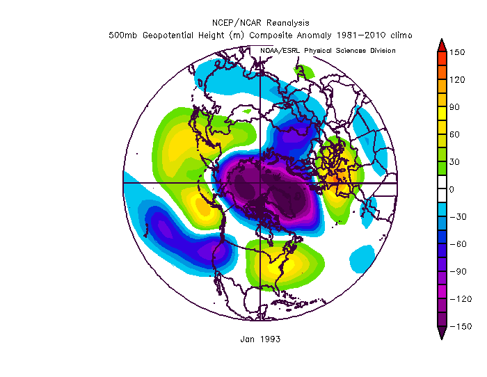
Depends what you consider “long term”. Most of the top analogs did lock in a long time. But there is no way I could pour through every week of every winter. I did look at every January. But a 10 day period can be masked within the monthly mean. But if the pattern locks in enough to show strongly on the monthly composite then no...all those examples it took blocking. Then there is this...since others have mentioned 1993 There are some significant differences in the pac near Hawaii and the location of the ridge so it didn’t show up as an analog but it’s similar in some ways. That year improved without blocking. But the snowy February was NW of the mid atl cities. And the one March storm was a crazy anomaly. A repeat of that pattern would be better but might not really make DC people happy. But it did get more of a trough in the east without blocking. But it wasn’t as good a match. So there is the issue of degrees. What is better? What is a good enough analog to include in the dataset. But a few things are clear from the analogs. 1. It’s a bad pattern. 2. It can last a long time (not always but it can) 3. If it locks in long enough to dominate a monthly mean it’s very likely to continue. 4. If it does without blocking were toast. That is all true but it leaves escape hatches. Maybe the pattern only lasts 10-15 days. If the pac ridge weakens or shifts into an epo ridge that opens non blocking options that might have not shown up. Or maybe we get blocking later in winter.
-
Yes but with the caveat that the pac ridge locked in for more than a short period. That feature is really starting to rage now but if the eps is right and it starts to wane in 12 days or so that takes us out of dire straights territory. If the eps long range is correct the January monthly mean won’t look like the bad composites as much. But if the pac ridge stays dominant then yes we would need blocking to offset. There are no good looks with a strong central pac ridge and a +AO/NAO Its still way out there though. And we would be better with blocking. The gradient pattern the cfs and eps is advertising can easily end up with most of the snow to our northwest if we don’t get lucky. Hate to say it but that look isn’t so good for your area. You would likely need more help. But it’s still a way better look than the raging pac ridge western trough combo.


