psuhoffman
-
Posts
27,419 -
Joined
-
Last visited
Content Type
Profiles
Blogs
Forums
American Weather
Media Demo
Store
Gallery
Everything posted by psuhoffman
-
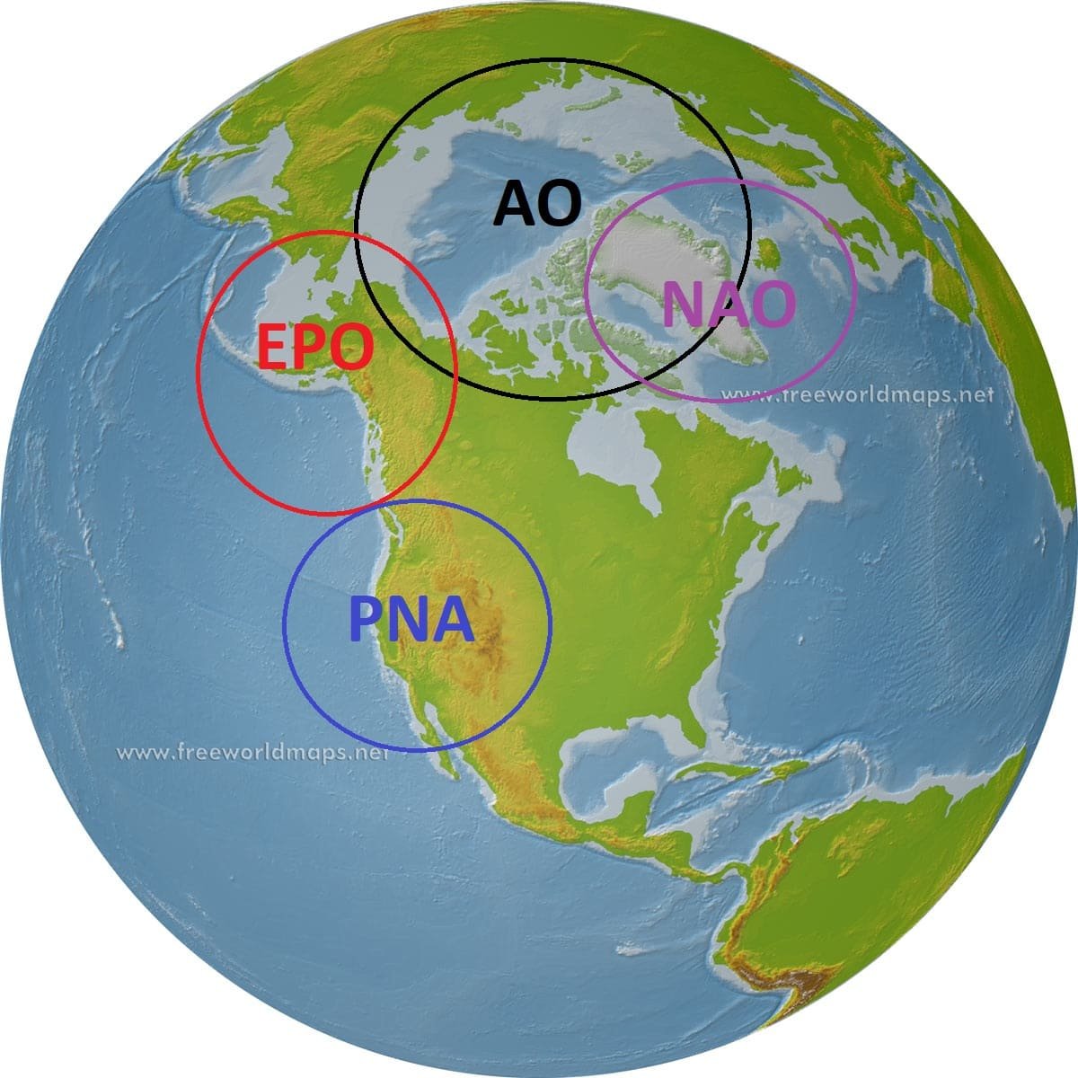
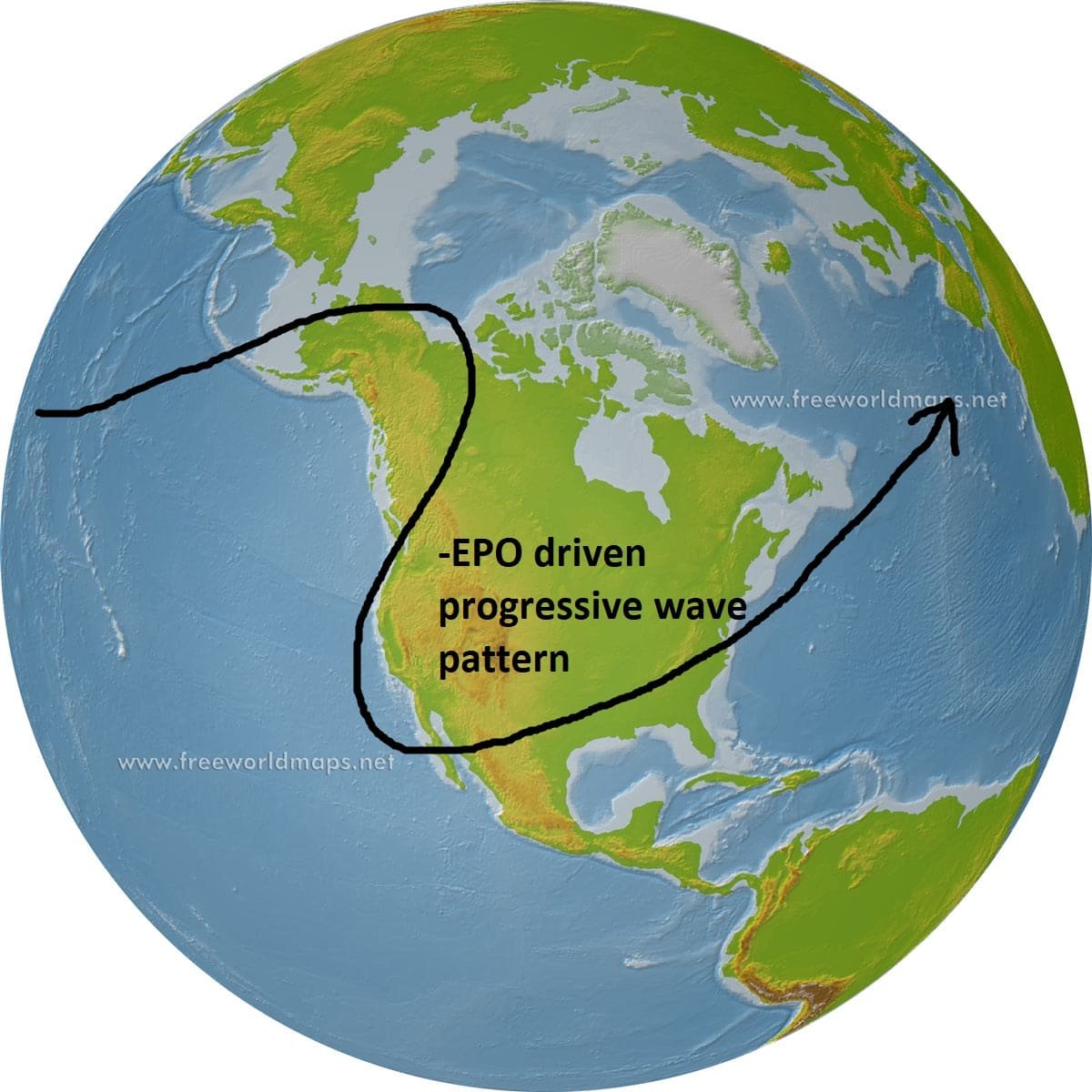
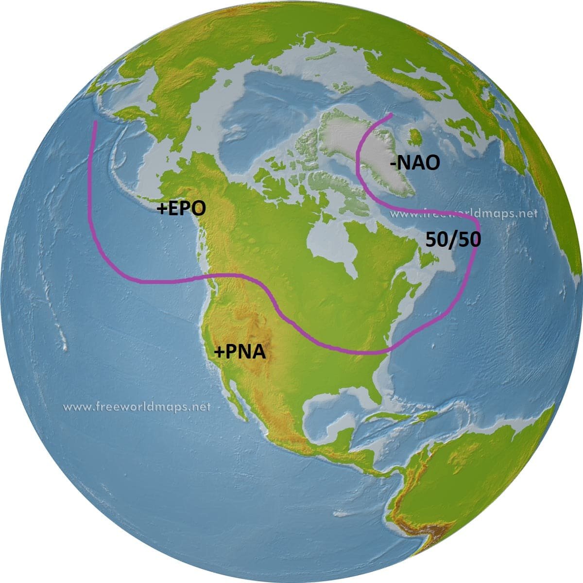
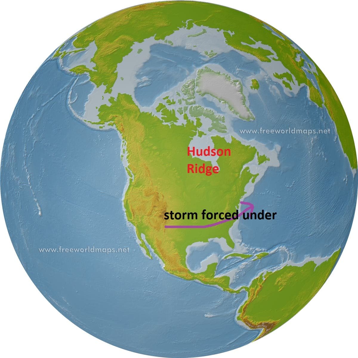
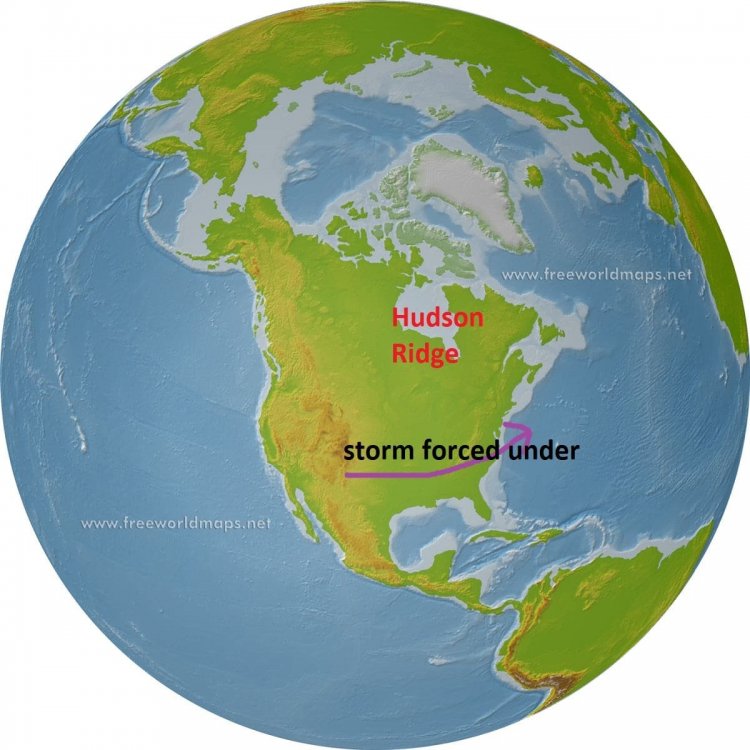
I have been seeing some of the same questions posted wrt patterns lately and been getting some PMs about it so I thought I would post some stuff I have been working on for a while wrt snow climo and patterns. Others can add to this also. I did a study of all warning level snowfall events at BWI going back to 1948 and I will post the results below but first I thought I would give some info. One disclaimer: most of this research and information is focused on warning criteria snowfalls. We can fluke our way to a minor advisory level event in almost any pattern during mid winter. It really muddies things if we include a lot of 1-3" type events. But there are clear patterns if we exclude minor events and only look at what patterns are right for 5"+ events. I am not dismissing minor snowfalls but its really hard to identify patterns for a 1-2" snowfall. Some common pattern driver indexes we reference The colder phase of these indexes are -EPO (ridge), +PNA (Ridge), -AO (weaker TPV over the pole), -NAO (ridging). But colder doesn't always equal snow. There is no one pattern for snow. The trick is getting the jet right so that we get a storm into our "box". The most common tracks to get a significant storm into that box are shown. But there are a variety of pattern combinations to get the jet wavelengths right. Changing one factor can change what we need from another. But the key is getting the jet aligned for the track of storms to end up just to out south or southeast. For example...most of us know about the idea -NAO pattern... But...a -EPO pattern can work too or a Hudson Bay Ridge I will go into specific patterns and what percentage of our warning criteria snowfalls came from those patterns in the next few posts


- 70 replies
-
- 20
-

-

-
My problem was obviously making my analysis before the eggnog not after.
-
On the other hand...if we assume we will not get any help from the NAO...this is the composite of all snowstorms since 1948 that featured an EPO ridge without NAO/AO help. Notice the location of the EPO ridge. It is VERY possible to get a snowstorm from the EPO alone...its actually only slightly below the NAO in terms of if we had to work with only one factor...HOWEVER that EPO ridge must be east based in NW Canada not out over the Pacific. So if we assume the AO/NAO do not improve we would need that ridge to end up significantly further east than projected currently.
-
If we get a dominant central Pac ridge pattern...there have been 10 January/February warning level snowfall events in our area with that regime, but every one had a pretty significant NAO block. This is the loading pattern a couple days before those 10 events. The point is for that ridge alignment to work would require an equally anomalous NAO block.
-
Most of us were on Eastern then. And I remember discussing the chances for snow late/Jan into Feb from well in advance. Yes there was a mild period but even then there were markers. The high latitudes remained conducive. And extreme blocking tends to recycle. I haven’t punted anything yet but I stand by what I said. If....We get to mid January and that pac pattern locks in with a raging positive AO were in big trouble. That look has NEVER ended well and it can be very persistent and hard to break out of. That look has accounted for some of our very worst winters like 2002 and 2012. Im not rooting for that. I want snow. But it’s hard to ignore what’s showing up in all guidance. Me saying that look sucks won’t change anything. Hopefully it never comes to that. There are ways out. Maybe the guidance is misplacing the ridge and it ends up creeping into NW Canada over the top. That’s an ok look. Or the NAO could flip suddenly. But we are flirting with what is the absolute worst look we could get for winter prospects on guidance right now imo. That’s based on all past seasons with a similar pattern. If me pointing that out bothers you...well sorry but not sorry .
-
I’m still not invested. My opinion isn’t changed by a couple day 9 op runs. There are very few decent snowstorms from the current pattern shown that period. There are a lot of very minor 1-2” type snows in that look. But it’s mostly a cold dry look that usually leads to suppressed sheared our waves followed by a warmup. Once in a while we get very lucky and I’ll root for that but at long leads climo beats op runs 90% of the time. As for your second point. I spent most of Nov and Dec very positive. I thought there were enough positive signs. In the past I have been very bullish. I have often pointed out looks I felt good about from really long range. Some hit. Some didn’t. But right now I see things I really don’t like. You can question my accuracy but at least my thought are authentic. If you want smoke blown up your arse I’m not the right one to look too. “if the guidance is right about the pac pattern pray the NAO flips or were toast.” I assume that is what you’re referencing. Sorry but that’s a factual statement. If that anomalous pac ridge is real and we don’t get some high latitude help history says we have almost no chance of snow of any consequence.
-
Yea me seeing where the pattern might be headed made it happen. Lol
-
Unless the Atlantic improves I fear that’s very likely what’s coming. That anomalous central pac ridge is on all guidance and it’s supported by the mjo progression and recent history (last year). I fear it’s likeky to be a reality. If so without NAO help that will lead to a huge ridge in the east. Last year we actually had just enough Atlantic help at times to prevent an all our SE ridge fest. If the AO/NAO stay positive and the pac ridge is real we will torch and it will likely last a long time. Im still working on the climo post. Family stuff came up yesterday. But I did finish the analysts of all warning level events going back to 1948. There are some Jan/Feb storms with a strong central pac ridge but they all had extreme NAO help. Not a single one had a ridge there with no NAO block. Reality is if the guidance is right about the pac pattern pray the NAO flips or were toast. Ironically I know people are rooting for that pac ridge to shift east but our better chance according to the pattern analogs is for Atlantic blocking to help retrograde that ridge a bit. It would put a trough into AK and cut off any chance of really cold air but also split the jet out west and let the stj cut under which would give us a fighting chance at snow. There were a few March events with a pac ridge absent NAO help once wavelengths shorten and funky stuff can happen. But it’s a shutout look in Jan Feb. Possibly the worst one there is.
-
I have to agree with that assessment. That’s why I’m stuck on the NAO. Every analog to what we are seeing so far this winter failed to develop into a favorable PNA pattern that winter. Those that did not get NAO help were utter disaster fail years. Those that got “some” NAO help salvaged respectable but still blah totals. A few got excellent blocking periods and had a very snowy period later in winter. Our fate rests in the Atlantic being able to offset the central pac ridge pna trough imo.
-
Looking at all the New Years period comps to this pattern that’s the only realistic save. It wasn’t all bad. Some (about 1/3) of the analogs to this current mess were in went on to a snowy period sometime later in winter. But they all did it the way you described. With an Atlantic ridge that retrogrades forcing the pac jet to split and cut under. I know some are rooting for that pac ridge to shift east (and that would work) but that’s not the most likely way we evolve to a better look according to the analogs.
-
It looks good through day 12 then reverts to this bwfore that there was a significant improvement with several big hits and numerous small ones in the day 10-13 range. I am hesitant though because it’s got the kind of gradient look that teases us day 10 only to become congrats upper Midwest and New England come game time. But the look at the end has a silver lining. The tpv is vacating Greenland and it’s easy to envision ridging building into the NAO space after that given the evolution day 13-15. Honestly imo that’s our best chance at a sustained favorable pattern. Imo the pac has shown it’s cards and frankly it’s a similar pattern to last year. The wpo/epo ridge is likely to remain a bit west of where we need it absent any blocking. But the qbo is more favorable this year so if we can a period of NAO help that pac becomes workable. I’m hopeful we see signs of the next -NAM period showing soon.
-
12z GEFS really degraded our snow chances day 10-15. Lost the eastern Canada ridging idea. It’s building a better Atlantic pattern way out at day 16 but it pushed the process back 5 days, back to fantasy range again. Perhaps it’s the right idea but was rushing it but until I see the eps move that way I am skeptical. EPS has been crushing the GEFS lately.
-
EPS is less enthusiastic but it did take a baby step away from the ledge imo. Slightly better ridging into AK. Some hints at improvement on the Atlantic side.
-
First let me clarify the point I was making based on history 1. If we get a strong central pac ridge the first half of Jan, that is highly likely to persist most of winter. 2. That pattern can only work if we get blocking 3. If signs of blocking don’t show up by mid January it’s highly unlikely things improve. History suggests years where blocking helped it showed up by mid January. So while im not punting anything now, if we get to say January 10th and we’ve been in a persistent central pac ridge +AO/NAO regime and guidance shows no light at the end of the tunnel then at that point yes I would say shut out the lights wrt realistic hope this season ends well. Still could get a fluke storm but chances of hitting climo would be extremely slim. What is my confidence that is what happens... 2/5 maybe. My gut still says this shouldn’t be a dumpster fire year. Historically enso neutral years with our qbo and north pac sst profile have been decent to good. There were some hints of a way out of that fate on guidance today. On the other hand climate changes may have rendered the analogs useless. Enso neutral years have been skewing less snowy lately. And I can’t ignore the evidence right in front of me wrt the pac pattern and the long term lack of blocking. I won’t pretend I’m not a lot less optimistic now than 2 weeks ago. So I guess right now I’m just waiting to see what the next 2 weeks shows this winter to be with an open mind. But unlike years when I argued we could easily pull a late save, history suggests the pattern guidance has been showing lately is not the kind of thing we recover from if that sets in for any appreciable amount of time.
-
That’s literally our only realistic way to salvage the pac look this year.
-
Why can’t there be analysis without some people exaggerating it to extremes. Good or bad. When someone says the pattern looks good suddenly they promised a blizzard. When someone says it looks bad suddenly they cancelled winter. Nobody punted January today. I’m glad HM is optimistic. But he also thought it would snow around the holidays. He did nail the -AO period but he missed the pac muting it’s impact. He also missed the AO then going positive again before the pac relaxed. No one is perfect. I say that because the only thing people said, including myself, was that if (somehow everyone misses the if) we get a prolonged central pac ridge with +AO/NAO pattern that’s a really bad sign for winter. And guess what it is. Doesn’t mean we will. Long range guidance is wrong a lot. But if 15 days from now we’re dealing with that look, HM is probably wrong and this winter is toast. But im not against him. I want it to snow. I hope he is right! But seeing a huge central pac ridge and +AO develop as we head into January isnt a good thing. Anyone who thinks that’s no big deal is kidding themselves. But we still have a long way to go before it’s time to give up.
-
@Bob Chill it’s a convoluted way to do it but the gefs manages a good look by building just enough ridging in eastern Canada to act as a bootleg block. The other key is this run backed off on the pac ridge just enough to allow the pv to pull back and allow that ridging. The changes were subtle but all in the right way to bootleg our way out of the disaster scenario. Fantasy land though. But I suppose looks like that show there is a way to avoid the doomsday look I posted earlier today! ETA: you ninja’d me
-
It’s over Greenland. I have used TT, USModels, wxbell at various times.
-
There are some hints in the long range the PV might retreat across the pole. That’s far from ideal and would limit cold potential BUT it would allow ridging across Canada and I would take that wrt snowfall mid winter than the pac ridge raging +AO combo.
-
I was thinking “if that warm water really is driving that what happens when it finally freezes over”. Well....
-
@Bob Chill There are some signs the NAO could be starting to flip again out towards day 15. Way too far out to buy anything but it’s hope at least.
-
@WEATHER53 and im not crapping on old school methodology. A sound understanding of the basics is a good foundation. But there is a reason we progressed. It’s amaxing what old timers were able to do but truth is accuracy sucked before NWP. There were huge busts at very short leads regularly. And forget even trying to nail a pattern from 2-3 weeks out. They had a hard enough time with 2-3 days. Now I’m not blasting them. They were severely limited in what they could do. Sorry but the human brain can’t possibbly handle all the variables that influence the atmosphere at long leads. So I’m not even sure what you are advocating! That we go back to pre NWP methodology when there was often no advance warning for major weather events?
-
Your timing is lol. The EPS has been killing the pattern at range for a while now. Absolutely nailed the current pattern from weeks out. Frankly the climate models nailed the look from months out. And wrt discreet synoptic features they have been good inside 72 hours when they should be. We’ve had no major surprises or model busts. But don’t mind me, just continue chasing windmills.
-
Good catch. We’re going to need some help on that side so that’s definitely something to watch. Tbh seeing the Atlantic side collapse really bothered me more than when we saw the pac turn a couple weeks ago. Once we got into December and the pac pattern started to show hints the analogs I was looking at suggested if we had a good winter it would be Atlantic not pacific driven. My vision (and it matches enough of the pattern analogs a week ago) was as the season progressed the Atlantic would assert more influence and block up the flow enough to cause a split jet and allow the pac trough to cut under. But I was aware there were also some comp years where the NAO broke down and those went on to be not so good. So seeing the breakdown of the AO/NAO regime was more troublesome as it made those years clearly more similar. I think if were going to make this work it’s going to have to come from some help up top or a lot of luck with a transient Atlantic feature.
-
The problems in 97 were an atrocious AO/NAO. The Pac wasn’t perfect but it wasn’t the main problem.