psuhoffman
-
Posts
26,285 -
Joined
-
Last visited
Content Type
Profiles
Blogs
Forums
American Weather
Media Demo
Store
Gallery
Everything posted by psuhoffman
-
The Euro has a sharper trough at the surface and mid levels and this creates a compact system as opposed to the GFS which has a more broad trough which directs more mid level winds (hence WAA) east into the mid atlantic vs the euro. In essense the GFS (and GGEM) have a frontrunner wave and the euro does not. At the surface the GFS is actually further north than the euro and warmer. The euro is colder and less amplified with the surface system BUT you can see from the isobars that there is no energy being directed east into the cold air compared to the gfs at 12z Saturday. Hence the lack of WAA precip extending east. Euro GFS It's a lot easier to see at the mid levels H7 heights and winds Look how the trough and winds are oriented on the euro GFS
-
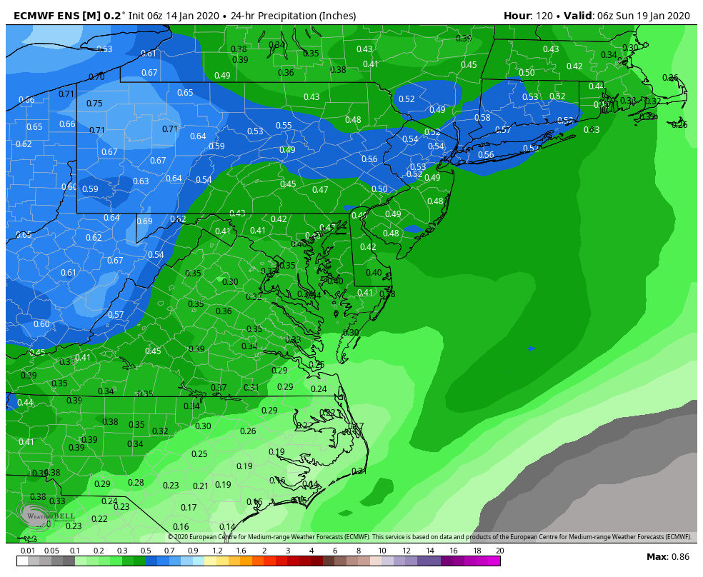
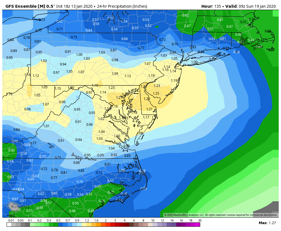
The temps are very similar on the gfs/gem/euro. But compared to the 1”+ qpf the others are spitting out during this same time period the euro is simply too weak with the WAA precip. keep in mind some of that (as with the others) is rain. So it’s really only showing about .25-.35 qpf over 12 hours when we have the colder profile...not very thumpy and not good enough to mix out the warm layer so it leans more sleet than snow. Still not nothing. Shows the potential for 1-2” of snow/sleet across the area but it’s a more typical minor event compared to the depiction it (and some other guidance still) was throwing out there earlier. Still time to change.

-
6z eps isn’t going to make many friends. Problem isn’t temps. The euro is shifting the WAA precip across PA to our north. It’s very dry here. Basically a period of light mixed precip yo dryslot then some showers with the front.
-
Gem actually trended quite a bit colder and south
-
When did it trend slower/Amped? Euro has tended to be over amped about day 4-6. Then sometimes over corrects and trends slightly more amped again in the short range. I’ve noticed that cycle several times the last couple years.
-
We’re still at a range where these shifts are noise. Only feels significant because we are on thin ice in west track scenarios needing everything to go right. But if we were in Binghamton NY the last few runs probably seem nearly identical. And it’s only the euro that trended north not all guidance. Lot of time
-
Is there a stage where your posts get better? Asking for a friend.
-
The gfs and euro are pretty similar wrt to the major h5 features but the euro is 5mb deeper in the Midwest with the surface low. The amplification slows the system and pulls it north. Wrt to everything else they are fairly similar for that range.
-
18z eps was not a good run.
-
It’s pretty obvious that storms like Feb 83, Jan 96, Feb 03, Dec 09, Feb 10, Jan 16 are roughly our max potential. (And a potential of 24-36” region wide is nothing to scoff at). There are lots of colder places that would be envious of our top end potential. The exact placement of the snow max will depend on meso banding but those storms were all examples of max potential around here. 2003 was the oddball in that it lacked blocking but it had a monster 50/50 to compensate. The rest had blocking.
-
18z op euro slightly less amped in the Midwest and colder in front at 90 when it ends. Won’t extrapolate but that isn’t a bad thing.
-
That wasn’t my point. I was just saying it’s still a looooooong way out there. NWS is conservative.
-
Everywhere in our region except the places like Snowshoe Canaan and Deep Creek temps are more correlated with snow than precip. That is even more true on the coastal plain than west of the fall line. Up here on Parr’s Ridge it’s a closer call but still temps. (On a weekly bases, not necessarily daily as obviously you need precip to be snowing).
-
EPS has been very consistent. GEPS was good too. One gefs run doesn’t phase me. And I’m probably being greedy here but wouldn’t it be nice to score a couple hits before Feb and roll into our snowiest month pretty much already having achieved our goal and be able to just relax and take anything that comes as icing on the cake? No more needing a homerun in the bottom of the 9th crap!
-
They’re not? Wait did you mean 5pm today, or tomorrow, or Wednesday, or Thursday, or Friday???
-
I will say this, if it’s really cold it lowers how much snow I need to be happy. 1977, for example, was only about 50% of normal snowfall here but it was so crazy cold all the little 2-4” snowfalls built up to a 10” snowpack and there was snowcover for over a month straight. Sign me up for that. On the other hand if it’s a warm pattern and it’s going to melt like it’s July it needs to be a bigger event so it’s at least not gone within 24 hours for me to feel as content.
-
Yea I should hit the “doesn’t bother me” harder. Just saying that one run was “extra” as my students would say.
-
18z Gefs goes suppression in the long range. Bone dry after the weekend storm through the end of the run. That is the most likely way we fail if we don’t snow. One run doesn’t worry me but we don’t want too much of a good thing. Day 8–6
-
Nice axis of precip Ninja’d

-
I’m taking the wife to a B&B in Gettysburg this weekend. A little snow could be a nice touch.
-
The euro isn’t superior by enough to just ride with it no matter what. Especially in specific situations when adjusting for its typical error bias is rational. It’s been over amplifying systems lately.
-
This is a lot more fun than day 15 pattern chasing
-
I agree. If you get some luck...this kind of pattern can actually be better from an "excitement" POV. Obviously 2010 was the exception but that was a once in a lifetime thing... most big blocking patterns don't go down that way. The double edged sword, and I know you know this... with a big arse NAO block is that we need the pattern to start to break down to hit a big storm...and then usually that means soon after we warm up and have to wait for a reshuffle. Often a big block will recycle and give another shot later but its often not right away. This pattern could throw opportunities at us rapid fire if we get the stj going and the trough axis aligns right. So while the chances of a hit with any one storm aren't as high...this could offer more sustained entertainment in here. See 2014/2015...
-
If in a month we are having a debate whether the pattern was more like the Bengals or the Browns...do you really think it matters?
-
@Bob Chill EPS REALLY likes the day 10-15 period....