psuhoffman
-
Posts
26,285 -
Joined
-
Last visited
Content Type
Profiles
Blogs
Forums
American Weather
Media Demo
Store
Gallery
Everything posted by psuhoffman
-
I can't keep track of who is saying "cold" and who is saying "warm". I swore a little while ago someone was posting BAMWX stuff saying it was going to get cold and snowy. And just 24 hours ago twitter was lit up with "here it comes, cold/snow" posts and suddenly its the opposite. Don't get me wrong todays 12z runs were less than inspiring, but they were just one run, and werent a dumpster fire...just a step in the wrong direction. If we hadn't had such good looks recently we would think todays runs were great. Don't get me wrong its important to change with new information. I have changed my mind a couple times this winter...but each time it took a week of trending across different sources of information, not a single run. That is crazy.
-
That is kind of an exaggeration. It flipped from extremely cold to kinda meh. Next week is still very cold...but bone dry. If the EPS is right there is no chance of any precip from Sunday to the following weekend. That is where the problems start...its shifting the ridging up top too far southeast...instead of an EPO ridge its centered across central and eastern Canada cutting off the cold air source and creating too much ridging in the northeast for storms to possibly cut. It's not an awful look and we have snowed with some luck in such a pattern...but its not the really good look for that period of a few runs ago. After that it starts to get back to the idea of an eastern trough...but even then its more muted and the ridging up top is weaker. It was a disappointing run IMO. I wont deny it. But its not a total disaster either.
-
Not a fan of todays EPS. Slightly degraded everything. It's frustratingly close to good but each discreet event took a wrong turn. The weekend has been handled in detail. It moved towards squashing any hope of a system next week. And now trended towards the op GFS idea of sliding too much ridging into the east and cutting the day 11/12 storm. Snow mean took a major cut reflecting these changes. The overall longwave pattern hasn't changed much...but you can't see the smaller details that will determine the fate of each specific threat from range and as they have come into closer range the warts start to show. As of right now, this this run, there were too many warts on each threat window. Still leaves us at a good look day 15. The good news is each threat is "close" enough that small adjustments (and adjustments will happen) could put us back into a good spot for each one.
-
EPS supports the op. Getting to the range where it likely will most runs.
-
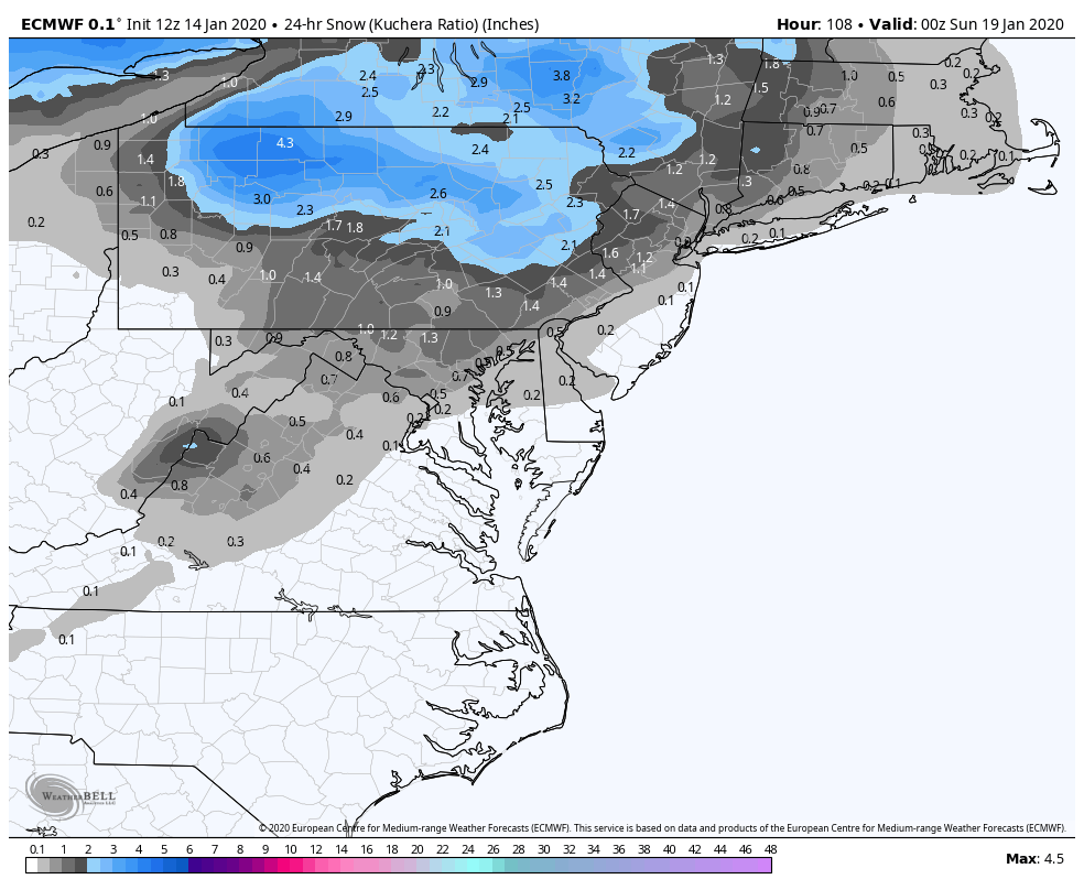
2-4 is a LOT from a storm cutting over Chicago in the middle of an uber ridge.
-
Euro is setting up a day 11/12 storm...no surprise that is when the GEPS/GEFS/EPS have said our next big chance at snow is. Before that we would need the ridge axis to back off some out west for the threat next week...otherwise its a southeast coast threat. I am realistic about snow...or at least I try to be. I got 7" last week and it stayed on the ground for 3 days. I got to enjoy it several times with my kids. If I can say 2 more similar events this winter... or one more good storm and a week of cold behind it to keep snow OTG...I will call this year a win no matter what the "number" says. Bottom line would be I got a couple opportunities to play in the snow with my children and a week+ with snow OTG to enjoy the scenery. Chasing a number we know statistically we are unlikely to reach 70% of the time is just a setup for...well being you.
-
I am always cautious when we see long range guidance spit out a lot of snow from a cutter. It does happen. And we remember those times it did. But in reality for every one of those there are way more that just end up being a mostly rain event. This one has a pretty good antecedent air-mass so it still might end up better then the majority...but the specter of big snows from these west track lows is a lot more of a longshot than we make it sometimes. Every few years one of them ejects a lead wave that directs a strong mid level wave into the CAD and we get a nice thump snow...and then we think there is a good chance of that every time a cutter comes along with cold air in front of it. What guidance is moving towards now is the more typical outcome. I am not saying there is no chance it doesn't trend back towards a nice lead wave...but odds always were and continue to be against it. We probably would be in a much better place mentally had the guidance not teased us for 24 hours with the rare snowy outcome from this type of thing.
-
relax...I know the rug pull over the weekend storm hurts a bit, but honestly had the models never teased us with some kind of crazy thump snow from a storm cutting to Chicago we would be in a much better mood. Nothing has actually failed yet except a setup that was never good from a longwave pattern POV to begin with. (assuming we don't make a miraculous comeback on the weekend WAA wave).
-
and without NWP there would have been absolutely NO FREAKING IDEA that there was even a remote chance at any frozen precip Saturday beyond simply taking a WAG. So yes at day 5/6 there is a HUGE spread...but that spread is between a little bit of non consequential snow/ice to rain and a decent thump snow to dryslot. As we get closer the guidance will narrow the possibilities until we get within 48 hours and they typically show a realistic range. But the bottom line is the NWP can outperform humans with no help from guidance at EVERY RANGE. Yea the range and accuracy isn't perfect at day 5 but before NWP humans didn't even attempt to forecast details that far out because it was impossible. You do not grade NWP on a realistic scale.
-
Also..looking at the last 48 hours of runs...good and bad, the actual strength and position of the shortwave is irrelevant to the results here. With the better runs were solely the beneficiary of a lead wave of WAA precip associated with strong mid level winds directed into the CAD in the mid Atlantic. But as the ridge continues to strengthen, sharpening the trough...there will be no wave and the WAA with the main system will be directed well to our NW.
-
Euro 36 hours ago Euro Now If this keeps up those with chase plans might want to look into Quebec City
-
More time to pump the ridge in front. Euro is close to a total non event now.
-
early on Euro still trending the wrong way
-
So if we can’t snow with these temps and this precip for week 2..... let the debate whether we are the Browns or Bengals begin...

-
Seemed good enough to me. Moved the right way with the day 11/12 threat. It's closer to a good result than previous runs. This run it dives a northern stream feature in and keys on that... there are 2 minor adjustments though that would make this setup work. Either get rid of that NS feature and focus on the STJ one. Or have it dig more. After that its setting up a good look at the end Confluence locked in to our north, that wave is going to get forced under us.
-
After a solid week of the MJO signal improving (moving towards a strong 7/8) today was the first day it took a step back, more towards a quick death in 7 then a recycle towards 6. That is something to keep an eye on. But even if it did recycle towards 6 so long as it progressed from there it might only be a brief relax in an overall cold period.
-
Couple things... I thought Snowy was calling for a cold/snowy second half of winter...did he change his mind on that? But more importantly, not sure I get what their point is wrt the IO base state. It is true that a wave near the dateline is "better" but a phase 2/3 in February is a cold look also. So not sure what that was about...
-
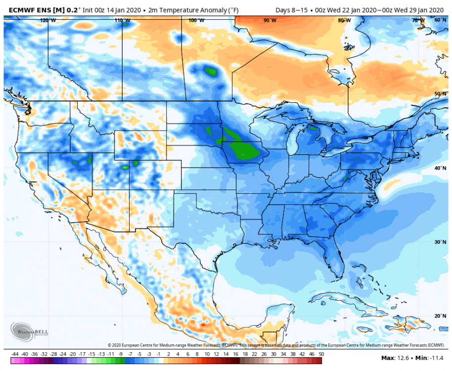
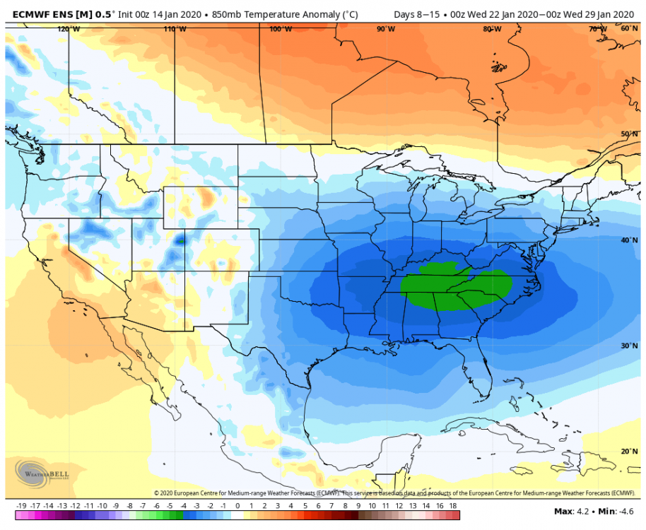
Can't ask for a better signal at long range day 8-15 EPS surface temps EPS 850 EPS mean Precip

-
The op gfs has a completely different pattern evolution next week than the GEFS/GEPS/EPS. Old runs, the 12z is "coming around" and if it werent for really bad timing with the lakes low probably would be a snowstorm... but the difference is how they have been handling the ridging across Canada. ALL guidance agrees that early next week we get a strong ridge near Hudson bay in conjunction with a western ridge slightly too far east...a ridge near Hudson would be perfect if we had a -PNA (but of course as soon as we need a western trough it abandons us LOL) but with a western ridge centered east of the perfect and a strong ridge near Hudson that is a very suppressive look and a great look for a possible SE snowstorm. I would love the look next week if I was on the outer banks. After that the op GFS was alone in sliding the whole of the ridge near Hudson Bay into New England. The rest of guidance breaks a piece off but the main ridge hangs back and remains anchored near Hudson Bay. The op GFS ends up redeveloping a new Ridge in western Canada but that creates a weakness between the ridge in the northeast and the one in the west for a trough to amplify to our west op GFS from 6z. I highlighted the features I mentioned. All other guidance agrees with the GEFS look for this same time Hence the EPS/GEFS/GEPS all agree on a risk of a snowstorm in the day 10-15 period while the op GFS had a warm solution.
-
GFS trended towards the euro wrt what I posted earlier...it was clear to see pretty early on in the midwest, sharper trough, more consolidated system, not good. Frankly the GFS has been trending that way for the last 24 hours also...it just overcame it with a stronger mid level flow out ahead but as the trough continues to sharpen that energy will end up directed northwest of us.
-
It beefed up precip slightly towards the end...AFTER we lose the column for snow. Might be more "icy" 6z v 0z but less snowy...I am NOT a fan of ice so for those that want ice 6z could possibly be a better run. Preference. But if you look at precip early on when we have the column it was a slight reduction hence the cut in snowfall totals across MD.
-
up until 12z runs...the GGEM/GFS are in agreement with a broader mid level flow and lead wave, the Euro/ICON agree on no lead wave. I haven't seen anyone post the UKMET so no idea what it's doing. I will be interested to see what the high resolution guidance does once it gets into range.
-
From the precip distribution pattern I would guess the ICON is in the euro camp wrt the mid level flow.
-
@H2O The effect is even more dramatic at 18z GFS Euro There are 2 ways to look at this... The Euro is actually the colder solution with a better SLP track and CAD. If it adjusts towards a broader mid level trough which allows a front runner wave with more mid level WAA directed into the mid atlantic...the euro might actually end up BETTER than the GFS/GGEM. Keep in mind it still manages 1-2" across our area Saturday evening even though it has NOTHING during the day Saturday when the GFS is thumping us. It is significantly colder. On the other hand if the euro is right and the system ends up with a very sharp mid level trough that directs all the WAA to our west there is a severe cap on how much frozen we can really get with this given the primary low is most definitely going to track well northwest of us.