psuhoffman
-
Posts
26,285 -
Joined
-
Last visited
Content Type
Profiles
Blogs
Forums
American Weather
Media Demo
Store
Gallery
Everything posted by psuhoffman
-
the TT snowfall maps count "ice" as snow. It's a known thing...so its kinda annoying when people post that map and say "haha look at how stupid this is showing 15" of snow when its going to be like 2". The model is NOT showing that. Those maps have a major flaw. That's why we call them "clown" maps.
-
Wernt the Models recently showing a big nao in the 6-10 day window? Briefly and it’s still there next week but it’s a wasted window (probably) because the trough axis is too Far East. Was about to post on that. Looks like a great chance for the southeast coast though.
-
What is frustrating is we keep cycling between the PAC and ATL taking turns crapping on us. The pac looks to get pretty good for the next 2 weeks but the scandanavian ridge suddenly flips to a trough which allows more ridging to shift across into a position that could muck things up. It's still not a bad look...but "one thing" keeps going wrong. The thing is..that is normal. Because to get snow we need so many more things to go right than wrong...that more often than not one thing will muck it up. Kinda like a golf swing.
-
Before I start a weenie stampede I should clarify that this setup does not have the upside those other storms I referenced did. I was purely using the airmass similarities. Without Atlantic blocking this storm would be more progressive. If it rides the coast it would likely blast up the coast not stall and dump on the mid Atlantic. But those can still be very good snowstorms. Just usually not 2 foot HECS ones. And it would have a higher chance of cutting. And if it did stale cold won’t work. I was simply saying if we get a 990 low up the coast with a perfect track I do not buy the rain scenario.
-
I will say this...if we do get a miller a storm with a perfect track (barring bad luck with a NS vort like the HH gfs run) I don’t buy the rain idea. I said the same thing when the Jan 2016 storm first showed up around day 12 and was warm on guidance. Euro was showing a perfect track gulf low rain storm when it first came into day 10 range. And I said BS. If it goes down like that in January stale cold will be good enough. Feb 5 2010 also was warm at really long range. Same reason. Same result. History/climo says stale cold stuck under a Canadian ridge is good enough with a good storm track in January and February. Climo for an advertised pattern beats nwp output range most times. We need the nwp to help with pattern recognition but I’ll take what history says should happen with the details.
-
Good luck analyzing a clipper at 150 hours. The day 10 stj thing is what I’m talking about. You’re right about discreet things not showing until inside 4/5 days...but the problem is it’s hard to spend a lot of time analyzing something that hasn’t shown itself yet. Could an unseen vort pop up in the cold window next week? Sure. It’s a pretty suppressive flow though. But maybe that relaxes some. Problem is that’s all pure speculation with no meat to analyze.
-
Go back on TT and cycle through the gfs and euro runs the last 72 hours and compare the “snowy vs not” runs. The strength and track of the primary have no correlation to our snow with this setup. The runs that had less ridging and this a more elongated trough to the east of the low to direct the winds ahead of the system more east into the mid Atlantic (hence WAA) were good. Regardless of the primary low location. The runs with more ridge and sharper trough were bad, regardless of the low. Now if you adjusted the low far enough south it would matter. But that would have to be a huge adjustment. Moving it 50 or 100 miles won’t matter when it’s cutting through Wisconsin. An adjustment from Green Bay to Milwaukee won’t help.
-
I thought that too (and there is some of that) but even some of the members with 990 lows off the coast that bomb us with precip are just rain. You see anything under 240 worth focusing on?
-
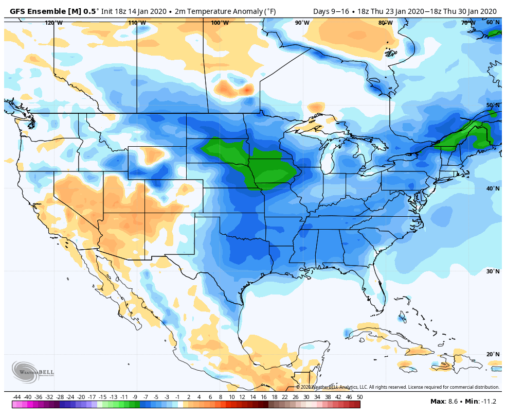
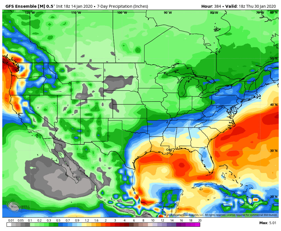
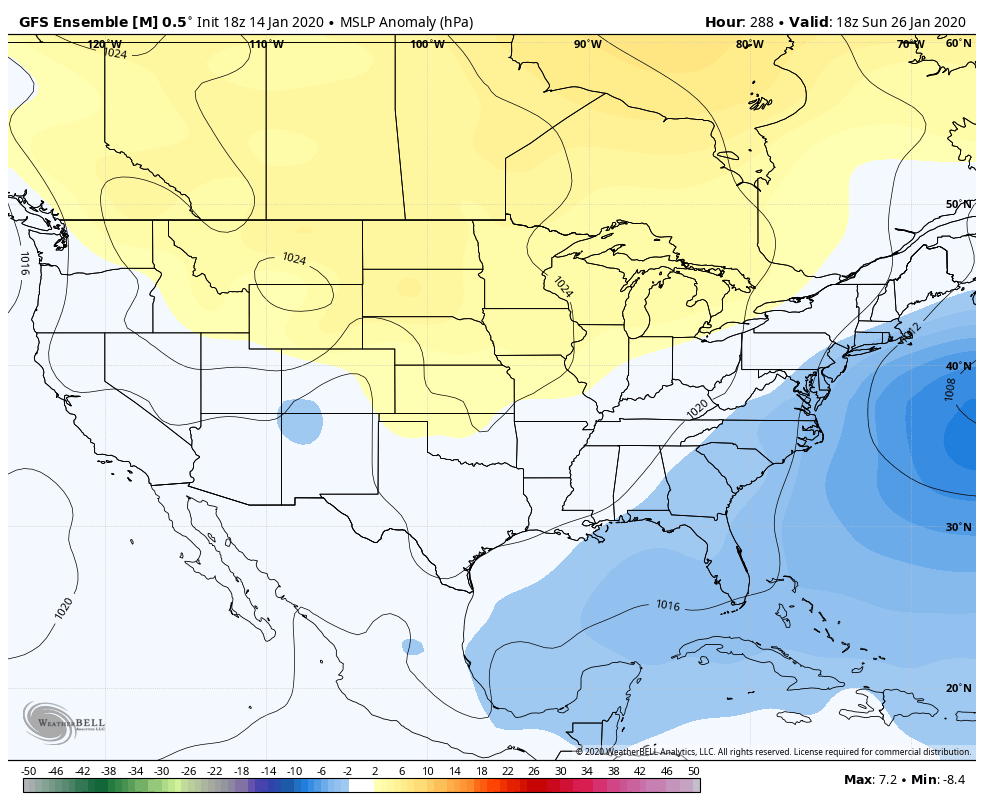
I am legitimately perplexed by the lack of hits day 10-15 on the eps and gefs given the h5 look. Even when you examine the mslp and precip...it’s a coastal track. Not cutters. And it’s not warm. Not really cold but below normal the whole period. It looks great. Then you look at the individual member output and it’s a bunch of 36 degree rainstorms from a perfect track miller A storm! Now I see the “wart”. The ridging in Canada gets centered too Far East which cuts off the cross polar flow so we end up with stale cold across the conus after the initial dump next week. But that setup (ridge bear or just west of Hudson Bay) has been a staple of mid winter snows here. In my study it was the second most frequent feature to an NAO block to signal snow. Like an NAO pattern it’s not an arctic cold look but it’s January. Prime climo. Stale cold air should be good enough. It was in Feb 2010. That was the same general airmass, leftover cold from the dump late January that was cut off under blocking across Canada. It was a garbage airmass by Feb 5. Would have been 45-50 degrees if it was sunny with no snowcover. But it worked with storms tracking under us. I know I’m ranting but my god that pattern should work. Maybe it will and guidance is off by a few degrees at range. I hate to bring you know what up with you know who around but seeing a pattern that has been bread and butter for us in the past look “just a couple degrees too warm” in prime climo (literally this is the coldest/snowiest part of the year) really is frustrating.
-
The longwave pattern still looks as advertised. Problems are with details that cannot be seen in long range.
-
@frd still no idea what he meant wrt the IO standing wave in 2/3. That’s a cold look in February.
-
The primary is south but that hadn’t mattered at all on past runs. It has no WAA surge to the east. Precip is nowhere near us at 12z. That run won’t end well imo.
-
@Bob Chill looking at h5, slp anomalies, precip, temps, I expected to see a lot of hits on 18z gefs...but no. A couple but when I saw the lackluster snow mean I checked out the members. A lot of coastal scrapers or OTS. A couple hits. But the majority that come up are perfect track rain storms according to the members. Odd. I guess a 36 degree rainstorm would still show up as a “below normal day” becauss we suck that much. Just not the profile of a rainstorm. Seriously this is a rain look now...I have a hard time buying that


-
Strengthen the western ridge or shift it east some...weaken or shift the eastern one west, and you end up with the upper low where we want it. Not a big change at day 12.
-
Screw 984 lows east of OC...we like our snow with a low cutting hundreds of miles NW of us!!!
-
Dude if you go out to the midwest in a hot air balloon at about 6,000 feet and blow facing east really hard you might be able to reel this one in.
-
I was having fun with that but one thing worth mentioning. It’s low odds. It’s not the most likely outcome. But there are enough absolute snow bombs with that threat day 11-12 on the GEFS/GEPS/EPS that while the odds do not favor snow right now, there is the chance that could be a big storm if it breaks right. Being cold enough seems the largest obstacle att.
-
It actually trended better. But still too much ridging in front and not enough behind so the mid level trough goes neutral too far west and floods us with mild air on the southerly flow ahead of it. Strengthen the ridge to the west and weaken the ridge to the east and it’s suddenly a big snow. Like I said yesterday it’s a cows fart in the right direction from a snowstorm. But gotta laugh at that. That would be painful.
-
We spend the entire run after Saturday with below 0 850s EXCEPT for the 12 hours it’s precipitating...and it’s not a cutter..it’s a 984 bomb off Ocean City. SMH
-
This isn’t fair
-
I still think ice is a real threat. Im just am not a fan of ice so I don’t talk about it much.
-
12z GEPS was a good run.
-
I remember us talking with Wes before the Feb Storm when it was 10 days away about how perfect it looked on that run and “Shame it has no chance to be right”. lol
-
Exactly...we should only listen to forecasters who are perfect and never get anything wrong!
-
At the end of the day we manage to fail on this specific run with a 10 day period of below normal temps and near normal precip... but its because hidding within that is a 7 day period of bone dry followed by a 24 hour warm up when all the precip comes...lol On the other hand...back off the ridging a little bit...and suddenly there are 2 legit threats with a relatively minor adjustment.