-
Posts
27,418 -
Joined
-
Last visited
Content Type
Profiles
Blogs
Forums
American Weather
Media Demo
Store
Gallery
Everything posted by psuhoffman
-
Not a fan of todays EPS. Slightly degraded everything. It's frustratingly close to good but each discreet event took a wrong turn. The weekend has been handled in detail. It moved towards squashing any hope of a system next week. And now trended towards the op GFS idea of sliding too much ridging into the east and cutting the day 11/12 storm. Snow mean took a major cut reflecting these changes. The overall longwave pattern hasn't changed much...but you can't see the smaller details that will determine the fate of each specific threat from range and as they have come into closer range the warts start to show. As of right now, this this run, there were too many warts on each threat window. Still leaves us at a good look day 15. The good news is each threat is "close" enough that small adjustments (and adjustments will happen) could put us back into a good spot for each one.
-
Euro is setting up a day 11/12 storm...no surprise that is when the GEPS/GEFS/EPS have said our next big chance at snow is. Before that we would need the ridge axis to back off some out west for the threat next week...otherwise its a southeast coast threat. I am realistic about snow...or at least I try to be. I got 7" last week and it stayed on the ground for 3 days. I got to enjoy it several times with my kids. If I can say 2 more similar events this winter... or one more good storm and a week of cold behind it to keep snow OTG...I will call this year a win no matter what the "number" says. Bottom line would be I got a couple opportunities to play in the snow with my children and a week+ with snow OTG to enjoy the scenery. Chasing a number we know statistically we are unlikely to reach 70% of the time is just a setup for...well being you.
-
relax...I know the rug pull over the weekend storm hurts a bit, but honestly had the models never teased us with some kind of crazy thump snow from a storm cutting to Chicago we would be in a much better mood. Nothing has actually failed yet except a setup that was never good from a longwave pattern POV to begin with. (assuming we don't make a miraculous comeback on the weekend WAA wave).
-
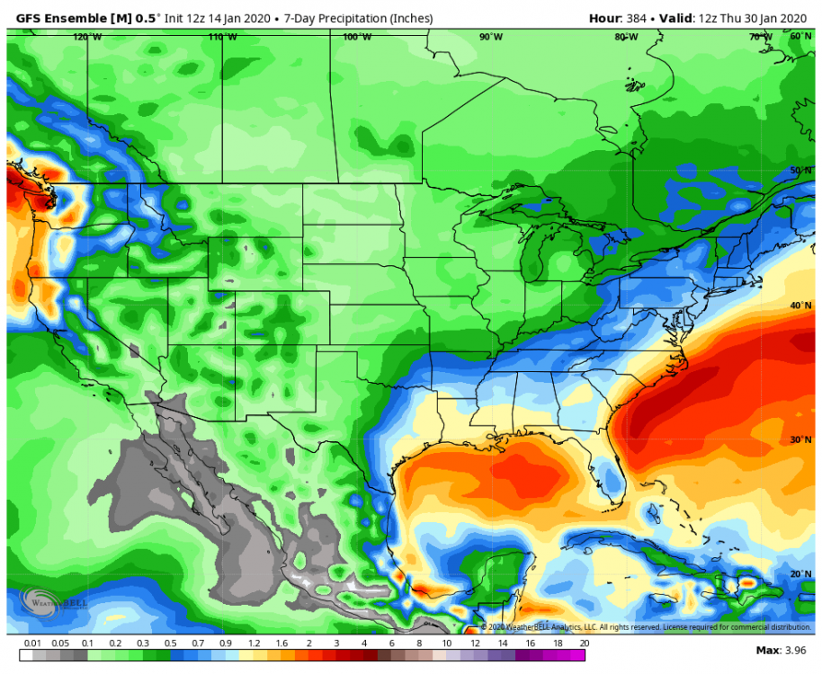
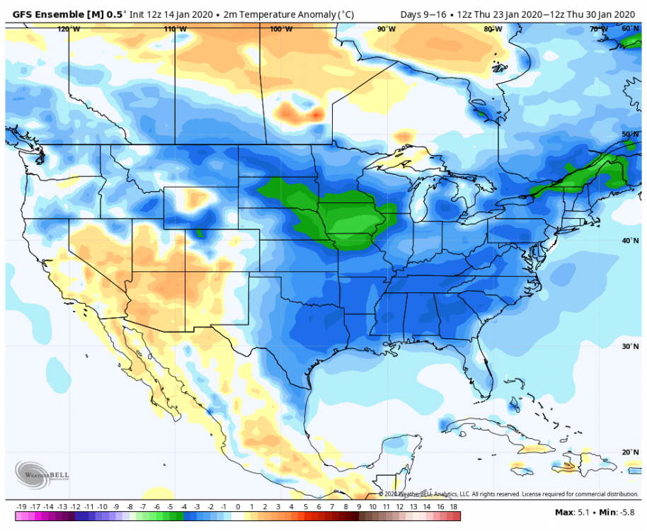
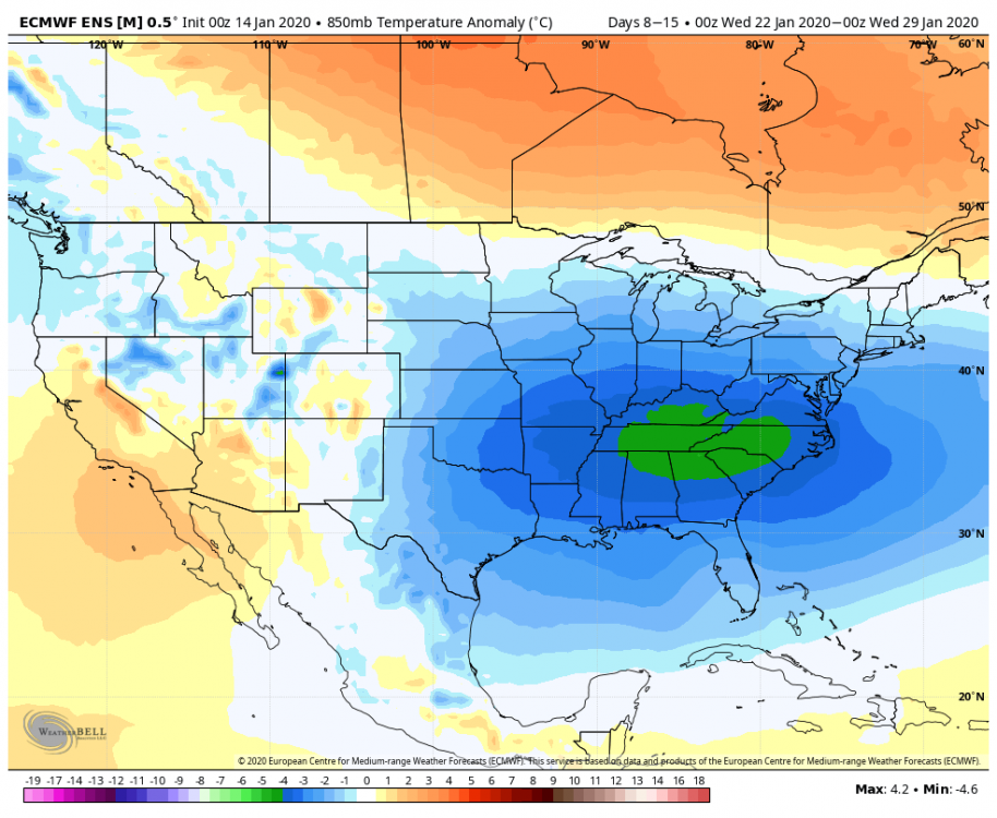
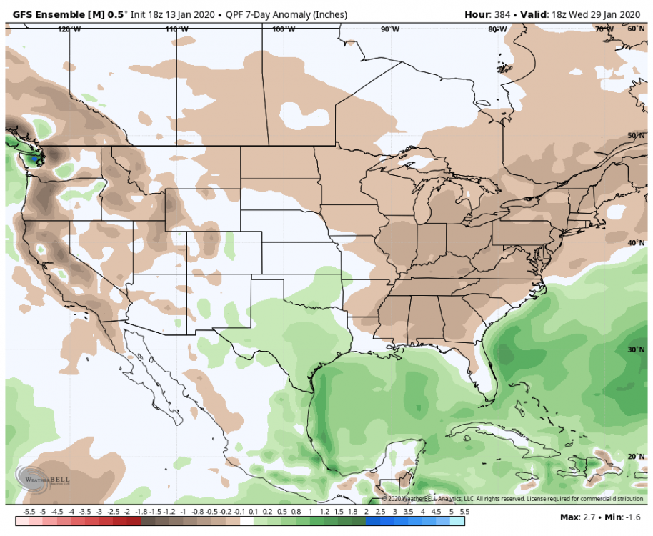
So if we can’t snow with these temps and this precip for week 2..... let the debate whether we are the Browns or Bengals begin...
-
Seemed good enough to me. Moved the right way with the day 11/12 threat. It's closer to a good result than previous runs. This run it dives a northern stream feature in and keys on that... there are 2 minor adjustments though that would make this setup work. Either get rid of that NS feature and focus on the STJ one. Or have it dig more. After that its setting up a good look at the end Confluence locked in to our north, that wave is going to get forced under us.
-
After a solid week of the MJO signal improving (moving towards a strong 7/8) today was the first day it took a step back, more towards a quick death in 7 then a recycle towards 6. That is something to keep an eye on. But even if it did recycle towards 6 so long as it progressed from there it might only be a brief relax in an overall cold period.
-
Couple things... I thought Snowy was calling for a cold/snowy second half of winter...did he change his mind on that? But more importantly, not sure I get what their point is wrt the IO base state. It is true that a wave near the dateline is "better" but a phase 2/3 in February is a cold look also. So not sure what that was about...
-
-
The op gfs has a completely different pattern evolution next week than the GEFS/GEPS/EPS. Old runs, the 12z is "coming around" and if it werent for really bad timing with the lakes low probably would be a snowstorm... but the difference is how they have been handling the ridging across Canada. ALL guidance agrees that early next week we get a strong ridge near Hudson bay in conjunction with a western ridge slightly too far east...a ridge near Hudson would be perfect if we had a -PNA (but of course as soon as we need a western trough it abandons us LOL) but with a western ridge centered east of the perfect and a strong ridge near Hudson that is a very suppressive look and a great look for a possible SE snowstorm. I would love the look next week if I was on the outer banks. After that the op GFS was alone in sliding the whole of the ridge near Hudson Bay into New England. The rest of guidance breaks a piece off but the main ridge hangs back and remains anchored near Hudson Bay. The op GFS ends up redeveloping a new Ridge in western Canada but that creates a weakness between the ridge in the northeast and the one in the west for a trough to amplify to our west op GFS from 6z. I highlighted the features I mentioned. All other guidance agrees with the GEFS look for this same time Hence the EPS/GEFS/GEPS all agree on a risk of a snowstorm in the day 10-15 period while the op GFS had a warm solution.
-
It’s pretty obvious that storms like Feb 83, Jan 96, Feb 03, Dec 09, Feb 10, Jan 16 are roughly our max potential. (And a potential of 24-36” region wide is nothing to scoff at). There are lots of colder places that would be envious of our top end potential. The exact placement of the snow max will depend on meso banding but those storms were all examples of max potential around here. 2003 was the oddball in that it lacked blocking but it had a monster 50/50 to compensate. The rest had blocking.
-
That wasn’t my point. I was just saying it’s still a looooooong way out there. NWS is conservative.
-
Everywhere in our region except the places like Snowshoe Canaan and Deep Creek temps are more correlated with snow than precip. That is even more true on the coastal plain than west of the fall line. Up here on Parr’s Ridge it’s a closer call but still temps. (On a weekly bases, not necessarily daily as obviously you need precip to be snowing).
-
EPS has been very consistent. GEPS was good too. One gefs run doesn’t phase me. And I’m probably being greedy here but wouldn’t it be nice to score a couple hits before Feb and roll into our snowiest month pretty much already having achieved our goal and be able to just relax and take anything that comes as icing on the cake? No more needing a homerun in the bottom of the 9th crap!
-
They’re not? Wait did you mean 5pm today, or tomorrow, or Wednesday, or Thursday, or Friday???
-
I will say this, if it’s really cold it lowers how much snow I need to be happy. 1977, for example, was only about 50% of normal snowfall here but it was so crazy cold all the little 2-4” snowfalls built up to a 10” snowpack and there was snowcover for over a month straight. Sign me up for that. On the other hand if it’s a warm pattern and it’s going to melt like it’s July it needs to be a bigger event so it’s at least not gone within 24 hours for me to feel as content.
-
Yea I should hit the “doesn’t bother me” harder. Just saying that one run was “extra” as my students would say.
-
18z Gefs goes suppression in the long range. Bone dry after the weekend storm through the end of the run. That is the most likely way we fail if we don’t snow. One run doesn’t worry me but we don’t want too much of a good thing. Day 8–6
-
I agree. If you get some luck...this kind of pattern can actually be better from an "excitement" POV. Obviously 2010 was the exception but that was a once in a lifetime thing... most big blocking patterns don't go down that way. The double edged sword, and I know you know this... with a big arse NAO block is that we need the pattern to start to break down to hit a big storm...and then usually that means soon after we warm up and have to wait for a reshuffle. Often a big block will recycle and give another shot later but its often not right away. This pattern could throw opportunities at us rapid fire if we get the stj going and the trough axis aligns right. So while the chances of a hit with any one storm aren't as high...this could offer more sustained entertainment in here. See 2014/2015...
-
@Bob Chill EPS REALLY likes the day 10-15 period....
-
I’m a little more optimistic maybe but not over any one threat. I agree this isn’t the look where we have one storm with a high probability. But we seem to be facing the potential for a prolonged pattern that includes a favorable east based epo ridge/block, an arctic dump into the EASTERN US, and an active southern stream. If that has any legs at all we will have multiple opportunities and the odds of abject failure would take Cleveland Browns level ineptitude.
-
You want to feel warm and fuzzy...look at the slug of moisture coming out of the gulf at the end of the 12z gefs run right into entrenched cold air. Before that there were discreet threats around next Tuesday and Friday/Saturday
-
@Bob Chill we can see both options for the potential stj system next week on the gefs. The GFS op dives the majority of the canadien ridge into the northeast. The ridge rebuilding west of Hudson Bay isn’t strong enough yet so the trough amplifies in the weakness to our west. But on the GEFS both options show. There is clearly two ridges there. If the one west of Hudson is stronger than whatever dives across to our north we likely get the coastal solution. If the ridge in the northeast is more dominant the system likely amplifies to our west. Gefs leans coastal. Eps was split. Too soon. Won’t be out last shot in this pattern it looks like.
-
It's there on all guidance yes. They all agree that a piece of the block in Canada will split and dive southeast and create some ridging a bit too far south than we would want for a short time. But how that plays out isnt' all hostile like the GFS op. The GFS really went crazy with that ridge and allowed the next wave to dig in and cut off to our west. That said...even with everything going wrong it still ended up only 100 miles from a big coastal storm. An inland runner at day 11 is not that big a deal. There are lots of options how that plays out...the EPS has quite a few where that ridge actually acts to suppress a system to our south...and a few big hits in that range. It's undecided how that ridge interacts with the other players. It depends on how strong a piece dives into the northeast vs remains up in Canada. More ridging "behind" that wave instead of in front and suddenly we have a 980 low off Ocean City instead of over Annapolis.
-
Last 3 GGEM runs
-
GEM significantly south of 0z.


