

psuhoffman
-
Posts
26,285 -
Joined
-
Last visited
Content Type
Profiles
Blogs
Forums
American Weather
Media Demo
Store
Gallery
Everything posted by psuhoffman
-
@Mersky what happened to all your CFS mjo phase 8/1 posts??? I was excited to return to an mjo cold phase bliss pattern! oh snap... ^that happened....nevermind. Carry on. Oh btw, have fun attacking isotherm in the NYC sub. I’m sureeee that will end well for you.
-
@mappyCongrats!!! Well deserved
-

Mid January/Mid February Medium/Long Range Discussion
psuhoffman replied to WinterWxLuvr's topic in Mid Atlantic
Like @Bob Chill said this is a long shot. Not totally impossible but not a high probability setup. Don’t get your hopes up. If we get lucky with an absolutely perfect h5 track and the storm bombs just right (that’s really our only chance) just thank our lucky stars. -
Mid January/Mid February Medium/Long Range Discussion
psuhoffman replied to WinterWxLuvr's topic in Mid Atlantic
2000 was a better example of a winter where the pattern was awful 90% of the time but we scored the one week it got right As for an HECS...I think what you are really asking is were there ever any HECS level storms in a similar setup to this week...because the surface matters too...there were a couple pretty big snows (not HECS but MECS level) with a Hudson Ridge but they all featured a significantly colder airmass to work with and a monster 50/50. Were there any 10"+ storms in the cities with this look and this type of airmass...no. There were some decent events though, not a lot...but enough to say its not completely impossible...but there were no 12"+ storms in DC/Baltimore with this look. That is asking a bit much given the situation. If somehow we managed to get 3-6" of wet snow into the cities that should be considered a massive win in this situation. -
Mid January/Mid February Medium/Long Range Discussion
psuhoffman replied to WinterWxLuvr's topic in Mid Atlantic
I assume you mean Feb 1987 because nothing happened in 1988 but 87 there was a foot of snow at IAD from a storm where it was 48 the day before and 46 the day after...the snow hit overnight mostly. That storm featured great blocking with a 50/50 heading into the event...but a stale rotting airmass and it was late February...so boundary temps with sunshine were torching...but mid and upper level temps were in much better shape than this coming situation. That was kind of the late February version of Feb 2010. There are some examples of "similar" patterns to this working, and most were mid winter. This is the composites of 16 warning level events at BWI with a hudson bay ridge. On the mean notice a 50/50 signature...that is the main thing we are lacking here. But there were a few within that set that also lacked a 50/50 but when I looked at most of those examples the antecedent airmass wasn't as awful as the one we are working with now. THe main problem is the ridging this week ends up centered a bit further southeast than where we need it. But there are some examples of similar "setups" that managed to work to some degree and get some wet snow into the cities and a decent thump NW. BUt for every one that works there were a lot more that didnt with this type of airmass. As you say its the most "interesting" look we have had so far...but that is a pretty low bar. It's far from a great look...but its not impossible. THe threat after has a better chance assuming guidance isn't completely wrong about how the pattern evolves. The key is getting this system to knock down the heights to our northeast and create a slightly better situation wrt the antecedent airmass for the NEXT one. A best case scenario would be to get a perfect H5 track and luck our way to a wet snow thump event from the first system...then have it pull in enough "somewhat colder" air to set up the next one.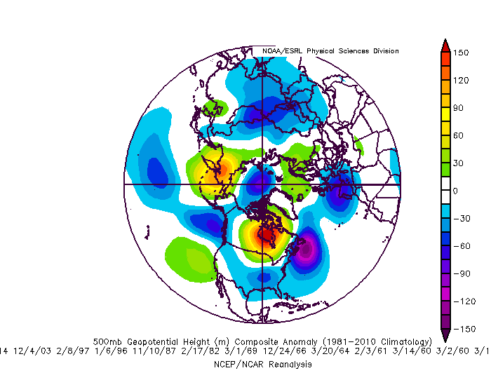
-
Had a great time in Gettysburg. Ate at Dobbin House, excellent food! Wife got to show of her new coat. I got a little excited for the drinks... Found some live music at Ploughmans tap house. Nice to get away and relax for a couple days. walking around wasn’t easy though with the ice. But we had a fun time. Apparently CashtownCoop saw us on the street but didn’t give a shout out. Would have been cool if he had. Anyways I’m recharged and ready to track the rest of our epic fails.
-
@Maestrobjwa you made a post the other day saying maybe we will get one huge fluke snowstorm like 2016, and I know you have mentioned 2006 the same way...only neither of those was a "fluke". 2016 had an excellent h5 pattern for 6 weeks in the core of that winter... and IMO it was bad luck that we didn't score more than one significant snowfall. I am NOT saying we should have had 2 storms like that HECS but if you showed me this look and said that would be the pattern for the 6 snowiest weeks of winter I probably would have guessed we would have got more than 1 significant snowfall. But we got very unlucky...we wasted a perfect track coastal storm before the HECS because temps were slightly too warm. Then another threat got suppressed and squashed...then one WAA wave went just south of DC and another storm went just north and there was a perfect upper low early Feb where the boundary layer was just too warm, my area got 8" and DC was cold rain. But if anything the fluke was that DC only got one snowstorm...NOT that they did get one snowstorm. 2006 was similar...the period from Mid December to Mid January was awful...but one of the best winter blocking periods of the last 20 years set in around Jan 25 and continued the rest of winter. THe nina pattern in the pac is evident with that ridge and the lack of an STJ...those features limited the potential here and is part of the reason why we only got one big snowstorm...but the fact that from Jan 25 to the rest of winter looked like that, with that blocking...and we only managed one snowfall of any significance is incredibly bad luck. Given the lack of STJ I don't think expecting multiple MECS level snows was likely but we probably should have had another minor to medium level event or two given that look for so long. My point is not that we wont get a big snowstorm...just that we don't usually "luck" our way to a 12" plus snowstorm in a crap pattern. Those level storms in the cities almost always go along with a favorable pattern (almost always blocking). We can "luck" our way to a 3-6" event in a crap pattern SOMETIMES... but once you get to 8" plus events in DC its almost always with a pretty favorable pattern. Sometimes there is a year where we only got one big storm...but usually that is because either bad luck and it should have been more...or a year like 2000 where we spent most of the year in a crap look but we got a short but excellent pattern for a week or two. I guess my point is don't expect us to somehow fluke our way to a 12" snowstorm in some god awful looking pattern. That almost never happens. For the record a Hudson Bay ridge (current pattern) is not the worst look for snow...its not the best either and temps will always be a struggle in this look...but we have managed some wet snow paste jobs in such a pattern, but they aren't typically HECS level storms...most were moderate snowstorms in the city...some were big in the NW elevated parts of our forum though.
-
maybe a touch better...but not quite as good as some of the snowy outcome "Hudson Bay Ridge" analogs either...those are also generally warm pattern storms also...but looking through most of those examples that worked the airmass ahead wasn't quite as torched as this one...of course the guidance is trending cooler so if that continues by the time the storm comes maybe it will look more like the better examples. A compromise might work for our area...we had a little bit of snow with some of those 1998 storms but we didn't quite have the elevation to get really thumped.
-
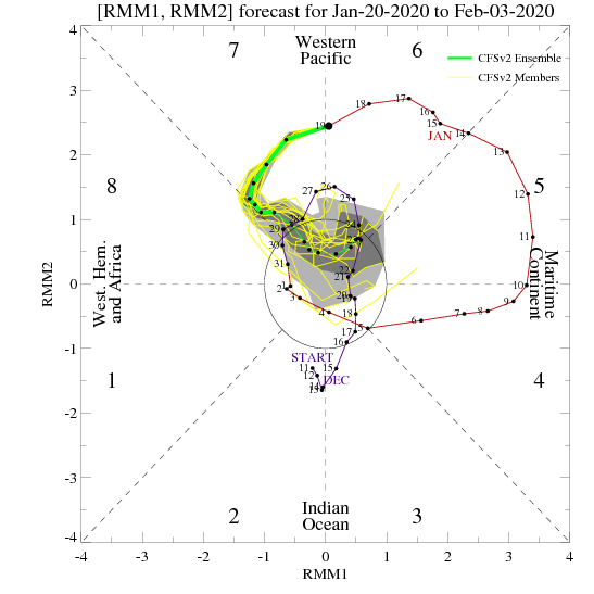
You don’t see this often at this range
-
It’s provably going to at least be close. The look is close enough to a lot of our wet snow in a warm pattern “look” but the antecedent airmass might be just a bit too atrocious for low elevations. This might end up like some of those 1998 storms that clobbered higher elevations.
-
I used 2001 for personal reasons. I remember a couple days before that disaster I purchased my first brand new car, a little black Honda Civic from Tyson’s Corner. I was buzzing that night. New car. Blizzard on the way. I was cruising around breaking the car in listening to WTOP to hear the weather every 10 minutes even though I knew what it would say. Then the next morning the rug pulled out as everything shifted north. But for one night...
-
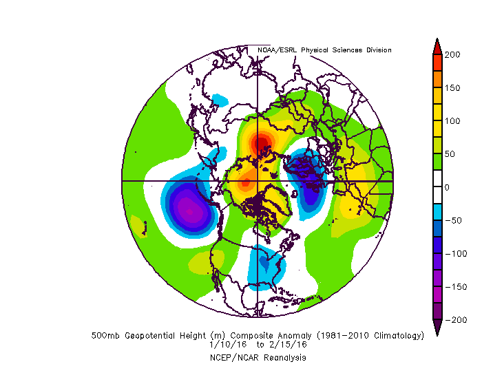
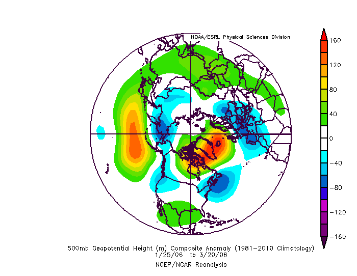
A Feb 2010 B Jan 1996 C Dec 2009 D Mar 2001 E Mar 1958
-
Yes there is a lot more to do in N Conway. The Conway area gets blasted in those New England coastals being so close to the coast on the east face of the White Mountains. The town does get some shadow effect in the valley but still has frequent 12”+ storms and some 20+ which is kinda rare for valley locations in northern New England. Some of the more remote places in the mountains around Conway get obliterated in coastals.
-
I know you’re busy...and I’ll be having some quality time with the wife...so maybe we should let Mersky take the wheel for the weekend. I fully expect to return to phase 8 bliss... blizzard warnings and talk of new biblical classifications.
-
The guidance mishandling of the play between the tpv and North Atlantic vortex really mucked things up. That phasing and consolidating into Baffin vs splitting and sliding out forces the canadien ridge too far south and flipped the pattern on a dime. It was one thing...but a BIG thing. Maybe one big thing will break in our favor one of these times.
-
Southside steakhouse at trolley square in Rutland is an excellent eat btw. Good luck. Have fun.
-
Been to Rangely when skiing the loaf. They always have a ton of snow. They don’t quite get the huge totals from coastals though as on the southeast faces of the mountain range. But they hold snowcover due to the cold being protected from coastal warm ups. Having been to rangely and n Conway on the same trips often (combining wildcat and loaf) Rangely will always have more snow otg but in a big storm Conway gets the bigger dump. Trade offs. Conway still has snowcover much of winter so I think I would sacrifice the crazy pack Rangely has from November to May...literally they usually still have a 2 foot pack in late April even...to get those crazy coastals. I still want to be able to root for those and watch the crazy death bands on radar.
-
E was March 58 other than the bust that one was maybe cheating since it wasn’t HUGE at DCA but it was most of the area and it’s a personal fave.
-
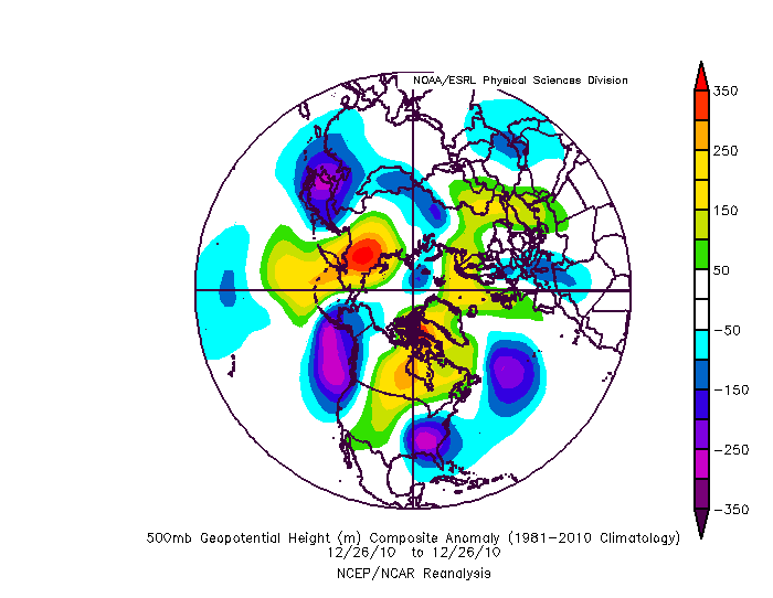
This is Boxing Day... it fits the cohort. But I only included one mega bust in the set and I think Boxing Day actually gave him some snow in Delaware...like 3-6” so I didn’t use that one. I could fill the set with busts and hits and you wouldn’t be able to tell the difference and that was my point. Pattern is only half the battle. Luck with micro scale features has to go our way too.
-
Good guess but no. B was a HECS. Jan 96. I’ll disclose soon if no one else wants to take a stab at it.
-
You have the most reason of anyone in here to be a cranky miserable arse wrt snow yet you are one of the most level headed posters. It’s easy for me too have a positive attitude given my climo/results but I admire your rationality. I do hope your location breaks the drought soon and or you find a snowier spot. Even up here I dream of moving somewhere like North Conway NH where 100” is a common occurrence.
-
It shifted quite a bit colder. But it seems to do that partially in response to bombing the day 10 storm then squashing everything behind it. Cold/dry day 11-16. But still a better look rolling forward than 12z was imo.
-
Good luck to her! I’m going to Gettysburg with my wife tomorrow for the day/night. I won’t be on here for a while. Mersky can handle things while I’m gone.
-
23/7
-
In fairness the gefs was better day 10-15 but dry. But closer to workable. It was a better trend fwiw.


