

psuhoffman
-
Posts
26,285 -
Joined
-
Last visited
Content Type
Profiles
Blogs
Forums
American Weather
Media Demo
Store
Gallery
Everything posted by psuhoffman
-
Maybe...but what you are seeing on the 300 hour guidance is not really a true -NAO or NAM state flip. It's the ridge under the TPV getting caught in a sqeeze play between the shifting AK vortex and the TPV over and north of Greenland. I do not see the wave breaking necessary to really force a permanent NAM state change from that...as of yet. The feature you are seeing isnt bad...and if the AK vortex does drop into central North America that is good... but I am not as hopeful that what your seeing day 15 is the permanent NAM state flip we need. I do think there is a chance that does happen, but its likely later in Feb or March if at all. We kind of have a mix of signals...we talked about in the fall how there are so many conflicting signals...but the combinations isnt going our way. We wondered how it would play out...and we did get a mix of some nino and nina like pattern features. Problem is the ones that ended up dominant were the worse of both worlds. We got the ridge near Hawaii and +NAM associated with a nina, and we got some central Canada ridging associated with a nino, but that combination isnt really going to cut it. Often in a nina base state winter we do see a more favorable NAM state phase change towards the end. My feeling is that the shortening wavelengths aid in heat transport and wave breaks attacking and disrupting the stable PV and make it more possible to get some blocking later. Shorter wavelengths can also make it more possible to get a fluke storm without help up top. So there is some support to the idea that the current mess we are in could change but that typically doesn't happen until later in Feb or even more common in March.
-
Don't disagree with your points... and I would also recommend anyone who gets emotionally invested (a lot of people) in day 10 forecasts should take a break... but for me personally I can look at long range...knowing full well how low probability things are, analyze the permutations of where the pattern could be going based on the limited NWP clues and seasonal tendencies, without it driving me crazy when particular results I want do not happen. But for most who cannot do that...avoiding long range is probably a good idea.
-

Mid January/Mid February Medium/Long Range Discussion
psuhoffman replied to WinterWxLuvr's topic in Mid Atlantic
We cannot overcome an AK vortex if the NAO is raging positive. We can and have snowed with an AK vortext...especially as we get later in winter...if the NAO is negative to block the pacific onslaught. But with both features the pac obliterates any mid level cold across north america. Likewise we can overcome a +NAO with an epo ridge. But if we continue to see an AK vortex AND a +NAO we are screwed. Yes I said SCREWED so here comes a post from you know who complaining about "how dare I declare winter over". Joking aside, maybe one or both of those features change from here on out, I would have more hope in the AK vortext than the NAO, but we are losing valuable prime climo everyday and odds of ending up with anything other than a bad winter are decreasing, not that I am surprised by that fact. But there is always "hope", there have been very rare cases where the pattern went through a complete reversal late...had the flip in 2018 happened maybe 2 weeks earlier we probably would remember that as one of the great turnaround years also. But when its so hard to get snow here to begin with...spending a huge chunk of our prime snow window in a shutout total crap pattern really makes it difficult. ETA: the only reason any of these threats the next 10 days are "close" is that Hudson Ridge. Those can sometimes overcome the larger crappy base state. It was actually the feature most at cause for our "bad pattern snowstorms". But even with that...we would need to get lucky with an absolutely perfect track amplified h5 system...and even then I am not so sure if it would work in the cities. -
If you go back over the last 5 days or so...and look at all the different analogs spit out by NCEP and CMC for the day 8 and day 11 looks... there actually were a handful of analogs that "worked" for some snow around here...but they were almost all from years in the 1950s-1980s. The h5 analogs that were more recent from the 90s on were all from big rainstorms. Just an observation... On top of that, as bluewave has pointed out...its becoming increasingly harder to get a legitimate "cold base state" to winter in the mid atlantic. Basically if we have an uber -EPO or -NAO the majority of winter we can get a cold winter...the rest of the time we are above normal. It's very hard to get a prolonged simply "normal" temperature regime unless its a temporary period of transition. Pretty much we need a very anomalous ridge in either the EPO or NAO domain to dominate...or else we are well above normal for winter.
-
DC could get 2" of snow the whole rest of winter and that would make your prediction true.
-
This is what I am chasing at this point...
-
Depends what our expectations are... if we are looking for some epic save where we manage to end up above climo for the entire winter just from snow Feb 15 onward...then yea that is incredibly unlikely. Only happened a few times in 100 years and only twice in the last 30. 1993 and 2015. But if we are simply looking for SOME snow and to creep out of the "total dreg dumpster fire" category winter like 2002/2008/2012 and into the just "typical" not good year like most years other than the rare 96,03,10,14 type years... that is more realistic. Still not "likely" but not as super lottery type odds. Getting a late "save" that brings us out of total "dumpster fire" into "just regular bad" year is more common. Something like 2018, 2009, 2007, 1999, 1976, 1972. Those are all years where BWI went into February with very little or no snow and then ended up at least closer to "median" by the end from either one lucky storm or a period of some snowfalls. That is a lot more common and a more realistic.
-
Mid January/Mid February Medium/Long Range Discussion
psuhoffman replied to WinterWxLuvr's topic in Mid Atlantic
They did...I didn’t include every example. I would say 2015 and 2016 were the rare cases where DC beat avg without an otherwise epic winter. Although the pattern in 2016 was pretty awesome just didn’t live up to potential imo. 2015 was a true lucky result. -
Mid January/Mid February Medium/Long Range Discussion
psuhoffman replied to WinterWxLuvr's topic in Mid Atlantic
DCA chances of above mean snowfall is only about 30% any year. So it’s not shocking that tossing 2/3 of winter doesn’t help the odds. It’s very rare for DC to beat avg without it being one of the rare anomaly winters like 1996/2003/2010/2014. Typically DCA either finishes way above avg or below. What DC should be hunting for is to get to hear a median winter which is about 10” and happens much more often with a bad start in non great wintes. That’s a more realistic goal imo. -
Mid January/Mid February Medium/Long Range Discussion
psuhoffman replied to WinterWxLuvr's topic in Mid Atlantic
Also wrt the mjo...it wouldn’t matter much if it managed to sneak into 8 at low amp as the wave dies for 1-2 days. The fact that it went to 3 stdv in phase 4/5 then dies as it reaches cold phases is the important thing. A strong wave in the MC will have done the dirty work ushering in an awful pattern. It will take an equally strong influence to counteract that. If the mjo continues to go strong through warm and weak through cold phases that’s a loss. Plus there is some feedback circular nature to it. When the mjo is working in symmetry with the other influences that cause the typical phase 8 central pac wave (central/west based nino) we see the canonical pattern. But when the mjo is out of sync with the background state the response is often muted some even when it’s in cold phases. We see the same in reverse in good years. A weak wave into warm phases isn’t usually a death sentence to winter after a strong cold phase wave. If we are in a cold base state a weak mjo wave won’t always derail that. The good news is with the mjo looking to be a weak influence ahead if we do get a change in other factors it won’t be counteracting that. But the mjo alone isn’t going to save us. We need either the central pac pattern or the high latitude one to flip and it’s apparent those are being driven by more than just the MJO. -
Mid January/Mid February Medium/Long Range Discussion
psuhoffman replied to WinterWxLuvr's topic in Mid Atlantic
His video was good but I think he made more of the VM than it is. We’ve had very cold -EPO winters in a VM pattern. 2014 was one. I even think the example map he used to compare a VM to a PDO that was 2014 on the left. Lol The mjo spiking so high into warm phases in the core of winter was a bigger deal. But again that’s an effect not a pure cause. But we can see the same effect we get in most warm winters where the mjo goes ape into warm phases and can barely sniff cold ones. That warm pool in the north pac has little to do with that. The energy released from the tropics is several magnitudes greater than water in the north pac. The configuration of the mid latitudes was all wrong to transport heat into the high latitudes and disrupt the PV this year. -
Mid January/Mid February Medium/Long Range Discussion
psuhoffman replied to WinterWxLuvr's topic in Mid Atlantic
The eps weeklies eject the vortex out of AK into central N America. Also weakens the NAM back closer to a workable look. Sets up a gradient pattern but with us on the right side for early to mid February. Best look is probably this week If that’s right that would imply we’re in line for waves and on the right side of the boundary. I know it’s worthless but I suppose it’s slightly better it looks good simply because when it’s an epic disaster that’s when it’s always right. -
Mid January/Mid February Medium/Long Range Discussion
psuhoffman replied to WinterWxLuvr's topic in Mid Atlantic
Lol...they’re actually good I’m just not sure anyone gives a crap. -
Mid January/Mid February Medium/Long Range Discussion
psuhoffman replied to WinterWxLuvr's topic in Mid Atlantic
Btw wrt the mjo...I don’t think it’s going to save us but I also don’t think it’s going to kill us in Feb. After a brief nudge into 6 (and even that signal is conflicted if you look at the actual convection, it likely goes null. Other factors are likely to drive the bus in Feb imo. Doesn’t mean they will be any better but I suppose they can’t be any worse so there’s that. -
Mid January/Mid February Medium/Long Range Discussion
psuhoffman replied to WinterWxLuvr's topic in Mid Atlantic
Should I bother to give a summary of the weeklies? -
First drinks on me!
-
I apologize, I assumed you were at a certain level. Since it’s quite clear you are not I’ll take it down a notch and try again. No you did not physically assault him. But within the online community attack can have non physical meanings. You took a post of his, twisted it’s meaning, then made an obnoxious comment. And yes I do worse sometimes but I own it. When someone is being as asshat I will occasionally “attack” them. But what I never do is then try to play this “who me” game or worse, some passive aggressive victim nonsense. You’ve done it with multiple people multiple times and it’s pathetic.
-
The 1960s were pretty snowy even there. She probably remembers that and thought that was “normal”.
-
When it snowed hard we’re you on 7 south between Rutland and Bennington? There are some high spots in there that get pasted good. If you chase on a non holiday weekend you can typically find lodging up in the mountains that do better.
-
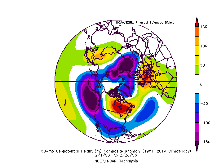
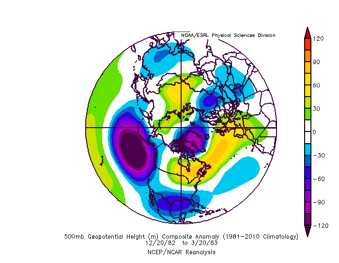
Context matters Tom wasn’t comparing the nino in 1998 to enso now. He was comparing the pattern. And you twisted his words as you often do. Feb 1998 EPS Next week The nino strength isn’t relevant, if the pattern is similar the results will likely be similar. When he brought up 1983, again, he was referencing the pattern much of that winter. And yes we had one anomalous snowstorm that winter but it was during this... so if an Uber NAO block like that shows up then you have a case, but Tom was pretty clear he finds the prospect of strong NAO blocking very unlikely and if we get any it won’t be until very late in the season. Absent that block we get what we got the rest of that winter in such a pattern. All he proved was that the “look” coming up has tended to be too warm for snow historically.
-
Mid January/Mid February Medium/Long Range Discussion
psuhoffman replied to WinterWxLuvr's topic in Mid Atlantic
Rain -
Mid January/Mid February Medium/Long Range Discussion
psuhoffman replied to WinterWxLuvr's topic in Mid Atlantic
When the background base state is unfavorable the mjo (even if it makes it into cold phases) tends to be ineffective. It’s more effective when it’s in coordination with the background state. If we get a flip it’s unlikely to be solely mjo driven. -
Mid January/Mid February Medium/Long Range Discussion
psuhoffman replied to WinterWxLuvr's topic in Mid Atlantic
Im not saying we can’t have a pattern flip. But imo if we do it won’t be mjo initiates (just like 2015 wasn’t). -
@RevWarReenactor how was Vermont???
-
I’m away 2 days and forget how everything works. Thankfully I cought it before I left it in the wrong thread.


