psuhoffman
-
Posts
26,285 -
Joined
-
Last visited
Content Type
Profiles
Blogs
Forums
American Weather
Media Demo
Store
Gallery
Everything posted by psuhoffman
-

Mid January/Mid February Medium/Long Range Discussion
psuhoffman replied to WinterWxLuvr's topic in Mid Atlantic
Not worth it. Either he is in here regularly and he knows that...in which case he is trolling, or he never reads this thread and he just dropped in to post that, in which case he is trolling. -
Mid January/Mid February Medium/Long Range Discussion
psuhoffman replied to WinterWxLuvr's topic in Mid Atlantic
It’s 7 days away. We wouldn’t even know there was a storm threat there if not for NWP. You can’t extrapolate the atmosphere to 150 hours with barometric pressure rules and wind plots. -
Mid January/Mid February Medium/Long Range Discussion
psuhoffman replied to WinterWxLuvr's topic in Mid Atlantic
Right now it’s in last place among major globals...and that was even before the major cmc upgrade last week. If that continues I wonder will there come a time the gfs becomes just a teaser like the icon as we wait for the big boys (cmc/UK/EC) to come in? -
Mid January/Mid February Medium/Long Range Discussion
psuhoffman replied to WinterWxLuvr's topic in Mid Atlantic
Oh well I thought the quicker would be better...didn't expect cutter again lol Upper levels amplified way too far west given the lack of blocking or cold in front. It was another solution where if we had a truly cold airmass or some blocking that progression would be a 3-6” snow to mix solution but with what we are working with just rain. -
Mid January/Mid February Medium/Long Range Discussion
psuhoffman replied to WinterWxLuvr's topic in Mid Atlantic
Yea but the mid and upper level trough is going neutral and amplifying west of where I want given our thermally challenged situation. -
Mid January/Mid February Medium/Long Range Discussion
psuhoffman replied to WinterWxLuvr's topic in Mid Atlantic
I added a simplified explanation of mid latitude cyclone development and how the "CCB" works in the snow climo thread if anyone is interested. I know bad timing with the 0z runs coming in. But you can check it out later. -
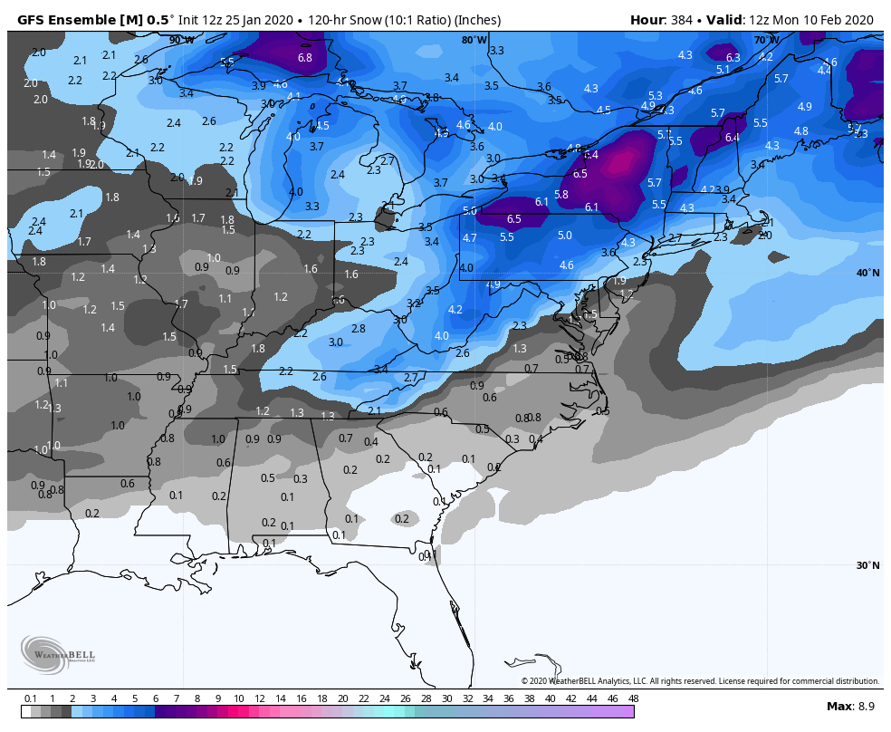
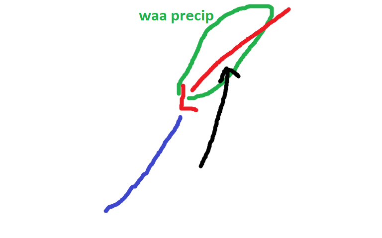
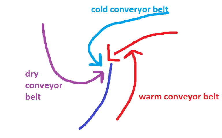
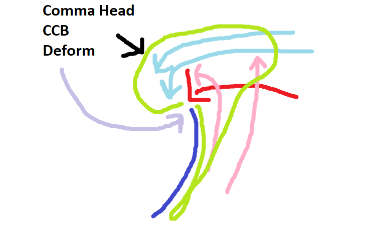
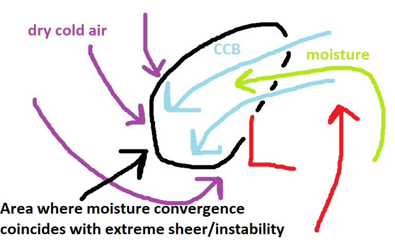
@Maestrobjwa CCB refers to the cold conveyor belt. I think to fully explain this I should do a quick overview of how most mid latitude cyclones work First of all low pressure typically forms along the boundary of cold and warm air...as air moves across the boundary to try to bring equilibrium to the imbalance. This movement of air creates lower pressure where the air is vacating faster than it is filling in. A low can really intensify when an area of divergence in the upper levels crosses over the surface area of lower pressure. These areas of divergence are typically found in front of either long-wave troughs or Rossby waves or smaller shortwave troughs embedded in the flow. This divergence aloft creates lift below it to "fill" the void and this lift (rising air) from the surface lowers the pressure as the lift outpaces the rate air is filling the surface void. On top of that the rising air cools and condenses causing precip but that process creates latent heat release which causes more lift (warm air rises). This creates a feedback loop that intensifies low pressure. Early in the life cycle of a developing low pressure area they are typically just waves along the temperature boundary Precipitation breaks out along the boundary where the flow ahead of the developing low pressure begins to cross the "boundary" to the north of the wave. The warmer air crossing the boundary has to rise over the denser colder air and this lift creates WAA (warm air advection) precipitation. (rising air cools and condenses creating precip) Showery precip usually exists along the cold front to the south of the low where cold air is undercutting the warmer air cause it to rise...but since this displacement happens much faster the precip there is sometimes more intense (thunderstorms or convective showers) but short lived. Many waves never make it beyond this stage if there are factors inhibiting their intensification. But if a low can amplify and deepen it will develop a circulation at several different levels As it develops this structure...the cold conveyor belt begins to bring moisture that is to the east of the low from the warm conveyor belt to the west of the low. As this happens the storm will begin to develop the classic comma head structure seen below. That precip to the west of the low track is often commonly called the "CCB" since it is a function of a healthy system developing precip in response to the cold conveyor belt transport of moisture west of the low track. Additionally the precip to the west of the surface low track is not driven by WAA as much as other forces and so can have a colder thermal profile, especially in marginal events. Seen above there the dry conveyor belt begins to cause the "dry slot" that you often get near the track of the surface low pressure. Below I have zoomed in on what is going on in the "CCB". This region in the "CCB" develops a deformation zone...a region where the atmosphere is being pulled in different directions at different levels. The convergence of the DCB, CCB, WCB, as well as the sheer at different levels created by the mid and upper level low pressures creates instability in this area. Where the moisture convergence from the CCB bringing moisture in off the WCB meets this instability you can get intense snow bands. This is what they call the "deform" band. One of the best examples of a deform band was from the February 2006 storm. This radar is from the NYC area but this same band impacted our area...I think the Columbia MD area got 20" because they were under this band for several hours. You can see on the radar loop the forces I described above at work. Later in the life cycle of a mid latitude cyclone, because the cold air often outpaces the advance of the warm air...the cold catches up and the low ends up cut off from the warm air advection...at this point we say it has occluded and it looks like this. At this stage the intensification period is over and the storm typically begins to weaken. But during this stage you can often see snowfall wrapped up even under the surface low instead of displaced to the NW of it. Hope this helped some. You can ask any follow up questions also...others feel free to add anything to this.
-
Mid January/Mid February Medium/Long Range Discussion
psuhoffman replied to WinterWxLuvr's topic in Mid Atlantic
I will add some stuff about that to the climo thread now -
Mid January/Mid February Medium/Long Range Discussion
psuhoffman replied to WinterWxLuvr's topic in Mid Atlantic
@Bob Chill guidance is off by a few degrees on the overall thermal profile from this range A LOT... usually with a typical airmass in winter the track is more important and that is what we are focused on...and in the end that might be true here also...but it's not at all crazy to think this ends up slightly colder than the guidance things from 7 days away...and if it does suddenly those "perfect track rains" become some big snow solutions. I know last November...from range that snow up here looked like rain...and actually the track ended up even worse but the whole airmass trended colder at the end and that made a huge difference. I can think of plenty of other examples. It could just as easily trend warmer and we end up with no prayer but odds are the guidance won't be dead on accurate with the temps at this range and we only need a SLIGHT adjustment colder...so really its a 50/50 shot we get that one factor to go our way. We would then be back to worrying about track and phase and all the other multitude of factors that can lead to a fail. -
Mid January/Mid February Medium/Long Range Discussion
psuhoffman replied to WinterWxLuvr's topic in Mid Atlantic
models wont often pick up on a 1-3" thump on the back end from 7 days out -
Mid January/Mid February Medium/Long Range Discussion
psuhoffman replied to WinterWxLuvr's topic in Mid Atlantic
It's why if I ever move to a "snowier" climate it probably would be NH over Colorado... I am sure I would be happy in Colorado... but NH can still get massive coastal storms and there is nothing like watching the storm develop and bomb out and looking at radar as the banding heads towards you...or waiting for the pivot... I just don't think I can give that up permanently. And Wildcat/Sugarloaf/Sunday River are "good enough" where if they were close bye and I could catch every powder day I think I would do ok just heading out west once a year... but I would be too bummed out missing every east coast storm ever. -
Mid January/Mid February Medium/Long Range Discussion
psuhoffman replied to WinterWxLuvr's topic in Mid Atlantic
Yea but I’d toss the next 2 weeks to have it look like this Feb 10th yes I know that’s not going to happen but if your going to take the first 15 days verbatim then you can’t toss the 16th. -
Mid January/Mid February Medium/Long Range Discussion
psuhoffman replied to WinterWxLuvr's topic in Mid Atlantic
Depends if you consider low to mid 30s “cold”. -
Mid January/Mid February Medium/Long Range Discussion
psuhoffman replied to WinterWxLuvr's topic in Mid Atlantic
Yea if that was actually right we get a 33-34 degreee 6-8” wet paste job. The Eskimo Joe special. -
Mid January/Mid February Medium/Long Range Discussion
psuhoffman replied to WinterWxLuvr's topic in Mid Atlantic
5-10”? Been a long time. The January 2011 storm kind of did that. But the front end was very dry and the airmass wasn’t as bad as this. But I wasn’t really thinking heavy rain to 5-10”. First our best bet is if the phase/close of the upper low happens at just the right time. We don’t want this slowly crawling up the coast. If we get a late capture so that the mid levels don’t get wrecked too bad then 2-4” maybe 3-6 NW of 95 isn’t crazy. Not likely but not unheard of. There was a storm in early January 1994 in Nova that started really warm with rain then flipped to 2-3” of snow on the back side with the deform band. There was a storm in Dec 95 like that too. That’s a more realistic goal imo. Even that’s a long shot but not as improbable as getting the unicorn scenario we need to get a 6”+ storm from this. -
Mid January/Mid February Medium/Long Range Discussion
psuhoffman replied to WinterWxLuvr's topic in Mid Atlantic
Any prolonged WAA precip in front is doomed. But this run CCBd us to death. It was just 2-3 degrees too warm. We simply need that to be an error. -
Mid January/Mid February Medium/Long Range Discussion
psuhoffman replied to WinterWxLuvr's topic in Mid Atlantic
The gefs really likes that period. The losetoa6 storm after the storm window. Again using a snow mean is lazy but you can see from the 5 day mean day 10-15 that it’s agreeing with what you have in mind. one last thing..the danger the pattern retrogresses after and the trough pulls west is real if the pac ridge flexes. However it’s a quick flip back to having a shot when the pac ridge relaxes if the HL actually flip like guidance suggests. Even the “oh no” trough back west look day 16 on the gefs is way closer to a workable progression after than where we’ve been all winter. I’ll mark today’s 12z runs in the win column for now. I liked more than I didn’t like.
-
Mid January/Mid February Medium/Long Range Discussion
psuhoffman replied to WinterWxLuvr's topic in Mid Atlantic
Yea but at least the treadmill didn’t flip over and crush us to death...yet. -
You just described exactly what I had in mind.
-
Mid January/Mid February Medium/Long Range Discussion
psuhoffman replied to WinterWxLuvr's topic in Mid Atlantic
One thing that could save us and it actually would be playing unti typical model bias...is if the upper low closes off and phases further north. None of the vorts even the NS ones have any real cold to work with. But you can see there how right after the initial phase of the STJ and “kinda” NS vort it did create some cold during the amplification phase down in the south. Get that phase and closing off of the upper low to haven over Western NC into VA and we win. That one run of the euro yesterday did that. I’m ok seeing the h5 low too far south at day 7. That actually could work out for us. Still need everything else to go right though. I’m trying to find reasons for optimism. -
Mid January/Mid February Medium/Long Range Discussion
psuhoffman replied to WinterWxLuvr's topic in Mid Atlantic
When and what phases is the hardest thing models can figure out so today is still a win I agree. Today increased the odds some. Mire trended good than bad. If the southern energy doesn’t split and ejects whole that would be the best scenario (I think that’s what @Bob Chill is saying too). Get a healthier stj wave in faster before the mediocre to begin with airmass rots not needing the NS complications. -
Mid January/Mid February Medium/Long Range Discussion
psuhoffman replied to WinterWxLuvr's topic in Mid Atlantic
Across guidance (gefs,geps, op euro) I think there was more good than bad 12z. The bad was too much stj getting left behind in Baja. That makes things too NS phase dependent. But other changes were positive. There’s a trend towards lower heights around the 50/50 space. The NS look trended better imo. Chances slightly improved imo. Still not likely but slightly better. After that I discussed a possible window day 10. It’s there. After that I’ll say this hopefully. The NAM looks to flip across guidance. Yes the hints are it dumps the trough out west. But if we get a NAM reversal it at least gives us a shot. Day 15 could be wrong with the exact trough location. The pac ridge could relax enough to shift the trough east at times. But at least cold can get into the mid latitudes in that look. -
Mid January/Mid February Medium/Long Range Discussion
psuhoffman replied to WinterWxLuvr's topic in Mid Atlantic
It’s depressing because way more went right then wrong that run and it still was mostly a fail. Even a 987 perfect track slp didn’t work because the initial 2 vorts phases and the upper low closed off too soon and then the NS didn’t phase in time. We need everything to go so perfect to win. -
Mid January/Mid February Medium/Long Range Discussion
psuhoffman replied to WinterWxLuvr's topic in Mid Atlantic
Even so 987 east of the Delmarva and everyone east of the blue ridge mixes anyways. Phase happened too early.