psuhoffman
-
Posts
26,285 -
Joined
-
Last visited
Content Type
Profiles
Blogs
Forums
American Weather
Media Demo
Store
Gallery
Everything posted by psuhoffman
-

Mid January/Mid February Medium/Long Range Discussion
psuhoffman replied to WinterWxLuvr's topic in Mid Atlantic
cause I know how much you all crave it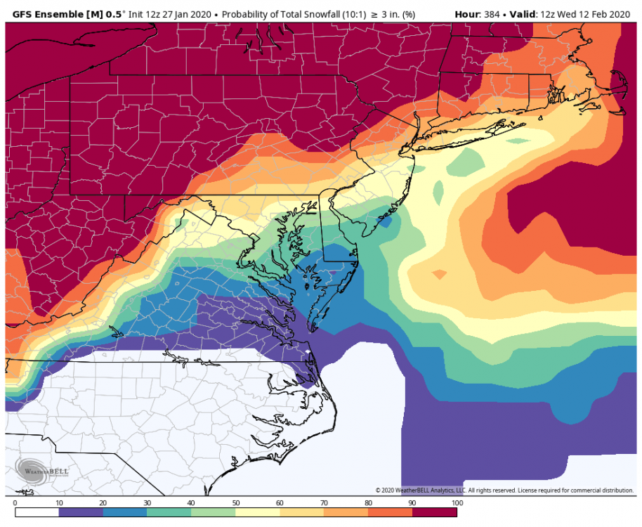
-
Mid January/Mid February Medium/Long Range Discussion
psuhoffman replied to WinterWxLuvr's topic in Mid Atlantic
problem is there will likely be a few days of dead space behind it also... there could maybe be a little NS vort diving in behind if it ends up not phasing that could bring a clipper type snow. That kind of thing wouldnt show up at range...but Ive seen hints that is possible. But other then a fluke type thing like that...after the weekend we have to wait for the dump of cold getting ejected out of AK. As that presses down into the midwest there will be the natural see saw effect on the longwave pattern and we will ridge here so that first wave will most likely go to our north...maybe so far to our north we don't even get any precip from it. It's after...later that next week that things could get interesting starting with the chance at a trailing wave along the front and then see if the STJ wants to play nice after that. -
Mid January/Mid February Medium/Long Range Discussion
psuhoffman replied to WinterWxLuvr's topic in Mid Atlantic
It wont...but no matter what happens this weekend was always and still is a very low probability proposition. After that we ridge out for a couple days as the initial dump of the AK cold airmass comes into the midwest. So barring some crazy good luck with this weekend thing...we likely are going to have to hope the very good pattern look after Feb 5th is correct and we can score something. Frankly odds wise our chances of snow remain about the same from Feb 1 through March 10th...then go down very dramatically after that. We still have some time to at least save something out of this dreadful winter. -
Mid January/Mid February Medium/Long Range Discussion
psuhoffman replied to WinterWxLuvr's topic in Mid Atlantic
In the past when you would look at a setup that is 48 hours away...and you break down our odds of this or that based on the barometric pressure... you are using the guidance. Otherwise you would have no freaking idea exactly what our barometric pressure would be in 48 hours...or what the pressure at Pittsburgh would be...or anywhere else. Your tools and application of very sound methodology are great...but they would have absolutely no predictive worth beyond about 24 hours without NWP because its impossible to extrapolate the atmosphere very far out in time without the aid of computers. Some of the best minds used to try back before NWP and it was mostly a disaster of busted forecasts. -
Mid January/Mid February Medium/Long Range Discussion
psuhoffman replied to WinterWxLuvr's topic in Mid Atlantic
Thanks for rewording my sentence. -
Mid January/Mid February Medium/Long Range Discussion
psuhoffman replied to WinterWxLuvr's topic in Mid Atlantic
you might be trending towards a meltdown if we don't get some snow soon -
Mid January/Mid February Medium/Long Range Discussion
psuhoffman replied to WinterWxLuvr's topic in Mid Atlantic
Are you assuming they won’t show higher odds when we actually do get a good pattern? -
Mid January/Mid February Medium/Long Range Discussion
psuhoffman replied to WinterWxLuvr's topic in Mid Atlantic
Yea but if we look at the pattern for the whole 15 day period that map covers...it is about "normal" The first 7 days are god awful for snow...with some lottery ticket super phase bomb scenario being the only chance, then after that a warmup as a trough dumps into the central US initially...then it gets good day 10-15...but only 5 of the 15 days have a good pattern...the other 10 are crap...so overall that washes out to about an "average" chance of 3" and since for that period you probably get 3" about 50% of the time...that seems about right...I would say that probability fits the pattern I am looking at pretty good. I think those probability maps have actually been about what they should be given the patterns...so not sure what all the fuss is about. -
Mid January/Mid February Medium/Long Range Discussion
psuhoffman replied to WinterWxLuvr's topic in Mid Atlantic
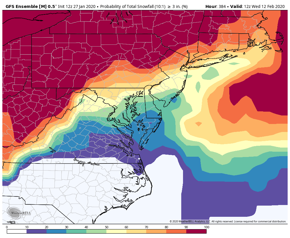
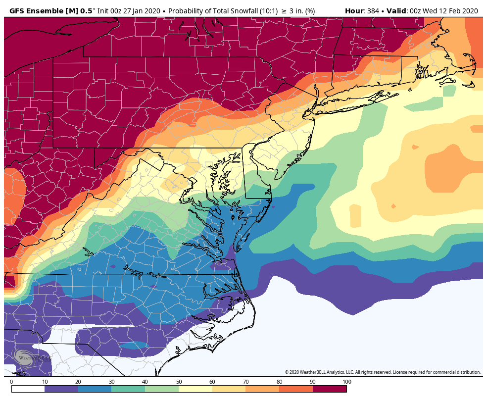
They have looked very similar a LOT lately because we have spent a LOT of time in the same general pattern (SUCK) lately. But we have had times when we are above 80% on those probability maps (other then when there is a storm like right in front of us and its 100% but that is like DUH) but those were typically periods when we were legitimately about to get slammed like in 2014 or from range before January 2016. I also think there were some pretty good looking probability maps before the run we had in Late Feb into Mar 2015. I also remember seeing some pretty good probability maps when the blocking started in March 2018.. and guess what...all those were times where we actually DID snow. But like I pointed out above 80% of the time in the winter we do NOT get 3" of snow in a 15 day period so if those maps are close to accurate...80% of the time they SHOULDNT show a high probability of snow. So yes MOST of the time they will look pretty sucky because most of the time our snow results will be pretty sucky. The rare times when a legit good pattern is coming you will see those probability maps increase. Look at the one I posted from last night. If we start to see maps like that for multiple runs (with above 50% prob) on the GEFS/GEPS/EPS then we know our odds are improving and that is useful. ETA: I am not saying a snow mean or probability map is the best way to analyze the pattern but those maps have SOME limited usefulness in terms of getting a general sense of what the guidance thinks our odds are in the next 2 weeks. Thats all... -
Mid January/Mid February Medium/Long Range Discussion
psuhoffman replied to WinterWxLuvr's topic in Mid Atlantic
They are serving a purpose though...they have been telling us our chances of snow are not good...and guess what...they havent been. When/if the pattern gets better those maps will show a better probability. Just because its depressing to see that our chances suck everyday doesn't make the information useless. However... @Weather Will I have noticed that over the last couple weeks...when we get the rare good run of a model somehow you forget to post that...its not fair to post all the dreadful ones and then not post when something good pops up...like last nights 0z GEFS run which was littered with hits day 10-15. I know 6z backed off but if we start to see more runs like this it could be a sign that our prospects are improving..especially since the look coincides with a better h5 pattern being progged.
-
This isnt a new problem... from Dec 1996 to March 2002 DC only had 2 snowy weeks in 6 years... lat January 2000 and March 1999. Other than that the entire 6 year period was a snow wasteland. There are even worse periods of futility than that.
-
The background base state has SUCKED since mid December... so all of these "threats" have been like buying a powerball ticket then getting excited for the drawing... I will say this...the pattern coming up in February is actually better. It's not the best pattern ever but its legitimately less hostile to snow. We have to see if that continues to progress closer and doesn't "degrade" but if that look ends up real then we could get some shots that aren't full court buzzer beater odds.
-
Mid January/Mid February Medium/Long Range Discussion
psuhoffman replied to WinterWxLuvr's topic in Mid Atlantic
They actually do have "SOME" usefulness but the issue is they highlight how much we suck at snow and no one wants that thrown in their face EVERYDAY. But they do show what our chances are with respect to "climo". Problem is...when the mean shows about 30% chance of snow over 15 days...especially when it all comes in a 5 day chunk...that is actually an above normal chance of 3" of snow for DC. I broke down the period from Dec 1 to Mar 15 into roughly 15 day chunks... I basically split each month in half... doing that gives us 210 roughly 15 day periods...and DC got 3" of snow 42 times in those 210 periods...so that is about 20% of the time. So when we have a 30% chance of 3" of snow that simply tells us we have a slightly better than normal chance at 3" of snow. When we see those means get up above 50% that is REALLY good compared to avg. Problem is our average is no snow...80% of the time we go a 15 day period in winter without 3" of snow so...that is just normal. But we do sometimes see that mean near 0% and that tells us its almost a no hope shut out the lights pattern the next 2 weeks... and we get a lot of those. Here is the breakdown in terms of DC odds of seeing 3" of snow during a period in the last 30 years Dec 1-15 13% Dec 16-31 6% Jan 1-15 13% Jan 16-31 33% Feb 1-14 27% Feb 15-28/29 23% Mar 1-15 23% -
Mid January/Mid February Medium/Long Range Discussion
psuhoffman replied to WinterWxLuvr's topic in Mid Atlantic
@frd that GEPS day 16 I posted as a joke does look like what you would get if you mashed phase 2 and phase 6 together in February... We need to hope that the phase 6 wave relaxes enough to let the IO forcing become dominant at times. My guess is if they both offset we get a blah pattern...not totally god awful but probably not good enough. What doesn't help is I suspect the mjo pac forcing is more strongly correlated to our pattern than the IO forcing...I would rather a favorable wave in the PAC phase 8/1 offsetting an unfavorable one in the eastern IO than the other way around... -
Mid January/Mid February Medium/Long Range Discussion
psuhoffman replied to WinterWxLuvr's topic in Mid Atlantic
My guess is if we don't get cold it will have to do with the IO forcing being offset by the unfavorable forcing in the west pacific where convection continues to want to reform around phase 6. -
Mid January/Mid February Medium/Long Range Discussion
psuhoffman replied to WinterWxLuvr's topic in Mid Atlantic
Yep...that period continues to hold promise. But let’s say we don’t get lucky in that window...and it goes to this... -epo,-AO, -NAO and a raging southeast ridge lol. That looks like the conflict beteeen the dueling convection in the IO and west pacific. We get the high lat response of the IO wave but also the Se ridge of the pac wave. That would be the final kick to the Nads from this winter! i suppose on the optimistic side if the se ridge gets suppressed in that look it sets up a prettt epic boundary wave pattern -
My impression is they take themselves a little too seriously. But to each their own. I like it here.
-
Can something bust if we never expected anything? Bob said it yesterday... we keep forcing “threats” because we’re bored but we know these are all lottery ticket odds.
-
Mid January/Mid February Medium/Long Range Discussion
psuhoffman replied to WinterWxLuvr's topic in Mid Atlantic
Maybe. Trying to figure out specific details of NS vorts in a progressive flow is difficult at 48 hours. At 6 days forget it. -
Mid January/Mid February Medium/Long Range Discussion
psuhoffman replied to WinterWxLuvr's topic in Mid Atlantic
If it’s goinf to work it almost has too phase with one of them clean. There is a train of NS shortwaves flying across keeping the flow flat over top of it. Unless it hitches it’s wagon to a NS wave that digs enough to capture its in trouble. Perhaps if the stj wave ejected whole but the ships sailing on that and its circular thinking. The progressive flow shearing the top of the stj wave is what causes the reaction of the wave stretching and leaving too much energy behind in Mexico. -
What happened?
-
Mid January/Mid February Medium/Long Range Discussion
psuhoffman replied to WinterWxLuvr's topic in Mid Atlantic
Context matters 1. It’s been awful 2. everyone is having fun with it 3. Everything is still a loooong ways out 4. No one is being a jerk or antagonizing anyone 5. No one is going overboard and trying to intentionally derail the thread. If people go too far and it turns ugly then moderation is needed. I’m not in favor of heavy mod. But in the past we have had a few people who didn’t have any concept of boundaries or common sense. Or they were intentionally trying to troll the thread over and over. -
Mid January/Mid February Medium/Long Range Discussion
psuhoffman replied to WinterWxLuvr's topic in Mid Atlantic
He will complain if that does verify that 15” over 4 days is lame and it should have been 30” -
Mid January/Mid February Medium/Long Range Discussion
psuhoffman replied to WinterWxLuvr's topic in Mid Atlantic
HH delivers. seriously screw next weekends puke airmass phase needing garbage storm. I’ll sign up for week 2 of the gfs and call it a winter! No regrets. Give me the contract right now. My pen is ready. -
Mid January/Mid February Medium/Long Range Discussion
psuhoffman replied to WinterWxLuvr's topic in Mid Atlantic
There were major differences but simply in terms of the play we need between streams a similarity to dec 2009. That was undecided until 72 hours. The Canada ridge is creating a similar effect on the storm track as the NAO block did in 2009. Obviously the NAO block created a much better temp regime though. The Canadian ridge with a +EPO/NAO combo is a much warmer pattern. But the pna ridge axis is similar and the issues with needing some northern stream help to amplify a wave along the coast is similar. It’s a much trickery setup than something like Jan 2016 or Feb 2010 when you have a strong stj wave and a broad full conus trough and no NS in the way. This requires interaction between multiple moving parts. It won’t be resolved as easy at range. I am not comparing the snow potential to any of those systems just the storm amplitude and track. Truth is if we had real cold we would have some HECS potential. The guidance that does phase really goes crazy. Still don’t favor that. But even if we get the phase unlike Dec 2009 we could still fail because of the awful airmass.