psuhoffman
-
Posts
26,285 -
Joined
-
Last visited
Content Type
Profiles
Blogs
Forums
American Weather
Media Demo
Store
Gallery
Everything posted by psuhoffman
-
It’s our fault. That’s obviously what viewers want to see or they wouldn’t be doing it.
-

Mid January/Mid February Medium/Long Range Discussion
psuhoffman replied to WinterWxLuvr's topic in Mid Atlantic
It’s the previous 6 hours precip rate. -
No joke many years ago I flipped on Fox and Friends accidentally having never actually watched it and I thought it was a parody. The way they were “acting” and exaggerating their expressions and reactions so over the top...then I realized it was REAL and it was a depressing sobering moment. Not for any political reason. I don’t think the segment was even political. Just that it was so transparently fake yet so many people liked that kind of “news” production. I don’t think CNN lately is any better.
-
Kinda...except honestly whenever it’s a borderline temp issue it almost always ends up breaking good up here. So I get the excitement of the suspense but with a payoff. If I was in the city I’d want cold smoke every time. But those really cold waves tends to be hours of light to moderate snow. I do enjoy when it’s puking heavy wet snow bombs up here more. Some of my favorite storms here weren’t the numerous 2’+ storms but just a good 6-10” wet snow paste job like October 2011 or the early Dec 2009 storm, not the big one, or the Feb 2016 storm that was a 33 degree 7” snowstorm up here. November 2018 would have been higher on my list except I was stuck in Baltimore and didn’t get home until the snow was ending. That sucked. I also missed some of the really heavy wet snow that fell the first day of the 2 day 14” March 20-21 2018 storm. The second day was colder dry snow but the first day was 8” of really heavy wet snow but I only caught the last hour of the good rates.
-
Mid January/Mid February Medium/Long Range Discussion
psuhoffman replied to WinterWxLuvr's topic in Mid Atlantic
They simply use the output of each member to calculate odds. Eps is less jumpy because it has more members and more spread typically. Gefs is underdispursed. NCEP is aware of it. The whole system is being changed to operate off the new FV3 core soon. I’m not sure an index probability would be better because the index is based off the individual members output. And their results are impacted by that too. We only know what the indexes are now. (Bad just in case you weren’t sure) but we don’t know in 5/10/15 days...those estimates are based off the models so can be just as wrong. There are some pattern analog progression models but they don’t seem to be any more reliable because patterns often evolve different based on different factors. There are SST long range models but they mostly busted BAD last year and this year. I don’t blame them...I busted both years because I tend to lean heavily on SST analogs for long range and lately the correlations are failing. I need to look more into some of the methods Anthony and Tom use wrt angular momentum, walker cell strength. Those correlations seem to be more important that canonical sst anomalies in a changing climate where waters are in a warmer state. I know HM busted this year but he has stated that was partly because he broke some of his own rules this year. Everyone makes mistakes! -
I’ll admit I agree with @Ji on one thing. Missing a heavy wet snow is depressing. That is my favorite. When we snow at 32* and it’s paste that sticks to everything and perfect for making a snowman or fort with the kids. Of course the problem is for me to get a wet snow is invariably has to be raining in DC. Not that I’ll kick the idea of 8” of cold smoke on the gfs out of bed but those kinds of storms always have less suspense and excitement.
-
Mid January/Mid February Medium/Long Range Discussion
psuhoffman replied to WinterWxLuvr's topic in Mid Atlantic
-
Mid January/Mid February Medium/Long Range Discussion
psuhoffman replied to WinterWxLuvr's topic in Mid Atlantic
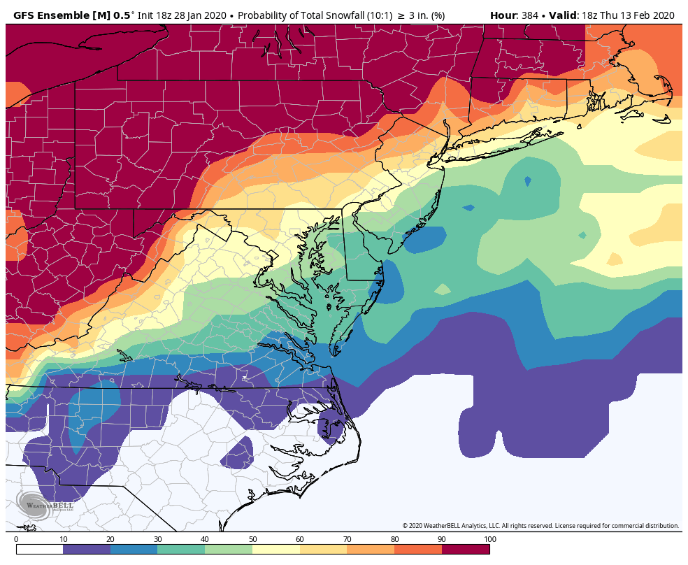
You’re welcome. You weren’t interpreting it wrong. It means exactly what it says. The DC area is between the 50-60% chance of 3”. Is what it is. I’m just adding historical context. The fact that it’s all in a 5 day window though actually does make it more impressive. It’s not from a shotgun effect of 5 or 6 low level threats over 15 days. That’s typically a not so good thing. Additionally, I know it being 10 days away sucks but seeing that high probability for events that are 9+ days out is actually impressive. It’s hard to get high odds at that range, for obvious reasons. Keep in mind that map is very course and won’t pick up local meso scale features like elevation well. You are way closer to the 60 than the 50 so you are likely about 58 or 59% and maybe more since you have some oragraphic help. DC is probably about 52% guessing from that map. -
Mid January/Mid February Medium/Long Range Discussion
psuhoffman replied to WinterWxLuvr's topic in Mid Atlantic
Well there is absolutely nothing the first 7 days...so it’s really a 50% week 2. And that’s above climo. Avg chance of 3” of snow during that week is about 25%. Is it the best probability map I’ve ever seen no. But it’s better than those weeks of 10-20% -
Mid January/Mid February Medium/Long Range Discussion
psuhoffman replied to WinterWxLuvr's topic in Mid Atlantic
This is the one they want
-
Mid January/Mid February Medium/Long Range Discussion
psuhoffman replied to WinterWxLuvr's topic in Mid Atlantic
That looks too much like 2014-15. I want hecs Deal with it -
Mid January/Mid February Medium/Long Range Discussion
psuhoffman replied to WinterWxLuvr's topic in Mid Atlantic
I get fringed so you know it’s real. -
Mid January/Mid February Medium/Long Range Discussion
psuhoffman replied to WinterWxLuvr's topic in Mid Atlantic
Let it go. Incoming on 18z gfs. 1041 high on top of a stj wave train. -
That’s because we don’t believe in global warming...
-
Mid January/Mid February Medium/Long Range Discussion
psuhoffman replied to WinterWxLuvr's topic in Mid Atlantic
This is actually a very good look for getting progressive waves with cold around...this has worked before..the key is getting the SE ridge suppressed just enough. That can happen various ways...a well times TPB lobe rotating across to our north... a series of waves where the first knocks down heights, that was how we got so many waves in 2014 and 2015. It isn't an HECS look but it is a snowy one. The GEFS and GEPS not so much...so lets bank on the EPS dominance right now. -
So do it... talk about the long range weather however you want to talk about it. All you do is complain about what other people are talking about and how they are talking about it.
-
get to work
-
@RevWarReenactor You also were asking earlier about the odds for this year... There have been 12 prior years where DC entered February with 1" or less of snow. In those years DC recieved these totals the rest of winter. 0, 10.7, 1.7, .1, 8.9, 24.3, 3.1, 4, 7, 2.8, 28.6, 6.5. The mean of those years is 8.2" and the median is 5.8". Only 25% of those years did DC not get the 2.4" it needs to avoid your scenario so odds are against that. There have been 23 years where DC had 2" or less going into Feb. The mean of those years was 7.8" and median 6.5". Only 26% of the time they didnt get the 2.4" the rest of the way. There have been a few fluke times where DC got slammed after going into February in a similar situation as now. But odds say the most likely result is DC gets somewhere between 4-9" the rest of the way...which will put this year into the just plain typically bad category but avoid the "worst snow period ever" thing you are using.
-
In the last 30 years DC has had 3" or more of snow between March 1-15th 23% of the time DC has had 3" or more of snow between Jan 1-15th 13% of the time. Those are just facts. Those averages are going to change...they do not YET take into account the last 10 years...and they still factor in the 1980's...When the 80s come off the books and the 2010s go on at the end of this year March will become snowier. We had a historically bad run in March during the last 30 year climo period. Additionally because the last week of January is VERY snowy and the second half of March is NOT...it skews the month of January snowier than March as a whole month. But the first half of March is snowier than the first half of January in terms of the odds of getting snow. Additionally there were some HUGE storms in January like 1996 that skew the "average" but that has nothing to do with the odds of simply getting a snowstorm. Truth is we have a higher chance of getting a snow in early march than early january according to recent results.
-
yea people can take it however they want...but last year with 16.9" DC had its 7th snowiest winter in the last 30 years.
-
Yes it has been below avg...I said you are exaggerating not that there is no truth...but you go from 0 to 60 with nothing in between ever. It's hard to answer how long because we just had an above average snowfall year LAST YEAR...and you seem to be tossing that aside like nothing. We recently had a 7 year stretch of below avg snowfall every year from 2004 to 2009. We had 6 year stretches from 1997 to 2002 and 1990 to 1995. So we have a LONG way to go to get to that level. As for your "4 year" thing... since this winter isn't over yet that is hypothetical only. If we get no snow at all this year...then yes this will be the lowest 4 year snowfall period ever. It means exactly what it means. But all that is showing is how our climo has changed. I think its a real trend that DC has a harder time fighting and scrumming its way to a decent snowfall total in "bad" years. The odds of us getting a snowy winter have not gone down...we still get a snowy winter on average 25% of the time. The difference is in the non snowy years...DC is more likely to end up with some god awful total like 3-5" than 50 years ago when DC would usually scrap its way to 10" or so even in a bad year. So because of that...when you measure a modern period that doesn't include one of those BIG 25% years...it is likely to be the "worst" ever because our snowfall is going down in non good years. 50 years ago a bad snow year in DC was 8" and today that same pattern would likely produce 3" because of the warmer base state today and the increased urban heat island effect. A lot of storms that would help DC get some snow in a bad year is just rain now. But that isnt the weather hating on you...its just our new normal.
-
Mid January/Mid February Medium/Long Range Discussion
psuhoffman replied to WinterWxLuvr's topic in Mid Atlantic
Yea except I am sure some clown will point out how it had that one run at day 9 where it bombed us with snow to show its crap and models suck blah blah blah -
Mid January/Mid February Medium/Long Range Discussion
psuhoffman replied to WinterWxLuvr's topic in Mid Atlantic
sorry...don't mean to be short. People are having melt downs over very op run fluctuation...going crazy over a threat this weekend we KNEW was very very very low odds to begin with... jumping to conclusions before the whole model suite including ensembles comes in... over reacting to things that weren't even a big deal. That wave next week was ALWAYS a cutter...every run of every model took it way north of us for the last 5 days yet suddenly today people started making a big deal about that for some reason???!!! Worrying about a shift on an op run at day 9... everyone is acting full tilt right now because it hasn't snowed. -
Mid January/Mid February Medium/Long Range Discussion
psuhoffman replied to WinterWxLuvr's topic in Mid Atlantic
My post is not specific to the CMC. -
Mid January/Mid February Medium/Long Range Discussion
psuhoffman replied to WinterWxLuvr's topic in Mid Atlantic
Trust me...we want it south on the GFS at this range...its been too cold all winter at range. If the euro goes suppressed consistently then I will worry a bit more...still not much at that range. The EPS is all over the place shotgun style right now with that storm.