psuhoffman
-
Posts
26,285 -
Joined
-
Last visited
Content Type
Profiles
Blogs
Forums
American Weather
Media Demo
Store
Gallery
Everything posted by psuhoffman
-
Y’all complained when those maps showed 20-30% everyday. That’s what you get!
-
No one needs to be defensive. Everyone is free to feel however they want. And it’s not like I’m totally thrilled about this. Im just trying to lesson the misery. Serenity now and all that jazz.
-
3 points to consider 1. I highly doubt we suddenly had a radical climate shift. We’ve had periods like this before. 1948-1953 was awful. There was an awful run in the mid 1970s. 1989-1992 was mostly crap and so was 1997-2002, 2007-2009, and 2011-2013. Also look at a long term NAO chart and you will note it runs in cycles with multi year positive and negative phases. Also note there are typically positive cycles preceding solar minimums and negative cycles following them. We are about to hit a solar minimum so it’s not crazy that we have had a multi year positive. It’s also not crazy that we had a rough patch for snow following what was an epic 3 year heater. If we go another 3/4 years without any winter -NAO then I might start to worry. Right now this is still within historical norms. 2. I showed a while ago that we have had patterns like this before and how bad they all sucked. It’s not like this type of winter never happened before or we used to snow a lot in this pattern. I do think DC is losing some marginal events and that what was a 6” year 50 years ago might be a 3” year now. So bad years are even worse maybe. But I don’t thInk the odds of a really good year have changed appreciably. If we start to see what should be good patterns not working because it’s too warm that would be a red flag. This pattern always sucked. 3. What if your fear is right. What if we did flip and it’s never going to snow here much anymore? Will getting upset every 6 hours when the gfs doesn’t show snow change anything or make it any better?
-
I was reading some old storm threads from years ago and it struck me how many voices are missing. And I don’t think it’s just because things have sucked. I went back to other years that sucked and posters like HM/Ian/Matt/Ender/Wes and many others were contributing in discussions even when things weren’t doing amazing. And lately even when we do get a legit threat most of them barely even pop in at all. I wonder what happened and I really hope it’s not a trend. It’s been such a slow bleed that I hasn’t even realized it until I went back and saw what the threads years ago looked like.
-

Mid January/Mid February Medium/Long Range Discussion
psuhoffman replied to WinterWxLuvr's topic in Mid Atlantic
No I was pretty pessimistic late summer early fall. I meant more in November. I thought by then things looked “ok”. Never great but years with a mish mosh of mediocre that were warm neutral enso in the past tended to be ok. I got that part way wrong. -
Mid January/Mid February Medium/Long Range Discussion
psuhoffman replied to WinterWxLuvr's topic in Mid Atlantic
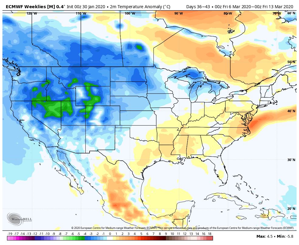
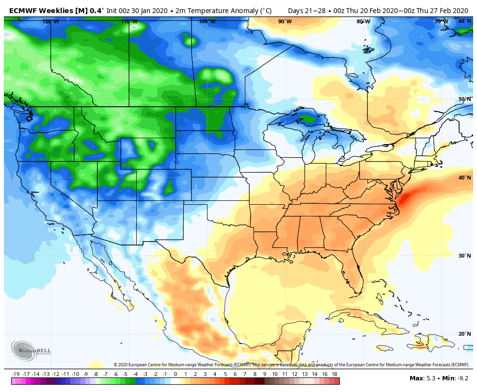
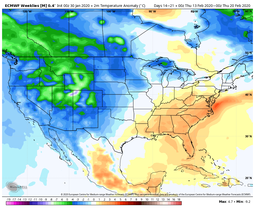
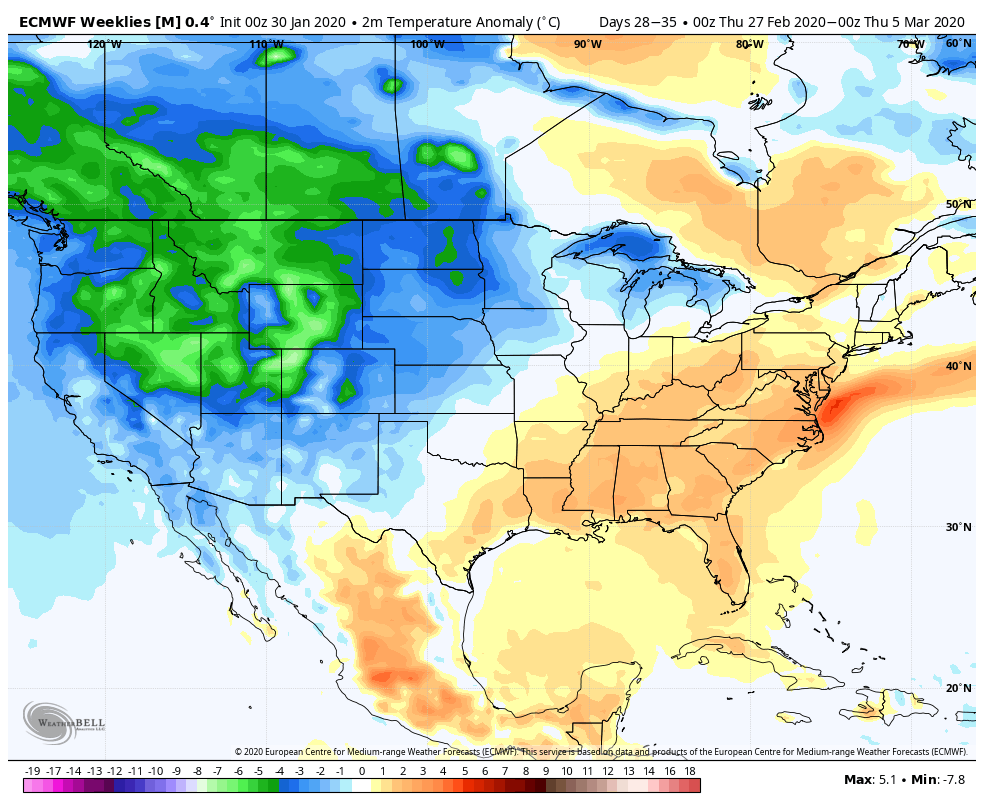
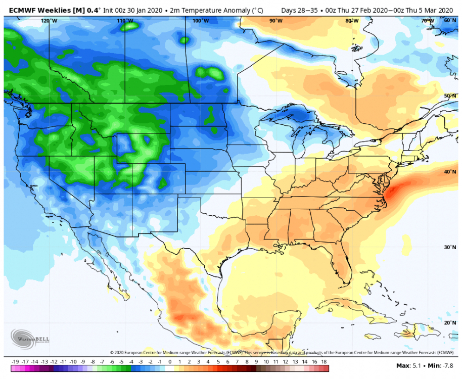
Weeklies week 3 week 4 week 5 week 6 but they flip the pattern around March 15 so we can enjoy a cold miserable spring!!!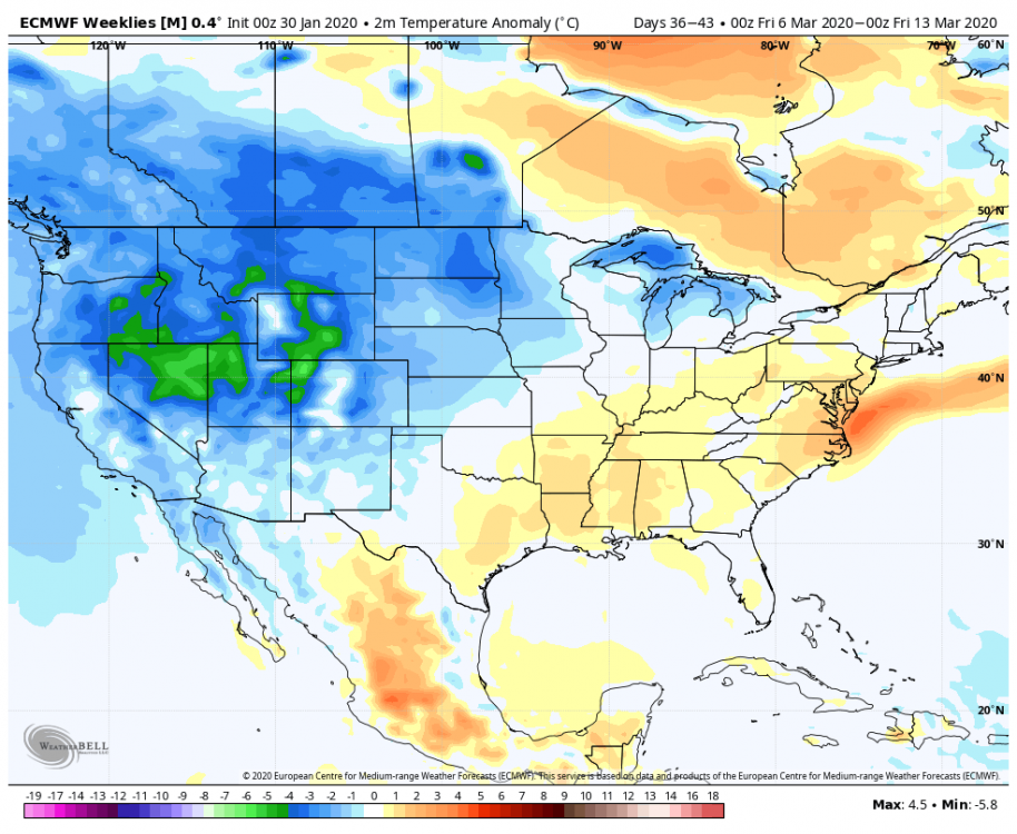


-
Mid January/Mid February Medium/Long Range Discussion
psuhoffman replied to WinterWxLuvr's topic in Mid Atlantic
It’s ok even if I don’t get another inch I’ll be alright. -
Mid January/Mid February Medium/Long Range Discussion
psuhoffman replied to WinterWxLuvr's topic in Mid Atlantic
I agree guidance degraded that look. But didn’t I warn you about that a week ago? The way the pattern was progressing it was unlikely the canadien ridge was going to be able to do much damage to the tpv as it briefly traversed the edges of the NAO domain. And the ensembles always has some doubt built into the means. So yes the look changed but it did exactly what I thought it would so I guess I’m not lamenting it. -
Mid January/Mid February Medium/Long Range Discussion
psuhoffman replied to WinterWxLuvr's topic in Mid Atlantic
About 11” I think. I’d have to go into my records and add to all the minor events in Dec but I’m not doing that. Too depressing. But it’s close to 11”. -
Your last argument made more sense
-
Mid January/Mid February Medium/Long Range Discussion
psuhoffman replied to WinterWxLuvr's topic in Mid Atlantic
1. That’s an op at range. The ensembles never looked as good as that even but... 2. That’s not a true NAO block. That’s more of a WAR on roids, and it’s transient because... 3. There is no 50/50 there to help pump that ridge into the west NAO domain where we want it or to create confluence in the northeast. 4. The epo and pna ridges are displaced west of ideal It’s close to a good look but not. This is where we actually want those features centered. -
Mid January/Mid February Medium/Long Range Discussion
psuhoffman replied to WinterWxLuvr's topic in Mid Atlantic
Curious what you thought looked really bad in the fall. Turns out some of Tom and HMs insights wrt the walker cell state and AAM were right but purely from classical analogs that matched a weak neutral enso with descending qbo and a similar north pac sst config the results were ok. Not great but not like this. This turned out like a Nina. Tom nailed that. -
Mid January/Mid February Medium/Long Range Discussion
psuhoffman replied to WinterWxLuvr's topic in Mid Atlantic
It’s never happened. Using the local coop here back to 1989 then Westminster before that...back to 1942 the worst Feb/March combination was 2002 with 1.5” total. So no we probably won’t get blanked. But a lot of the analogs to this years pattern were the most dreadful years. 2002 is one. 1988 only had 2.6” from Feb 1 on from a bunch of insignificant cartoppers. Same in 1950. 2008 only has a couple 1-2” snows. So we will luck our way to some snow. That’s 99%. An inch here or there somehow is almost a sure thing. But honestly if we get 2” the rest of the way from a couple insignificant events I don’t care. Honestly adding 2” to my current total won’t make me feel any better. If it’s not going to be a legit snowstorm I’d rather just stay warm and get to spring. -
Mid January/Mid February Medium/Long Range Discussion
psuhoffman replied to WinterWxLuvr's topic in Mid Atlantic
I dunno I have a bad feeling the mjo is about to go ape into warm phases and slam the door on February after next week. But I just saw JB actually tossed in the towel and said the same thing after seeing the mjo forecasts and so now I have to reconsider my stance. -
Mid January/Mid February Medium/Long Range Discussion
psuhoffman replied to WinterWxLuvr's topic in Mid Atlantic
It was never really THAT good. The canadien ridge temporarily traversed the NAO domain for a few runs. It still does but it happens while we torch. But it’s way too transient to do any good or bully the pattern. It’s not a block. Just a weak transient ridge. The real issue is again the epo centers itself too far west setting up an RNA pattern. -
People are really driving themselves crazy looking at each run with expectations. I think I’m less frustrated right now because I got the disappointment out of the way a month ago. Back when I made the now infamous “winters over” post I was depressed about it. Not really, but in a this sucks a wasted winter sense. And I dealt with it. Then moved on. Now I don’t expect anything but suck. Every major global pattern driver is a train wreck. I watch just in case a fluke happens or a pattern change comes but I don’t expect anything to work out. So when it doesn’t I’m not distraught.
-
Mid January/Mid February Medium/Long Range Discussion
psuhoffman replied to WinterWxLuvr's topic in Mid Atlantic
It’s very rare to get under 20” here. Only happens about 10% of the time. But we’re due. Hasn’t happened since 2008 when there was only 19.2” here. 2009 barely got to 20”. -
Mid January/Mid February Medium/Long Range Discussion
psuhoffman replied to WinterWxLuvr's topic in Mid Atlantic
Wow why can't we get the front to clear from the midweek storm. That's most depressing thing I've seen this year Come on deep down you knew that’s exactly how it was going to look when a gradient pattern at day 15 showed up. How often do they actually work out here? 10% maybe. -
Mid January/Mid February Medium/Long Range Discussion
psuhoffman replied to WinterWxLuvr's topic in Mid Atlantic
The day 8/11 analog packages show what were up against. Only one significant snow event in all the analogs. Feb 67 which was one of the weirdest fluky storms of all the KU storms. So yea that could always happen but in general it’s not a winning look. -
Mid January/Mid February Medium/Long Range Discussion
psuhoffman replied to WinterWxLuvr's topic in Mid Atlantic
12z eps was a train wreck run. Nothing good about it. -
Mid January/Mid February Medium/Long Range Discussion
psuhoffman replied to WinterWxLuvr's topic in Mid Atlantic
The op euro is doing what the 18z GFS yesterday (to a lesser extent) did. That wave in the PAC is actually displacing the TPV off the pole and seriously impacting the HL pattern. That would work. But the problem is the vast majority of guidance is trending away from that. But I suppose it is far enough out...and coming during a period where this is "some" mjo phase 2 forcing, that MAYBE we get a temporary TPV disruption. Perhaps I am discounting that possibility too much. If so that would set up a more than "needs crazy good luck" period. I still doubt it would last long but we take what we can get. -
Mid January/Mid February Medium/Long Range Discussion
psuhoffman replied to WinterWxLuvr's topic in Mid Atlantic
There is nothing to make that happen... there is no blocking and the trough axis is way too far west. -
Mid January/Mid February Medium/Long Range Discussion
psuhoffman replied to WinterWxLuvr's topic in Mid Atlantic
@stormtracker The STJ wave has no mid or upper level support to wrap up, and also there is no high pressure to create a resistant flow to the southerly flow around the low or enough real cold air to create WAA lift. That inhibits a healthy precipitation shield. Without that the southerly flow simply displaces the air in the way. There is on real cold or resistant flow around a high to create the "lift" needed to get precip. -
Mid January/Mid February Medium/Long Range Discussion
psuhoffman replied to WinterWxLuvr's topic in Mid Atlantic
I planned a more in depth post after the 12z runs finished but I will probably be too busy later so i will just dump my thoughts now. There might still be a window where something is "possible" in the week 2 period but the season long pattern flaws of the +EPO/AO/NAO will continue. A very transient wave through the PAC NW ejects some cold into the CONUS though...and there are some signs a second wave could do the same, but any hopes of those 2 waves effecting a real change on the NAM state are pretty much dead. At range those 2 waves were severely weakening the PV...but the trend away from that has been steady and now neither of those waves even really makes much of a dent. They do at the least deliver some cold. But the trough axis is going to be too far west. To get anything to work it will take luck with taking up waves like the op GFS does. The best way would be to get a series of waves where the first wave draws a front through and a second wave follows close behind. We have lucked out way to some snow in a bad pattern that way before, but its going to take luck and not be something we can track from day 10. After that I have a feeling things get ugly again. It's easy to see where the MJO is heading... another high amplitude cycle through 4/5/6/7 is likely on the way. 7 is also a warm phase in Feb/Mar so we would have to wait until it gets through that whole rotation again to have a chance at a meaningful pattern flip. The feedback from those phases is likely to pull the pacific ridge back and pump the SE ridge in the kind of gradient TNH pattern we are looking at. I suspect this February will end up looking a lot like last February...except with a raging positive NAO instead of a neutral one. The timing of that next MJO rotation takes us into very late February or more likely March. If, and I have no confidence in this, the PV is more vulnerable at that time...that would be the next window to get a meaningful pattern change. Just in time to get 45 degree rain all spring.
-
Mid January/Mid February Medium/Long Range Discussion
psuhoffman replied to WinterWxLuvr's topic in Mid Atlantic
95-96 kinda makes sense in hindsight... It came during the period following a solar minimum where the NAO was biased negative for several years. Very favorable QBO. It wasnt a particularly strong nina and it was following a nino so there was probably some mixed signals wrt enso. A few years ago (when we were starting down a nina) I looked at snowfall results in all Nina years and I found that when the NAO is actually negative in a nina our snow results can be ok. The issue is that the pacific forcing in a nina favors a positive NAO and so MOST Nina years have a predominantly positive AO/NAO. But if we ever get the combination of a weak/moderate nina where all other factors (solar/QBO/previous enso state) strongly favor blocking to overcome the enso we could get another 1996. It actually wouldn't shock me if something like that happened in the next few years...provided the nina isnt strong enough to overpower the other influences.