

psuhoffman
-
Posts
26,285 -
Joined
-
Last visited
Content Type
Profiles
Blogs
Forums
American Weather
Media Demo
Store
Gallery
Everything posted by psuhoffman
-
The pv over Greenland is so expansive it creates a trough into the 50:50 region creating just enough confluence to our north to get a wave under us. It’s an odd setup. Odd usually doesn’t work out so don’t waste too much time worrying about it.
-
I never paid that much attention because I was 99% sure that had no chance. For a hot minute guidance was showing perfect timing between two waves and a lobe of the tpv dropping in front of the second wave to suppress it. That was so complicated I didn’t waste any time because there was little chance we would get all those moving parts to line up like that imo.
-
Anything “can” happen. It just probably won’t. Like asking why some player won’t hit a full court shot at the buzzer. Could he...sure. Will he...ummm The whole mid latitudes are warm all across the northern hemisphere. Fast progressive zonal flow. It would be the ultimate needle thread in a bad pattern. It’s unlikely. But flukes can happen. You should be asking how “could” it. I noticed the runs that had snow yesterday were creating a very odd anomalous setup in which the NAO became so positive that the PV expands down into the 50/50 space enough to create some suppression and there is just enough ridging across southern Canada that a discreet wave cuts across under. Now could that hypothetically physically possibly happen? Yes. But almost everytime we see a setup long range and say...that is really weird or convoluted it ends up not happening.
-
I don’t know why some have said the pac ridge hasn’t been a consistent problem. Just because it didn’t stay at +5 stdv the whole time it’s still been there pretty consistently since early December. Since Dec 1 and next 30 days on euro weeklies I guess I didn’t articulate my point that well though. When we see a very anomalous ridge there along with a very strong +AO in January it’s very likely both persist to some degree. That doesn’t mean both stay at crazy anomalous levels the entire time.
-
We already know what the truth is
-
There is a correlation. Plus while that PDB, as you call it, in January can shift and wax and wane the presence of a very anomalous ridge there at some point in January along with a +++AO strongly predicts a continuance of struggles in February also. You don’t get that strong combo without something to do with the background state forcing likely being hostile.
-
6.6” isn’t significant?
-
That look could have worked better in January. But the high latitudes are becoming a bigger and bigger deal as we get later in winter. If the NAO stays +++++ its going to be difficult to get a positive result without an east based epo ridge.
-
Everyone can root for whatever they want since it doesn’t actually affect the weather. So everyone can root for whatever they want without any guilt because there is no causality. Unless other people wanting cold or warm bothers you...in which case may I suggest you find something (and it shouldn’t be hard) more productive to worry about!
-
Different longwave reactions to the same forcing due to changing jet strength. That’s why the mjo phases don’t have the same reaction every month. It’s not all the time, it’s not even most of the time...but some of the similar pattern god awful winters flipped to a colder snowier period in March. Shorter wavelengths combined with the increased potential energy of extreme baroclinicity in March can lead to some wacky results that can overcome the crap pacific base state. It’s no guarante. Plenty of analogs to this winter simply rolled into spring but enough featured a March snowstorm to say that’s likely the best chance at a fluke.
-
Dec was different. Dec also can be a fake out before the jet settles into its winter longwave base stats. We were cooked in late December when the strong PV coupled with the troposphere. History suggests when the combination of a very strong central pac ridge and very strong +AO sets in during January it persists the rest of winter most of the time. That doesn’t mean there is a super pac ridge the whole time but a really anomalous ridge there is indicative a bad pac forcing. It’s a tell that we are fighting a hostile base state. Add in a +AO and we’re toast.
-
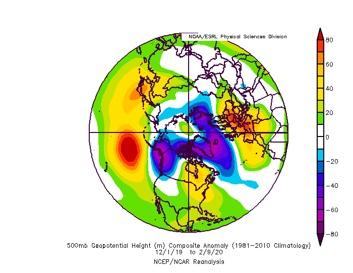
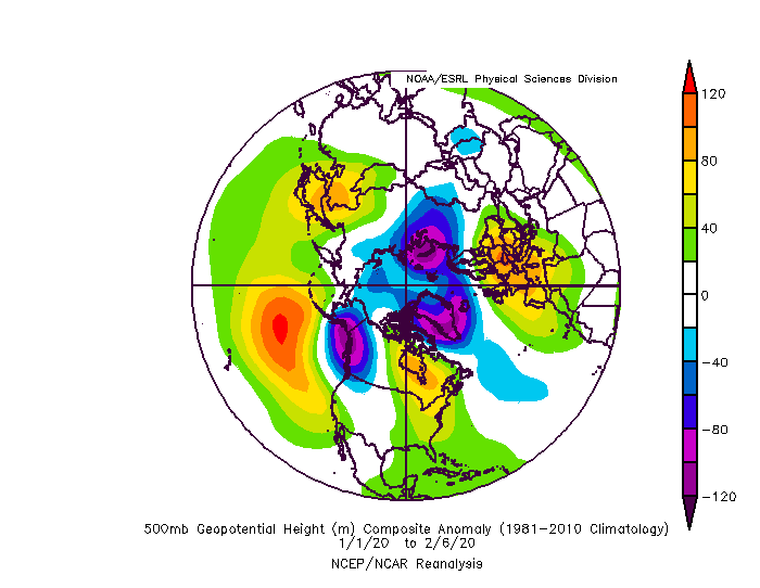
We’ve had variations yes. But all have featured 2 constants. +NAM and ridging centered unfavorably in the PAC leading to a -pna. The pac pattern has gone through fluctuations but the mean ridge has continued to be too far west. Furthermore those 2 aren’t totally a bad luck combo. That pac pattern is unfavorable for high latitude disruption. One is feeding into the other. You aren’t going to get a +5 stdv ridge all the time for months but the pac forcing has plain sucked straight through.
-
History said if we didn’t see a major flip in the NAM by late January that with the pac pattern this year we were toast. Simply put that pac pattern is stable. It tends to last. It can be offset by favorable blocking but when the AO remains hostile going into February it usually remains so until March if not the whole season. When we got to the last week of January and no improvement was hinted at I kind of realized we were very very very likely looking at a total dud. A fluke can happen. March is the best bet. But this has had all the tells of a dumpster fire season since late December.
-
I know how you feel...it’s why I did this. But I agree on NH. If I move someday that’s where we have in mind. In other news got some face shots on the last run. Found a stash in the Moran Face woods of the new Teton lift that was still untouched.
-
Made it into JH last night around 12:30. Drive from Idaho falls was longer because Teton pass was closed for avalanche control. Done a few runs through Saratoga bowl. Chest deep. They’ve had about 40” so far the last 3 days and it’s absolutely dumping right now. 2”/hr easy. It’s supposed to end late tonight then be sunny the next few days.
-
Luckily everything was on time and made it.
-
I don't know if its "lag effect" or if the actual effect that causes the propensity for a -NAO is the increasing solar radiation while in a still relatively low background state. I know in the last few months I have done a little more digging into the statistics and the propensity for more -NAO AFTER the solar minimum is obvious. Furthermore...some of the "correlations" I've seen people post regarding certain factors while in "low solar" state when you examine the years seem to be skewed by the extreme -NAO from the members of the data set that occurred AFTER the solar minimum but still in a low solar background state. There doesn't seem to be as much effect in low solar before the minimum. You have to be careful when using data sets that only include a limited number of years that one subset within the larger set isn't skewing the results. Either way we SHOULD get some -NAO years coming up. If we go another 3 years after a solar minimum with no blocking THEN I would start to join the "why can't we get blocking anymore" group. ETA: Had I done some of the data analysis I did a few weeks ago wrt the solar cycle and QBO...I probably would not have been as bullish (wrong) about this winter. Live and learn. I will not make that mistake again.
-
@Bob Chill Jackson Hole was definitely the right choice. 25" so far...looks like its absolutely dumping on cam right now...4-8" more expected today...with a lull tonight that I hope to use to get into town...then one last wave with 3-6" more expected tomorrow. Most importantly the temperatures stay cold enough to preserve the powder....highs staying below freezing even at the base through Monday. Aspen did OK like you said they would...about 8" so far with maybe another 3-6 BUT they will be in the mid to upper 40's over the weekend and so the lower half is likely to get pretty crusty... Like you said the northern mountains in CO did much better but frankly I have skied the crap out of most of them and wasn't really interested in another trip there.
-
I don't know. We just had a 2 year la nina cycle from 2017-2018. It wasn't a strong event but it was a 2 year cold event that peaked moderate for a time in 2018. I think this is bigger than enso...look at the SST for the entire pacific...hell the entire globe for that matter....its warm almost everywhere. You are starting to punch above my pay grade though with speculating what the effects of a la nina would be on the overall profile...could it "reset" the walker cell circulation yea...or it could just give us a crappy nina winter then resume what we are in right now. What we might have to accept is this is just the new normal...honestly this isnt a new thing its just we had a nice run and now we are stuck in the middle of this crap but we forget how 1997-2002 was mostly crap except for one epic week in 2000. 2007-2009 was mostly crap. 2011-2013 was mostly crap. We have always had these cycles. However the "crap" periods are getting warmer and warmer with less fluke minor snowfalls within those periods. One thing that I think is getting overplayed is the idea that we can't get a -NAO anymore. The NAO runs in cycles. We have had periods with very little blocking before. But we actually had a GREAT period of blocking for about 6 weeks in 2016. We got the HECS and a couple minor snowfalls out of it. We had an epic blocking period from very late Feb through March in 2018. Had that started maybe 2 weeks earlier we probably get a 1958 type repeat out of that. We did get one really good snowfall in March and just barely missed a couple others. Last year we did get some blocking. It just wasn't the epic historic block to end all blocks that the long range guidance kept teasing. But we got enough of a block (bootleg or not) that it suppressed that December storm. We had enough blocking to get DC that 10" storm in January. And February had just enough blocking up top that I got a couple nice snowstorms here even with a completely awful Pacific pattern. Yea the NAO has been crazy positive this year...and overall positive most of the time the last several years...but its not like nao blocking has gone extinct for 10 years or something. People are over-reacting. Especially since there is usually a run of +NAO years leading up to the solar minimum and this minimum keeps getting pushed further out...once we reach minimum we should see a reversal to more -NAO in the years that follow. My best guess is that our new normal is to have even worse bad runs...years where we spend most of year in shutout no hope patterns...but then runs of epicness where the warmer profile means juiced up storms in cold periods...less odds of wasted cold. So the highs will be higher but the lows will be lower. That is probably our new normal.
-
If 90% of the oceans (especially the pac) are going to be a hot tub we absolutely need the high latitudes to cooperate. It’s been this way for a while now. The only time we get a sustained workable pattern is when we get either a massive east based EPO ridge or a -NAO. Everything else equals a warm pattern.
-
@mappy just saw what happened...so sorry I hope she is ok
-
I am going to be REALLY REALLY pissed off if my flight tomorrow at 5pm out of BWI gets delayed or cancelled because of wind. Even a delay would be catastrophic since my connector flight only has 35 mins in between.
-
It's really hard to get a "good angle" with the kind of +NAO we are dealing with. What we are really talking about with the "angle" is getting a front running region of WAA precip to the east of the low...instead of the more typical band that you get associated with the strong southerly flow just ahead and north of the low. With a storm taking a NW track that stuff will never do us any good. But to get that projection east of the precip you need to have resistance in the flow. Both cold air resistance to enhance lift...and resistance to ridging in the longwave flow to turn the mid level winds more east and direct them into the cold before it erodes. We don't have any of that resistance, with a raging +NAO. Getting a really nice thump from a NW track storm is a LOT more common and likely when we have some blocking. Getting that in this pattern... yea have fun tracking that again. Our better bet is getting the cold to penetrate further south like the GFS and then praying one of the waves can amplify just enough. But its a rock and a hard place...no amplification and the wave is flat and weak. Amplify and it likely cuts. We need a perfect lucky thread the needle solution.
-
Sometimes the strat stuff is overblown because the spv isn’t always coupled well with the tpv. And if the pv isn’t that strong then bottom up wave disruption can be good enough. But this year the spv and tpv have been as couples as I’ve ever seen and both are record strong, so it does matter.
-
Seems your enjoyment is mostly complaining about how everyone else analyzes weather. No one is stopping you from talking about it however you want. So instead of repeatedly whining about how everyone else does things why don’t you simply lead by example...discuss the long range however you want. No one is stopping you. But 90% of your posts in here are just complaints 2. If you only want to discuss things inside 3 days you are in the wrong thread.


