psuhoffman
-
Posts
27,419 -
Joined
-
Last visited
Content Type
Profiles
Blogs
Forums
American Weather
Media Demo
Store
Gallery
Everything posted by psuhoffman
-

December 16-17, 2020 Winter Storm Obs/Nowcasting
psuhoffman replied to WxUSAF's topic in Mid Atlantic
@mappy -
December 16-17, 2020 Winter Storm Obs/Nowcasting
psuhoffman replied to WxUSAF's topic in Mid Atlantic
warm layer at 750 mb -
December 16-17, 2020 Winter Storm Obs/Nowcasting
psuhoffman replied to WxUSAF's topic in Mid Atlantic
Yes...track might have been slightly better but it continued the trend of tightening up the mid levels so there is a much tighter thermal gradient NW of the low track. Verbatim you go to sleet for about an hour in the afternoon...then back to snow for several more hours before you lose the thermals right as the best precip is moving out anyways...you might get a little light snow on the back end but that looks mostly northeats of you. But this is a pretty good run...80% of the qpf is probably snow. The warm layer never makes it further west then that ridge you can probably see from your house just west of leesburg. Adjust 10 miles east and you stay all snow. Actually...if you take the euro and adjust it to this track we would both get a pretty darn good outcome. Even closer to the cities would do well. That is probably what we need here...slight eastward track adjustment and this new idea of a better closed circulation to be correct. -
December 16-17, 2020 Winter Storm Obs/Nowcasting
psuhoffman replied to WxUSAF's topic in Mid Atlantic
It is...we got the trend we need for a late save...no more further westward adjustment to the track...and a continuation of the better mid level close/pass to promote a tightly wound system by cutting off the easterlies sooner. A more tightly wound synced up "phased" system at all levels will cut off the easterlies to the west of the low center and prevent that warm layer from blasting as far inland... But like i said we need the west trend of the track to stop for that to matter...if we can keep the track east of us AND get that trend to continue we could save a decent outcome here. Maybe no Ji level win but something most of us would take right now. -
December 16-17, 2020 Winter Storm Obs/Nowcasting
psuhoffman replied to WxUSAF's topic in Mid Atlantic
Well...I think the inside track is becoming pretty locked in. But there have been some developments with a better H85 and H7 pass that are causing a more tightly wound thermal gradient with this storm and could also make the possibility of some banding as the low departs real. If we were to get the west trend of the low to stop and perhaps adjust just a slight bit back east...but keep those factors...some places could still do well. It's possible. But one warning...the west trend of the low track continued with 12z guidance. And the mitigating factors I listed above are maxed out. For example..on the euro there is a time about 3z when the low is literally on the east side of Baltimore and yet its snowing here. A couple hours later that snow rotates through the north side of Baltimore with the low over NE MD. But if that track adjusts any further west...well nothing else is going to matter...you aren't going to get snow if you are UNDER the low or east of it. So we need both the better mid level depiction of the 12z guidance...but also we absolutely NEED the west trend of the low track to stop NOW. Get a slight east bump in final track, which is very possible...trends don't always continue right to the end...at some point guidance could pick up on reality...and maybe even over amplify some. Get that east adjustment by 50 miles and keep the better mid level look and maybe places closer to the city still reach warning criteria. Southeast of DC yes...this just isnt the right setup and I don't see anything that saves them. For 95...its getting tough but there is still an outside chance if those things I said above break right...namely we get a slight east adjustment to the track AND the better mid levels. For people NW of the fall line...very much still in the game for a decent event so long as expectations have be reset. Those crazy numbers we were throwing around 48 hours ago are gone. The track is just too far west for that...but we could still pull out a decent event if things break our way. But like I said above...its troubling that we continue to see a west shift every run on the guidance and we are completely out of any breathing room now. IF there is any further west adjustment then its a fail for everyone east of the blue ridge and south of PA. -
Surface track was west...mid level results were better due to a better close off of the mid and upper level circulations earlier. That would lead to a tighter wound system...which is good if you have an inside track. There was a lot to like in the 12z GFS I was just pointing out that the larger trend of the track shifting west did not halt, that was the bad.
-
This is what I saw
-
Death by a thousand paper cuts. The high has trended SLIGHTLY NE of where it was days ago. The confluence in the NE weakened some. The 50/50 moves out slightly faster...and the storm slowed down 6-12 hours...increasing the spacing between the two and allowing for more ridging in front of it. I was always bothered by how far west the upper level trough was going neutral and starting to lift, we needed all those other things to offset and they went the wrong way. Some problems that I think the globals had a hard time seeing at range...that are now coming into focus (NAM saw it from jump) was the without a closed off mid and upper level circulation (ERS talked about this) there is nothing to stop the easterly flow north of the low from blasting way NW. Add in all the warm water and that is shifting the boundary west...and the low track right with it. I don't think there is any one thing to point to that did this...it was a lot of things that all went the wrong way...and that was partly why this was a slow bleed and not a sudden shift. No one factor suddenly got a LOT worse...they all just degraded along the margins a little. IMO what hurt us most was just a little too much spacing between the 50/50 combined with the trough digging in a little too far west then lifting instead of amplifying along the east coast. The other factors like warm water and less confluence and shallow cold could have overcome that if they had all trended perfectly...but the warts in the overall synoptic setup required a lot else to go perfect...for a time it seemed like they all would.
-
I don't agree. There are meso scale features to any run that might change the exact snow/ice output on some snowmap for a specific location. But the trend killing us is the NW shift in the low track. It's been relentless for 48 hours...it started as a very slow bleed that was hardly noticeable run to run but it where there...and its accelerated the last 3 runs. The 12z guidance shifted west again...across EVERYTHING i saw. Some of the runs had a better snow result for a specific spot due to a meso scale feature within the run...but across the board the track was a bad move. And that is way more important because those meso details will change every run and be a nowcast thing...but if that track keeps adjusting west it won't matter. Every shift west reduces the chances of all those meso features to help much. I think we have reached the stage where a lot of people are grasping at straws and holding on tight to whatever little speck of data they can find to give hope. I get it. I really do. But I just can't do the blinders bad analysis thing.
-
I don't know if I really view the GFS as a reversal of the trend. It shifted the low track NW. That is the trend...all our other problems come from the fact the low keeps trending west with every run. Within that the GFS improved on some meso features that helped us out. An earlier close of the mid level circulation and such a more tightly wound system. And that worked for us wrt snowfall. But that is a meso detail within the larger scale...and on the larger scale the trend was another shift west in the low track. It is fine to celebrate the good things about this GFS run but we shouldn't overlook the bad. If the trend in the track were to halt NOW and adjust east slightly we are still close enough (NW of 95) to salvage things if the details like early close of the mid levels and banding and fast WAA thump go our way. So its good to see some of that on the GFS. But we need the larger trend with the track of the system to stop or it wont make any difference. If this tracks up west of the bay no one in here is going to be happy no matter how the meso nowcast details shake out.
-
The dry slot is now a problem here because the track has shifted NW. It didn’t get dryer it just shifted the heavy qpf up into PA! That dryslot is because the best WAA and fgen have shifted northwest by then because the track shifted NW. It wouldn’t be snowing where that dryslot is anyways because there is a huge mid level warm layer and that’s why the dryslot. To simplify the WAA lift stopped because the cold has been scoured out and is no longer resisting and forcing the warmth to lift over it. Again there will be 20”+ totals with this storm. It’s plenty wet. Those totals just won’t be anywhere near us as the track keeps shifting north.
-
@mappy 6z euro was good if you take it in a vacuum but it again nudged everything NW as every run has for 2 days and even up here we are out of any wiggle room. Any further adjustment and we will lose both the WAA front thump but especially any back end as the best forcing for that keeps shifting north. If the trend stops right now we are ok but any continued west shifts of the track today and we are in trouble even up here.
-
I don’t want to be overly critical but over the years it seems they are often a little slow to adjust to changing guidance. This works both ways.
-
The QPF is lower because it tracks the storm up over CAPEs house and into southern NJ. That pushes the best forcing further NW towards state college PA. That’s the perfect track for them to get crushed but it’s getting inside where we can expect to get big totals.
-
@Ji trends. It was significantly worse then 18z. The bleeding hasn’t stopped. I’d like to see a suite of guidance where we’re not must grasping at things like “well that wasn’t as much worse as I feared”.
-
?
-
Gem products shifted west and warmer this cycle. That’s all I’m taking away.
-
Yea but those precip plots are “previous 6 hours” and the temps are at the end of the period as temps crash on the back. Need to see the temps at 48hrs to know if it’s better or your seeing it AFTER the warm surge. Would imply at least some snow on the back but how much hard to say without that info.
-
It knows
-
12knam isn’t a big event even up here imo. 2-3 before and 1-3 after a flip imo. 3k would be fun though. Good 4-6” front thump then 4-8” back. Go with the 3k.
-
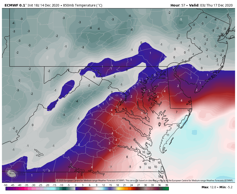
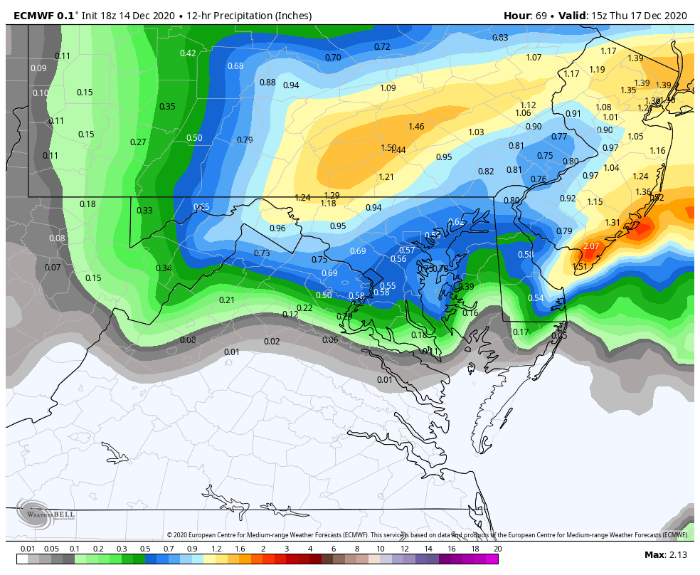
This is where our area starts to lose the thermals on the WAA side of the storm. It's a step back on this part. The red line is the 850 but like you said at this point the layer is isothermal from 850 down so its pretty much the rain snow line there...you can see what qpf came before the transition...you can estimate how the area did...northern zones hold on 1-2 hours longer...south of DC gets very little snow before going to rain. 1z here is about the worst look for the thermals. This is the NW extent of both the surface and mid level warmth. I have estimated the rain and sleet lines here by tracing the 925 and 850 0 lines. 2 hours later by 3z the temps are crashing and I would estimate everyone NW of 95 is going back to snow or has already. There are some pockets in the zone of subsidence NW of the developing banding of warmth but if they are between heavy bands at the time your not missing out on much accumulation anyways...point is I think we can assume from 3z on anything that falls is snowfall from 95 NW SO this last plot is the qpf that falls after that...and this is where the bulk of the snow comes from. This looks great...I would sign up for it...but I do NOT like living on the deform love as 90% of the storm. That can disapear real quick if things don't come together right. But the euro has been remarkably consistent with that in our area so maybe... so there is good and bad here...but again I am nervous relying almost entirely on the back side. Even up here its only about 3-4" before a flip to sleet...the other 14" if gives me is from the deform. If that happens GREAT but my rule is usually to treat that as bonus. Anyways... hope that helped.

-
@high risk The NAM does sometimes sniff stuff out. It nailed the sleet fest coming from range in March 2017 when all the globals had snow. But the problem is, its wildly inconsistent at range...which is to be expected for a model designed to handle convection and meso scale banding. It is useful in showing thermals better and a better detailed representation of what the storm might look like...but wrt synoptic level general things like track, at range it's hard to take any one run seriously because you don't know what it is onto something or when it is just on something. @BTRWx's Thanks Giving You NEED to stop with those crap snow depth maps. I have no idea how they are calculated but over the years they have been just as garbage as the weenie weatherbell ones. They end up seeming right for the same reason some of the trolls here do...because we fails so often. The models are often wrong and thigns shift worse. And when that happens...it makes a map like those look good. But whenever a storm actually does what the guidance says...those bust low. WAY LOW. I will give you one example just because I looked at the soundings. The NAM one you posted shows Westminster with 3" of positive snow depth. But they get about an inch of QPF with all levels at or below freezing. They get another .8 of QPF that is obviously sleet from the sounding. The surface is below freezing the whole time. Heck even if the whole storm was sleet that would be more than 3"!!! That is just crazy stupid. Now maybe the storm shifts even further NW and then 3" in Westminster isn't a bad idea. If the track actually penetrates inside the mouth of the Potomac...that would be trouble for up here...but a track like that NAM had over the southern Bay in up the eastern Delmarva supports a big snow (with some mixing yes) up here...and the model shows that if you look at the actual soundings and hour by hour plots...then that depth map shows something completely different. THis is not the only time but its a current example of how that map is just WRONG.
-
I think their being harsh but I noticed your not really predicting anything much different then most but it’s the tone. Instead of focusing on a he positives for the parts of the region that get snow you are focused more on the fail aspects. I get crap for that too sometimes. No one likes to hear depressing news. Even if they know it’s true.
-
Thanks. That valley is probably about your elevation. ~800’. They are still out having a blast. Made 3 snowmen so far and a huge snowfall fight with the neighbors kids and now working on a snow fort. They have been asking everyday when it’s going to snow ever since it started getting colder.
-
Roads are fine. My driveway did cover during the last very heavy burst where rates were like 2”/hr for a time but melted immediately after. And I’m close to the highest spot in the county.