psuhoffman
-
Posts
27,456 -
Joined
-
Last visited
Content Type
Profiles
Blogs
Forums
American Weather
Media Demo
Store
Gallery
Everything posted by psuhoffman
-
If I were where you are...I would feel the same way.
-
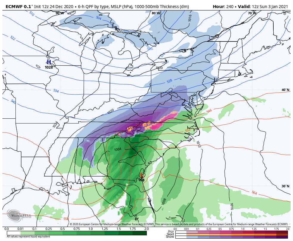
@Ji the difference with this euro run v 0z was the block anchored more in our classic spot v over NF allowing the trough axis to progress further east before stalling and doing the same fujiwara deal. But for that range they have a similar idea wrt progression.
-
Either get that NS SW out of the way, or behind it...really anywhere else but right on top and it’s a BIG storm.
-
@Ji the setup is nice but verbatim I don’t think that would turn the corner. The trough split and the northern SW is pressing down on the STJ one. Its a nice little event but I doubt it became a monster in the next frame. My interpretation isn’t 100% though, there is enough room that MAYBE...but it looked to slide east not turn the corner. But now we’re analyzing details when the whole synoptic setup will go through significant edits. I’ll say this about today’s runs. They all get a perfect SW track going after the New Years cutter. The cmc is poised for something around day 11-12. Euro has it. Gfs has 2 perfect SW passes but the problem on the GFS is just no cold at all. None. Zip. That’s a threat. Won’t lie we’ve wasted blocks because of no cold early in the season before. Later in winter blocks work more and more to produce enough domestic cold. We will see.
-
For the people
-
‘‘Twas the night before Christmas and all across the net, Ji was trolling cause the latest GFS was nothing but wet. Meanwhile the snow weenies readied for bed, hoping soon their winter dreams would be fed. Pictures of h5 plots with lots of high latitude red, played all night like a fantasy in their head. They told Ji to relax as he went full tilt to the max. That even though the operational was wetter, don’t worry the ensembles will look better. But Stormtracker knew our climo wasn’t a good bet, so he thought it over and decided to jet. But he’ll be back soon and we’ll all be together, to celebrate the blocking and our snowy January weather. The strat warm is coming and it will do the trick, by mid January flakes will be falling and things should get epic. So I say to you my friends as we wait for the pattern to get right, Merry Christmas to all and to all a goodnight.
-
-
As is that’s likely to cut due north. Actually because of too much blocking. The blocking retrograded so far southwest that the trough cannot progress east at all and is just doing a fujiwara with SWs rotating around. But it has potential in that if you adjust the block north slightly it’s better. I Don’t mind seeing a too extreme solution.
-
Everything lol
-
Can’t argue. It’s pretty rough.
-
Look at the 850 anomalies. The air is cold enough if we get a decent storm track. But regarding the surface anomalies there are 2 factors. First they use 1981-2010 climo to calculate and frankly our base state is warmer. Slightly below normal for RIGHT NOW is probably slightly above normal for the climo period the model is using. That’s depressing but it is what it is. The bigger factor is that we’re still suffering from the worst fall pattern ever that didn’t allow any cold to build anywhere in North America. Then blocking set in but we never got cross polar flow to inject the cold over in Asia. So we essentially blocked in the pac puke. The domestic airmass is slowly cooling but we’re still paying the price for the fact we rolled into December with the whole continent torching. There just isn’t any true cold around. Very small pockets form when an intense cyclone mixes it down then it quickly mixes with the surrounding airmass and moderates. We just need to hope that airmass is “cold enough” that with a good track we can get snow. It should be as we get into January. And if we can get an injection from cross polar flow at some point it would help going forward.
-
I am by no means an NWP expert. I didn’t get that deep into that before switching majors and most of what I do know is actually from my own research out of curiosity and wanting to understand some. But from my limited grasp if it is an EDM as he says then it focuses on using time series data to make causal inferences about the factors governing the observations in the time series and then use those correlations and inferred causalities to predict the future. That’s different from the typical nonlinear hydrostatic and non hydrostatic models that initialize the atmosphere then use the differential equations that govern physics to predict the future. Back to the original issue EDMs require significantly less computing power and resources. I am sure I didn’t do this justice and hopefully one of our resident NWP experts can chime in with a better explanation. @Disc @dtk @high risk
-
Been a nice week up here...barely lost any snow all week. Some shots from Friday and today From my walk Friday my jebwalk with my 2 year old this evening (at her insistence)
- 616 replies
-
- 10
-

-

-
The first storm after Xmas (the only one in range of worrying about yet) doesn’t cut. It gets shredded them redevelops as a miller b that misses us. Problem is the NS wave runs out ahead of the SS and gets shredded but it also flattens the heights and squashes the SS until it phases and comes together too late. We need the SS out in front so the NS can phase in to our south. Look at the h5 for most of our big snows (it’s on the climo thread) there is a trough near AK usually.
-
There used to be a great discussion archived by Gary Gray on all the models each day that week. The Euro was closest to reality but it’s kind of a myth that it nailed it. From his discussion it seemed the euro most of the week was further north and did get more snow then the American guidance into our area but it was by no means close to reality. I think NWS was splitting the difference with a 3-6” forecast between the American guidance that had barely anything in DC and the euro that showed like 6-10”. It did but it also trended weaker and strung out. A lobe of the tpv rotated on top of it and squashed the system. From 72 hours it looked like a 20” snowstorm in PA and it ended up a 4-8” snow in VA. It wasn’t really last minute though. The shift happened around 48 hours. I was up in PA that year and by the last 36 hours knew we were screwed.
-
Happy Anniversary @mappy
-
How do you hyperlink pictures? I used to use imgur but it stopped working.
-
@ErinInTheSky @MillvilleWx @Winter Wizard There is a lot of perception bias to this. But I do think globals underestimate mid level warm intrusions and that’s a BIG deal here. That factor alone probably does make us more prone to negative then positive busts. But those do happen also. Only they aren’t usually going to be going from 3” to 12+ at the last second. That’s kinda extreme. DC area doesn’t even get that many of those storms. And most of our negative rug pull busts aren’t that close to game time we just remember them that way. Even this storm the writing was on the wall 48 hours out that big totals were slipping away. We knew. The 1996 storm we didn’t know until 24 hours from first flakes it was going to be that big. It started snowing late evening Saturday and Friday the forecast was 3-6”. Then the 0z guidance shifted way north and Bob Ryan interrupted the 11pm news to say it was gonna be BIG and the rest is history. We knew this storm was going wrong before we knew that was going right! @HighStakes there was another storm in Feb 1996 that was a total shock. A miller B that was supposed to develop too late for our area. Night before the forecast was nothing and woke up in Herndon VA to 3” and heavy snow. Ended up with 8” and some places got 12”. There are some others you can add to the list below. More recently the Feb 2006 storm wasn’t really locked in until 48 hours out. There were hints on some runs (famously the JMA) but it was 48 hours that the majority of guidance caught on. And even this it outperformed the final forecasts. Did someone mention the Jan 30 2010 storm? The second Feb 2010 Storm wasn’t on guidance until 48 hours out. A lot of the 2014 storms didn’t appear until 72 hours and didn’t look big until 36-48 hours out. The early march storm looked north until about 48 hours out. Feb 2015 some places in MD for 12” when the forecast was 3-6 when the storm started. Jan 2019 was a pretty big +bust in your area One thing I’ve noticed I can’t remember any last minute big busts from a storm suddenly shifting way south. That just isn’t likely. It’s not as bad as it used to be but there is still a tendency for big storms to trend north some the final 48 hours. Add in their underestimate of warm layers and that combo makes up most of our last second busts.
-
Their lift served vert is about 5600 I think...but its about 6000 if you start from the hike to terrain at the sub peak. I especially like the north bowl drop into the alpine off piste terrain on the back side though. Only about 3000 vert to that I think but its the best terrain. The front side is mostly really long cruisers that are good to bomb down at the end of the day. When were you skiing at Squaw? I've not been there...but most resorts out west have an open policy with natural terrain now. I know that was not so when I first started getting into skiing in the 90s...but has changed since. Not sure how "liberal" you want it to be though...they do typically have "access gates" to the "out of bounds" terrain with warnings and disclaimers. Jackson asks that you use a transponder if venturing into the avalanche terrain...but I don't think they will do anything if you dont...you just might not make it if something goes wrong. I have skiied extensively "out of bounds" at Utah, Jackson Hole, Revelstoke and Aspen/Snowmass and never had an issue. The other new thing is opening up natural terrain "in bounds". Vail opened blue sky which is a whole mountain of mostly natural terrain to play with. Revelstoke's whole north side has huge areas of natural terrain in bounds. You don't really have to go out of bounds to get the out of bounds experience anymore. I want to ski Europe someday...just has never worked out.
-
Sounds a little like Revelstoke. They have about 6000 ft of vertical. Bombing down that really burns by the last 1000 feet.
-
The problem is we probably care way more then whoever made the decision. I was lucky. Didn’t learn until I was 18 and everyone said how hard it would be and it took me about 3 runs to just figure it out. But I think it helped that I was in shape (then) from playing soccer at PSU plus I had played street hockey on roller blades growing up in NJ. A lot of the balance is somewhat similar. Just took a few runs to figure out the details. Now golf....I feel like someone invented that sport as a bad joke.
-
You probably aren’t balancing your weight properly or transferring weight between skis on turns. Without proper weight distribution the mechanics become difficult. Your weight should be centered on the balls of your feet when aimed downhill. Most beginners lean back as a defensive reflex and end up riding the tails and that’s bad because most of your control comes from the front of the ski. As you turn always distribute your weight to the downhill ski. When I’m teaching people I often lift one ski up and ski entirely on one ski at a time to make the point. Once you master the weight distribution the rest comes easier. To stop you execute a turn only sharper. But right as you would begin to turn uphill instead you lean into the slope and dig your edge into the snow. The first few times you will likely spin out a bit. That’s ok. At some point the “feel” just clicks and you’re good to go.
-
I can't wait to do some hiking (and more skiing) up there when my son and daughter get a little older.
-
Roads are fine. My driveway did cover during the last very heavy burst where rates were like 2”/hr for a time but melted immediately after. And I’m close to the highest spot in the county.