

psuhoffman
-
Posts
27,419 -
Joined
-
Last visited
Content Type
Profiles
Blogs
Forums
American Weather
Media Demo
Store
Gallery
Everything posted by psuhoffman
-
We need that vortex to back off some. Ideally if it backs off into the WPO it redirects that Nina ridge into the pna domain and western Canada. Absent that it’s even better if it just goes away. That’s not perfect but if...big if..we have a -AO/NAO we have overcome that pac ridge before. But we’ve never overcome both a pac ridge AND AK vortex. That’s just too much for any other factor to fix.
-
Where do you get the para for non 0z runs?
-
Funny you say that...teaching is my actual profession...just not weather. I teach Constitutional Law, Economics, and Government. If I ever did go back and finish my Meteorology degree my dream job would be teaching a meteorology course. I wouldn’t mind working on a pacific patterns discussion. What exactly are you looking for? What works wrt snow chances? One issue is I’m not sure what historical analogs still work. I’ve noticed a few times recently a look that in the 50s-90s produced a colder snowy outcome not work wrt temps in recent years. If you narrow the examples to only recent years you get more relevant examples but you get too small a set of snowstorms to draw much significance wrt how likely a pattern is to replicate that result.
-
I mean we pretty much know the next 2 weeks is probably lost. Maybe we get lucky but...the gfs does get the pac right by day 14 and the high latitudes are still very workable.
-
He is but he didn’t come in here and make shit posts and pick fights. Whatever issues he had are not the same ones you are having. You’re intentionally being antagonistic then making a “why is everyone picking on me” defense. That’s lame.
-
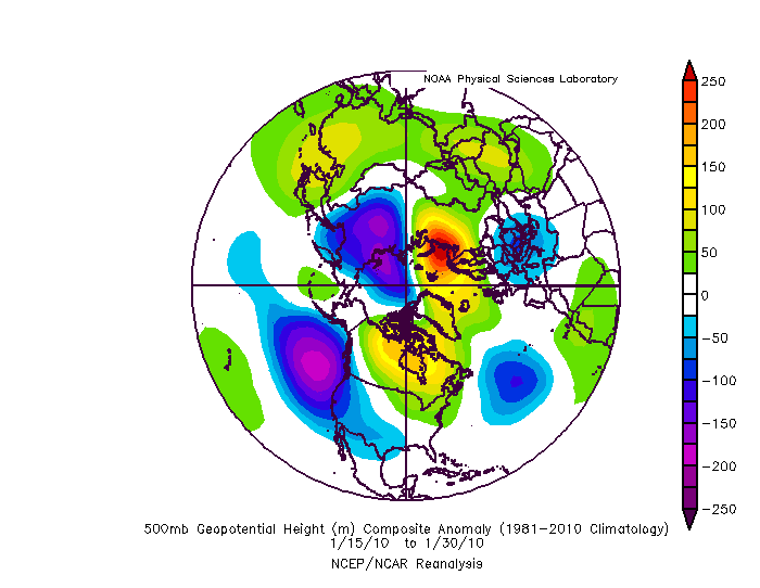
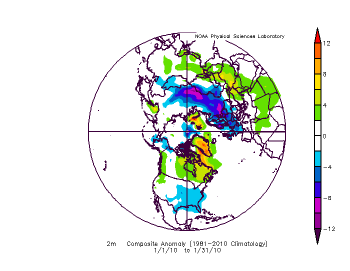
Our current predicament bears some similarities to the dead period in Jan 2010. That evolved into a barely cold enough look in Feb but it took a perfect west NAO Rex block. The pac was still garbage with a mean trough along the west coast. But has the base state warmed such that it wouldn’t work anymore. That’s a fair question.
-
-
Even money it’s not a noob. The style seems familiar. Then again there is no shortage of said “style” in our society right now.
-
2010 is probably the goal here. We had pac help in Dec but the second round that year was all high latitude driven overcoming a crap pac. But it was PERFECT blocking so that’s living on the edge. But also...it was 11 years ago. We are warming. And a lot of those storms were borderline. Only the late Jan one was cold. All the others after if you add a few degrees we are in trouble. And the temps in Canada that Jan were warm but not as warm as now! Probably helped that year the pac wasn’t puke early and allowed a cold pool to build. Then the Atlantic was able to prevent it from being completely obliterated later. Either way that temp profile in NW Canada is way better then now!
-
It’s just an example. Yukon, NW Territories, Nanavut...point is northern Canada has to work as a source region most of the time. An extended period of unimpeded cross polar flow to tap Siberia is too rare to rely on for our snow chances. Unless we want those chances to be like once every few years.
-
Some people do that every year. It’s a game. And you cherry picked the coldest part of the day on that temp plot. The 18z temps look pretty ugly. But again...we’re talking about how it’s sad if that pattern only produces above normal temps. That’s related but not the same as snow chances.
-
Good call
-
That’s exactly what Cape and I said like 30 mins ago. Again you’re taking things out of context.
-
Yea but this is missing an even bigger picture. Central Asia is always cold. It’s high latitude land locked. But how often are we realistically going to have that as our source region. It’s on the other side of the globe...literally!!! That’s rarely our source region. And honestly 50% of the time when it is that’s not a good snowstorm look. A huge arse full lat EPO ridge with a +NAO is a cold dry look and we typically warm when a wave approaches. We would either need that followed by a quick NAO flip or a perfectly positioned positively tilted epo ridge to get a progressive wave pattern. That’s going to be super rare. If the Yukon doesn’t work as a source region we’re going to be pretty fooked most of the time. That sounds way too much like the people in the southeast forum who need to pray the stars align while a rare white elk and a unicorn stroll by every 5 years to have a shot at significant snow!
-
Where is the cold going to come from. The arctic is on fire. that cold in Asia is locked with a ridge bridge. We would need a +NAO actually with an epo ridge to access that. ETA; but that would dump it too far west and then we would need the NAO to flip again and...just forget it. That’s a pipe dream. But we need the thermal profile to cool some over N America somehow.
-
Your using his post out of context
-
EPS doesn’t pull the pac trough back at all. Would be difficult. But the GEFS has been handling that feature better. It handled it better back in early Dec then recently the EPS had a better look and caved. If we want a tie breaker GEPS agrees with the GEFS wrt pulling back the vortex out of AK after a short visit. It has tended to want to be west of Ak “most of the time” so I will cautiously side with that idea. We will see. ETA: the GEPS is hilarious though in that it has a great PNA EPO ridge, -AO/NAO...and absolutely torches the whole continent. The coldest anomalies in North America are where you would expect in that pattern...the mid Atlantic, but it’s still +3-4 v +10everywhere else. It’s even more comical then the run I used as an example from the other day! Everything is perfect and all we can manage is slightly above normal temps. Kinda scary.
-
To be fair the pac has just begun to pull back there. That first trough won’t do it. There is too much ridging in front. That’s going to cut and timing differences plus some outliers will lead to that torch look. But if the h5 is correct it would be AFTER that period probably behind a cutter that we might see a colder regime. Not COLD...maybe cold enough. If you look at 384 there is cold at 850 beginning to show moving east. We don’t need much of a cold anomaly in mid January to work with a good track. At the surface it looks like a lot of “normal” by day 16. But given the base state and that an members that ridge will torch temps that normal might be slightly below if we take out warm outlier members. yes I’m painting an optimistic vision here but playing the devils advocate that MAYBE that look can work.
-
This is just data..people can draw their own inferences. Using the day 8/11 analogs we get 15 years. 5 evolved no where good. 8 evolved into decent patterns and some snow. 4 evolved into epic snowy periods. Just as an interesting side note all the years with a SSW in the set evolved into either decent or good patterns. Makes sense. The years the AO stayed - evolved to a decent look later. The years the AO flipped positive turned into dreg which isn’t shocking given this pac with a +AO is basically last year again.
-
We will see. I think given the stable pac jet we are unlikely to get much cross polar flow. Maybe the SSW shakes things up. But leaving that aside I am very curious to see what happens if we ever get the N pac trough to pull back with the blocking far enough west to get the trough into the east. History on that says it should work. That a direct flow from the Yukon even absent cold for them would be cold enough to snow. If it isn’t that’s a bad sign for the damage that’s been done to our snow climo. If we need an arctic air source to get snow anymore that eliminates about 50% of the warning events from my historical case study!
-
If the N pac trough crashes into the west it’s over for a while. But last time long range guidance did that and we freaked out it quickly pulled back and we ended up tracking a legit threat. If that pac trough backs off some things become workable quick. But yea so long as that trough is centered over AK were in trouble.
-
For arctic cold yes. Need epo ridging. Historically we could snow fine without that. The majority of the warning events in my case study happened with temps near 32. Some above 32. A lot mixed at some point. Most of our snow historically wasn’t cold smoke. I do wonder if more recently the pacific isn’t becoming more important if warming has rendered domestic non arctic origin cold in effective for snow chances. That’s just speculation at this point.
-
Ji isn’t chasing car toppers and 1” events. And I kind of get it. He likes the thrill of the chase. The model runs that show some big hit. He isn’t in it for a cold day with snow showers.
-
You are totally right that he ignored other factors and focuses all on his baby the strat. Nothing is one thing in weather. It's so many variables working together...and when things are wrong its always more then one thing. But this is interesting to me...in the sense I am always trying to learn and this is an area I can definitely understand better. The N Pac vortex is definitely our most direct "problem" but I think it might be symbiotic to an extent with what he is talking about. I saw some posts from strat "experts" who implied that the anomalously strong vortext in the WPO and EPO domains are part of the process in getting a January SSW. Additionally getting a strong heat flux from the tropics in conjunction and you have the perfect setup to transport that heat poleward. Unfortunately we are in the way of that transport. There is some "evidence" of this on the 6z GEFS. This is a 5 day mean. From about 24 hours to 144 hours the N PAC vortex actually pulls back enough that we COULD have had a better outcome. And we might sneak in a snow event somewhere in there if we get VERY lucky...but the ridge over the northeast really screws it up. But that ridge has its inception in the tropics...if you go back and look at where a LOT of that heat got added it originated in the tropical pacific and was drawn up by the PAC trough so its symbiotic. But that ridge prevents systems from amplifying into the 50/50 region where it could help to retrograde the Atlantic blocking into a favorable spot. Instead systems cut way too far west and get stuck...and actually help to prevent the blocking from retrograding west. Basically because of that ridge in the northeast the block alignment gets systems stuck WEST of the block instead of UNDER the block. That gets the trough stuck in the west and cannot progress east UNDER THE BLOCK...like we want. I don't know how much of that ridge is amplified by the heat flux coming from the pacific...but whatever amount it is...it ain't helping that's for sure. So you are 100% right this is way more complicated then just saying its all about the SSW...but there may be a component here. Looking ahead...after 144 the N PAC vortex shifts east and that is lights out for a little while. It's obvious that the combo of the central pac ridge under the N pac vortex is going to create that pac jet problem...and its likely going to last all winter. But that N PAC is a net positive IMO. At times it shifts into AK and thats no good...but at times it has been far enough west to give us a shot. Mid December was a great example. It's centered far enough west coming up this week but that NE ridge...we just covered that. When the N PAC trough pulls back again...if the Block has shifted west enough and we don't have that ridge in the NE it could work. Looking out to the end of the run... Similar setup to this week...but this time the blocking has migrated far enough west to set up better alingment to the "blocking" to get the flow to progress east UNDER the block v get stuck west of it. This is still not a truly cold pattern...I don't think that is in the cards this year. The pac is not right...but a direct flow from the YUKON in mid January better work...and I mean this...if a direct discharge of domestic air from the Yukon (even absent cross polar flow) is no longer good enough in dead mid winter...we are in big trouble snow climo wise...and I am not having THAT debate on this just stating a fact. The issue is...does the blocking retrograde...and that is the thing. If that blocking remains more of a WAR we will likely get similar results. All the guidance says it does retrograde. And the way it progresses kinda makes sense it would...the PAC trough crashing into the west actually helps...its gets the trough stuck so far west for a time that it allows the WAR to retrograde on its own even absent much wave breaking simply beause there isnt strong low pressure stuck north of the lakes preventing it. But it all comes down to that...if when the pac back off again the blocking is centered in the western NAO domain we will get a good pattern. If it is still a WAR we won't imo.
-
Full disclosure I am not an expert of the strat so everything I’m about to say relies on stuff I’ve read about it from others I trust. But this might be a case of a blind squirrel finding a nut. I did see some evidence that the precursor periods to a SSW tend to be mild in the CONUS. On a very basic level it makes some sense. The largest source of heat added is the tropical pac. If that heat is being transported poleward we are kinda in the way. That’s just speculation. I’ve not seen enough on the “why” of the correlation just that it’s there.


