

psuhoffman
-
Posts
27,419 -
Joined
-
Last visited
Content Type
Profiles
Blogs
Forums
American Weather
Media Demo
Store
Gallery
Everything posted by psuhoffman
-
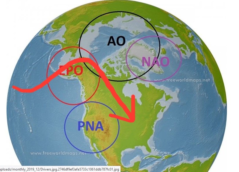
I think there is some confusion with what an EPO is. An extremely east based EPO coupled with a PNA ridge centered along the western US into western Canada is a great thing. But that’s not a typical EPO and I doubt that’s in the cards. A typical EPO ridge extending from the central PAC into AK is too far west and dumps the cold into the western US. Those both fall into “EPO” but for our purposes are totally different patterns. One good one bad...both under one index.
-
@CAPE everyone is mad at that north Pac trough but we’ve had some epic snowfall regimes with that look. 1996, 2003, 2010. And that trough is keeping the central pac ridge suppressed. That ridge (remember my soul crushing post last December)is the single biggest snow hope destroyer there is. It can even destroy a -NAO! We have occasionally overcome a pac ridge with a -NAO like feb 2006 but it was still a warm month and if they one storm hadn’t worked out we would have wasted a beautiful block because of that pac ridge. My number one “want” is keep that central pac ridge away. This look on the long range GEFS is getting dangerous. Retrograde that WPO vortex anymore and that pac ridge is going to go ape and we will be fighting a SE ridge even with a block! A perfect pac isn’t in the cards. Getting some huge stable PNA ridge just is unlikely with the current forcing. So imo a WPO vortex is by far the lesser of 2 evils v a central pac EPO ridge that dumps cold into the west while we ridge out! I don’t care about cold it it’s on the other side of the country!!!
-
Maybe. But sometimes with a -NAO a EPO ridge dumps the cold into the west unless it’s an east based EpO that extremes into Canada. If it’s a central pac EPO ridge into AK that’s actually a bad sign. It’s one of the few NAO killers.
-
Lol that’s super rare. Typically a ridge into AK and you get a trough dumped further west then that. Most of the time to get that wavelength spacing to work requires a -NAO also.
-
-
Yea I think we’re making slightly different points. I’m saying I hope that isn’t true because of an EPO is the best way to get snow in the new normal...the new normal is going to suck.
-
The EPO was positive in most yes and in the others it was neutral or only weakly negative. It wasn’t driving the bus. An epo ridge usually promotes a trough too far west for us. And a full latitude PNA/extremely east based EPO ridge absent a block is a cold dry look. Once in a while you can get a crazy storm like March 93 from that kind of ridiculous full hemisphere wave but I’ve shown in the past (when someone was throwing around that analog) how that was a huge anomaly and most of the time with a similar look we just get a short arctic blast then warm up. An exception would be what we had in 2014, an extremely positively tilted east EPO ridge that poked all the way into the AO domain. Then we can suppress the SE ridge and get progressive waves. 2015 worked because the TPV got displaced into Quebec. That works too. But those are really rare anomalies that I can’t find that many examples of historically. My point is the EPO alone doesn’t work. We need other factors. And yes an epo ridge with a -NAO can work...but actually a +EPO -NAO correlates to snow even more so obviously the EPO want the determinant. You’re point about 1-3” snows could be valid. I’ve not done much study on that. That’s not really my thing.
-
On the surface. But overall they aren’t as different as it seems. It’s a critical tipping point where there is enough space to amplify and get precip from that SW pass. GFS and Euro are barely on either side of that threshold. A minor shift in the mid and upper levels by either flips it’s surface solution.
-
Since 2015 I’ve had 9 warning level snowfalls. Not a single one was EPO driven (and we’ve had several beautiful epo ridges in that period). 7 were AO/NAO driven and 2 were PNA driven. Historically the numbers are similar. The EPO has never had much correlation to our snowfall. 2014-15 was an anomaly.
-
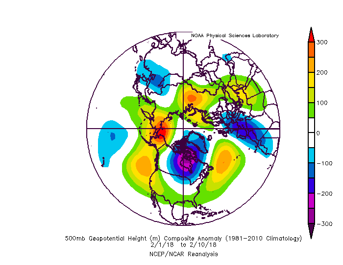
I don’t disagree but that’s not a trade I want to make. Im a snow fan not a cold fan. And a -epo will never be as effective at promoting a favorable storm track for snow. I think 2014 and 2015 gave a false impression of what a typical epo ridge pattern is. We’ve had quite a few great EPO ridge patterns since and none produced that result. This example from 2018 is way more indicative of a “normal” result in an epo ridge pattern. A lot of rain with a lot of snow to our northwest. I could pull out several more epo ridge patterns from the last 5 years that produced some cold into the US but no snow for us. ETA: you actually can do “better” in a EPO driven pattern then the typically more favored parts of our region, sometimes getting clipped by late developing progressive waves or follow up systems. So for the eastern shore maybe it’s not as bad a trade lol.
-
@CAPE but technically the long range guidance is starting to “hint” at a workable temp profile. This is the end of the GEFS. This should support what we need.
-
It’s all symbiotic. The way you knock that down is to get storms into that area. The wave break from those amplifying storms helps retrograde the ridge into the NAO domain. What derailed the last attempt to set off that chain reaction was the boundary ended to so far NW that storms cut and got stuck up in Canada. Never making it into the regions we need to set off the positive feedback cycle.
-
I was comparing them to the projected looks in mid January. Looks close enough to me. GEFS and EPS extended What I was talking about was the fact people are saying even that look is no good and why it’s still warm on the long range guidance. Now if that look never comes this is moot. But that look is actually a great snow look historically. That’s all I’m saying. Your second point is interesting. The one biggest change is the enhanced pac jet. But that seems to be a new normal since it’s existed for quite a while now regardless of enso state. But perhaps that has made that look less supportive then it once was. And your point about outdated analogs is true. But that also kind of feeds my point which summed up is “we better hope that look still works because it’s responsible for A LOT of our best snowstorms and it’s not like we’re picking up new ways to snow to replace it in this warmer climate base state”.
-
I do think that is a huge part of this. Even more then simply base state warming. We are a month behind in generating cold in our source regions. Plus we flipped right from that horrid (really was maybe the worst November into early December EVER) to a high latitude ridging pattern that locked in that puke airmass meaning the cold on our side has to develop mostly on its own without an infusion from Asia. And while the pattern has been better since there have still been periodic episodes of pacific maritime intrusion to delay the process. So in a way we still have a N American thermal profile more indicative of late fall not going into January.
-
Yea that’s why I said this discussion is NOT about our our chances. That look is cold enough to snow. But it’s annoying when any ridge brings +15 anomalies and under ideal perfect conditions the best a cold airmass can muster is -5.
-
Yes but that’s a chicken or the egg argument. One of the reasons the storm track is so far north (even during periods with a half decent pattern) is the warmth. Storms will ride the zone of best baroclinicity along the thermal boundary between subtropical air and polar air. When that boundary is up in Canada we’re screwed no matter what the steering currents are.
-
I am with Webb on this. The look being thrown out there...west based NAO with a trough west of SW of AK is our best snow look. It’s the most common look that came up when I studied every warning event. Without a block the trough in the north Pac would be a death sentence. But historically a -NAO has been plenty able to offset that and essentially what we get is all that pac energy crashing into the CONUS and being forced under the blocking with just enough cold. It’s not a cold look. Most of our snowiest periods were barely cold enough to snow. Frankly everyone wishing for these pac patterns that lead to arctic outbreaks...that’s NOT our snow look. That’s a cold dry warm wet look absent blocking. 80% of our snow comes in “barely cold enough to snow” blocking patterns with domestic cold sources. Yes getting a big huge epo ridge and a -NAO would be great...and some guidance even suggests that’s possible, but that’s also super rare. When you have a ridge on the NAO side there is usually going to be a trough on the Pac side. That’s basic wave physics. Only in rare instances where the TPV has been completely obliterated (and this year might end up that) can you get a ridge across the whole northern Hemisphere high latitudes. If that’s what we need to snow now...well I’d like to believe that’s not true. We already need so many moving parts to go right. But there will always be this one other thing we could point to and say “well that isn’t perfect” but imo keeping it real that look SHOULD work. I’m not saying it won’t. I think models are underplaying the cold. And HM pointed out the cold usually lags the SSW by 20 days. He also showed a graphic that clearly shows the warmth surge into the eastern US around the time of the SSW supporting the hypothesis we talked about yesterday. We probably just have to be patient. But in the end if we get a west based block I’m not going to just dismiss its failure as “well the pac” because in the past the pac look we have now was just fine with a -NAO! As for your second point wrt #bootleg I agree. I touched on this last night. I do think there is some truth to that point in that the warmth is biasing the NWP towards higher heights. But there is ample evidence it’s not just that. When you look at individual runs of OPs and control runs there is legit ridging and even a Rex block at times. So why are we to believe the ensembles have the same height pattern but not the blocking? Furthermore, at that range those are some crazy anomalies to explain fully by warmth. Lastly the pattern around wouldn’t fit. If that was totally due to pac warmth you would see a wave 1 look with a full latitude trough in the pac and a full latitude ridge in eastern N America. We do see that for a time when the NAO is east based and more of a WAR. But once it retrogrades suddenly you see a trough migrate east under the blocking. You wouldn’t see that if it was bootleg with that pac. And like you said smoothing at that range will mute the lines. At a specific time members have the ridge centered over Hudson Bay, some Baffin, some Davis, some Greenland. Timing and location differences will smooth out details. I respect their hypothesis and the one piece of evidence to support that theory is the pathetic temp response to the blocking however that can be explained in other ways (the temp base state on our side of the globe is just horrid right now) and the preponderance of all other evidence doesn’t support that conclusion imo. ETA: what made 2014 and 2015 work were rare oddities. A huge full latitude positively tilted EPO PNA ridge in 2014 and a crazy displaced TPV in 2015. Those were super rare and not typical ways we snow. I don’t want to rely on that 1/20 year type pattern to get snow.
-
This post isn’t specific to our snow chances. So hopefully everyone won’t freak out. It can still get cold enough to snow. That temp profile would probably work. Barely. Let’s also assume (because it’s scary not too) that is skewed a bit warm by some outliers. But what’s scary is that is literally the perfect pattern for us to be cold. Look at our source region...straight off the North Pole. The coldest anomalies in the northern Hemisphere are over N America and it’s weak sauce. Mostly -2 to -4 stuff. That’s it. And even that is bottled up on the Canadien prairie without the depth needed to press and spread southeast. @cbmclean pointed out how Asia and Europe have been cold, but their cold source is different. Siberia is a huge land locked high latitude region that is perfect to build deep cold. It’s one thing to see cold there. But even when we get cross polar flow on guidance and the “cold” shifts to our side...it’s not really cold. I’ve been watching this for a while and I’d like to see some evidence we can still build true deep arctic airmasses over North America without that once in a blue moon direct shot from Russia. And even then it seems to moderate quickly once out of the Siberian cold seeding grounds.
-
I’m optimistic. We will see.
-
@WxUSAF tonight’s op gfs I think is more indicative of what the ensembles are “seeing” then the bootleg heights issue. From 300-340 there is a full Rex block centered near the southern tip of Baffin with a 50/50 trapped doing loops under it. If anything that should be too much blocking. And yet it rains to Montreal during that period. There is no cold. The flow is blocked. The systems shear out. However...that is the first major longwave trough after the block retrogrades. Imo, like you said, if the blocking persists I think each subsequent wave will likely have a bit more cold to work with. The euro weekly ensembles, however, never quite get to that critical tipping point where there is enough depth of cold to keep storms from either waiting and cutting or shearing out. I agree that’s unlikely. But the gfs shows that it’s a “real” block...and still warm.
-
Yes...and this is what he was talking about. Get a ridge into the EPO (AK region) and it sends cold continental air down east of the Rockies into the central and eastern US.
-
I dunno. I’m sure the mean is biased positive some by the warmth near Davis but those are some strong anomalies to get at those ranges from just that. You will never see the ridge signature past 10-12 days due to smoothing on ensembles but when I look at most individual runs and the controls there is legit ridging and even a Rex block at times. Plus with the pac trough where it is we wouldn’t see lower heights into the central and eventually the eastern US in the long range without legit blocking. There would just be a wave 1 signature with full latitude trough on the west coast and a full latitude ridge in the east. I think past day 10 the blocking signature looks real imo. Will it actually evolve that way and can it overcome the pac and a scorched N Amer thermal profile though...?
-
Agree
-
We had a nice AO block in Dec though but it was centered northwest of a true NAO block. I respect Tombo and others who are saying it’s just higher heights but I respectfully disagree with that take. First of all it’s impossible to see the ridge in the height lines past 12 days or so due to timing and location differences between members. One might have the block centered over Greenland. Another Baffin. Another Hudson Bay. The ridge meanders around. Those differences smooth it out. Then you add in the outlier members and seeing a ridge signature at that range is not happening. But at the same time those kinds of + anomalies would be unlikely without a ridge somewhere. If it was weak + heights maybe. But to get those kinds of positives at those ranges given the smoothing and outliers would be almost impossible without a ridge somewhere on most members. Also we wouldn’t get lower heights across the CONUS with that pac if there wasnt true blocking. Add in the fact that the control has a true block and when I look at most operationals and individual members they do have blocking the evidence suggests that’s not it. I respect their hypothesis but I don’t see evidence of that. I think the simplest answer is the best. The pac is less then ideal. We begin the period with all of N AM torched. Despite a really good h5 look it thinks we never recover in that regard. History says domestic cold should work in that look. But the eps weekly members obviously think it’s just not going to be cold enough to keep storms from cutting. I think it’s wrong. I’ve seen it run too warm at range. We’ll see
-
Yea but 82 was very snowy in the mid Atlantic which is more common with a west based NAO block. Sometimes that can favor further southwest then NYC.

