

psuhoffman
-
Posts
26,285 -
Joined
-
Last visited
Content Type
Profiles
Blogs
Forums
American Weather
Media Demo
Store
Gallery
Everything posted by psuhoffman
-
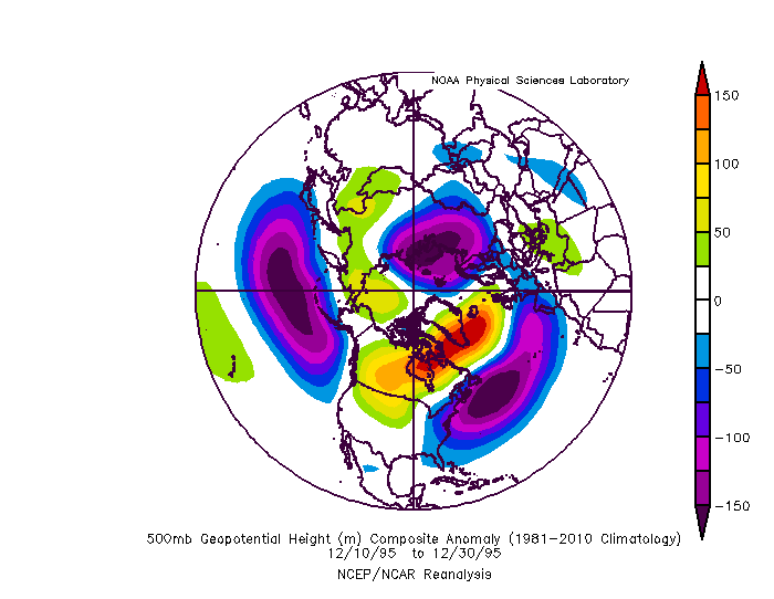
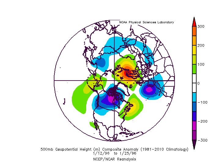
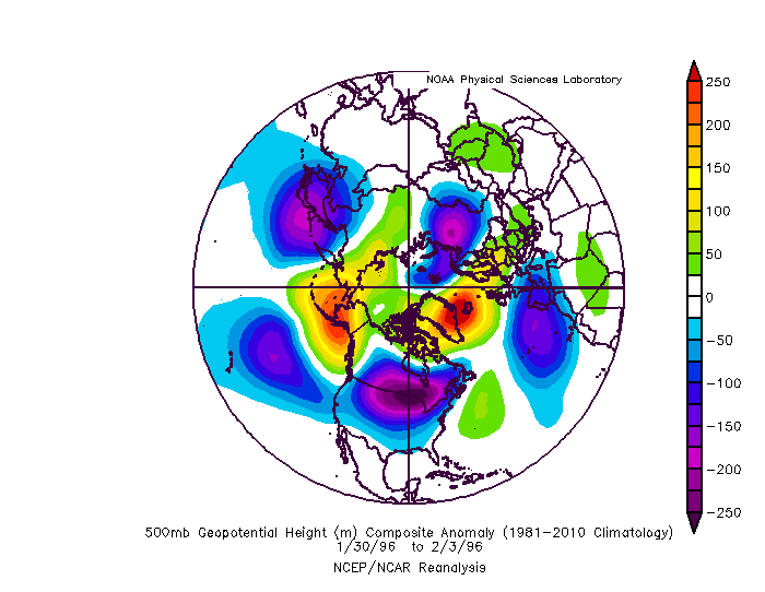
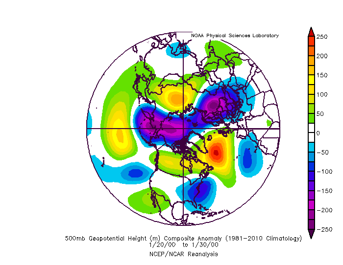
Well 1995/6 was the only example where we had a blockbuster winter on the whole...because it was the only nina where we had persistent blocking all winter long. So you have to judge things in proportion...if we only get a 10 day blocking period you can't expect to get 50" in that 10 day period. But if you get 10" of snow during that 10 day period...that was a productive period. But if you end up with only that 10" all winter the winter as a whole seems bad, but that blocking period wasn't the reason. The problem in a nina is we tend to do REALLY bad without blocking. So the whole rest of winter is often a barren wasteland outside those blocking episodes. Especially in a moderate or stronger nina. We can sometimes get lucky with some smaller snows in a weaker nina without blocking. So with that out of the way...limiting this to more recent 1980 onward ninas for Baltimore...and looking at periods of prolonged blocking...we had some very transient blocks that lead to an isolated minor event over the years...but lets look at just longer periods of blocking during moderate or stronger ninas. Links to the H5 January 1985 there was a major blocking period in January that lead to 2 snowfalls 2.5" and 3.7". This one you could argue underproduced...it was a pretty darn good looking pattern that only produced 2 storms and pretty minor. But it wasn't totally wasted it did snow twice during the 4 weeks of major blocking. But this was probably the biggest underproducing blocking period of the list I looked at. It was brutally cold at times though. https://imgur.com/Mwy5pwN the blocking broke down in February and a more typical nina pattern took over and that was winter over. March 99 really produced with several snow events in our area over a 2 week period. https://imgur.com/GVgexww We wasted most of the rest of that winter with a +NAO January 2000: this was probably the biggest over performer. We only had about a 10 day favorable blocking pattern that whole winter and we hit big time with 3 snowfall events across the area and 1 HECS. https://imgur.com/OexbcZJ December/January 2010-11: This one underperformed. A lot of bad luck. Somehow missed a miller a that took a weird curve and had a messy phase that screwed us over. We did get 2 snowfalls in January out of it, one advisory and one warning level event. So it wasn't a totally wasted period but we did miss out on the one HECS level event during this period...hit on that and it goes from slightly disappointing to epic. Oh well. Also...we tend to waste NAO blocking in December more then any other month...if you get blocking you would rather it later then earlier in winter. https://imgur.com/N8eM9FS Some notable weaker nina blocking periods that produced recently February 2006: lead to that one big storm...the pac ridge was REALLY flexing though and limited our ability to get anything more out of that period. March 2018: shame that block didn't come a month earlier but we did get one minor and one significant snowfall out of it even in March. The problem in those years wasn't that it didnt snow when there was blocking...it was mostly that it didnt snow much at all the rest of the winter when there wasn't blocking. As for 1996...There were 2 periods of extreme blocking that set off what happened. The first was early in the winter. It was actually fading by the time we got the HECS in January but the pattern was set in motion. We got several minor snows in December during the height of the block. This in Dec set everything in motion. But the second half of January the blocking faded and this was the only period where a typical nina pattern took hold and lead to our torch/melt/flood period. Then the blocking reloaded in late January/February and set off the second half of winter. That blocking would reload several times the rest of winter into April. If we were to get a repeat of that level of blocking that repeated multiple times all winter like 1996 we would likely end up with a very good winter again, nina or not. Not saying we necessarily do as well as 1996..there might have been some luck in there too...but we would snow quite a bit given the number of chances we would get with that kind of blocking all winter long (with the exception of 2 weeks in January).
-
We had a period of NAO blocking in 2013. Didn’t do is much good. Also a pretty good period in 2016 but it was cancelled in the means by extreme +NAO periods. Also March 2018. Blocking has been rare lately yes. But there are enough examples not to automatically assume its solar. I’m not saying it’s not. Just that we can’t say for sure.
-
MJO plots are all over the place because there are multiple waves sending conflicting signals...but it seems day 10-16 the wave out near the dateline becomes more prominent on the GEFS. That would be helpful tropical forcing for a change. The mean plot shows phase 6 because a wave back near the MC and the one near the dateline are battling each other in the means. But if the forcing near the dateline is dominant that may explain the change to a more favorable look. Or it's just a coincidence.
-
None of the models when on an island without any other support is a good bet, especially not at that range. There is a lot of moving parts in this pattern. We will see how it shakes out.
-
I wouldn't automatically attribute anything to just one factor without a lot more research and data. It could be the solar minimum. Or maybe its something else and its just a coincidence. Or maybe the solar minimum is just a part of the equation and there are other factors contributing also. There are way too many variables to just pin it on one thing. If it was that easy forecasting wouldn't be so difficult.
-
If you get just enough blocking it sets off a chain reaction that reconfigured a Nina look into a workable one. What I found was we actually do ok in a Nina if we have a cooperative AO/NAO. Problem is that’s not all that common. Nina tropical forcing tends to favor a +NAM state more often then not. But in cases where we do get help up top it can snow in a Nina.
-
I found your answer...damn you, you got me curious and so I had to go look. The precip and ptype you are looking at is for the previous 6 hour period. So you are looking at the skewT for the very end of that 6 hour period. At that time it is very obviously snowing. But if you go back and look at hour 192 there is a warm layer at around 700mb. That is pretty high up and close to the snow growth region. That would definitely be a problem. A small barely above freezing layer lower down could easily be mixed out by heavier precip. But if the snow growth region is warm...well that's a problem. Now...is that warm layer right, probably not. Because no detail is right at that range. But that is why the precip type is showing mixing. Its very likely sleet as the below freezing layer under the warm layer is pretty thick.
-
that's legit...not some bootleg transient ridge...straight -NAO...no chaser. And it really starts to build in the short range not some unicorn long range fantasy.
-
Mix precip and cold. It really is that simple. Problem is we are latitudinally challenged.
-
Dunno...from a quick glance the best lift is not in the dendritic snow growth zone...but that wouldn't fully explain it. Could be a thickness based algorithm. But wasting a lot of time trying to figure out a very specific detail of a op run at that range that has no chance of being completely accurate is a waste of time anyways. If this was 24 hours out then we could try to parse that...and obviously the simple answer is its a mistake. Why...I don't know enough about their precip type algorithms to say. I don't really use those things to tell me what is going to happen anyways.
-
I wouldn't waste time looking at soundings at that range.
-
That was just one of the factors contributing to my extreme lack of confidence in seasonal forecasting lately. Or at least my own ability to make a seasonal forecast. I am sure there are those with a better grasp of things then me. But between the QBO acting erratically, a lower solar minimum then we are used too, an overall warmer profile then we have ever had, and some very unusual SST configurations we have never seen before...I don't feel confident in anything.
-
Yup...and if anything goes wrong our website is Jay’s Wintery Mix.
-
Xmas 6z Gefs
-
I do think climo is getting more hostile, whether that is a shorter or longer term trend I dont want to start that debate here, but the last couple years also skewed that worse because we haven’t been in a favorable pattern too often. Models are getting better. When were in a really awful pattern they shouldn’t show fantasy snow. Go back to March 2018 and Dec 2018/Jan2019 the last time we had a decent pattern and there was lots of fantasy (and some actual) snow.
-
It’s a long shot but it’s the best chance we’ve had in a long time. Low bar lol. Doesn’t seem to be a lot of wiggle room. We need perfect spacing between systems. Ji was complaining we don’t even get fantasy storms to track anymore. At least he had one run to look at.
-
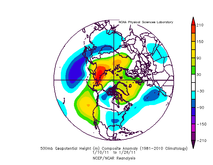
Where was she living at the time. Westminster had 11” from that storm. I could see given the circumstances calling that a blizzard! January 2000 is a fond memory but not for the same reason as most. I was manning the weather station at PSU Hazleton the day before that storm hit. I remember looking at the vapor loop and comparing it to the guidance and it just wasn’t matching up. I Kept running the loop and thinking “why wouldn’t that just come up based on the flow”. I convinced my friend of such. I can’t remember the guys name, he replaced Jon Neese when he left psu, but me and my friend were driving the meteorologist who came in to check on the station crazy. He was dismissing it out of hand “No chance the models are that wrong at such short lead”. He didn’t even want to look at what we were trying to show him. Everyone else was focused on the long range progs for what would be the superbowl storm 5 days later. The next day we didn’t even have to say a word. We walked in and just looked at him and he said “I know don’t say it”
-
You are analyzing details on a 150+ hour op run way more than I will. There is a threat. That is all there is to say at this point. Details will bounce around a lot. But it's going to be a fine line. There isn't a whole lot of wiggle room here.
-
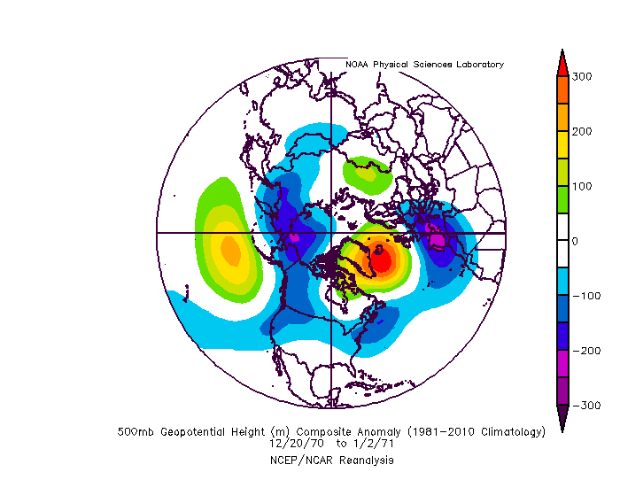
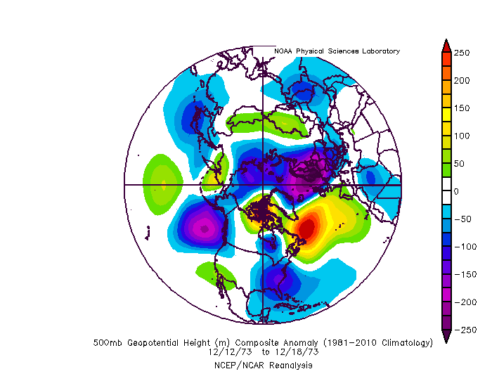
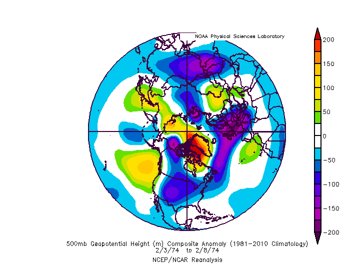
The rest featured some form of high latitude blocking...some of the more memorable storms or periods in this set... 2 storms during the holiday period in 1970. One a minor event, the second a 4-8" storm around the cities and more NW. an 8" storm in Dec 1973 a 6" storm in Feb 1974 I don't think I need to bother posting the 1996 look.... 3 storms over 10 days in January 2000 The psuhoffman storm and a minor event before it
-
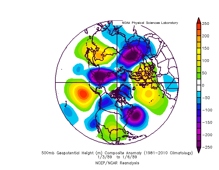
This was the one anomaly where it did not feature any high latitude blocking...a 3" snow to rain event in January of 1989. But it did feature one of the craziest atlantic bombs I've ever seen which acted as a substitute for a block.
-
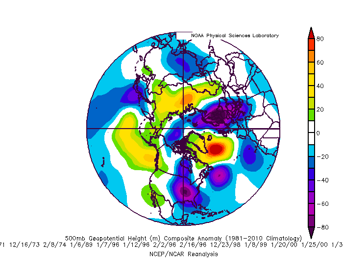
@losetoa6 so for anyone interested in what our snow profile looks like during all snowstorms of 2" or greater during a Nina that peaked at -1 or lower...(this year probably bottomed out around -1.3 This is the composite of all those storms at BWI
-
boom Ji will be happy... naw who we kidding
-
@frd There often is a lag time to enso's effects and so I am less optimistic than DT that a rapidly declining cold enso will help us much before March. But...it's a pretty small sample size of rapidly declining cold enso episodes and so it is hard to draw much of any conclusion. He could very easily be correct. I hope he is. I do think march is a wildcard either way. Many Nina's that were totally garbage up until March featured a cold/snowy period in March. It is not universal...1989, 2008, and 2012 were all in the analogs I compiled to this year and were wall to wall garbage winters with no help in March. But 1956, 1976, 1999, 2017, and 2018 all featured a turn to colder with some snow late. I guess "unsure" would be the best way to categorize my feelings on what impact a rapidly collapsing nina will have on our snow chances. Can't hurt though. What I would bank on more then that is simply getting some good high lat blocking before then and not having to wait for a March save. We have scored some good snow periods in Jan and Feb in a Nina but we needed blocking to do it. That's why the current signs up top are so encouraging imo. @CAPE @losetoa6 It's been quite a few years since I did my nina study, I think it was before 2017, so I wanted to refresh my memory. I also expanded my snow study to include all 2" or greater storms at BWI in Dec-Feb during Nina's that peaked at -.1 or greater since 1950. I excluded March because that is kind of a wildcard in a Nina and that is a long way off. Let's hope we aren't heading into March needing to avoid a disaster. Even expanding down to 2" I only found one storm out of 23 (and it was a kinda pathetic 3" to rain) during the 11 moderate or stronger Nina seasons that didn't feature a lot of high latitude help. It is true that a lot of those storms did feature a period of less hostility on the pac side also...but the fact there are almost no examples of even minor snows without blocking to me indicates the break in the pac puke pattern was an effect of the blocking helping to press the TPV out of western Canada or Alaska where it will tend to set up shop and sit otherwise as a response to the central pacific ridge which is a direct effect of the nina. But get a block somewhere in the AO or NAO domain and you can squeeze that feature out of there just enough...retrograde or squash the pac ridge temporarily, and make it work.
-
For my full study only warning level. I did look at more snowfalls a while ago for Nina specific years...I think I started the cutoff for that at 2". You have to draw the line somewhere...there are way too many 1-2" type events to do a deep analysis of all of them. At least when I am not getting paid for any of this and have to do it on my own very limited time. If I was getting paid to do it I would gladly analyze every cartopper we ever got and break down the pattern. But honestly, its kinda a pathetic state of affairs that we are drooling over the thought of 1" of snow anyways...back when I started the study I was looking at "significant" snowfalls. Due to our lack of any snow at all recently what we call "significant" may have changed since then lol. ETA: including a lot of 1-2" events also would skew the results quite a bit since you can luck into those in a pretty mediocre or bad pattern sometimes...so you end up getting not very useful results.
-
I would have agreed a month ago. But the AO/NAO seem to want to play nice at times so far. This upcoming pattern is one that would probably work ok if it repeats in January or February. It could work out now but it had a better chance the deeper into winter we get.


