psuhoffman
-
Posts
26,285 -
Joined
-
Last visited
Content Type
Profiles
Blogs
Forums
American Weather
Media Demo
Store
Gallery
Everything posted by psuhoffman
-
The jump due north between 96-102 is odd imo.
-
Well that gfs run looked like one of the inside eps members. Low gets to the mouth of the Potomac. That’s way inside where we want.
-
Honestly I don’t look at a lot of that crap other then for entertainment sometimes. At some point more info, if it’s likely not better info, is just distracting noise.
-
The NAM wouldn’t have ended well. But it’s NAM at 84. That’s like the Gfs at 240. If it wasn’t over amped at that range I’d be shocked.
-
Icon is slowly trending more towards the other globals every run imo. It wasn’t long ago (last night I think) the icon was a primary with almost no secondary and a rainstorm to upstage NY and central New England after a brief period of WAA snow.
-
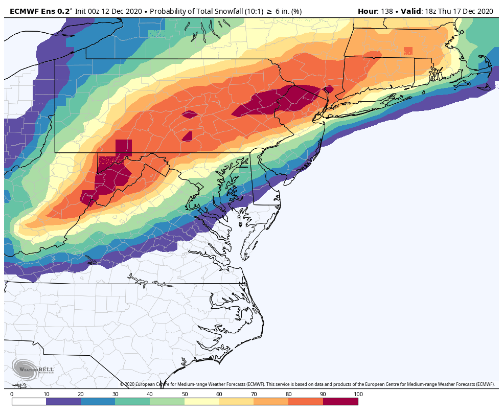
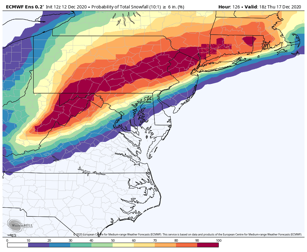
@WxUSAF just quick visual evidence of what I said. The edges tightened some due to some outliers falling off. But look at the 50% prob of 6” line runs. Almost identical at 12z to 0z. The probabilities of the 2 camps hasn’t changed much. 0z 12z


-

Central PA - Winter 2020/2021
psuhoffman replied to MAG5035's topic in Upstate New York/Pennsylvania
There was a bit of a freak out in the mid atl forum over the EPS looking a bit “inside” at 108 hrs. This really only matters to the SE zones in here but for them I’ll post what I said in the mid atl thread. Since the Eps is based on the op and typically supports it it makes sense it would have the same bias but I can’t say for sure. But Imo the reaction to the 12z Eps is overblown. It’s not as bad as it looks. It’s sort of an illusion imo. There are several factors that make that 108 hr panel look awful. There was always a camp in the EPS going back 48 hours that has a too far inside track v the cluster of tracks that would support a decent amount of frozen. From my analysis I don’t think the % in each cluster changed that much. Several factors made that 108 panel look worse. First a few if the inside runners are way inside this run. But it matters not to us if the track is up the fall line vs up the bay. Both are rain. Matters for Harrisburg I guess. The inside runners are deeper too skewing the mean. Second the timing tightened up. There is way less timing differences on the 12z v 0z so now there is one panel where you can see all the inside runners at one time. Third the timing changed by 3 hours so now that 108 panel catches the storm at its closest inland pass in VA where before most of the lows we’re still down in NC then off the MD coast. We didn’t have one panel on the EPS that caught all the lows at their ugliest look before. By my count if you look at all the panels and estimate (hard to do with some but this is close) there were 21 members out of 50 that were inside of a “frozen supporting track” at 0z. That doesn’t mean the others were all huge hits but tracks that should support a decent bit of snow into 95. At 12z I count 23 inside runners. So maybe 2 more in the camp we don’t want. But that seems like noise to me. I’m not saying an inside runner isn’t a legit fear here. Even up here that’s my fear. I don’t see any way this gets suppressed south. The trough goes neutral and starts to lift pretty far west. The whole flow is amplified. The block/50-50 are anchored a little north of the examples where we see something squashed to our south. Imo this is going to be a hit or too far north and rain. I feel pretty good about this ATT but still a long ways to go. But you know me if there is an “oh no it’s all falling apart” moment I will be the first on here warning about it. The 12z EPS wasn’t that imo. -
@WxUSAF I’m not saying an inside runner isn’t a legit fear here. Even up here that’s my fear. I don’t see any way this gets suppressed south. The trough goes neutral and starts to lift pretty far west. The whole flow is amplified. The block/50-50 are anchored a little north of the examples where we see something squashed to our south. Imo this is going to be a hit or too far north and rain. I feel pretty good about this ATT but still a long ways to go. But you know me if there is an “oh no it’s all falling apart” moment I will be the first on here warning about it. The 12z EPS wasn’t that imo.
-
Since the Eps is based on the op and typically supports it it makes sense it would have the same bias but I can’t say for sure. But Imo the reaction to the 12z Eps is overblown. It’s not as bad as it looks. It’s sort of an illusion imo. There are several factors that make that 108 hr panel look awful. There was always a camp in the EPS going back 48 hours that has a too far inside track v the cluster of tracks that would support a decent amount of frozen. From my analysis I don’t think the % in each cluster changed that much. Several factors made that 108 panel look worse. First a few if the inside runners are way inside this run. But it matters not to us if the track is up the fall line vs up the bay. Both are rain. Matters for Harrisburg I guess. The inside runners are deeper too skewing the mean. Second the timing tightened up. There is way less timing differences on the 12z v 0z so now there is one panel where you can see all the inside runners at one time. Third the timing changed by 3 hours so now that 108 panel catches the storm at its closest inland pass in VA where before most of the lows we’re still down in NC then off the MD coast. We didn’t have one panel on the EPS that caught all the lows at their ugliest look before. By my count if you look at all the panels and estimate (hard to do with some but this is close) there were 21 members out of 50 that were inside of a “frozen supporting track” at 0z. That doesn’t mean the others were all huge hits but tracks that should support a decent bit of snow into 95. At 12z I count 23 inside runners. So maybe 2 more in the camp we don’t want. But that seems like noise to me.
-
I’m late to the party and probably 150 posts behind...but it hits the wall of confluence and turns due east just in time to save DC north. Keep in mind euro is typically the most amplified model (sometimes a little too amplified) so seeing it slightly north of other guidance (initially) isn’t shocking.
-
Central PA - Winter 2020/2021
psuhoffman replied to MAG5035's topic in Upstate New York/Pennsylvania
It’s gonna snow. That’s the analysis. Happy holidays. -
Can you see the pine tree I lit up in my backyard from the bottom of the ridge?
-
How’s northern NH?
-
The euro does tend to be over amped sometimes. Seeing it the most amplified isn’t unusual. If it nudges towards the other globals just a bit it’s huge.
-
There was a nice 4-8” storm in late January but not much after Dec.
-
Omg they’re still using the same maps I was looking at in the weather station at PSU in 1997. Anyone got the Nogaps and NGM while we’re at it??? I remember how frustrating those things were when a MB marking was blocking something you needed to see. SMH
-
For people asking about this one thing or that. Getting a big snow here is like a golf swing. There are 20 parts and any one can screw the whole thing up. It’s never just one thing. And these variables play off each other. Stronger 50/50 can offset a less ideal upper low track. That same 50/50 and a further south upper level pattern and it suppresses the storm to our south. I could do this with a dozen other factors and variables. Unfortunately there isn’t one thing you can say..that’s it. Just look at that. It’s how they all play off each other that matters. The upper level longwave patter (high latitude blocking) put us in the game but those details determine big hit v close miss.
-
The upper level low associated with the primary system to our west starts to go neutral and lift a little too far west for an ideal h5 track. But we can do fine in that scenery if we have great confluence locked in by a 50/50. But if the 50/50 were to weaken or lift out sooner we would need that to change or an icon type solution is possible.
-
It is but also a slightly slower more amplified system out west so other variables could offset. We will see. Minor changes have significant impacts when your worried about a 50 mile shift at 5 days.
-
Heavy rates needed to mix cold down stay to our SE. but it’s trending to everything else.
-
Gfs doesn’t quite get the heavy qpf far enough NW to intersect where it’s cold enough NW of the fall line. But it’s been clueless on this wave (as it was the wave last week that gave some light snow to southern VA).
-
Yea icon is way weaker and further north with the confluence. Less 50/50
-
@PhineasC icon says you should stay Monday then head back to NH
-
@Amped honestly the whole h5 track of the initial system is not ideal even on runs that show a big hit. We need that monster 50/50 to offset that. Or we need the system to trend south with the track of the initial system.
-
Icon h5 isn’t that significantly different from other guidance. But it never cleanly transfers energy so the h5 keeps lifting with the primary v turning east to consolidate with the coastal. But up until that last part the h5 track looks similar imo.