psuhoffman
-
Posts
26,285 -
Joined
-
Last visited
Content Type
Profiles
Blogs
Forums
American Weather
Media Demo
Store
Gallery
Everything posted by psuhoffman
-
12knam isn’t a big event even up here imo. 2-3 before and 1-3 after a flip imo. 3k would be fun though. Good 4-6” front thump then 4-8” back. Go with the 3k.
-
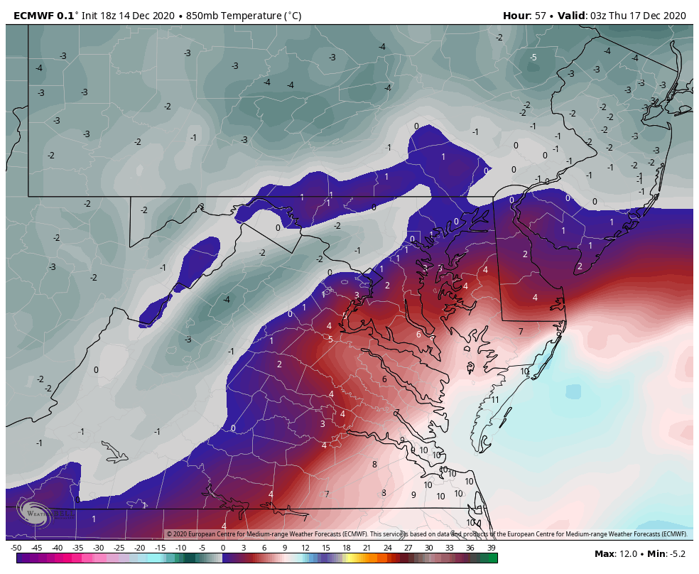
This is where our area starts to lose the thermals on the WAA side of the storm. It's a step back on this part. The red line is the 850 but like you said at this point the layer is isothermal from 850 down so its pretty much the rain snow line there...you can see what qpf came before the transition...you can estimate how the area did...northern zones hold on 1-2 hours longer...south of DC gets very little snow before going to rain. 1z here is about the worst look for the thermals. This is the NW extent of both the surface and mid level warmth. I have estimated the rain and sleet lines here by tracing the 925 and 850 0 lines. 2 hours later by 3z the temps are crashing and I would estimate everyone NW of 95 is going back to snow or has already. There are some pockets in the zone of subsidence NW of the developing banding of warmth but if they are between heavy bands at the time your not missing out on much accumulation anyways...point is I think we can assume from 3z on anything that falls is snowfall from 95 NW SO this last plot is the qpf that falls after that...and this is where the bulk of the snow comes from. This looks great...I would sign up for it...but I do NOT like living on the deform love as 90% of the storm. That can disapear real quick if things don't come together right. But the euro has been remarkably consistent with that in our area so maybe... so there is good and bad here...but again I am nervous relying almost entirely on the back side. Even up here its only about 3-4" before a flip to sleet...the other 14" if gives me is from the deform. If that happens GREAT but my rule is usually to treat that as bonus. Anyways... hope that helped.

-
@high risk The NAM does sometimes sniff stuff out. It nailed the sleet fest coming from range in March 2017 when all the globals had snow. But the problem is, its wildly inconsistent at range...which is to be expected for a model designed to handle convection and meso scale banding. It is useful in showing thermals better and a better detailed representation of what the storm might look like...but wrt synoptic level general things like track, at range it's hard to take any one run seriously because you don't know what it is onto something or when it is just on something. @BTRWx's Thanks Giving You NEED to stop with those crap snow depth maps. I have no idea how they are calculated but over the years they have been just as garbage as the weenie weatherbell ones. They end up seeming right for the same reason some of the trolls here do...because we fails so often. The models are often wrong and thigns shift worse. And when that happens...it makes a map like those look good. But whenever a storm actually does what the guidance says...those bust low. WAY LOW. I will give you one example just because I looked at the soundings. The NAM one you posted shows Westminster with 3" of positive snow depth. But they get about an inch of QPF with all levels at or below freezing. They get another .8 of QPF that is obviously sleet from the sounding. The surface is below freezing the whole time. Heck even if the whole storm was sleet that would be more than 3"!!! That is just crazy stupid. Now maybe the storm shifts even further NW and then 3" in Westminster isn't a bad idea. If the track actually penetrates inside the mouth of the Potomac...that would be trouble for up here...but a track like that NAM had over the southern Bay in up the eastern Delmarva supports a big snow (with some mixing yes) up here...and the model shows that if you look at the actual soundings and hour by hour plots...then that depth map shows something completely different. THis is not the only time but its a current example of how that map is just WRONG.
-
I think their being harsh but I noticed your not really predicting anything much different then most but it’s the tone. Instead of focusing on a he positives for the parts of the region that get snow you are focused more on the fail aspects. I get crap for that too sometimes. No one likes to hear depressing news. Even if they know it’s true.
-
Thanks. That valley is probably about your elevation. ~800’. They are still out having a blast. Made 3 snowmen so far and a huge snowfall fight with the neighbors kids and now working on a snow fort. They have been asking everyday when it’s going to snow ever since it started getting colder.
-
Roads are fine. My driveway did cover during the last very heavy burst where rates were like 2”/hr for a time but melted immediately after. And I’m close to the highest spot in the county.
-
It’s rare but sometimes just the 300 feet between my ridge and the valley below matters. In the zoomed in you can really see the difference.
-
First snow day for the kids
-
Finished with just under 3". Went down to pick up a work packet from my son's school, which we can literally see in the valley about 300 feet below us from our backyard...and there was visibly less snow. Crazy...
-
Wanted to point something out when watching the details on the op runs. It’s not just the track of the surface low but also how much of an inverted trough feature there is. 12z euro track was slightly west but it was colder because there was less inverted trough and primary remnants. That trough prolongs and enhances the easterly fetch. We want the coastal to close off a circulation at low and mid levels as quick as possible. A stronger inverted trough delays that some and kills us with an inside ideal track.
-
I dunno what the meltdown was about the navgem track looks perfect!!!
-
it was really coming down the last hour https://ibb.co/TPfQhmZ https://ibb.co/pQk4vCX https://ibb.co/Lk327YX
-
Naw when things are going sideways you hug whatever you can.
-
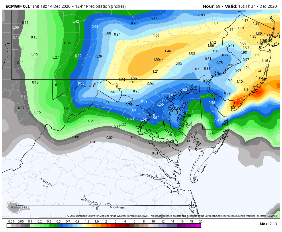
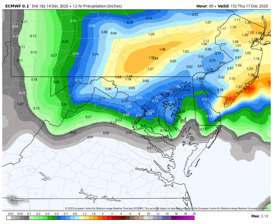
The GFS is by far the lowest. It will adjust. Every other model has a qpf max of 2”+. There will be 20” totals from this storm it just won’t be over us. The Max is likely up in PA. That’s our problem...not qpf.
-
Driveway caving
-
I’m so close to cool
-
Heavy snow. Ground caving.
-
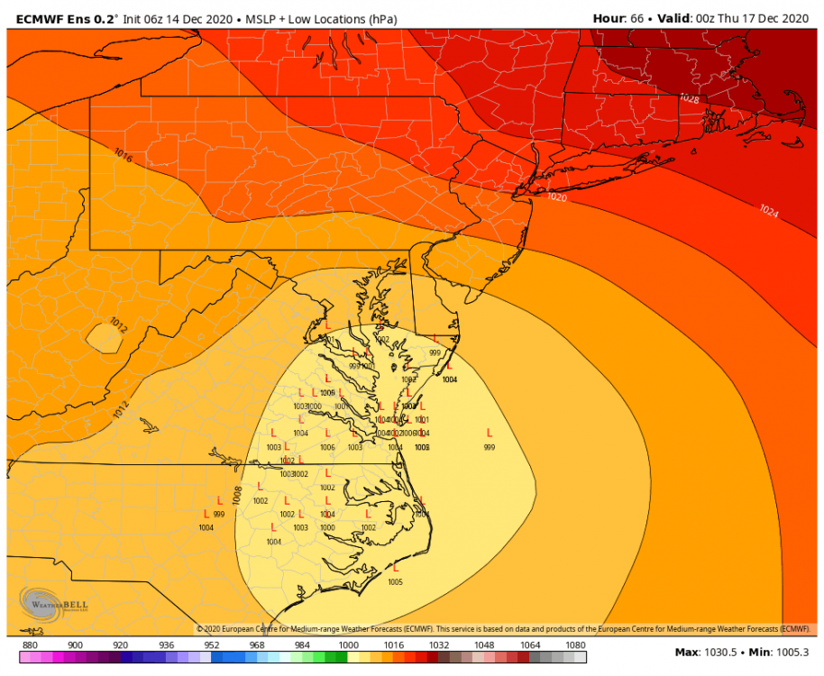
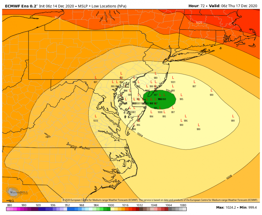
I thought the 6z op run was ok but the eps was kinda ugly. A LOT of inside runners that track the low pretty far up the bay before the turn east. This was the first ensemble run where I cringed when I looked at the slp plots.
-
All snow here now
-
Slush bombs mixing here. 35
-
I wouldn’t worry about the NAM. I can’t tell you how many times in the past few years at 36+ hours it’s given me snow on the back end of a storm that ended up no where close because the system was way more progressive. Gonna get some sleep.
-
SREF looks good lol...I mean if were going to bring up a bad NAM run at range...might as well mention a good SREF
-
The main globals have been crazy consistent with only slight adjustments given the time scale for the last 3 days. Some of the meso models will bounce around like this at range. Now...if the globals were to shift to a NAM like inside cutter...that would be a major jump.