psuhoffman
-
Posts
26,285 -
Joined
-
Last visited
Content Type
Profiles
Blogs
Forums
American Weather
Media Demo
Store
Gallery
Everything posted by psuhoffman
-

December 16-17, 2020 Winter Storm Obs/Nowcasting
psuhoffman replied to WxUSAF's topic in Mid Atlantic
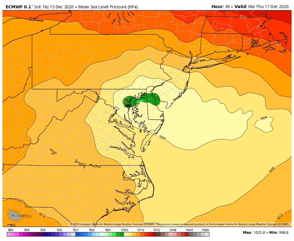
Ok I think some are over analyzing a run where the low tracks OVER BALTIMORE!!!! Hopefully it’s wrong. But come on. If the low actually tracks from Richmond to Baltimore to Wilmington anyone from 81 east and south of York PA is screwed. We know that. This isn’t that complicated. Just hope that track is wrong. If you get the 12k NAM or GFS track with the euro storm presentation we get a big storm 95 NW. unfortunately the best guidance at this range we have looks like poo. No one mentioned both the RGEM and HRDRPS look awful and had their worst runs at 18z. I am rooting for the gfs but...it’s the GFS lol. Other then the GFS and 12k NAM everything else I saw continued to degrade at 18z. -
December 16-17, 2020 Winter Storm Obs/Nowcasting
psuhoffman replied to WxUSAF's topic in Mid Atlantic
Because the surface isn’t all that affected and that map counts anything where any layer is somewhat close to freezing as snow. They are awful. -
December 16-17, 2020 Winter Storm Obs/Nowcasting
psuhoffman replied to WxUSAF's topic in Mid Atlantic
It’s a torch at mid levels which is expected when a low tracks over Baltimore!!!! Those maps are lol. They have be at 16” but when I check the temps at all levels I can only find about .4 qpf that’s snow even up here. -
December 16-17, 2020 Winter Storm Obs/Nowcasting
psuhoffman replied to WxUSAF's topic in Mid Atlantic
Ugh so much for a good trend 18z. Worst euro run we’ve had by far.
-
December 16-17, 2020 Winter Storm Obs/Nowcasting
psuhoffman replied to WxUSAF's topic in Mid Atlantic
Unfortunately snow growth (crystallization) can only happen in the DGZ and once it melts under there the rain can only freeze into sleet. That deep of a cold layer just guarantees sleet v freezing rain. -
December 16-17, 2020 Winter Storm Obs/Nowcasting
psuhoffman replied to WxUSAF's topic in Mid Atlantic
The mid levels have a very March 17 look on the 3k NAM -
December 16-17, 2020 Winter Storm Obs/Nowcasting
psuhoffman replied to WxUSAF's topic in Mid Atlantic
@mappy -
December 16-17, 2020 Winter Storm Obs/Nowcasting
psuhoffman replied to WxUSAF's topic in Mid Atlantic
warm layer at 750 mb -
December 16-17, 2020 Winter Storm Obs/Nowcasting
psuhoffman replied to WxUSAF's topic in Mid Atlantic
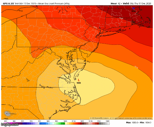
Yes...track might have been slightly better but it continued the trend of tightening up the mid levels so there is a much tighter thermal gradient NW of the low track. Verbatim you go to sleet for about an hour in the afternoon...then back to snow for several more hours before you lose the thermals right as the best precip is moving out anyways...you might get a little light snow on the back end but that looks mostly northeats of you. But this is a pretty good run...80% of the qpf is probably snow. The warm layer never makes it further west then that ridge you can probably see from your house just west of leesburg. Adjust 10 miles east and you stay all snow. Actually...if you take the euro and adjust it to this track we would both get a pretty darn good outcome. Even closer to the cities would do well. That is probably what we need here...slight eastward track adjustment and this new idea of a better closed circulation to be correct. -
December 16-17, 2020 Winter Storm Obs/Nowcasting
psuhoffman replied to WxUSAF's topic in Mid Atlantic
It is...we got the trend we need for a late save...no more further westward adjustment to the track...and a continuation of the better mid level close/pass to promote a tightly wound system by cutting off the easterlies sooner. A more tightly wound synced up "phased" system at all levels will cut off the easterlies to the west of the low center and prevent that warm layer from blasting as far inland... But like i said we need the west trend of the track to stop for that to matter...if we can keep the track east of us AND get that trend to continue we could save a decent outcome here. Maybe no Ji level win but something most of us would take right now. -
December 16-17, 2020 Winter Storm Obs/Nowcasting
psuhoffman replied to WxUSAF's topic in Mid Atlantic
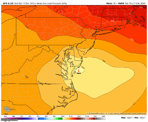
Well...I think the inside track is becoming pretty locked in. But there have been some developments with a better H85 and H7 pass that are causing a more tightly wound thermal gradient with this storm and could also make the possibility of some banding as the low departs real. If we were to get the west trend of the low to stop and perhaps adjust just a slight bit back east...but keep those factors...some places could still do well. It's possible. But one warning...the west trend of the low track continued with 12z guidance. And the mitigating factors I listed above are maxed out. For example..on the euro there is a time about 3z when the low is literally on the east side of Baltimore and yet its snowing here. A couple hours later that snow rotates through the north side of Baltimore with the low over NE MD. But if that track adjusts any further west...well nothing else is going to matter...you aren't going to get snow if you are UNDER the low or east of it. So we need both the better mid level depiction of the 12z guidance...but also we absolutely NEED the west trend of the low track to stop NOW. Get a slight east bump in final track, which is very possible...trends don't always continue right to the end...at some point guidance could pick up on reality...and maybe even over amplify some. Get that east adjustment by 50 miles and keep the better mid level look and maybe places closer to the city still reach warning criteria. Southeast of DC yes...this just isnt the right setup and I don't see anything that saves them. For 95...its getting tough but there is still an outside chance if those things I said above break right...namely we get a slight east adjustment to the track AND the better mid levels. For people NW of the fall line...very much still in the game for a decent event so long as expectations have be reset. Those crazy numbers we were throwing around 48 hours ago are gone. The track is just too far west for that...but we could still pull out a decent event if things break our way. But like I said above...its troubling that we continue to see a west shift every run on the guidance and we are completely out of any breathing room now. IF there is any further west adjustment then its a fail for everyone east of the blue ridge and south of PA. -
Surface track was west...mid level results were better due to a better close off of the mid and upper level circulations earlier. That would lead to a tighter wound system...which is good if you have an inside track. There was a lot to like in the 12z GFS I was just pointing out that the larger trend of the track shifting west did not halt, that was the bad.
-
This is what I saw
-
Death by a thousand paper cuts. The high has trended SLIGHTLY NE of where it was days ago. The confluence in the NE weakened some. The 50/50 moves out slightly faster...and the storm slowed down 6-12 hours...increasing the spacing between the two and allowing for more ridging in front of it. I was always bothered by how far west the upper level trough was going neutral and starting to lift, we needed all those other things to offset and they went the wrong way. Some problems that I think the globals had a hard time seeing at range...that are now coming into focus (NAM saw it from jump) was the without a closed off mid and upper level circulation (ERS talked about this) there is nothing to stop the easterly flow north of the low from blasting way NW. Add in all the warm water and that is shifting the boundary west...and the low track right with it. I don't think there is any one thing to point to that did this...it was a lot of things that all went the wrong way...and that was partly why this was a slow bleed and not a sudden shift. No one factor suddenly got a LOT worse...they all just degraded along the margins a little. IMO what hurt us most was just a little too much spacing between the 50/50 combined with the trough digging in a little too far west then lifting instead of amplifying along the east coast. The other factors like warm water and less confluence and shallow cold could have overcome that if they had all trended perfectly...but the warts in the overall synoptic setup required a lot else to go perfect...for a time it seemed like they all would.
-
I don't agree. There are meso scale features to any run that might change the exact snow/ice output on some snowmap for a specific location. But the trend killing us is the NW shift in the low track. It's been relentless for 48 hours...it started as a very slow bleed that was hardly noticeable run to run but it where there...and its accelerated the last 3 runs. The 12z guidance shifted west again...across EVERYTHING i saw. Some of the runs had a better snow result for a specific spot due to a meso scale feature within the run...but across the board the track was a bad move. And that is way more important because those meso details will change every run and be a nowcast thing...but if that track keeps adjusting west it won't matter. Every shift west reduces the chances of all those meso features to help much. I think we have reached the stage where a lot of people are grasping at straws and holding on tight to whatever little speck of data they can find to give hope. I get it. I really do. But I just can't do the blinders bad analysis thing.
-
I don't know if I really view the GFS as a reversal of the trend. It shifted the low track NW. That is the trend...all our other problems come from the fact the low keeps trending west with every run. Within that the GFS improved on some meso features that helped us out. An earlier close of the mid level circulation and such a more tightly wound system. And that worked for us wrt snowfall. But that is a meso detail within the larger scale...and on the larger scale the trend was another shift west in the low track. It is fine to celebrate the good things about this GFS run but we shouldn't overlook the bad. If the trend in the track were to halt NOW and adjust east slightly we are still close enough (NW of 95) to salvage things if the details like early close of the mid levels and banding and fast WAA thump go our way. So its good to see some of that on the GFS. But we need the larger trend with the track of the system to stop or it wont make any difference. If this tracks up west of the bay no one in here is going to be happy no matter how the meso nowcast details shake out.
-
The dry slot is now a problem here because the track has shifted NW. It didn’t get dryer it just shifted the heavy qpf up into PA! That dryslot is because the best WAA and fgen have shifted northwest by then because the track shifted NW. It wouldn’t be snowing where that dryslot is anyways because there is a huge mid level warm layer and that’s why the dryslot. To simplify the WAA lift stopped because the cold has been scoured out and is no longer resisting and forcing the warmth to lift over it. Again there will be 20”+ totals with this storm. It’s plenty wet. Those totals just won’t be anywhere near us as the track keeps shifting north.
-
@mappy 6z euro was good if you take it in a vacuum but it again nudged everything NW as every run has for 2 days and even up here we are out of any wiggle room. Any further adjustment and we will lose both the WAA front thump but especially any back end as the best forcing for that keeps shifting north. If the trend stops right now we are ok but any continued west shifts of the track today and we are in trouble even up here.
-
I don’t want to be overly critical but over the years it seems they are often a little slow to adjust to changing guidance. This works both ways.
-
The QPF is lower because it tracks the storm up over CAPEs house and into southern NJ. That pushes the best forcing further NW towards state college PA. That’s the perfect track for them to get crushed but it’s getting inside where we can expect to get big totals.
-
@Ji trends. It was significantly worse then 18z. The bleeding hasn’t stopped. I’d like to see a suite of guidance where we’re not must grasping at things like “well that wasn’t as much worse as I feared”.
-
?
-
Gem products shifted west and warmer this cycle. That’s all I’m taking away.
-
Yea but those precip plots are “previous 6 hours” and the temps are at the end of the period as temps crash on the back. Need to see the temps at 48hrs to know if it’s better or your seeing it AFTER the warm surge. Would imply at least some snow on the back but how much hard to say without that info.
-
It knows