psuhoffman
-
Posts
26,285 -
Joined
-
Last visited
Content Type
Profiles
Blogs
Forums
American Weather
Media Demo
Store
Gallery
Everything posted by psuhoffman
-

December 16-17, 2020 Winter Storm Obs/Nowcasting
psuhoffman replied to WxUSAF's topic in Mid Atlantic
You’re pretty far from any radar do the beam is pretty high plus you’re the last corner of our sub to get precip in most events...lot of waiting. -
December 16-17, 2020 Winter Storm Obs/Nowcasting
psuhoffman replied to WxUSAF's topic in Mid Atlantic
@Ji euro caved to NAM. Track improved but mid level thermals suck 6z 0z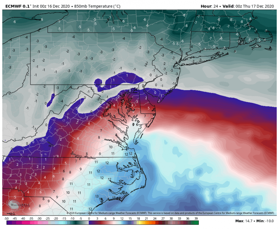
-
December 16-17, 2020 Winter Storm Obs/Nowcasting
psuhoffman replied to WxUSAF's topic in Mid Atlantic
What’s weird is the Euro run at 3k now typically does a very respectable job at picking up meso scale features and warm layers imo. If the NAM is correct it will be one of the worst short range busts I’ve seen it suffer in some time. Some places it has getting 15-20” in southern PA might not hit warning criteria if the NAM is correct. Hell the Euro gave me about 14” (and it was legit not a snow map fantasy) and I might not see more than a couple inches of ice if the NAM is right. Trouble is it’s hard for me to bet against a warm layer. It seems they typically win. -
December 16-17, 2020 Winter Storm Obs/Nowcasting
psuhoffman replied to WxUSAF's topic in Mid Atlantic
The hrrr has similar track to nam but isn't doing this crap That’s why I asked about the HRRR. I’m familiar with the NAM the good and bad. I don’t know much about the HRRR. But one one going to embarrass itself here. This is only a 17 hour forecast and look at the difference from that 0z NAM plot. and the HRRR keeps trending colder every run. -
December 16-17, 2020 Winter Storm Obs/Nowcasting
psuhoffman replied to WxUSAF's topic in Mid Atlantic
@MillvilleWx what has better scores at 12-24 hour lead the NAM or HRRR? -
December 16-17, 2020 Winter Storm Obs/Nowcasting
psuhoffman replied to WxUSAF's topic in Mid Atlantic
The frustrating thing is the track is great. Stays offshore. But I think we’re stuck in a no win here. The runs with an offshore track have a worse mid level phase. That’s why they don’t tuck up the bay. But without closing off their mid level circulation even with an offshore track they blast the warm layer inland. The tuck up the bay runs have a much tighter structure due to a closer mid level circulation but the track to the bay screws us. That said the inside track with a better closed circulation/tighter thermal profile seems to be the better result if your NW of 95. It was disheartening to see both the 12k and 3k NAM pull the same identical garbage. -
December 16-17, 2020 Winter Storm Obs/Nowcasting
psuhoffman replied to WxUSAF's topic in Mid Atlantic
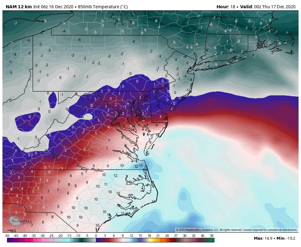
NAM track is good. Stays off the coast. But it’s mid levels are awful. Blasts a warm layer way inland despite the further east track.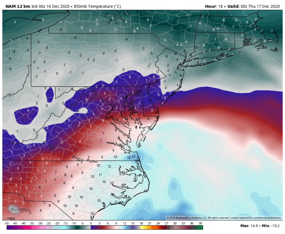
-
December 16-17, 2020 Winter Storm Obs/Nowcasting
psuhoffman replied to WxUSAF's topic in Mid Atlantic
The preponderance of evidence says that’s about what happens. But I suppose there is enough random odd pieces of guidance that don’t that maybe there is that miracle chance. But that would be an awful big error for this range. Jan 2000 level fail considering the advancements in NWP since then. -
December 16-17, 2020 Winter Storm Obs/Nowcasting
psuhoffman replied to WxUSAF's topic in Mid Atlantic
lol -
December 16-17, 2020 Winter Storm Obs/Nowcasting
psuhoffman replied to WxUSAF's topic in Mid Atlantic
It was a shift east and better...but this low track is just comical for us -
December 16-17, 2020 Winter Storm Obs/Nowcasting
psuhoffman replied to WxUSAF's topic in Mid Atlantic
I’ll hug this -
December 16-17, 2020 Winter Storm Obs/Nowcasting
psuhoffman replied to WxUSAF's topic in Mid Atlantic
Ah new peramiterization same flawed math. I kid of course. If not for the euro the gfs would be the gold standard. -
December 16-17, 2020 Winter Storm Obs/Nowcasting
psuhoffman replied to WxUSAF's topic in Mid Atlantic
No but in January with a colder airmass and less scolding water temps the low likely doesn’t track as far west. -
December 16-17, 2020 Winter Storm Obs/Nowcasting
psuhoffman replied to WxUSAF's topic in Mid Atlantic
I’m not doubting it but I thought they changed the core when they upgraded to the FV3 version. Being non hydrostatic v the old GFS you would think the physics have to be different. Yet it has some of the same weaknesses from what I’ve see so far. Makes me wonder if there is something in the methodology or data assimilation of NCEP behind it. -
December 16-17, 2020 Winter Storm Obs/Nowcasting
psuhoffman replied to WxUSAF's topic in Mid Atlantic
It’s the only guidance that shows me all snow. But that’s simply because it can’t pick up on mid level warm layers. Never has. Although I guess this is the new GFS lol. But I find it suspect that EVERY other nwp is wrong on that warm layer. -
December 16-17, 2020 Winter Storm Obs/Nowcasting
psuhoffman replied to WxUSAF's topic in Mid Atlantic
If only I could believe the GFS lol -
December 16-17, 2020 Winter Storm Obs/Nowcasting
psuhoffman replied to WxUSAF's topic in Mid Atlantic
Only good thing about sleet is it makes the snow harder to melt. If we had a nice snowcover I wouldn’t mind a sleet storm to cover and protect it. -
December 16-17, 2020 Winter Storm Obs/Nowcasting
psuhoffman replied to WxUSAF's topic in Mid Atlantic
Definitely not a heavy snow sounding. Maybe that’s after that band moves through is the subsidence. -
December 16-17, 2020 Winter Storm Obs/Nowcasting
psuhoffman replied to WxUSAF's topic in Mid Atlantic
if we could get the NAM track with the euro thermals we would be good lol -
December 16-17, 2020 Winter Storm Obs/Nowcasting
psuhoffman replied to WxUSAF's topic in Mid Atlantic
Ugh that’s kinda a nightmare for my area -
December 16-17, 2020 Winter Storm Obs/Nowcasting
psuhoffman replied to WxUSAF's topic in Mid Atlantic
We’ve had snow events work with less. You’re 100% that the look up top isn’t the stone cold killer perfect analog look. But it’s a good enough look to make a snowstorm realistic but we would need some help. The perfect look up top makes it where more factors can go wrong and still work. This setup we needed more to go our way. Not enough did. Even with the 50/50 vacating had that rogue SW not dug the trough west of us we probably got a decent snow event. But a few things went wrong and it’s Dec and the block wasn’t perfect enough to offset. But I would take this look all winter and roll the dice! Might not get a hecs but we would probably get a couple warning events with enough chances with a similar pattern imo. -
December 16-17, 2020 Winter Storm Obs/Nowcasting
psuhoffman replied to WxUSAF's topic in Mid Atlantic
Agree. The spacing was just a little off. Even with the SW that dug the trough that was pointed out had that 50/50 been a little slower to vacate, but a huge gap opened up and this storm is taking advantage of the ridge to cut inside. It happens. It’s December. But I’ll say this...and I’ve been too busy to track this and post in long range so I took a break but the -AO NAO does not look like a transient think. I think we finally are getting our winter where blocking will be a significant feature. If we get a -AO winter and the pac isn’t a disaster (so far it’s meh but not awful) and still manage some awful single digit snowfall then the “somethings” wrong argument has more legitimacy. Blocking won’t guarantee we get great results but it should (absent a dumpster fire Pac) get us some snow events. If it doesn’t it’s gonna get ugly in here. -
December 16-17, 2020 Winter Storm Obs/Nowcasting
psuhoffman replied to WxUSAF's topic in Mid Atlantic
At least I’m not worried about ground temps. I still have snowcover. -
December 16-17, 2020 Winter Storm Obs/Nowcasting
psuhoffman replied to WxUSAF's topic in Mid Atlantic
If that track verifies I guarantee you Philly doesn’t get that much. Maybe a few inches. NYC won’t get prolific #s but their saved a reasonable storm because it does eventually hit the brick wall and turn due east. There is a block. But it exerted its influence ~100 miles too late for DC to get a big snow. CAPE pointed out, and was right, that the block is centered a little north of ideal for us. Still it was good enough to work if other things went right. We don’t need PERFECT. But the trough digs too far west and pumps ridging ahead of it and the 50/50 is just a little too far NE to prevent it. NYC is far enough north that it barely saves them. At least to an extent. The big totals will be in central PA and North of them. -
December 16-17, 2020 Winter Storm Obs/Nowcasting
psuhoffman replied to WxUSAF's topic in Mid Atlantic
Usually around 500mb or a little under that.