

psuhoffman
-
Posts
26,285 -
Joined
-
Last visited
Content Type
Profiles
Blogs
Forums
American Weather
Media Demo
Store
Gallery
Everything posted by psuhoffman
-
It looks like we might finally time up a pretty good pattern with our prime snow climo window. It’s been forever since we did that. I’m trying to be guarded. And expectations should be kept realistic. It is still a Nina. We’ve had -AO/NAO Nina’s before where we did ok but not GREAT. If 1996 happens awesome but I’d set the bar more realistically. Let’s just get a warning event or two into the urban corridor then sprinkle in some more minor snows here or there. Imo that’s a realistic bar if we get an extended -NAM state during prime climo. ETA: start to see signs the WPO vortex wants to anchor further west and allow a pna ridge or if the PV really gets obliterated and we see indications the AO will tank through to spring and that’s when we might start to dream BIGGER...for now in ecstatic simply to see real signs we should avoid a total dud this year.
-
I think that’s part of it. I also think guidance has been running too warm in general in the long range. The last 7 days was supposed to be a torch from long range. Guidance has a lot of good track rain storms in the 7-15 day period. It’s not like the snow mean is super high north of us. Most of that up there is from lake effect and a clipper or two. The storm track looks good. I have a feeling it will trend colder if the storm track is across the south.
-
There is EVERY indication this will be a -AO winter.
-
@WxUSAF Frankly you could pick any panel from day 5-15 and it’s a look we would have killed for at anytime last year!
-
Yes, it’s pretty good, workable at least, straight through. I just picked one panel. It’s also been backing off on the AK trough the last few runs which would help. It also, like the GEFS and GEPS, is retrograding the NAO block more and more into January. If the looks the globals are teasing are correct we should snow somewhere in the next 2-3 weeks. Problem is way too many SWs in the flow to pick out any one threat as THE ONE yet.
-
Close...

-
Btw there is a chance (which is typical) we are rushing this. It’s possible we get one of these waves in the next 13 days to hit...but it’s also true we usually do better as blocking regimes relax or break down. The guidance (all 3 majors) are building the -AO/NAO and even improving the pac some (which is linked) into early January. And given the evidence right now there is no reason to think it’s a fantasy. The AO and NAO have not been hostile this year. There is a chance our best window comes in January.
-
No 14 was neutral 15 was weak Nino
-
Thanks... I am going to straight up drop kick the first person who complains if we get a 6-10" snowstorm in the 95 corridor. It's a Nina. Expectations!!!
-
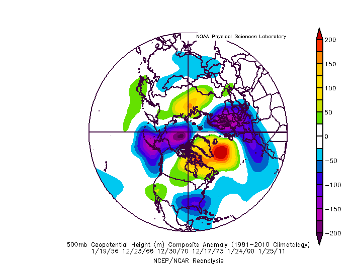
I think we need to stop focusing on getting the PERFECT pattern and look at what works in a Nina. We likely are not getting a picture perfect pacific pattern. Nor do we need the ABSOLUTE perfect block to get a snowstorm. We do if we want a HECS. But we likely aren't getting a 20" HECS storm either...there has only been 1 of those (1996) EVER in a Nina going back to 1900! But we have had plenty of warning level snowfalls in a Nina. This is the composite of 6 of the best Nina snowstorms since 1950 between Dec 15 and Jan 30 at BWI. I left off really early and after Feb 1 storms because our snow climo wrt what works is slightly different very early and later in the season. So these are good "models" for what works this time of year in a nina. All of these were warning 5"+ events at BWI and some of them were very nice ~10" events in our area. Here is what I take away from that look, and what has worked in past Nina's to get snow. Notice that trough in and around AK. No that is not ideal but its acting to suppress the pacific ridge associated with a Nina. In that regards...its actually helping more then its hurting assuming it stays centered WEST of AK. If it shifts east too much its a problem and we get flooded with pac puke. Centered west of AK and it damages the thermal profile of the CONUS yes but its not fatal. There can be just enough trough into the east to get domestic polar air into the northeast. It is what it is...you lose that trough there and the central PAC ridge goes APE and its all over...you get a trough in the NW and ridge out in the east. The -NAO is critical to this because it helps retrograde that trough out of western North America just enough to make this workable. Lose the -AO/NAO and the Nina PAC ridge can exert itself and that trough in AK shifts east into NW NAM and its last year all over! Notice also the NAO is centered east of ideal there. But what is critical to get that to work is to have SOME extension of the ridge west towards Hudson Bay. But...that said...there are some analogs in there where the NAO blocking is centered pretty far east (2000 is one recent example) and still managed to work out. There are also numerous other decent snowfalls...advisory in the city and warning NW that I didn't bother to include but that show a similar picture in terms of how to get snow in a Nina and what typically works.
-
It's too far east to get a HECS probably but we can get a good old regular snowstorm with blocking there. We focus way too much on the HECS look. That look is super rare...happens only a handful of times a decade and if were lucky a couple hit. But MOST, by a LARGE %, of our snowfall comes during good but not PERFECT patterns with slight flaws.
-
Yes that could change but I think we need to see it move that way in the next 24 hours. We’re getting to that range where the globals have been picking up on the general synoptic setups. We’re right at the lead time where the primary shifted south on guidance opening up the opportunity last week. I’m not sold on any solution yet. But it looks like there are possibly 4 waves between Dec 28-Jan 5 with blocking setup. They will all affect one another. Spacing and if they amplify into the 50/50 space. I don’t have a strong feel for how the specifics play out but I do think we would be incredibly unlucky to come out of that period without one decent snowfall. We can pick on the minor imperfections but fact is the look is plenty good enough to snow. Excellent AO/NAO. Strong STJ. Mediocre PAC. That should be good enough to get some snow imo.
-
It happens in extreme blocking. I’ve seen analogs like that. But it’s usually a fail for our area. Can’t say 100% sometimes crazy stuff happens but we want a the primary to be bottoming out at our latitude or lower to have a better chance.
-
The primary comes across too far north. It’s that way across all guidance. Unless that changes (it could) it’s inevitably a miller b screw job. We could eeek out some snow but it’s the setup where we watch north of us cash in. However, a bombing system the 28 helps the setup after.
-
When 2016 showed up at day 10 it was rain on the euro also. Same reason...marginal airmass. We are getting closer to the part of climo where marginal air masses should work with a good track.
-
Been a nice week up here...barely lost any snow all week. Some shots from Friday and today From my walk Friday my jebwalk with my 2 year old this evening (at her insistence)
- 616 replies
-
- 10
-

-

-
If it obliterates my healthy snowpack only to replace it with a fraction that’s not exactly a win. I’d rather simply avoid the 12 hour torch and keep my current snow lol. But for those not with snow OTG I can see the excitement.
-
I think he over reacted to 2 VERY good euro op runs yesterday and one EPS where it took a big move in that direction. He was probably expecting the EPS to continue trending and the op not to take a crap the next run (although I would argue it’s a great setup day 10 for something early next year). I think he jumped the gun and got emotional maybe but there was logic behind his thoughts. Even with some degradation today the look is close to a big storm look.
-
Euro doesn’t dive enough energy far enough south to do much for out Xmas wave idea. Just some flurries after the front unless you’re in the extreme NW parts of the region.
-
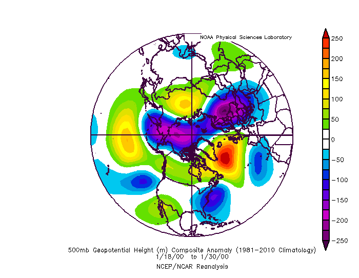
That’s the H5 from the end of January 2000.
-
Wrt my h5 post from 2000 above one key to getting that to work is the extension of the east based NAO ridge west into the Hudson Bay region.
-
It’s not our most typical look but it’s worked before
-
My bad
-
My bigger worry for the post Xmas threat is a miller b screw job not cutter. I’m talking about the Dec 28 period. Anything after that is way too far out to worry about.
-
Not surprisingly Imo. That disconnect between the mid levels and the surface while limiting big totals on the southern area also created a HUGE expense of significant snow. The initial WAA fgen snowfall band set up for a time where you would expect with that surface track. But the mid levels ended up driving the forcing WAY further NW then typical.


