

psuhoffman
-
Posts
26,285 -
Joined
-
Last visited
Content Type
Profiles
Blogs
Forums
American Weather
Media Demo
Store
Gallery
Everything posted by psuhoffman
-
I would argue we have been in the regime for a while already and are just going through a typical relax/reload period now. That happens. It's normal. But we already saw the AO tank and the NAO go negative. The spike up was very temporary and then it immediately starts to tank again. The base state of the AO right now is clearly negative. And the guidance is suggesting this next drop will be more significant then the last. I would also argue that the period we just came through repeated in January/February would likely have better results for DC/Baltimore. But IMO we have been in the pattern for a while...this isn't a matter of waiting for some long range fantasy. We are just waiting for the details within the general pattern to line up to get a specific threat.
-
if the blocking gets delayed yes...when we start to see the pattern get pushed back in time it often is a sign the guidance is not handling the progression correctly. But in this case the issue is some saw the blocking go up in the long range and got excited and jumped on the first waves to come along as the blocking was in its infancy stages. That isnt our MO. We tend to score snow on the backside of blocking regimes once the blocking has fully matured or is relaxing. The blocking itself isn't getting delayed...just the idea that the threats to come from a blocking regime are likely to be later not sooner.
-
I know from coop data Manchester got about 7" on Xmas day 2002.
-
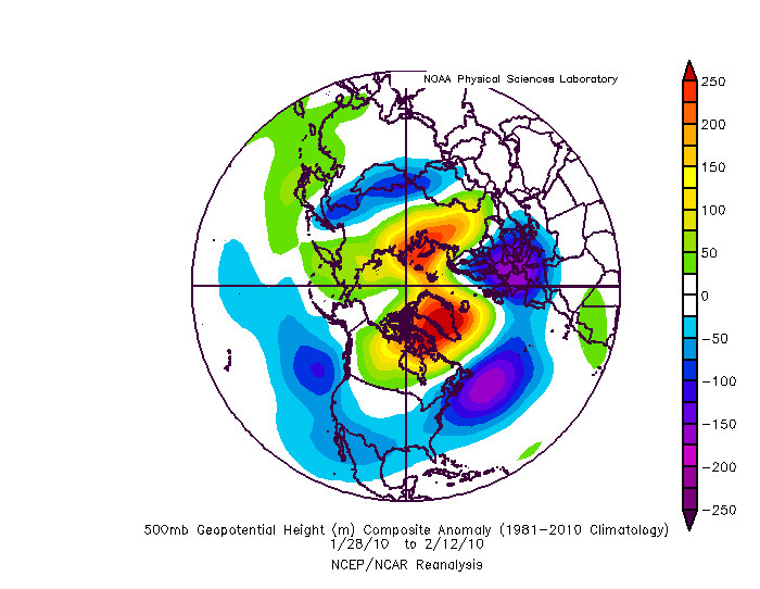
careful there are some really good analogs in there...but some complete duds also. 2002 and 2013 are in that group!!! Obviously we would all take 1958 or 1987 again... most of the others were some version of mediocre but given our expectations coming we probably should be happy with mediocre.
-
In terms of long term patterns they have been each holding their own. Gefs won in Early Dec when EPS was going torch mid dec. EPS has continually tried to shift the WPO trough east too much. Gefs has been handling that better. This version of the Gefs has been much better IMO but I can’t say without doing a more objective controlled study of its “schooling” the EPS.
-
GEFS looks good after the New Years cutter. Better block location and just enough ridge in western Canada and the SW.
-
If we get the west based NAO block on all guidance in January and NOTHING comes of it...then I will join Ji in trolling the bleep out of this winter. But I do not think that happens. If that blocking is real we will be tracking threats soon. I know its hard to wait.
-
some similarities...the mid and upper levels open up and allows WAA to go wild and the storm lifts a little too far north. But its a minor adjustment from a big hit. But the real takeaway is we have the exact same pac pattern there...the difference is the blocking has moved into the western NAO domain and matured and so that next wave from the same starting point cannot cut like the 2 before it. This is all typical. We do better once blocking is established or is relaxing...not as its developing.
-
Impatience... I think some expected something to happen between Xmas and New Years
-
He jumped the gun...got excited probably. I do think the pattern he saw is coming...he was just a week wearly. I am claiming Jan 5-15th as our window.
-
To illustrate the blocking is just starting to get into a position to do any good here...but look at the ridge already in the northeast. It’s not in time to save the New Years threat if that energy comes across in one piece and amplifies to our west. but look at a few days later... This look should offset the pac. Actually in this look I want the pac shooting energy in otherwise that’s a dry look likely. It would be very difficult to get a cutter in this look once the blocking gets established in the western NAO domain. Would be hard to get enough ridging in that flow.
-
The pac isnt good so we need the blocking to be perfect. I think were jumping the gun also...saw the block go up and jumped on the first waves coming across. But the block is initially just an extension of the WAR but with each wave break it retrogrades more and more into a classic NAO block. The problem is at 150 as the trough is amplifying out west the wave break from the storm after xmas is just starting to get the ridging to retro further west...but there is already ridging in the east at this point. And the blocking is frankly still SE of ideal ATT. It's the wave break from the new years system that retrogrades the block into the perfect position that could then be expected to offset the pacific. A WAR that extends into the eastern NAO domain isn't going to cut it. We need a west based rex block to offset the pac. Luckily the guidance shows that...but not until after the new years system. I do think there is a chance that trends colder into some kind of mix event though if we can get the energy to eject in pieces.
-
True but I haven’t seen much of a typical Nina response yet.
-
I saw one pure STJ wave. Others were polar jet in origin. But that’s ok when they eject into the plains they can pick up stj moisture.
-
Keep in mind also...when you look at the ensemble means at day 10-15 because of timing differences on waves details get washed out. The blue in the west is not a big huge trough...its from pacific waves crashing in every couple days. We need those waves...hopefully one of them ends up our snowstorm. There would be short periods with some PNA ridging in between imo...but its getting washed out by the lower heights of the waves crashing and the timing differences between members.
-
EPS look out west is more problematic. Not a total deal breaker...we have had some good snowstorms in that look but its not as common as if that trough stays centered off the west coast a bit more allowing just a little bit of PNA ridge into the southwest. Perfect blocking can erase a lot of issues in other areas though. I wonder if we saw this....would we pick apart the less then ideal pacific?
-
Is it...the blues out west look pretty close to this... Remember blocking changes what works out west. Without blocking that wouldn’t work. With blocking you want that trough off the west coast to kick everything along and promote enough ridging over the CONUS to prevent suppression. If we had what we think of as a ideal pac with great blocking everything would get squashed. That’s a cold dry look. On the plot you posted I don’t see a disaster. The WPO vortex backed off enough to allow some epo ridging. The system south of AK is far enough south not to flood pac puke across. It’s part of the flow not detached. I’d like a little more pna but it’s not bad. If we have blocking. Look at my response above. I think some are looking for the “ideal” pac but what is ideal changes based on other factors. It’s a balance. What’s on one side changes what we want on the other. A full latitude EPO/PNA ridge at the same time as a -AO/NAO is really rare. First of all you almost need the tpv to either drop into the US or completely vacate our side to get that. And when we have gotten that mid winter it’s tended to be a cold dry look. Think Jan 1977. Imo the snow mean hasn’t responded yet because after the New Years storm it’s dry. And that’s to be expected with that blocking look. The New Years period is the HA storm on the front end as the blocking goes up. The wave break from those 2 systems help get the block into our canonical location. Once there though waves will likely slow down over the CONUS...blocking. We would then need the blocking to start to relax some. Or...the Feb 2010 option when a really strong stj wave attacked the blocking aided by a trough off the west to promote enough ridging (and the wave was strong enough not to shear out) to get that moisture to attack the block. But waves will likely be less frequent after the blocking establishment
-
Day 10 That’s a lot of red in the right places
-
One last observation. The runs that show snow around New Years do so by splitting the energy out west. There are multiple SWs crashing in next week. Runs that keep them separated and bring them out in pieces are further south. If they consolidate into one amplified trough out west the storm cuts.
-
Trough is way too amplified too far west. Pumps ridging ahead. No confluence. Cutter. But a whole lot of higher heights up top by day 10. I know patience is difficult but after the AO/NAO bottoms out and starts to relax is our favored time.
-
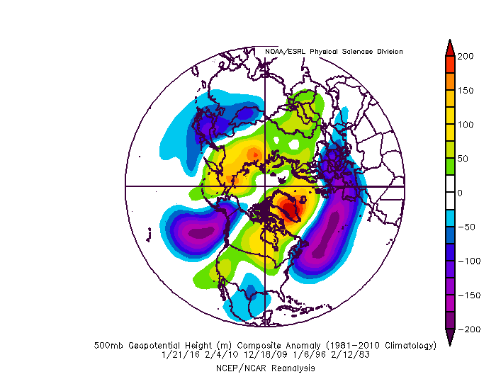
Those are the big 5 storms
-
@Ji Just sayin maybe we should let this play out. The blocking is just establishing itself next week. With each wave break it retrogrades more into a canonical blocking regime. Both the TPV and SPV look to get obliterated soon. We typically score after the blocking peaks not before.
-

-
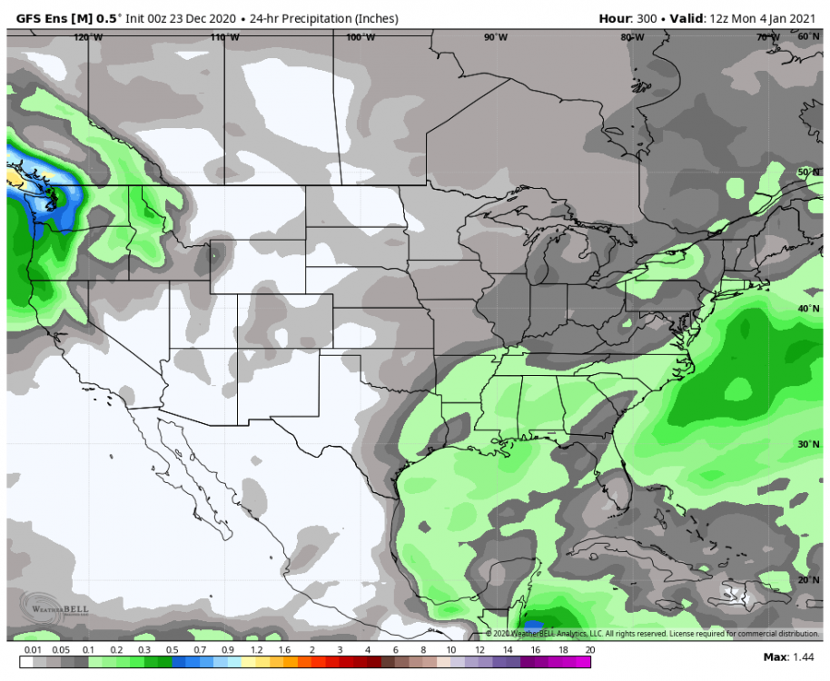
Not hating the mean precip distribution during that same period either
-
Finally starting to see the temp anomalies we need showing up.


