psuhoffman
-
Posts
26,285 -
Joined
-
Last visited
Content Type
Profiles
Blogs
Forums
American Weather
Media Demo
Store
Gallery
Everything posted by psuhoffman
-
We will see. I think given the stable pac jet we are unlikely to get much cross polar flow. Maybe the SSW shakes things up. But leaving that aside I am very curious to see what happens if we ever get the N pac trough to pull back with the blocking far enough west to get the trough into the east. History on that says it should work. That a direct flow from the Yukon even absent cold for them would be cold enough to snow. If it isn’t that’s a bad sign for the damage that’s been done to our snow climo. If we need an arctic air source to get snow anymore that eliminates about 50% of the warning events from my historical case study!
-
If the N pac trough crashes into the west it’s over for a while. But last time long range guidance did that and we freaked out it quickly pulled back and we ended up tracking a legit threat. If that pac trough backs off some things become workable quick. But yea so long as that trough is centered over AK were in trouble.
-
For arctic cold yes. Need epo ridging. Historically we could snow fine without that. The majority of the warning events in my case study happened with temps near 32. Some above 32. A lot mixed at some point. Most of our snow historically wasn’t cold smoke. I do wonder if more recently the pacific isn’t becoming more important if warming has rendered domestic non arctic origin cold in effective for snow chances. That’s just speculation at this point.
-
Ji isn’t chasing car toppers and 1” events. And I kind of get it. He likes the thrill of the chase. The model runs that show some big hit. He isn’t in it for a cold day with snow showers.
-
You are totally right that he ignored other factors and focuses all on his baby the strat. Nothing is one thing in weather. It's so many variables working together...and when things are wrong its always more then one thing. But this is interesting to me...in the sense I am always trying to learn and this is an area I can definitely understand better. The N Pac vortex is definitely our most direct "problem" but I think it might be symbiotic to an extent with what he is talking about. I saw some posts from strat "experts" who implied that the anomalously strong vortext in the WPO and EPO domains are part of the process in getting a January SSW. Additionally getting a strong heat flux from the tropics in conjunction and you have the perfect setup to transport that heat poleward. Unfortunately we are in the way of that transport. There is some "evidence" of this on the 6z GEFS. This is a 5 day mean. From about 24 hours to 144 hours the N PAC vortex actually pulls back enough that we COULD have had a better outcome. And we might sneak in a snow event somewhere in there if we get VERY lucky...but the ridge over the northeast really screws it up. But that ridge has its inception in the tropics...if you go back and look at where a LOT of that heat got added it originated in the tropical pacific and was drawn up by the PAC trough so its symbiotic. But that ridge prevents systems from amplifying into the 50/50 region where it could help to retrograde the Atlantic blocking into a favorable spot. Instead systems cut way too far west and get stuck...and actually help to prevent the blocking from retrograding west. Basically because of that ridge in the northeast the block alignment gets systems stuck WEST of the block instead of UNDER the block. That gets the trough stuck in the west and cannot progress east UNDER THE BLOCK...like we want. I don't know how much of that ridge is amplified by the heat flux coming from the pacific...but whatever amount it is...it ain't helping that's for sure. So you are 100% right this is way more complicated then just saying its all about the SSW...but there may be a component here. Looking ahead...after 144 the N PAC vortex shifts east and that is lights out for a little while. It's obvious that the combo of the central pac ridge under the N pac vortex is going to create that pac jet problem...and its likely going to last all winter. But that N PAC is a net positive IMO. At times it shifts into AK and thats no good...but at times it has been far enough west to give us a shot. Mid December was a great example. It's centered far enough west coming up this week but that NE ridge...we just covered that. When the N PAC trough pulls back again...if the Block has shifted west enough and we don't have that ridge in the NE it could work. Looking out to the end of the run... Similar setup to this week...but this time the blocking has migrated far enough west to set up better alingment to the "blocking" to get the flow to progress east UNDER the block v get stuck west of it. This is still not a truly cold pattern...I don't think that is in the cards this year. The pac is not right...but a direct flow from the YUKON in mid January better work...and I mean this...if a direct discharge of domestic air from the Yukon (even absent cross polar flow) is no longer good enough in dead mid winter...we are in big trouble snow climo wise...and I am not having THAT debate on this just stating a fact. The issue is...does the blocking retrograde...and that is the thing. If that blocking remains more of a WAR we will likely get similar results. All the guidance says it does retrograde. And the way it progresses kinda makes sense it would...the PAC trough crashing into the west actually helps...its gets the trough stuck so far west for a time that it allows the WAR to retrograde on its own even absent much wave breaking simply beause there isnt strong low pressure stuck north of the lakes preventing it. But it all comes down to that...if when the pac back off again the blocking is centered in the western NAO domain we will get a good pattern. If it is still a WAR we won't imo.
-
Full disclosure I am not an expert of the strat so everything I’m about to say relies on stuff I’ve read about it from others I trust. But this might be a case of a blind squirrel finding a nut. I did see some evidence that the precursor periods to a SSW tend to be mild in the CONUS. On a very basic level it makes some sense. The largest source of heat added is the tropical pac. If that heat is being transported poleward we are kinda in the way. That’s just speculation. I’ve not seen enough on the “why” of the correlation just that it’s there.
-
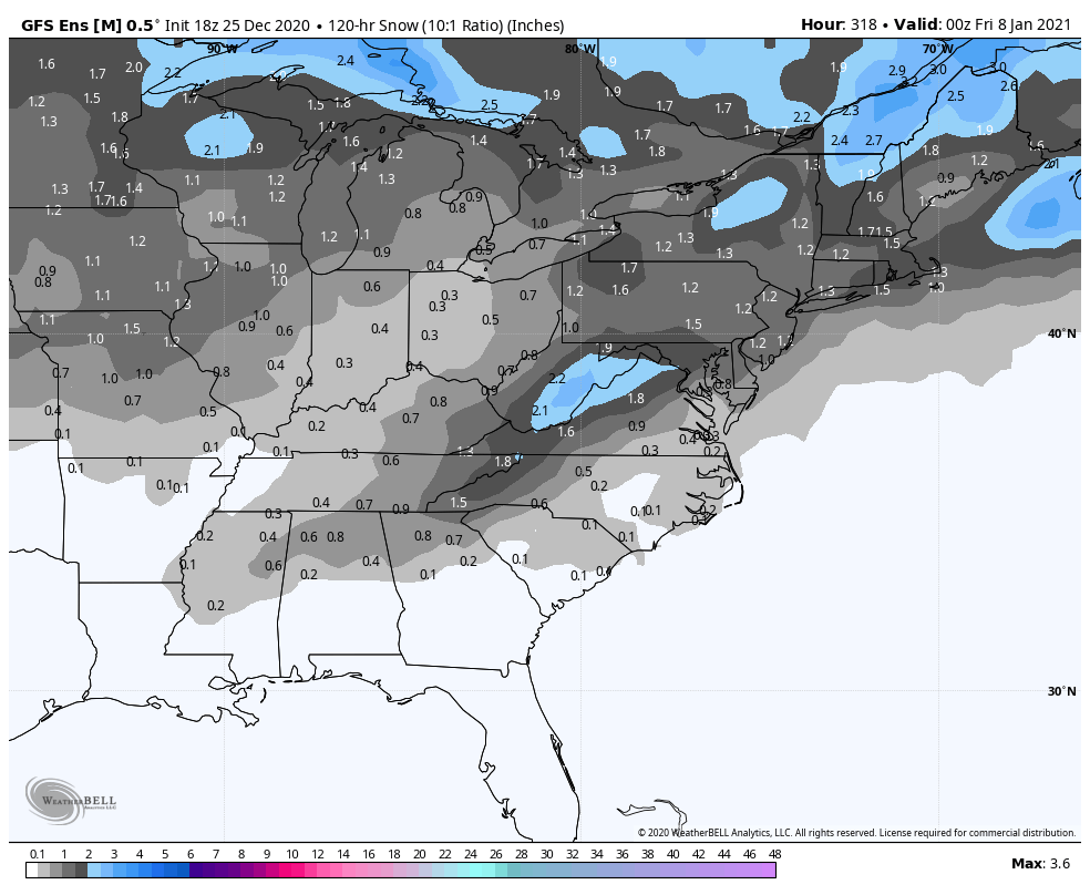
You’re being a little harsh. 2 big hits. 1 moderate hit. 3 minor snowfalls. 2 misses just to the NW. 2 misses just to the southeast or east. At that range that’s about all you’re ever going to see. The signal for a storm in that period is there. The odds of it being a big snow are maybe only 10%. But the odds of a warning snow snow in DC on any random day during January is less then 1% so 10% is a signal that there is a chance there. Maybe only a 10% but all of our eventual snow starts as a low probability when it’s in the long range. And 90% will never amount to anything. But 10% will.
-
This is the first time a hint of a signal in the snow means showed. It’s weak but for something centered day 10-11 this is about the best you’re going to get.

-
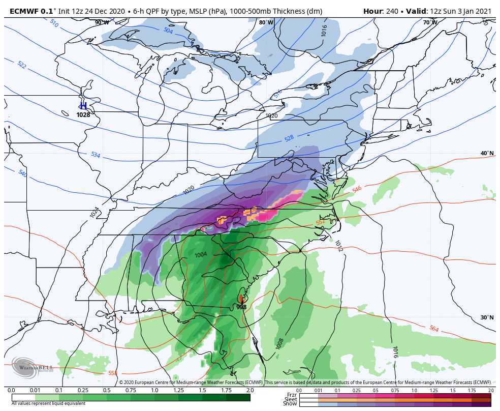
There was always a longwave passage about that time. Exactly how the short waves within the flow behaved was all over the place. A shotgun of cutter, sheared out, fish storm, suppressed...so there was no clear signal other then at h5
-
Were not in that kind of shape. I said around Xmas last year we were headed for a historically bad year. I was so confident in that I didn’t even bother to get my snowblower out of the shed and tune it up. While it may not look awesome right now we’re not in that territory Imo.
-
Agree with all this but I wouldn’t characterize the 2018 March block as transient. It started as a classic WAR in Feb then slowly retrograded from each wave break first to an east based block near Iceland around Feb 28 to a classic west based block then all the way to a Hudson block by March 10 then it reformed as a Greenland block mid March and did one more cycle into April. It was pretty classic it was just too late to do is a ton of good. Although we did great for that late all things considered
-
I think there is a connection to the cold problem with though. The runs that were getting the block further west we’re doing so because they were colder runs. Colder meant more gradient in the east and systems were amplifying east more and getting into the 50/50. Then the wave break from those lows retrogrades the ridge further NW. It’s a symbiotic relationship. The storms are amplifying too far NW to get into the 50/50 space and kick start that process partially because there isn’t enough cold in the pattern to suppress the storm track. Instead the wash out or end up way west of where we need.
-
Problem is no cold. The blocking is doing its job if you look at the h5 SWs are getting blocked in the Midwest and washing out or forced east. If there was cold around there would be CAD and likely a transfer situation. But there isn’t. The surface systems will ride the thermal gradient and if that is way up in Canada systems will synoptic amplify in the west then wash out east. We could perhaps overcome the bad pac if there was some cold in this blocking regime but there isn’t.
-
Ironically I read some stuff back in 2019 that implied the SSW really screwed us that year. The heat flux precursor to the SSW disrupted the pretty favorable pattern setting in early January but we never got the benefits later as the SSW didn’t couple with the TPV.
-
He also thinks the cold does come east but not until 1-2 weeks after the PV disruption.
-
It could be, if it ever does fully migrate to AK, just a temporary phase. I’m putting some pieces I’ve read together but that look may be related to some of the precursors to the SSW.
-
Last time they did that in early December it was wrong. The vortex never fully shifted and the pattern never broke down. So I wouldn’t assume yet. But the trend the last 24 hours has been pretty brutal.
-
GFS/GEFS decided the vortex that’s been in the WPO domain west of AK is going to shift east into AK. If that’s true we’re toast.
-
That was an ugly run.
-
If I were where you are...I would feel the same way.
-
@Ji the difference with this euro run v 0z was the block anchored more in our classic spot v over NF allowing the trough axis to progress further east before stalling and doing the same fujiwara deal. But for that range they have a similar idea wrt progression.
-
Either get that NS SW out of the way, or behind it...really anywhere else but right on top and it’s a BIG storm.
-
@Ji the setup is nice but verbatim I don’t think that would turn the corner. The trough split and the northern SW is pressing down on the STJ one. Its a nice little event but I doubt it became a monster in the next frame. My interpretation isn’t 100% though, there is enough room that MAYBE...but it looked to slide east not turn the corner. But now we’re analyzing details when the whole synoptic setup will go through significant edits. I’ll say this about today’s runs. They all get a perfect SW track going after the New Years cutter. The cmc is poised for something around day 11-12. Euro has it. Gfs has 2 perfect SW passes but the problem on the GFS is just no cold at all. None. Zip. That’s a threat. Won’t lie we’ve wasted blocks because of no cold early in the season before. Later in winter blocks work more and more to produce enough domestic cold. We will see.
-
For the people
-
‘‘Twas the night before Christmas and all across the net, Ji was trolling cause the latest GFS was nothing but wet. Meanwhile the snow weenies readied for bed, hoping soon their winter dreams would be fed. Pictures of h5 plots with lots of high latitude red, played all night like a fantasy in their head. They told Ji to relax as he went full tilt to the max. That even though the operational was wetter, don’t worry the ensembles will look better. But Stormtracker knew our climo wasn’t a good bet, so he thought it over and decided to jet. But he’ll be back soon and we’ll all be together, to celebrate the blocking and our snowy January weather. The strat warm is coming and it will do the trick, by mid January flakes will be falling and things should get epic. So I say to you my friends as we wait for the pattern to get right, Merry Christmas to all and to all a goodnight.