

psuhoffman
-
Posts
26,289 -
Joined
-
Last visited
Content Type
Profiles
Blogs
Forums
American Weather
Media Demo
Store
Gallery
Everything posted by psuhoffman
-
Pretty sure this temp profile will work fine
-
Deepest trough in the northern Hemisphere showing up over the eastern US. And a tiny spec of “Barney” for the first time in how long...
-
@Ji btw I am not saying I don’t dream bigger or a bigger result isn’t very plausible. There are some signs the Nina isn’t driving this bus. Maybe we cash in big. But I personally don’t like to set my bar that high and be disappointed all the time.
-
But we are still within a rather hostile pac background state and a healthy Nina to boot so maybe we need to be realistic. For me I feel like getting a good result “for a Nina” should be the goal. At least one nice region wide warning level storm and to beat median snowfall. That’s pretty rare for a Nina. History says when we get blocking in a Nina we get some snow and avoid a total dud winter but only 1996 had big results by non Nina standards. But 1996 is out there as “possible” but setting the bar at a 1/100 year type outcome for a Nina is kinda setting yourself up to be disappointed Imo. But you do disappointed well...it’s your defining characteristic so I guess roll with it!
-
Oddly the pattern better matches Feb 2010 then Dec 2010 on profs wrt blocking and trough location imo
-
It’s not way out at day 15 anymore. Guidance has actually been speeding up the progression. It gets even better after this
-
That or the wave after are my guess
-
@Ji the last 2 weeks we had a bad track because of the WAR. If we get a legit NAO block that issue will go away
-
Dude it snowed 15 days ago and I had snow-cover for a week. It hasn't been a warm winter. Its been a poor storm track winter I’m not talking about December. I’m talking about what’s coming. That 920 mb vortex cruising into the Bering is about to flood us with pac puke. That’s going to take some time to recover from.
-
The storm in front slides east instead of north which opens a crack for that to cut. Still I doubt it cuts to that extreme in reality. That was odd. And it’s 14 days away so I wouldn’t worry at all. In 6 hours we get a different solution.
-
I doubt anything cuts there. But out airmass at that point is still pretty abysmal. It’s going to take a couple waves and cold air drainage in the NW flow behind them to fix that. I remember a similar situation to this early in several blocking regimes that started with pac puke airmasses. Specifically I remember an exact clone to this discussion in early January 2016 when long range guidance hinted at a cutter...and we had this same exact exchange, and it ended up not cutting but was still rain. Because of the general warmth the primary hung on too long (not had there been cold but too long when we have a crap airmass) and it ended up a big old rainstorm anyways with a pretty good track. I could see that here. I agree with Wxusaf that we could luck into something with a perfect track. It’s not impossible. That block will likely keep us close and tease us. But until we get some cold into the east (probably around the 15-20th) it’s not going to be a high probability imo.
-
That model is hitting something
-
I never disagreed with THAT. I’ve been saying we have to be patient and wait for true blocking to establish and the temporary trough that crashes the west to pull back. My retort was to your post implying we need a total reshuffle and some huge EPO ridge and a breakdown of blocking to get cross polar flow. I think we just need to let the pattern progression we are on play out.
-
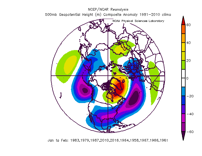
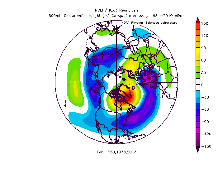
This is a composite of some blocking periods that centered the greatest + snow anomalies in our area. this is a composite of 3 years where the blocking didn’t do us much good but crushed New England. It’s subtle but look at the west and east. There are lower heights in the west on the NE comp and the trough in the east is centered slightly further northeast as a result. Note we don’t need some big PNA ridge with a block but we don’t want a full trough in the west either. Off the NW coast is ok but not crashing full in. One exception is March. Once wavelengths shorten in March that works. Some of our big blocking March storms had a trough in the west. I know this looks subtle but on a planetary scale us and NE aren’t that far apart so looking at a hemispheric map the differences seem subtle.
-
Lol they aren’t used to having to read the tea leaves of day 15 ensembles to look for their snow. Also a big block isn’t the holy grail to them that it is to us. They can do good but they can also get screwed. They also have way more ways to snow then us. And a lot of them up there are into snow pack building and frankly a blocking pattern isn’t the best for that. They aren’t typically cold, can warm up between storms, and if a storm gets trapped and hugs the coast they are susceptible to rain more in a blocking pattern. An east based -EPO with a displaced TPV is probably what they want most. 1994 and 2015 are their holy grail patterns.
-
SNE can do ok but they can sometimes be vulnerable to the storm being suppressed south depending on details wrt 50/50, exact block location, PNA ridge amplitude and location...the first 4 big storms in 2009/10 all went south of them. Then as a real kick in the sack the 5th HECS storm (the one that hit NYC and fringed our northeast area) cut due north and went to rain for them. They had a similar fate in 1987. They actually do better if there is more trough into the west coast as that’s more a miller b pattern. That’s what happened with the Feb storm in 2013. That block screwed us over. Missed that bomb then the March 2013 storm...I won’t go there. I’m pretty sure their big winter of 69 was the same, great block but with a western trough so that there were a lot of storms that started far enough north to really bomb off New England. That’s why we only had a decent but not great year in 69 despite amazing blocking. But some of our big storms from a west -NAO got southern NE too. I certainly wouldn’t want to be too far north in NE though. It all depends on the details once they set up wrt who exactly it favors. Fwiw the look I see on long range guidance now favors the mid Atlantic.
-
Yes...it won’t play out exactly like any op at that range but hypothetically that wave in the west at the end of the run has big dog potential. There is a huge vortex stuck to our northeast under the block. It’s got no where to go but track east under the block and there is cold in front of it this time.
-
I always check Ji’s posts before setting my emotional compass
-
My guess is around the 18-20th is when we start to rock. It’s possible one of those waves in the Jan 10-15 works but a long shot as the antecedent airmass is a train wreck. But the thermal profile over the conus will slowly cool in mid January with a flow out of northern Canada. Maybe we get lucky with something amplifying and doing the mythical “create your own cold” thing sooner but I think we have to be patient.
-
If my memory serves maybe the 11th or so there was a weird flip where the EPS tried to break down the blocking and had us all questioning our faith. The GEFS I think actually stuck with it but back then choosing the GEFS over the EPS was questionable usually. But it was only one or two runs before the better look came back. Ji was depressed in that post because we had been tracking what turned out to be a cold rain (we had some slush bombs mixed in up here) coastal because a primary ran up west and wrecked the temps. When the blocking first showed up a lot of us thought that was the threat. Ended up being a week later.
-
Often a season with an extremely weak TPV that features a mid season SSW the following winter features blocking also. This becomes even more likely if we see subsequent warning events after the main one.
-
Very Mongolian
-
We’ve played this game before...
-
Sometimes 2 things can be true.
-
I think the blocking will set up by day 10. But remember we have often had to suffer through a rainstorm after the blocking establishment before a snow threat. We had a big rainstorm around March 1 in 2018 after the block formed before the trough got into the east. Same in January 2016. The first wave to come isn’t usually the one because there is no cold in front of it. It’s usually later that we get a threat. Also once the block goes up don’t get shocked if waves suddenly slow down and we have to wait longer between threats. That’s all normal. Our greatest correlation to snow is a week or more after blocking establishes.


