

psuhoffman
-
Posts
26,285 -
Joined
-
Last visited
Content Type
Profiles
Blogs
Forums
American Weather
Media Demo
Store
Gallery
Everything posted by psuhoffman
-
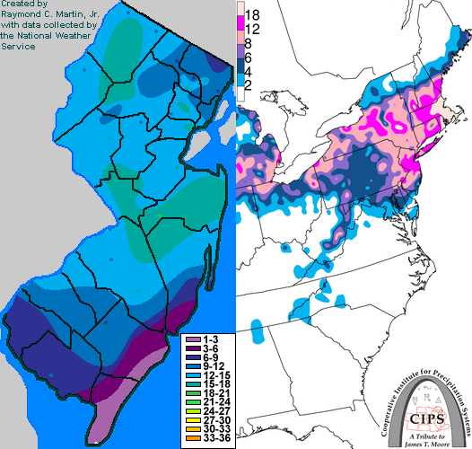
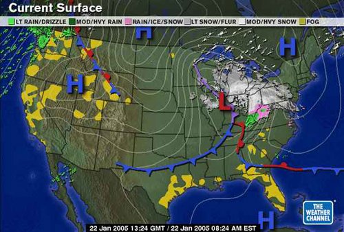
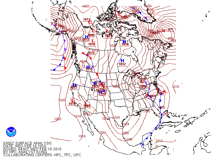
The thing is we need a storm to track to our southeast. And it needs to be mature enough as it passes our latitude to have developed a healthy CCB to have deep moisture transport into the cold sector to the NW of the track. how the storm gets to that spot isn’t really as important as that it does. That it passes somewhere near the NC coast to VA beach moving northeast and that it’s mature with a healthy CCB to transport moisture west to the north of the low by that latitude. Problem is it’s obviously easier to do that the further south the storm initiates. So a gulf system is our best bet. The miller b V2, assuming the transfer happens before it gets north of about TN/KY can be just as good if not better then a miller A. Less chance it misses to the east. But it really doesn’t matter what type the storm is so long as it ends up on the coast to our southeast. Problem with pure Miller B systems is it’s really hard to get a pure NS wave to get far enough south for that to happen. Usually unless there is a STJ wave to phase with a NS system will just jump to the coast at about its latitude which is typically too far north. I don’t get stuck on the A/B thing. Really the issue is just the storm tracked too far north. here are some examples though of a hybrid v1 and a pure miller B that did work for our area. Feb 10-11 2010 was a miller b hybrid v1. the northern stream system over OH phased with the weaker STJ system off the southeast coast but the transfer happened far enough south to develop the CCB in time for MD. Jan 22 2005 was a pure miller B that dropped 4-8” across most of MD and that’s honestly about the best we can expect from that type of system. It was a nice event if we ignore the 2 feet New England got lol
-
@Maestrobjwa hope this helps. There is some debate about what is a B v A/B Hybrid or even between A v B and I do not claim these definitions to be any definitive authority. Just trying to explain and have no interest in that debate. Here I will describe each then in the next post I’ll explain why some work better then others Miller A is simple, a pure southern stream system that originated near the gulf coast and comes up the east coast. A pure Miller B is a northern stream system that transfers its energy (jumps) to the coast. The jump often happens due to the system meeting resistance as it approaches the Apps and CAD and so it jumps to the baroclinic zone along the coast. Path of least resistance and it this case simply transferring energy and redeveloping. Hybrids can come in 2 versions. One version is a northern stream system that dives in and phases or transfers energy to a southern stream wave along the east coast. A second version is a southern stream wave that initially tracks north into the TN or OH valley before jumping to the coast
-
-
Yup only ran once a day, 12z, and didn’t come out until 7pm.
-
I dunno the euro has been a big red flag to me. I’ve never really gotten invested in this. Comparing the runs at 12 and 18z the euro made sense. The upper low keeps trending further and further NW. There really wasn’t much of a surface wave along the coast until close to our latitude. That band of heavy previp all the way from the coast wrapped around the upper low looked less likely then the split due to weak to almost non existent forcing in between the developing coastal wave and the upper low. The NAMs now look like the euro. The precip shield blossoms just to our north as the coastal finally deepens enough to produce better moisture transport and lift but we needed the quick thump snow idea. Maybe if we see the surface system trend more amplified sooner or the h5 more elongated towards the coast and less consolidated. Right now there is a big area with not much mechanism to get lift in between and that’s where we are.
-
Whose house has the snow magnet near the northern tip of Fairfax County?
-
That’s the wave I was talking about. Not only did the 12/30 SW kick it but that wave escaping so close in front ensured there would be no STJ involvement and a therefore a late development to a mature moisture feed.
-
No I was just checking it out. That is NOT going to be suppressed. It’s going to be close on thermals. Mean 850 runs right along 95. Primary is in KY but it’s moving east under the block not NE. That’s close to too far north but if it transfers from there we’re ok. But I’ll take my chances on an amplified juiced up bomb over a string out mess. This is going to be a tough get no matter how it goes down but I think our best bet is a more amplified system that can cool the column. Yes there is a risk it tracks too far north but there are lots more risks with a suppressed solution Imo. One being the GFS late development solution. Another it simply washes out or stays south or precip is too light to overcome a warm boundary layer. I’ll take the more amped solution and roll the dice.
-
There are some similarities but some differences with how this is being modeled by the non GFS guidance ATT. The 2000 system was all NS as there had been a weak southern wave that escaped off the southeast coast right in front that left the trough approaching cut off from any STJ influence. The upper low dove in slightly north of current projections and the initial primary rounded the base of the trough to our west and lifted all the way to Cleveland before the secondary coastal developed. The upper low then tracked across PA. The GFS upper levels look close to that storm which is why the outcome was somewhat similar but as of now other guidance not so much. And even the GFS has way more STJ interaction and the primary is coming across as far north. Just my 2 cents.
-
Mdecoy recorded a T
-
I love that site. No two storms are ever exactly the same but often those analogs can hint at if guidance is over or under estimating the potential of a setup.
-
So close He said “would be hard not to get at least one big storm in that look” Friends from Brazil sent their son to stay with us for his “summer” break the winter of 2002/3. He had never seen snow before in his life. At one point I remember he said “I didn’t know you lived at the North Pole. Ok I think we’ve killed him enough on that. He jumped the gun (guidance often jumps on a pattern change too fast then backs off) but pattern wise he wasn’t totally wrong. Just a week to fast.
-
He would be miserable. He loves the chase. You can’t chase something if it happens everyday.
-
@leesburg 04 y’all don’t understand @Ji. He is here for a specific purpose. He is all of our inner snow weenie souls unfiltered and unrestrained. We all feel it we just add a pinch of logic and perspective before commenting. He lets it out so we don’t have too!
-
That...and sometimes it’s the surface too. Lack of baroclinicity and or moisture. Two reasons seem to work in tandem. Models tend to error SLIGHTLY to to the south on the track of key features in the medium range. It’s not what it once was but it’s still an observable slight error more often then not. In the short range I’ve noticed nwp often underestimates the expanse of moisture transport on the NW fringe of comma head of a deep mature system. This accounts for a lot of that last second north trend with the northern edge of heavy snow. It also can be huge because somewhere near that NW cutoff is where you often get that convergence of best rates and lift. Often the deform sets up in that area where the best moisture transport from the CCB meets resistance from the confluence and the DCB creating enhanced instability and lift in an area getting very high ratios. Then it cuts off QUICK NE of that zone due to subsidence outside that band. So shifting this zone north 50 miles can take places out of predicted snow completely into a 20” snowstorm at the last minute with these intense east coast systems. Except Ji is comparing 2 week means last year to essentially a 4 day mean now. It’s not an amazing look but 2-3” spread over 4 days is a bigger signal then 2-3” over 15 days.
-
I would still rather see it slightly suppressed at this range. The old north trend isn’t what it used to be but systems do still find a way to eek north at the end more often then not. But it’s not like 20 years ago when we wanted to see it crushing Raleigh at this range. The typical north adjustment is much less then it once was.
-
BTW I agree with Wxusaf that we get better chances after this one.
-
You mean December 2001?
-
That’s what I was afraid of. The problem is the wave spacing and mid/upper upper level track was absolutely PERFECT for us last run! Problem was simply it wasn’t quite cold enough. That warm thermal profile allowed the surface low to track slightly inside of ideal for 95. Even that was perfect for us here. But we didn’t want “more confluence” and a more compressed flow. We simply needed it to be colder. We were barely into the heavy precip on the last run. It’s not like we wanted this to trend south. I know typically south and colder go together but in this case a south trend won’t work. That’s the right rope we’re walking. Imo what we needed was the same synoptic setup as 0z but with just a slightly colder thermal profile. 2 ways to get that. Either the guidance is simply too warm by a few degrees. That happens a lot. Or the system is slightly more amplified and thus better closed circulation to draw cold in. I was not looking for more confluence. Not sure how that would help us when we were already on the northern fringe of heavy precip! But...lot of time for more adjustments.
-
Yes...if that trend continues and we get a bit more space that wave can amplify. Normally more amplified isn’t good with a marginal airmass because it will often mean it pumps heights in front and further north solution. But in this setup if we also see a continued improvement wrt the 50/50 in front we could get both more amplified but still a south solution. That’s the combo we need. With such a crap airmass were walking a tightrope even though it’s a really good setup at h5.
-
That ridging is a bit Far East...remember we have 2 problems here. Temps but also suppression. We need the suppression given the marginal temps but that’s a pretty stout block:50/50 combo. Too much of a good thing and the wave gets squashed to our southeast.
-
We’re going to have to make this work with domestic cold for a while. We’ve done it before in blocking. But it does add a level of difficulty. ETA: the gfs has been REALLY struggling lately with not just synoptic but major longwave features. It’s had some runs of quality in the past but lately it’s been lost. Until I see signs it’s got it’s act together and can handle this pattern I’m giving it even less weight then normal. GFS has a lot less stratosphere resolution then the euro. I don’t know about the CMC. But the gfs was way off on the strat warm, delaying it by a week. I wonder if given what’s going on now that component is really hurting it.
-
@CAPE cmc illustrated what I mean by needing a clean transfer and tightly would (synced up closed mid level circulation). It has a perfect upper level and surface track to get at least some snow into the cities but it doesn’t really phase up well or quickly in the mid levels. It’s too diffuse. Add just a bit of amplitude though and that might work.
-
Icon has a totally different evolution then Euro. More GFS like. System for the 8th is all northern stream and runs to our north but then it has a wave right on its heels.
-
@frd the gefs did finally fold to the euro on the timing of the wind reversal. To be fair the Euro was originally a couple days too fast but the GFS was over a week too slow.


