

psuhoffman
-
Posts
26,289 -
Joined
-
Last visited
Content Type
Profiles
Blogs
Forums
American Weather
Media Demo
Store
Gallery
Everything posted by psuhoffman
-
You mean the flow into the Atlantic? We are upwind not down. They are packed tighter because that’s where the mean storm track is and so you get a tighter thermal zone there. They are more w-e because of the block. Storms cannot gain much latitude under that. And that’s what we want. A minor gain in lat like say from NC to MD before turning east is what we want but that will get washed out on a 7 day mean. Look at the mean for our best snow years. It’s the same feature. A W-E oriented trough from the mid Atlantic across the Atlantic Ocean. That’s a blocked signature. Storms cannot lift poleward because of the block end are forced east.
-
This... which isn’t terrible for a week 4 prog except it’s pretty much a carbon copy of week 4 all cold season. Mid November this is what it thought the week mid Dec we missed one snow to the south and another hit our northern 1/3 would look like And 3 weeks ago this is what it thought this next week were now worried about suppression from a big eastern trough would look like... And 2 weeks ago it had this for the week around the 15th that looks great on Eps now seems like a familiar theme from a month out on the weeklies...
-
Euro weeklies, gefs extended, CFS have all been doing that past week 3/4 since November. But it never moves closer in time. This is all anecdotal but the last several years it seems that once you get past week 4 on long range guidance it consistently tries to revert the pattern to whatever makes sense based on what guidance thinks is the dominant forcing mechanism. Last year it correctly identified the MC tropical forcing and the +++AO and so it did very well. In other years when it misidentified what was the dominant drivers it continually head faked a mirage pattern change. This year feels more like the latter based on early returns.
-
Let me guess (honestly haven’t looked)...weeks 3-4 look great then it pops a typical Nina central pac ridge and in response dumps the trough into western Canada which pops the SE ridge. All long range guidance has been doing that since the pattern began to change in late November and it’s been stuck in fantasy land range since. My guess is they are relying too much on enso and try to revert to a canonical Nina look at range. Same exact mistake they made wrt the nino in 2019. If the whatever is driving the non typical Nina loon in the north Pac (perhaps the odd SST anomaly there) abates we very well could revert to that. But until we see that look move inside week 3 it’s hard to worry about it since guidance keeps pushing it off and we should have been in that look weeks ago according to all the long range guidance in early Dec.
-
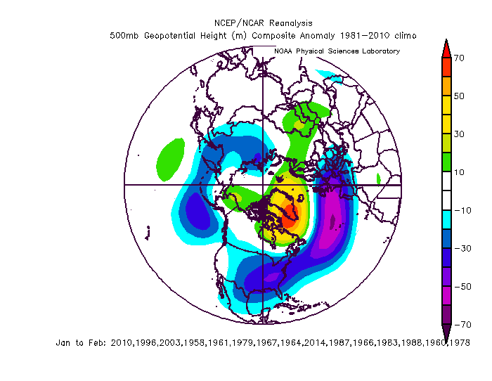
I’m not sure what you mean. We need suppressed. Just not too much. But frankly the difference between a DC or a VA/NC border snowstorm is too subtle to show up on a 7 day h5 hemisphere view mean. I could show you a 7 day mean from a DC snow period and a Richmond to Raleigh one and you probably couldn’t tell the difference. That’s just a chance we have to take. Let me post the mean of DCs 15 snowiest winters one more time to compare. this is a 5 day mean from the EPS centered day 10-15
-
No everything still looks on track. And everything is progressing on the timeline as expected. If anything the progression is ahead of schedule. Imo the issue is people are impatient and because blocking is setting in within the next 48 hours we can now see the first couple waves within a reasonable lead on guidance. But we’re still at the inception of this blocking pattern and some because it’s been so long since they had snow are already treating each model run like we’re 48 hours before a big storm and living and dying emotionally on every little turn. It’s way too soon for that. A high probability discreet threat hasn’t come in range yet. Perhaps Jan 12 becomes that. If it does I bet we see signs in the next 48 hours as it breaches the 150 lead. That seems to be the magic spot where guidance starts to hone in on synoptic level generalities lately. But getting tore up over changes on 180 hour progs isn’t productive. Other then looking at the Friday system and seeing if that changes at all I am still just peeking at the ensembles each run to see how the longwave pattern is progressing. Everything after Friday is still out of range for the emotional turmoil people are putting themselves through.
-
It’s obvious you don’t look at the guidance and are responding to what you read from weenies online. There was maybe a 24 hour period back before Xmas where the euro and GFS (CMC never bought it) head faked a faster progression to a -NAO. But other then that one day NWP always pegged a flip to a -NAO as being around Jan 5 and a flip to a colder and more snow friendly regime AFTER January 10-15. People are just impatient and jumping on every long shot wild fantasy possibility before then. The guidance NEVER indicated a snowstorm in the last 2 weeks. There was a random run or two where one outlier operational run showed some snow and weenies jumped on it. But that is NOT a guidance failure. A true snowstorm signal is when a majority of guidance across multiple consecutive runs shows it. Like right now...the UKMET shows snow Friday. But every other run misses. The guidance is NOT predicting snow. It’s predicting a miss. But some weenie will post that one UK run snow map and then you will proclaim guidance was wrong. Guidance wasn’t wrong...you simply don’t know how to use it properly. Now I will be awaiting your post telling me how you weren’t talking to me and I shouldn’t respond to you because your wisdom is above reproach.
-
Plus that cold push is ok so long as the blocking relaxes slowly (odds favor that given the current pattern). It’s as the blocking pattern relaxes but a cold antecedent airmass is left in place that our BEST windows come.
-
Week 1 might be a bit too much blocking... but week 2 everything is exactly where we want imo. And it’s typical we score as blocking relaxes not as it peaks. If we can’t score with that look...
-
Does this remind you of something
-
Everyone complaining about no cold recently gonna be crying about too much soon watch...
-
All the cutters on guidance a few days ago never made sense. If we fail in this pattern suppression is way way way more likely the reason why.
-
There is sort of a “critical mass” of snow necessary to sustain snowcover through a “normal” temperature day around here. The amount necessary to withstand some melt and compaction then freeze solid the next night. It depends on the moisture content of the snow also. I’ve noted that critical mass is about ~6” if it’s a dryer snow and ~4” if it’s a wet snow. Both those events although not that cold were very low moisture here with high ratios due to perfect snow growth. I had about 3.5” and 4.5” but neither was enough to withstand the next days melt. But it was very close...bereft melted each time with shady patches left and I bet if you added 1-2” to each event I would have kept snowcover all that week. You know on second thought that year totally underperformed and was overrated. @Ji is right!!! Wanna play hand grenades?
-
Good. I still feel optimistic about where this is heading and think our chances increase the further into this pattern we go. Perhaps peaking around the 20th depending on whether the blocking breaks or recycles. But unlike some I totally get @Ji. I feel what he says in my tormented unfiltered inner weenie soul. I just try to get a grip and apply a logic filter before posting. Most of the time! But it’s frustrating when we’ve had so little snow lately to have to wait. But I do think this would require a pretty monumental epic fail not to get at least one hit from this pattern.
-
It does not look like this SSW will help us wrt arctic cold. That seems directed to Asia. But it likely will favor continued weakness on the TPV and that should help is wrt blocking. We will just have to make due with domestic cold, same as 2010. I wonder if people realize how mild we would have been straight through that whole snowmageddon period had the storms not hit. We had one decent transient shot of cold in late Jan but after that we would have had highs near 50 had those storms not hit. Even up here all the snow from the Jan 30 and Feb 2 storms melted by the time Feb 6 happened. And even with 50” of snow otg highs were near 40 up here immediately after those 2 HECS. It was not a cold pattern at all. Would have been avg temps if not for the snowcover. Maybe even above avg.
-
That’s because the only time we ever pay attention to it (mostly because of its lack of easy access) is when the other guidance isn’t showing what we want and it is. And none of the guidance typically performs well when it’s on its own...even the euro. Even the euro isn’t so much superior that it should be given preference if it’s an outlier amongst all guidance. Any model that shows a vastly different prog then the consensus is “likely” wrong. Every once in a while the outlier is onto something and scores a coup. Every model has had its example of that. But it’s not a good bet.
-
@frd there is bickering amongst the strat peeps wrt the significance of that long term. I think this flux failure itself doesn’t have any since the SSW is underway without it. But I see some posts that make sense that if future heat fluxes fail we might not get the subsequent SPV weaknesses that portent better propagation into the Trop. That could mean less impact into Feb.
-
The failure there is likely related to the suddenly less hostile look this week to the point a storm Friday that was supposed to be a cutter might get suppressed south of us. Last week I was pointing out the NE ridge was originating from a heat flux in the tropical pac. When that died suddenly the ridge in the east went away.
-
The waves have been slowing down in general which is common in blocking regimes on guidance. Perhaps at this point a much slower progression is our best bet to get the flow to relax enough to our northeast.
-
There are multiple factors (like the kicker and the NS SW) but the biggest issue is over the last 36 hours guidance has consistently been weakening the upper low which allows it to get squashed further and further south
-
Depends...did we gain any western outliers? Goalpost tightening will happen as you get closer but if you’re outside the goalposts that won’t help.
-
@Ji check out the lengths it had to go to avoid showing blue here!!! 988 off the coast, 534 thickness on Jan 16 and....snow nazi say no blue for you...you come back 6 hour
-
I feel like I need another shower after watching that game.
-
The gfs has been a wreck BUT the reason it cuts there is that it was so anemic with the system on the 9th that it fails to deepen enough of a 50/50 feature and a lot of ridging pops over the northeast. If that happens something could cut. Remember it’s as much the 50/50 that prevents that as the -NAO. However, guidance was doing that for this week 5 days ago and now we might see a storm suppressed to our south! It’s probably BS but the physics on the model aren’t junk. It won’t show something that is technically a physical impossibility. It might go off on a tangent and depict a faulty pattern evolution due to biases or misrepresentation of a feature though.
-
HM thinks this first storm gets suppressed but still bullish after


