

psuhoffman
-
Posts
26,289 -
Joined
-
Last visited
Content Type
Profiles
Blogs
Forums
American Weather
Media Demo
Store
Gallery
Everything posted by psuhoffman
-
I think the ridge axis (too far west) out west is a bigger issue. As I argued last night the NAO may not be a picture perfect Davis strait Rex block there...but it’s not supposed to be that hard to get snow. We don’t live in the tropics. A regular old Greenland -NAO ridge has resulted in snow here plenty. Maybe not a 20” HECS but a snowstorm. You can nitpick a minor flaw in almost any pattern. But there is way more right then wrong there. Yet lately is seems unless everything is 100% perfect in every way we can’t buy a snowstorm near DC. ETA: I said near DC because DCA is a joke. It doesn’t surprise me if a runway on an island south of DC at sea level lower in elevation then everyone around them can’t get snow. But even places around DC that average 20” a year can’t seem to buy any snow lately.
-
Gotcha lol
-
What Pac tele are you referring too? We’ve had a +PNA since late Nov and the EPO has no correlation to snowfall here.
-
Me either. I debated not even bringing it up but I’m not a head in the sand kind of guy. That option is there. My guess is that their progressing the pattern too quickly. We also haven’t seen any impact from the SSW yet. Lastly we’ve seen blocking regimes head fake a break down on guidance many times before.
-
Imo it doesn’t matter once we get to March anyways. The shorter wavelengths have made March a wildcard in a Nina. There doesn’t seem to be any correlation with some Nina years ending cold/snowy and some a torch with no regard to the strength of the Nina into late winter. Nina forcing is bad so it’s not gonna hurt to see it weaken but we’re at the point where it’s becoming irrelevant because by the time the lag wears off the part of the season where Nina has much impact has ended.
-
That isn’t actually a good look. That’s the first wave (of what was supposed to be a more extended period) but that isn’t going to produce a snowstorm here. 1. That trough doesn’t have enough depth. 2 look at the ridging in front of it. 3. The antecedent airmass sucks. The cold is behind the wave. so...ridge in front, crap airmass, no depth...any storm with that trough is going north of us. If you look at the individual members you will see what I mean. It would be the next wave that has potential. But the problem is there is no next wave on that EPS run. It retrogrades the pattern too quickly such that nothing can amplify east and knock down the WAR and becoming a 50/50. Instead the trough axis pulls into the west and everything would cut then wash out. The next wave (the one I identified on the GEFS last night as a good threat window) never makes it into the east. It’s only one run. I’m not jumping on this. I was just pointing out that it’s there. The EPS paints a fail picture. I’m not ready to jump ship because of one bad run though.
-
I’m not going to analyze it or freak out but I’ll just put it out there. The 0z EPS is an unmitigated disaster. It lost the poleward EPO ridge and develops a flat central pac ridge which directs the pac firehouse jet right into the US. There isn’t even any transition because that happens so fast the pattern is wrecked before the next flux of the NAO can even do us any good. It’s just one run. GEFS at 6z still looks good. Just hope it’s wrong. It shows exactly what I said my fear was if the N PAC pattern relaxed.
-
Considering our source region there is the North Pole I would hope so. If we can’t get any cold in that pattern it’s time to pack it in.
-
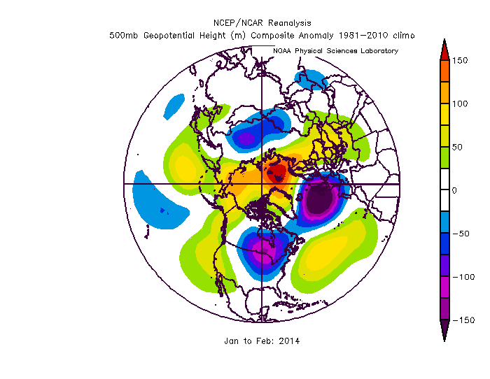
2014 not a horrible match except again featured displaced south due to the -NAO
-
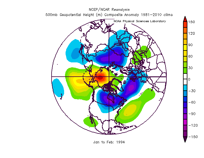
1994 has been showing in the week 2 analogs a lot. Interesting. I can see the similarities but this year has more NAO blocking and everything is displaced south because of it on the long range guidance. Get a 1994 type pattern but shift it south 100 miles and we would be pretty happy.
-
If this 10 day mean January 15-25 can’t produce something...I don’t know what to say
-
A discreet threat window might be coming into focus. This setup is hinted at on the CMC GEFS and EPS. Around Jan 18-20 The -NAO is centered and oriented in a much better location (across all guidance) there compared to this first iteration (below). The orientation there (especially how it extends back into Quebec and Ontario is too suppressive. That’s going to shift the storm track pretty far SE but it’s also completely cutting off any cold (even domestic cold) from Canada. But the look above day 9 is where we want a block centered. That prevents excess ridging in the east but allows enough room for a wave to amplify. It also allows cold intrusion into the US from western Canada. We likely have a colder antecedent airmass to work with. Clear 50/50 signature but with a decent spacing between waves and a sharp ridge (we want sharper not shallow with those wavelengths and blocking) far enough west to allow that wave to dig in to out west. Provided that wave can have enough depth/amplitude such that the southern branch gets involved and it can track under us that would be a good setup. The parts are all there. Imo the first really truly good look at a discreet period/threat. But it’s still on the far edge of where we can see any details with clarify. I will be interested in how this time period evolves the next few days.
-
That should have had a much better precip representation but it will look completely different in 6 hours anyways
-
Arrival of cold still looks on pace for around the 15th
-
Generally yes. Fast dominant NS will increase the chances. But that’s kind of the status quo. The mean NS position will be just to our north in winter and so that places the most likely path of those NS SWs through the lakes. We complain about bad luck but it’s really just normal. Getting a high blocked in to our north is the unusual thing. That’s why snow isn’t normal here. We’re too far south to typically get much from those NS polar boundary waves and getting the pattern we need to make a southern stream system work isn’t that common either.
-
It’s not a Rex block but it is an omega block or NAO ridge. A Rex block is better. The rare white elk pattern. So I’m not saying the details you just posted are wrong. But the way you say it kind of implies we need a Rex block to snow. We’ve had plenty of big snowstorms with a regular old -NAO and not a full on Rex block. I am as frustrated as everyone but I keep seeing these posts blaming very minor imperfections in an overall very good longwave pattern as if the pattern is all wrong. We would almost never get snow if we needed all these variables to be absolutely perfect like some imply. And I know lately it has been that way but I’d like to hope that’s just bad luck and not a new normal because if the only way we can snow is if we have a full on Rex block located exactly over the Davis strait with a +PNA and a -EPO and cross polar flow and a displaced TPV we will get one snowstorm a decade if we’re lucky.
-
-
@Ji I like you. I know you didn’t mean that in a malicious way. It was an attempt at humor gone wrong. But you should delete that. There is probably someone in here who has lost a loved one and that can cause unnecessary trauma at a place people come to escape it.
-
Yea that isn’t bad. Storms would “try” to cut but so long as there is antecedent cold good luck with that blocking look to our northeast. That could lead to miller b hybrids that transfer pretty far south (again with the stipulation there is cold in front).
-
The great gravy famine has to END
-
Who doesn't want gravy. Toss those unamerican losers on an island somewhere NOW
-
@CAPE @frd Sorry I didn't respond earlier today I have been very busy. But wanted to comment on your posts early this morning regarding the pattern in general. CAPE your point about where we have been and going is 100% accurate so this is not meant to be confrontational...in the current pattern we have NOT been able to develop enough domestic cold under the pacific flow into Canada for it to work out. We have had SW after SW track under us with nothing to show. But here is where I want to point out something...Posting the map CAPE showed earlier That pattern you are totally correct has NOT worked....but it is responsible for the vast majority of our MECS and HECS snowstorms. That look (+PNA,-NAO, Aleutian low, split flow) is the holy grail! Yes the Aleutian low pumps pac maritime air across Canada...but historically we have been ok with cold that develops UNDER the split flow. Its NOT a cold look. But a huge percentage of our snow came during that pattern when frankly had there not been a storm it would have been 50 degrees in DC that day. A LOT of our big snowstorms historically came with temps right near 32 degrees even with a saturated boundary layer. SO I am not disputing that this has not been working out for us lately...but I am also not willing to just throw that look away as not a good snow pattern because frankly if that no longer works...DC would average like 6" of snow and I am not exaggerating. Without all the snow we get from that split flow pattern there...DC's snow climo would be the same as TN or NC where they have to wait for some blue moon perfect storm of variables to come together ever few years to get snow. So lets hope this lack of success is bad luck and due to the really awful early season pattern and all the cold becoming locked on the other side of the globe. Because that pattern HAS to work...it is our best snow pattern and trust me no one will be happy with what our snow climo would look like if that no longer works. But...moving on where is this heading...I am using last nights run that CAPE posted because I have been too busy to really dig into todays stuff yet. Yes this is colder...but its also not going to produce a significant snowstorm. Look at where the flow is...waves are going to be coming in way too far north and east into the CONUS in that pattern to do us much good. That wave 1 full latitude ridge west trough east look is just a cold/dry look. But luckily its temporary and we head towards this look after... This has more potential. But let me point out...where that EPO ridge is located is way too far west to do us any good if it wasn't for the -NAO and the displaced TPV in southeast Canada. There is only 2 ways to really get snow here from an EPO driven pattern. Luckily one is that right there...to get a displaced TPV in southeast Canada. The other is to have a very rare positively tilted EPO ridge that extends into the Yukon. That was how 2014 worked at times. But both of those are extremely rare. We have had several EPO patterns in the last 5 years that did not produce any significant snowfall for Baltimore/DC. That is way more common. So that goes back to my point above...we really don't want to have to rely on getting all the little details needed that rarely happen to make an EPO pattern our best snowfall one. It might work here because we also have a -NAO and favorable TPV location...but the EPO will never be a reliable index for snowfall because it requires other rare variables for it to be helpful. Otherwise it dumps the cold into the west and yes that bleeds east behind storms but then retreats anytime a wave amplifies because the trough axis it too far to our west. That look above though...the NAO/displaced TPV will resist a SE ridge and force that cold to turn east under the blocking and set up a gradient for storms to ride. The danger though is if storms do not dig far enough south it just becomes a cold dry pattern. Longer term the dangers is if the NAO/AO back off too much the gradient will end up to our NW. But that right there is a good look and promising. But in the broader since I am not willing to just throw out a pattern (split flow -NAO) that accounts for like 75% of our snowfall! Lets hope that isn't necessary and this year is just more bad luck then anything else.
-
That’s common in a blocking pattern. We don’t need every SW to amplify just one or two. Could it just be cold/dry...yes that’s happened before. Or one wave amplifies and we get a big snow.
-
Move to Boone


