psuhoffman
-
Posts
26,289 -
Joined
-
Last visited
Content Type
Profiles
Blogs
Forums
American Weather
Media Demo
Store
Gallery
Everything posted by psuhoffman
-

Feb Long Range Discussion (Day 3 and beyond) - MERGED
psuhoffman replied to WinterWxLuvr's topic in Mid Atlantic
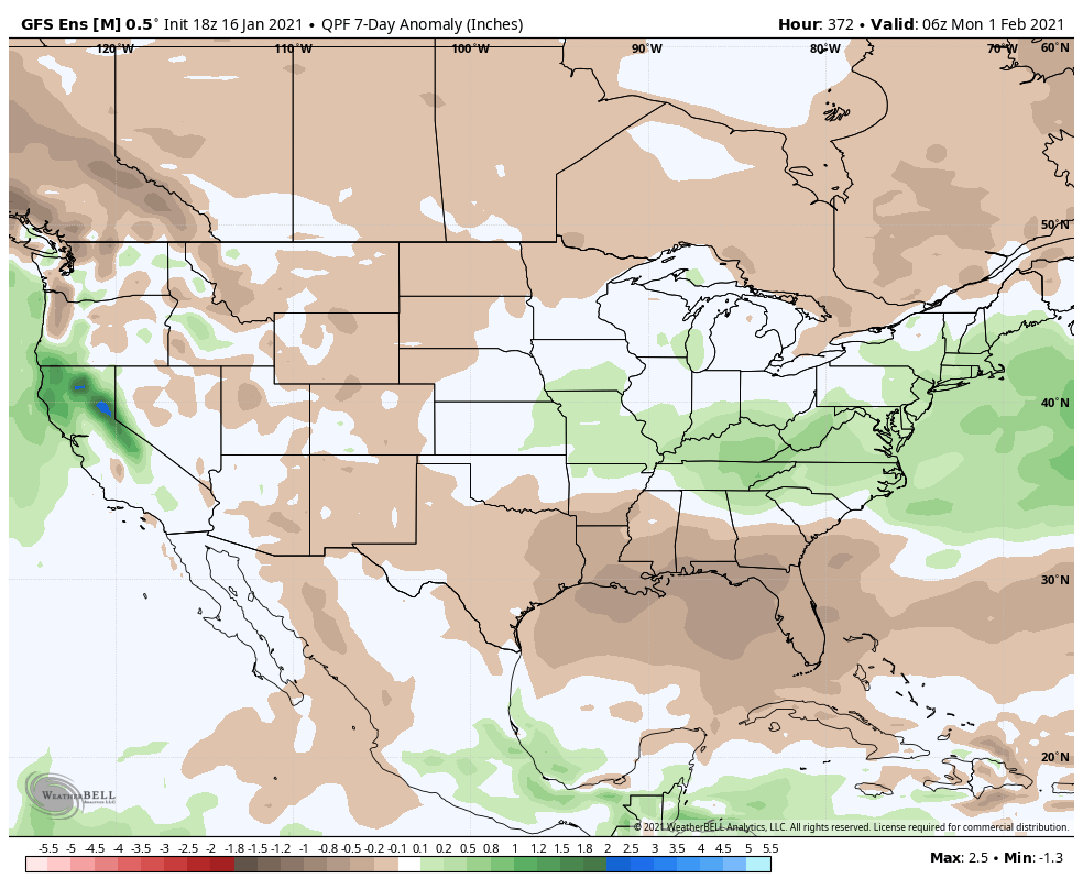
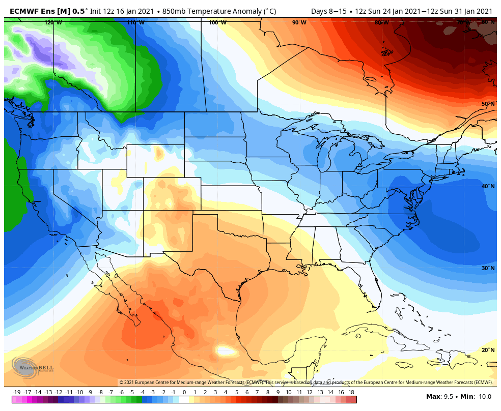
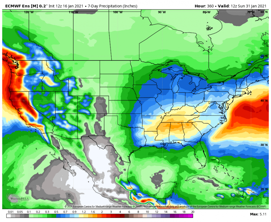
@WxUSAF @CAPE @frd how unlucky can we be with this look lol. 7 day 850 temp anomaly 7 day precip anomaly Same pattern on eps If this doesn’t work I’m out of ideas
-
Feb Long Range Discussion (Day 3 and beyond) - MERGED
psuhoffman replied to WinterWxLuvr's topic in Mid Atlantic
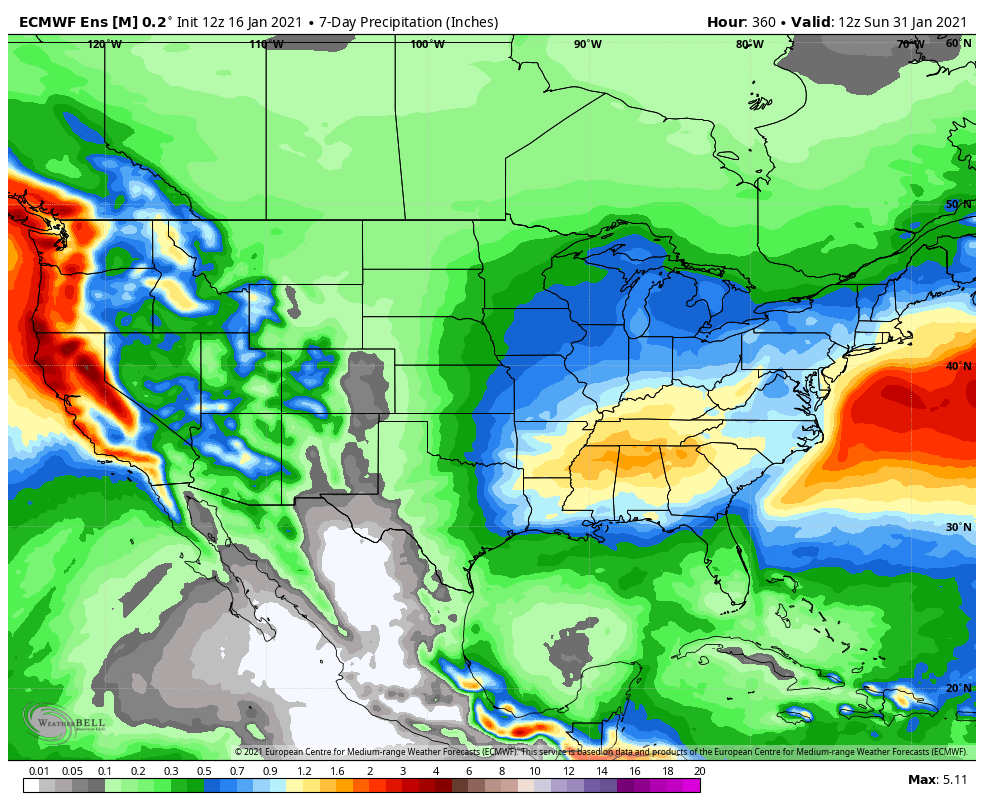
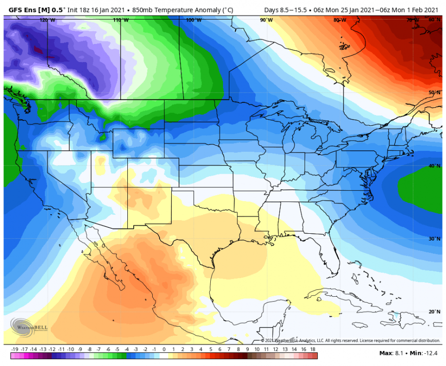
Let’s just simplify this... I’ll take this 7 day precip with these 7 day temps please and thank you.
-
Feb Long Range Discussion (Day 3 and beyond) - MERGED
psuhoffman replied to WinterWxLuvr's topic in Mid Atlantic
Thanks for making me feel REALLY old -
Feb Long Range Discussion (Day 3 and beyond) - MERGED
psuhoffman replied to WinterWxLuvr's topic in Mid Atlantic
It can’t decide what to do with the NS. Yesterday it was diving in front and squashing. 12z it phased and cut. This run it slides across on top. That runs some interference but it’s still a pathetic thermal presentation for late January and no pac puke excuse this time. -
Feb Long Range Discussion (Day 3 and beyond) - MERGED
psuhoffman replied to WinterWxLuvr's topic in Mid Atlantic
Anyone noticed they used the F scale not C. And the color scale has every half degree. So it’s a general 2 degree F difference over a 7 day period a week away. That’s not unusual variance run to run. Their presentation skews the perception imo. -
Feb Long Range Discussion (Day 3 and beyond) - MERGED
psuhoffman replied to WinterWxLuvr's topic in Mid Atlantic
DC averages 5.7” the whole month of January. And all that 5” mean is from a 6 day period. DCs highest avg weekly snowfall is probably about 1.5”. -
Feb Long Range Discussion (Day 3 and beyond) - MERGED
psuhoffman replied to WinterWxLuvr's topic in Mid Atlantic
Exactly but it’s been so long people probably forget how it works. A couple of those 2010 storms had primaries get pretty far NW also... -
Feb Long Range Discussion (Day 3 and beyond) - MERGED
psuhoffman replied to WinterWxLuvr's topic in Mid Atlantic
I must have missed when we asked for a wet blanket today. -
Feb Long Range Discussion (Day 3 and beyond) - MERGED
psuhoffman replied to WinterWxLuvr's topic in Mid Atlantic
1. The low moves up west of the apps then transfers to eastern NC 2. there is a banana high over the top 3. read my post about the dry air -
Feb Long Range Discussion (Day 3 and beyond) - MERGED
psuhoffman replied to WinterWxLuvr's topic in Mid Atlantic
It’s way too soon to be worried about this...but wanted to point something out that can be useful when we are closer to an event. There are lots of variables but one factor that helped us survive a primary track to our west was this. As the system approaches this looks precarious at a glance. The mid level boundary isn’t that far to our SW. But look at the 850 temps to our south and southwest. 1-2 c mostly. Now look at the humidity. that whole area is bone dry. All that air will advect north ahead of the low. As it saturates and lifts north it will be plenty cold enough. The actual boundary of air that wouldn’t support snow that would have to advect north is much further south. -
Feb Long Range Discussion (Day 3 and beyond) - MERGED
psuhoffman replied to WinterWxLuvr's topic in Mid Atlantic
There is a lot of dry air that will cool as it saturates to our south (will advect north ahead of the low). We should be ok for at least a thump. -
This next cold shot is different because the epo finally goes negative and injects some arctic air. Guidance continually tried to cool the N American profile at range and in defense that’s what historically SHOULD happen this time of year. Additionally even when the pattern in the pacific reverses and the coldest air shifts to N Amer it’s pathetic. Frankly the only place that seems to sustain truly arctic cold air masses lately regardless of the pattern is Siberia.
-
I agree that’s greedy but I didn’t set the premise or the ratios @Ji did. A 50” winter for me is actually less above normal then a 20” winter is in DC! A 20” DC winter is equivalent to a 57” winter here. ETA: but if we aren’t going to adjust for local climo then I’m a hard no. In the last 20 years only 3 were worse then 20” so I’d take my chances lol
-
Feb Long Range Discussion (Day 3 and beyond) - MERGED
psuhoffman replied to WinterWxLuvr's topic in Mid Atlantic
Cmc ensembles target central VA for the day 9 threat. -
Feb Long Range Discussion (Day 3 and beyond) - MERGED
psuhoffman replied to WinterWxLuvr's topic in Mid Atlantic
I thought we stopped with the storm name thing. Besides I’m sure some high school kid from Delaware on Twitter called it back in June. -
Feb Long Range Discussion (Day 3 and beyond) - MERGED
psuhoffman replied to WinterWxLuvr's topic in Mid Atlantic
Makes total sense now -
Feb Long Range Discussion (Day 3 and beyond) - MERGED
psuhoffman replied to WinterWxLuvr's topic in Mid Atlantic
The mean to our north is skewed high by a camp of members that really bomb the storm and crush just to our northeast. Kind of a miller b evolution but a hybrid not a total screw job here. But there is a camp that’s still somewhat suppressed and targets just to our south. That’s not a bad spot to be at this range. -
Feb Long Range Discussion (Day 3 and beyond) - MERGED
psuhoffman replied to WinterWxLuvr's topic in Mid Atlantic
Something is definitely broken -
Feb Long Range Discussion (Day 3 and beyond) - MERGED
psuhoffman replied to WinterWxLuvr's topic in Mid Atlantic
The block retrogrades a bit too far west this run which allows the 50/50 to escape and too much ridging. That’s part of why the storm gains so much latitude before the jump. Ggem looks similar at the surface but for a completely different reason. The blocking stays further east but links up with the mid latitude ridge which causes a cutter. Both still get us some frozen despite a west track. The big takeaway is the American globals finally picked up on a healthy wave ejecting there. -
Feb Long Range Discussion (Day 3 and beyond) - MERGED
psuhoffman replied to WinterWxLuvr's topic in Mid Atlantic
This run the NS wave (1) came in behind the southern wave (2) and phased. Want this to become a monster for us just need that NS to dig a bit more. Once they phase the upper feature tracks east under the block but that happens just north of our latitude. -
Feb Long Range Discussion (Day 3 and beyond) - MERGED
psuhoffman replied to WinterWxLuvr's topic in Mid Atlantic
6z gfs wasn’t that bad. Speed the NS up or slow it down and it was close to a better solution. This NS wave(1) which keeps changing every run suppressed the flow in front. Get it out of the way and the next one (3) can dig in. Slow it and get it behind the southern wave (2) and it would phase. Just need that to adjust. It actually ejected a healthy wave that run. -
Feb Long Range Discussion (Day 3 and beyond) - MERGED
psuhoffman replied to WinterWxLuvr's topic in Mid Atlantic
It’s been positive and that did us no good...a -pna can work if other factors line up. There are also signs the ridge will retrograde into the SW eventually. -
Feb Long Range Discussion (Day 3 and beyond) - MERGED
psuhoffman replied to WinterWxLuvr's topic in Mid Atlantic
The first flex of the NAO failed. That’s over and done. We had a great -NAO but there was no cold in the pattern. We wasted it. So all those calls were wrong. Now we’re tracking the next round of blocking. There looks to be more cold this time. Or would you prefer we just pack it in and go home because the last one failed? -
Feb Long Range Discussion (Day 3 and beyond) - MERGED
psuhoffman replied to WinterWxLuvr's topic in Mid Atlantic
I still think the waves the 24-30 have potential. But it’s also true we do better as blocking relaxes and we may be anxious and so jumping the gun. We might need to wait for the flow to relax. -
Feb Long Range Discussion (Day 3 and beyond) - MERGED
psuhoffman replied to WinterWxLuvr's topic in Mid Atlantic
Cmc ensemble doesn’t agree with suppressed either. Actually more rain then suppressed members.