psuhoffman
-
Posts
26,289 -
Joined
-
Last visited
Content Type
Profiles
Blogs
Forums
American Weather
Media Demo
Store
Gallery
Everything posted by psuhoffman
-

Feb Long Range Discussion (Day 3 and beyond) - MERGED
psuhoffman replied to WinterWxLuvr's topic in Mid Atlantic
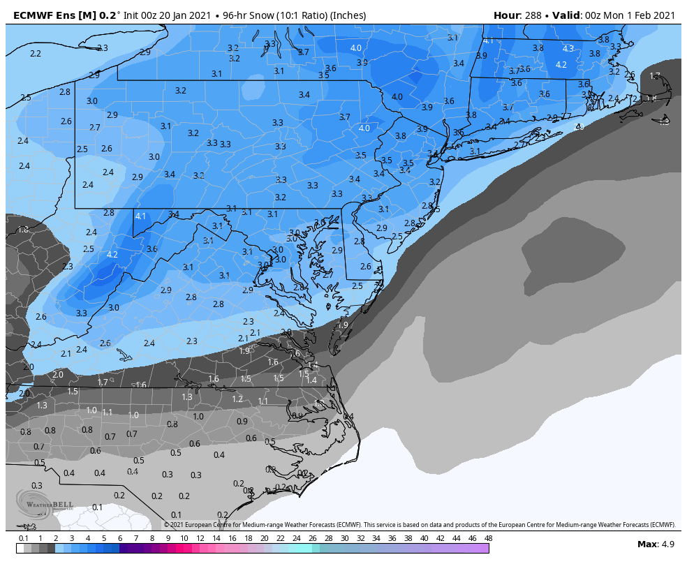
EPS still likes the 28th/29th ETA: so it’s debatable whether this is capturing 2 different events over these 4 days or if it’s one event with timing differences. There aren’t any members with two hits. But members that eject a wave around the 28 that’s it. Other members wash that out and develop the next wave instead a day later. But bottom line is eps really like something between the 28-31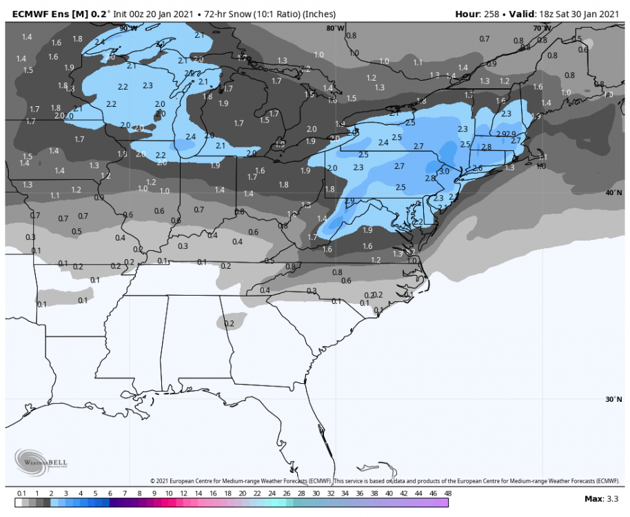
-
January Storm Term Threat Discussions (Day 3 - Day 7)
psuhoffman replied to WxUSAF's topic in Mid Atlantic
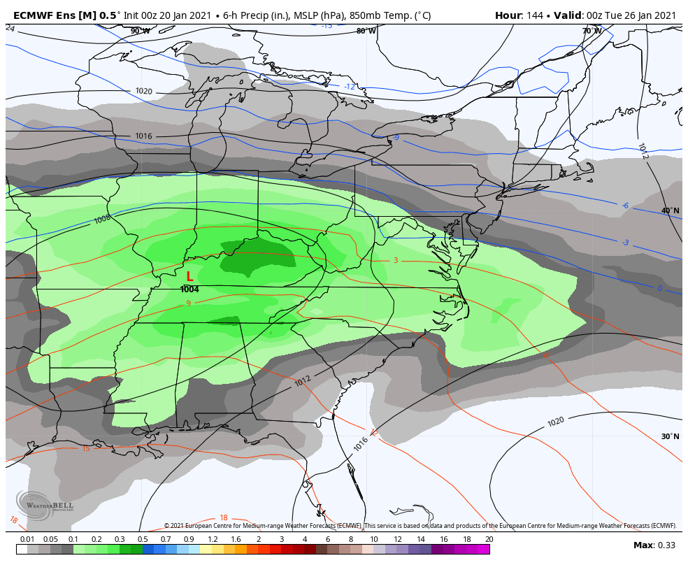
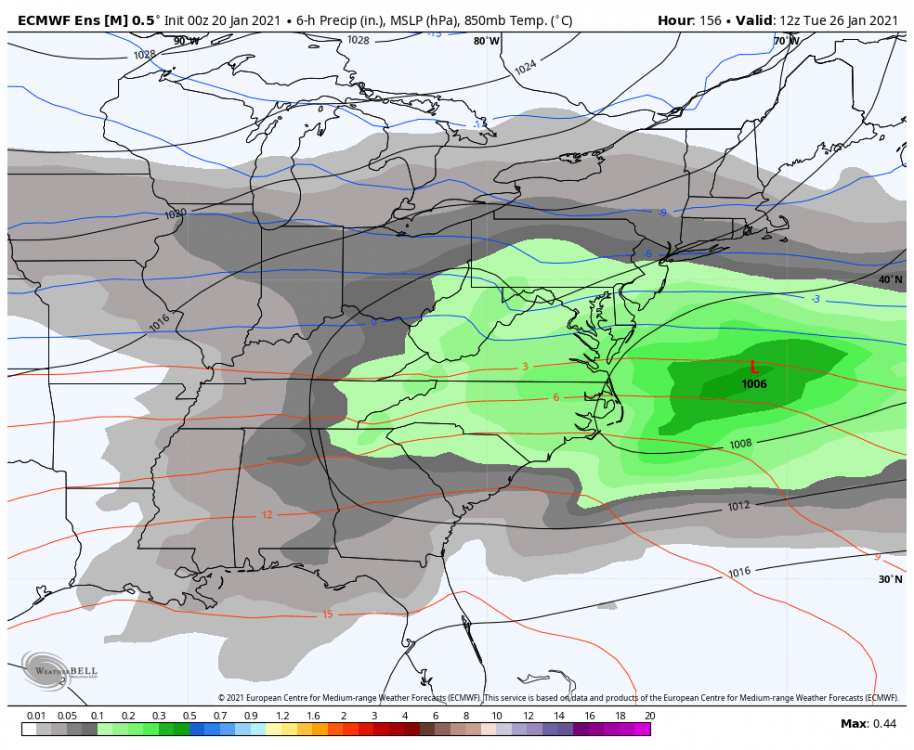
This captures the whole event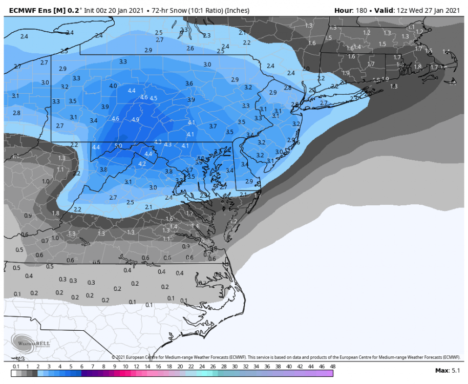
-
January Storm Term Threat Discussions (Day 3 - Day 7)
psuhoffman replied to WxUSAF's topic in Mid Atlantic
Straight filth -
January Storm Term Threat Discussions (Day 3 - Day 7)
psuhoffman replied to WxUSAF's topic in Mid Atlantic

-
January Storm Term Threat Discussions (Day 3 - Day 7)
psuhoffman replied to WxUSAF's topic in Mid Atlantic
The setup has some similarities. That was a nino so a healthier STJ. This will hit a brick wall similar to how that one did. Similar blocking. -
January Storm Term Threat Discussions (Day 3 - Day 7)
psuhoffman replied to WxUSAF's topic in Mid Atlantic
But is snowed a couple hours longer. -
January Storm Term Threat Discussions (Day 3 - Day 7)
psuhoffman replied to WxUSAF's topic in Mid Atlantic
That block is legit. If the NS doesn’t phase with the TPV like the gfs...this won’t gain much latitude imo. But there is always room for a 30 mile tweak that gets the death band to Carroll county lol. -
January Storm Term Threat Discussions (Day 3 - Day 7)
psuhoffman replied to WxUSAF's topic in Mid Atlantic
Perfect run for DC. Flush hit. -
January Storm Term Threat Discussions (Day 3 - Day 7)
psuhoffman replied to WxUSAF's topic in Mid Atlantic
Euro still handling the tpv interaction different from gfs, hopefully same result as cmc & previous run Gfs euro -
Feb Long Range Discussion (Day 3 and beyond) - MERGED
psuhoffman replied to WinterWxLuvr's topic in Mid Atlantic
@Ji the 28th threat definitely not dead on the geps. Quite a few members with a storm there. I count 12/20. -
January Storm Term Threat Discussions (Day 3 - Day 7)
psuhoffman replied to WxUSAF's topic in Mid Atlantic
Simply guidance tonight trended towards a much weaker wave ejecting out west. The ridge out west was actually better on the gfs. No real change in the longwave pattern. The setup is still there. But what had been a very healthy wave being ejected from the western trough suddenly went poof tonight. ETA: there are a handful of members in the gefs that still have it. Let’s see what the eps does before declaring it dead. -
January Storm Term Threat Discussions (Day 3 - Day 7)
psuhoffman replied to WxUSAF's topic in Mid Atlantic
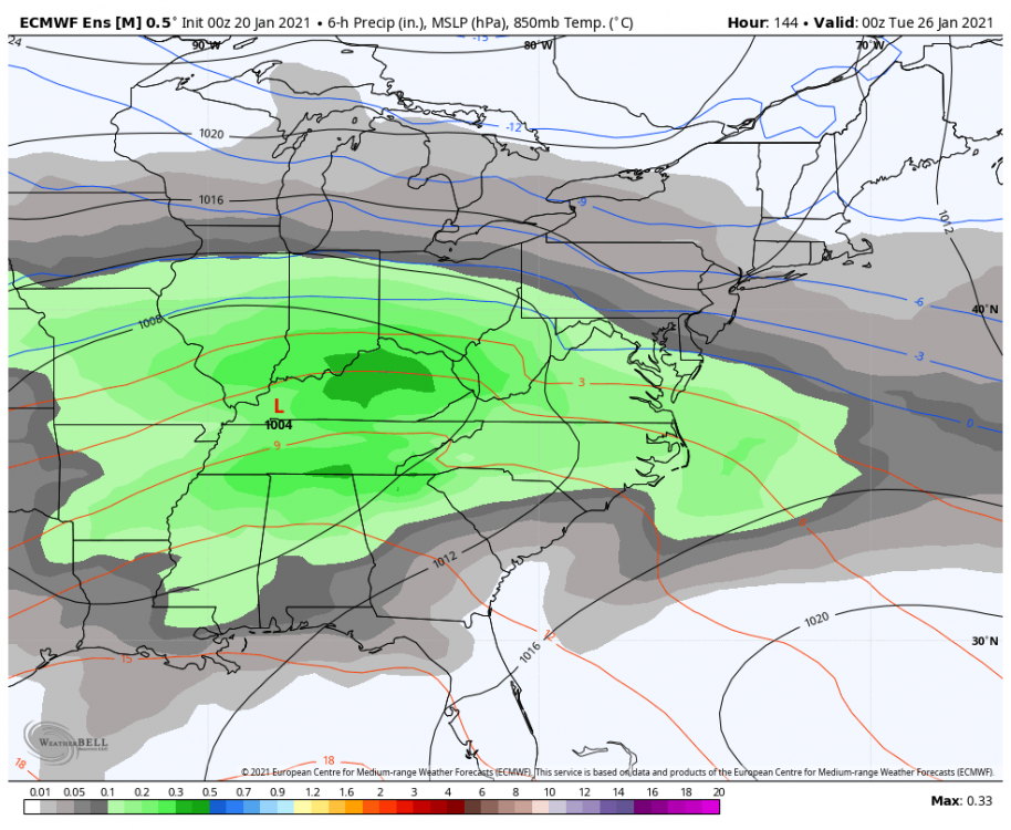
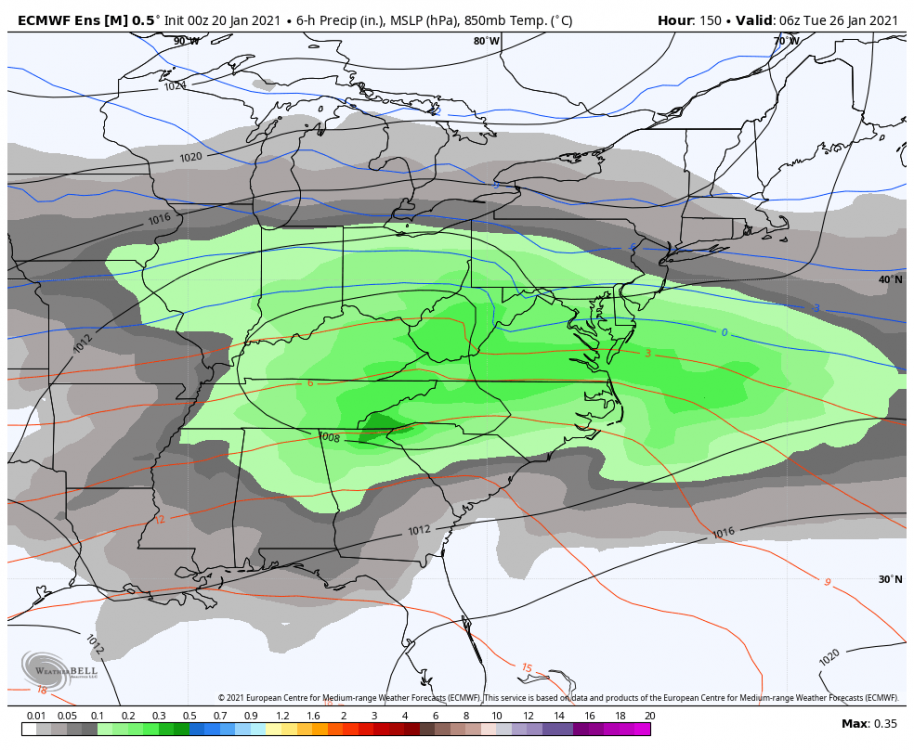
The cmc/euro and gfs are night and day how they handle the interaction between the western trough and the tpv between 100-120 hours. I wanted to show it clearer but the h5 plots for Canada weren’t updated yet for the cmc but you can see it here...by 120 it’s a done deal cmc/euro v gfs/Icon progression. cmc at 120 the tpv elongated on top of the western trough and did not phase. It’s instead suppressing the northern stream wave (NSW) lol. gfs same time the tpv had phased with the NS wave and look at that ridging east of it. It’s game over already at that point the divergence after is the result of that singular difference which actually happens around 100 hours up in Canada but those maps weren’t out yet. by 144 you can see the end result cmc the tpv elongated and broke a piece off that came across on top and crushed the NS wave. The SSW was left to amplify and you see the ridging in front to combat the shred factory on top from the blocking. gfs at 144 the phased NS system came across on top end wrecked our temps but also the flow under that is squashing the SSW. No chance in that progression. cmc and euro are both handling that the same way. Just trying to point out the why behind it. Hope someone finds this interesting. -
January Storm Term Threat Discussions (Day 3 - Day 7)
psuhoffman replied to WxUSAF's topic in Mid Atlantic
Welcome to 2021 -
January Storm Term Threat Discussions (Day 3 - Day 7)
psuhoffman replied to WxUSAF's topic in Mid Atlantic
Lol I haven’t even started to analyze it. While Ji moves from precip plot to precip plot looking for blue I’m OCD analyzing all the different levels and details to see why exactly the run did what it did. Haven’t even got to the cmc yet. -
January Storm Term Threat Discussions (Day 3 - Day 7)
psuhoffman replied to WxUSAF's topic in Mid Atlantic
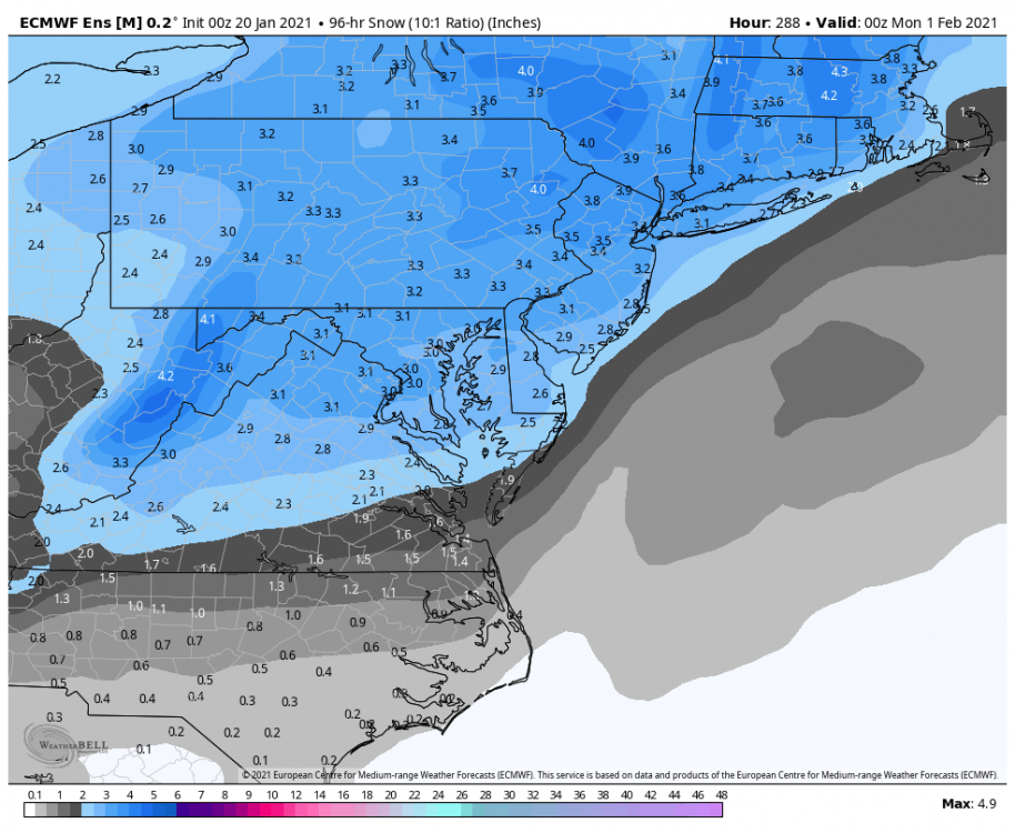
It’s 150 out. That’s fine. You know details will shift slightly even inside 48 hours let alone 150. But again shame in this setup look at that rather pathetic scope of snowfall. It makes it harder to get a hit when the margin of error is so small. -
January Storm Term Threat Discussions (Day 3 - Day 7)
psuhoffman replied to WxUSAF's topic in Mid Atlantic
Big if here...but if the euro cmc have the right idea with not phasing the tpv out west and crushing the NS front runner...then suppression is by far the bigger threat for places north of DC from the southern wave. That block is legit. The NS wave only cuts because it phases with a piece of that tpv. If it misses that boat it’s getting crushed and that southern wave will struggle to gain much latitude in this flow. -
January Storm Term Threat Discussions (Day 3 - Day 7)
psuhoffman replied to WxUSAF's topic in Mid Atlantic
You aren’t going to like this but I’m not sure the gfs is going to cave. I still won’t bet against the euro when it’s rock steady over several days like this...and has the cmc on its side. But something keeps nagging me in the back of my mind. The way the gfs handles that western TPV is simpler. Less convoluted. Simply merges it with the strong NS wave diving into it. The euro on the other hand does this weird elongation and split to avoid that and instead through that odd progression ends up suppressing and squashing the NS SW. But 2 things bug me. 1 we are in a northern stream dominant regime. 2 the gfs progression is simpler and simple usually wins v convoluted. So yea the better guidance is on our side. But Nina climo, recent trends, and history of simple v convoluted setups are on the other side. -
January Storm Term Threat Discussions (Day 3 - Day 7)
psuhoffman replied to WxUSAF's topic in Mid Atlantic
See that feature in Quebec on the euro. That was the piece of the tpv that came across in front and squashed the northern wave. On the gfs that instead phases with the northern wave. After that it’s a done deal both ways. -
January Storm Term Threat Discussions (Day 3 - Day 7)
psuhoffman replied to WxUSAF's topic in Mid Atlantic
That’s because of the NS. Gfs still dropping too much energy from the TPV in western Canada into the western trough. That pumps ridging ahead of it and so the result is the NS wave on top can amplify. That becomes the show. The southern wave has no chance with an amplifying NS wave right on top and in front of it. The euro handles that tpv different. Elongates it down on top and squashed the NS wave. With that wave eliminated the southern stream wave has room to amplify. -
January Storm Term Threat Discussions (Day 3 - Day 7)
psuhoffman replied to WxUSAF's topic in Mid Atlantic
Funny thing is it did at 6/12z and everyone kinda figured the fight was over but then it reverted at 18z and now has a buddy in the Icon. -
January Storm Term Threat Discussions (Day 3 - Day 7)
psuhoffman replied to WxUSAF's topic in Mid Atlantic
@Ji it’s still about that TPV west of Hudson Bay. The GFS is elongating a piece of it and phasing a bit with the western trough which pumps ridging ahead of it. The euro is not and actually is elongating that tpv to the southeast which compresses the flow over top and prevents ridging ahead of the wave. The crazy thing is the difference in that feature diverges at only like 96 hours and it’s a pretty major longwave feature that one of them is handling completely wrong. -
January Storm Term Threat Discussions (Day 3 - Day 7)
psuhoffman replied to WxUSAF's topic in Mid Atlantic
I’m just doing play by play not picking winners -
January Storm Term Threat Discussions (Day 3 - Day 7)
psuhoffman replied to WxUSAF's topic in Mid Atlantic
Gfs is a baby step weaker with that NS wave v 18z but still WAY WAY WAY more ridge in front then the euro. -
January Storm Term Threat Discussions (Day 3 - Day 7)
psuhoffman replied to WxUSAF's topic in Mid Atlantic
We’ll know before then. If the gfs holds and cmc and UK (it will be within range tonight) joins the gfs/Icon solution we know. The euro would then be on an island and we know how that ends. If the Cmc/UK look like the euro then it’s probably the gfs and Icon on a tangent. -
January Storm Term Threat Discussions (Day 3 - Day 7)
psuhoffman replied to WxUSAF's topic in Mid Atlantic
If the NS wave holds together like the gfs/Icon show the southern wave is irrelevant. The NS wave that comes across in front of it wrecks the temps and there isn’t enough separation to recover. ETA; we would need the southern wave to slow down and allow cold to press behind the NS. Possible but we’re starting to get close enough that major changes need to happen sooner v later. The easier path here is less ridging and therefore a weaker NS wave like euro.