psuhoffman
-
Posts
26,289 -
Joined
-
Last visited
Content Type
Profiles
Blogs
Forums
American Weather
Media Demo
Store
Gallery
Everything posted by psuhoffman
-

January Storm Term Threat Discussions (Day 3 - Day 7)
psuhoffman replied to WxUSAF's topic in Mid Atlantic
If you ignored the gfs the cmc and euro were pretty consistent for several runs until today -
January Storm Term Threat Discussions (Day 3 - Day 7)
psuhoffman replied to WxUSAF's topic in Mid Atlantic
North of the CMC??? I honestly thought that cmc run was eye opening bad in how far north it was. Kinda hoped that would be an extreme outlier. -
January Storm Term Threat Discussions (Day 3 - Day 7)
psuhoffman replied to WxUSAF's topic in Mid Atlantic
How bad was the UK? Hopefully not as far north as the CMC! -
January Storm Term Threat Discussions (Day 3 - Day 7)
psuhoffman replied to WxUSAF's topic in Mid Atlantic
Better -
@leesburg 04 My points are frustration at the larger picture and how much harder it's getting to get snow...not specific to this week. We may luck out still...its a really nice setup still...just need some south adjustment to the current consensus but I am also still seeing signs the coverage of snow will be much less then it should be historically given this setup. An amplifying southern wave sliding west to east under a block with an airmass that originated in the Arctic over the top...that should have a HUGE expansive WAA snow shield to its north and northeast and we shouldn't need to be sweating getting the exact perfect track to get some snow. It was already hard to get snow here...if every storm even in a really good pattern has some paltry narrow freaking area of snow it makes it even more likely we strike out even in good patterns, and you can forget it in mediocre or bad ones.
-
January Storm Term Threat Discussions (Day 3 - Day 7)
psuhoffman replied to WxUSAF's topic in Mid Atlantic
No towel tossing. Long way to go. But this is what’s maddeningly frustrating and is making this so much harder then it should be to get snow from this pattern. Look at the 12z cmc and 6z para gfs as the system moves across. Where is the snow? It’s January 25 with a polar in origin airmass and a block over the top of this wave and the only place getting snow is under the upper level dynamics NW of the low. Where is the typical WAA snow shield to the N and NE???? This looks like what you expect a storm in late March to look like not Jan 25 with a block and northerly flow on top. -
January Storm Term Threat Discussions (Day 3 - Day 7)
psuhoffman replied to WxUSAF's topic in Mid Atlantic
No we needed that NS wave to not exist at all...even on the weaker solutions it presses the high pressure out and damages the thermal profile in front of the southern wave some... This time of year I thought we could survive it...we are getting really picky here...but I guess we need like totally every little thing 100% perfect to snow anymore and that little bit of NS wave out ahead damages the temps in front and allows the southern wave to cut. -
January Storm Term Threat Discussions (Day 3 - Day 7)
psuhoffman replied to WxUSAF's topic in Mid Atlantic
This lack of deep cold is becoming more then just frustrating. And there is no legit excuse (other then the elephant we don't want to bring up) this time. Yea the southern wave amplified some here but we want an amplified wave or else its squash city and no one gets a big snowstorm. But the problem is there just isnt a deep enough cold airmass to resist the southernly flow ahead of any amplified wave. This west to east setup relies on there being cold in front of waves. But there is no problem with the longwave pattern. There is even a TPV lobe coming across RIGHT ON TOP of the system on the CMC suppressing the flow some and its still not enough...because there isn't enough cold to resist even a fairly mild southerly flow. Its not like this is some phased 970 bomb cutting up the ohio valley. There is no excuse for this warm a solution other then the obvious one. Almost everything is going right from a pattern POV and its still not cold enough. I dont know what to say. -
January Storm Term Threat Discussions (Day 3 - Day 7)
psuhoffman replied to WxUSAF's topic in Mid Atlantic
did you follow any of the last several pages? -
January Storm Term Threat Discussions (Day 3 - Day 7)
psuhoffman replied to WxUSAF's topic in Mid Atlantic
Significant snow is northern PA...its not even close. NW of 95 gets a little ice if that's your thing...but the significant snows aren't even close to us... -
January Storm Term Threat Discussions (Day 3 - Day 7)
psuhoffman replied to WxUSAF's topic in Mid Atlantic
UGH rain.... -
January Storm Term Threat Discussions (Day 3 - Day 7)
psuhoffman replied to WxUSAF's topic in Mid Atlantic
No not at all...still early and I hate to project...sometimes some factor we weren't even considering before pops up and causes a totally different tangent...but the CMC is not biting on the NS/TPV phase idea. If anything the southern wave looks more amplified and would risk going north not south. -
January Storm Term Threat Discussions (Day 3 - Day 7)
psuhoffman replied to WxUSAF's topic in Mid Atlantic
unlike your posts -
January Storm Term Threat Discussions (Day 3 - Day 7)
psuhoffman replied to WxUSAF's topic in Mid Atlantic
I meant the op and control are usually pretty similar each run. There was no op past 90 hours at 6z so the control was our best hint at what it might have shown. That's all. Not worth as much attention as it got. -
January Storm Term Threat Discussions (Day 3 - Day 7)
psuhoffman replied to WxUSAF's topic in Mid Atlantic
We all know who the posters are that skew everything one way and those that skew the other. I tend to frustrate both. That’s a good thing Imo. -
January Storm Term Threat Discussions (Day 3 - Day 7)
psuhoffman replied to WxUSAF's topic in Mid Atlantic
-
Feb Long Range Discussion (Day 3 and beyond) - MERGED
psuhoffman replied to WinterWxLuvr's topic in Mid Atlantic
6z gefs finally jumped on board for the 28-30th window. -
January Storm Term Threat Discussions (Day 3 - Day 7)
psuhoffman replied to WxUSAF's topic in Mid Atlantic
Honestly because it was commented on but I felt was misrepresented. Otherwise I wasn’t going to bring it up. But the control is unperturbed and typically is very close to the operational at that range so absent an op run at 6z the control is the next best hint at what the euro thinks. More so then one of the perturbed members. That said it’s lower resolution so it won’t handle thermals as well...and the euro op was running slightly colder the last few runs so there is that. I’m not trying to be a deb I was just correcting what that specific run showed. -
January Storm Term Threat Discussions (Day 3 - Day 7)
psuhoffman replied to WxUSAF's topic in Mid Atlantic
This is the most important take. The eps was north but not nearly as bad at that control run. -
January Storm Term Threat Discussions (Day 3 - Day 7)
psuhoffman replied to WxUSAF's topic in Mid Atlantic
Just because it’s just one control run and unlikely to be the final solution also doesn’t mean we should misrepresent/sugarcoat it. It was a BAD run. That’s it. I was pointing that out because I thought it was misrepresented a little and most can’t see it for themselves. Furthermore no one complains when there are 20 posts breaking down every part of a run that gives us 20” but gets pissy when I do the same with a run that screws us over. Both runs are equally likely and I analyze them exactly the same. -
January Storm Term Threat Discussions (Day 3 - Day 7)
psuhoffman replied to WxUSAF's topic in Mid Atlantic
Lol at flipping from suppression to warm layer worries...but the fact is both have to be a legit concern and the real culprit is the terrifyingly pathetic lack of true cold despite a freaking textbook perfect setup for a mid Atlantic snowstorm in absolute prime climo. We can’t blame pac puke this time. As I pointed out yesterday everything went right and this airmass was seeded from the Arctic. But it’s just not that cold. But the result is a double bind. The flow is perfect but that means it’s somewhat suppressive. So we can’t work with a really weak wave that doesn’t pump any ridging because that threatens being squashed. But without a deep cold airmass any wave that does amplify threatens to press a warm layer too far north. The area that gets good snow isn’t nearly as expansive as it should be in this setup. We could definitely still score here because this is a textbook perfect setup for a DC snowstorm. But it’s frustratingly more difficult then it should be given how good this setup is. Im out of ideas wrt temps. Everything went exactly the way we needed. Got the epo ridge to go up and cut off the puke. Got Canada seeded with air from the Arctic not the pac. And it’s still just not cold enough. -
January Storm Term Threat Discussions (Day 3 - Day 7)
psuhoffman replied to WxUSAF's topic in Mid Atlantic
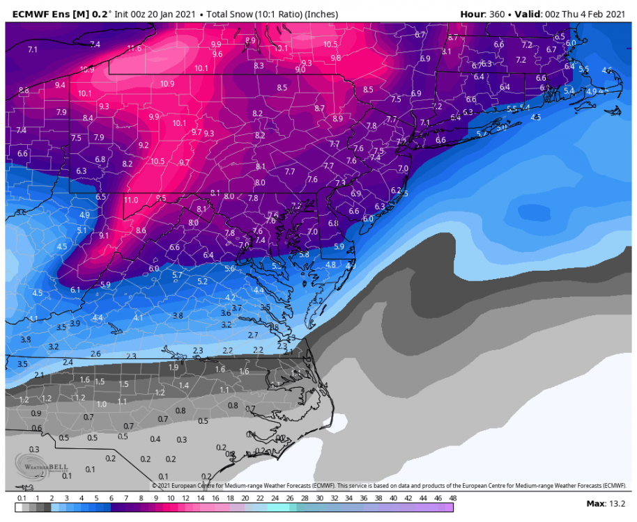
@losetoa6 this is the furthest south the cold press at mid levels gets during precip. And we can assume 850 doesn’t catch the exact warmest layer. So imo go 10 miles NW of the 0 line here and anyone south of that gets no snow on this run. This is where the 850 isotherm is as the best precip with the WAA band moves through. Anyone near or south of the line here isn’t going to get a significant snow, maybe a minor event (1-3”) before flipping but certainly nothing that would leave us feeling like we ended the curse lol remember the snow Map counts ice as snow. Even up here it looks like only about 2” of snow then changing over and we’re the northern edge of this forum. Yuck. -
January Storm Term Threat Discussions (Day 3 - Day 7)
psuhoffman replied to WxUSAF's topic in Mid Atlantic
It’s no snow in DC. There is a warm layer at 850 that never gets south of about Baltimore to Leesburg. Anywhere south of that line is pretty much all Ice or rain. Those 2 are the same to me (I have no interest in ice) so I don’t bother to dig into that but it’s definitely no snow that run in DC. Yes some freezing rain. -
January Storm Term Threat Discussions (Day 3 - Day 7)
psuhoffman replied to WxUSAF's topic in Mid Atlantic
I love your optimism but let’s be real since most can’t see the run. The 6z euro control would be a complete and utter disaster and lead to a forum meltdown. It’s all rain for anyone south of a Baltimore to leesburgh line and even up here it’s only a few inches changing to ice/rain. The entire DC area gets no snow...again. -
Feb Long Range Discussion (Day 3 and beyond) - MERGED
psuhoffman replied to WinterWxLuvr's topic in Mid Atlantic
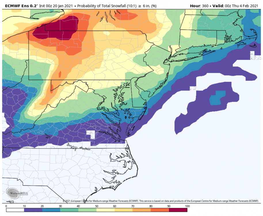
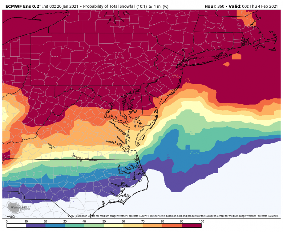
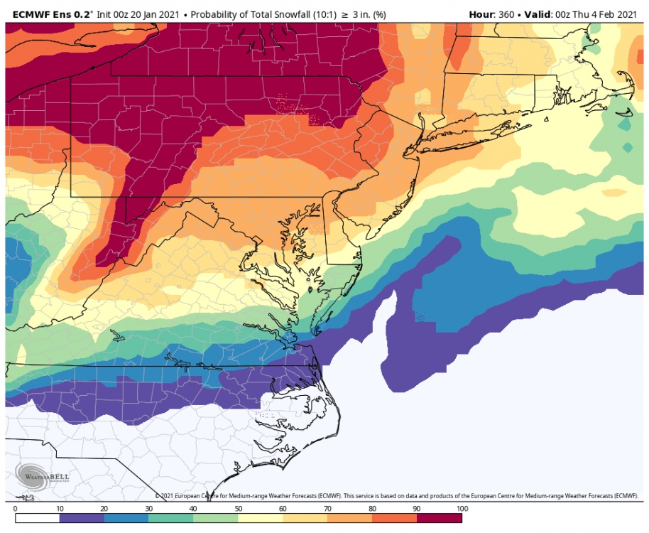
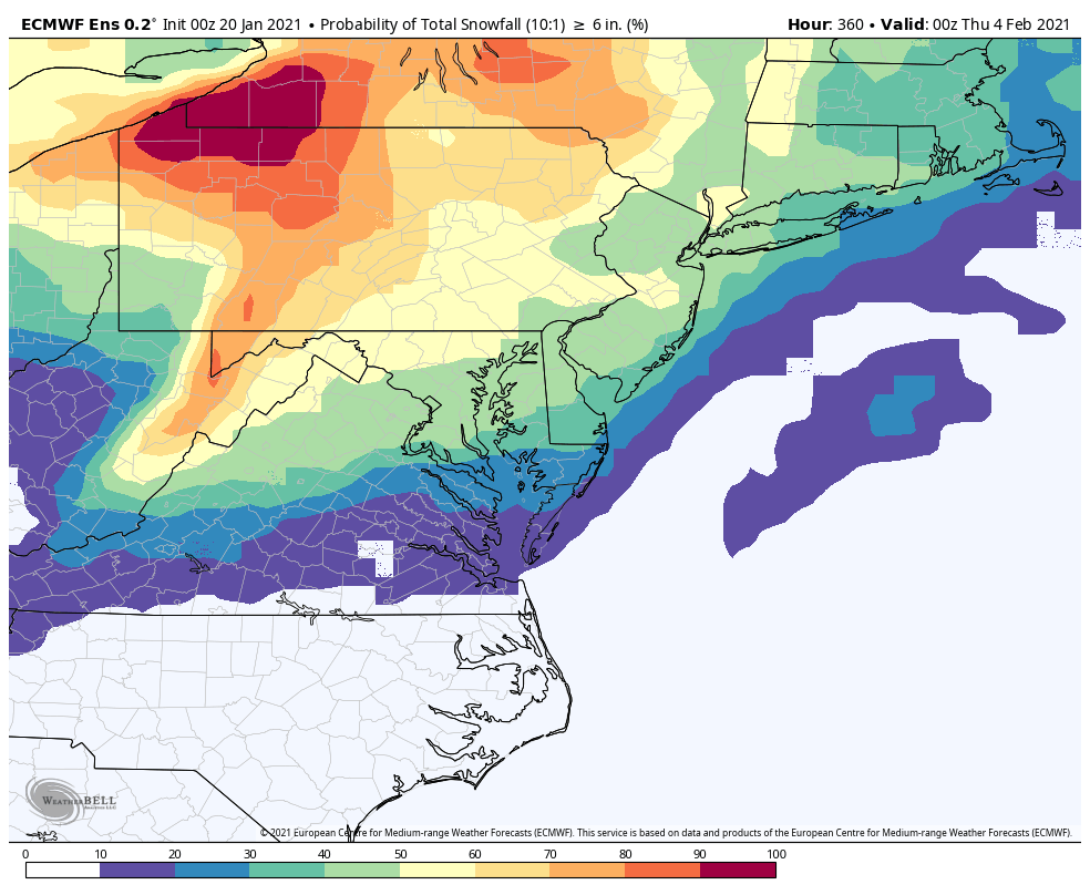
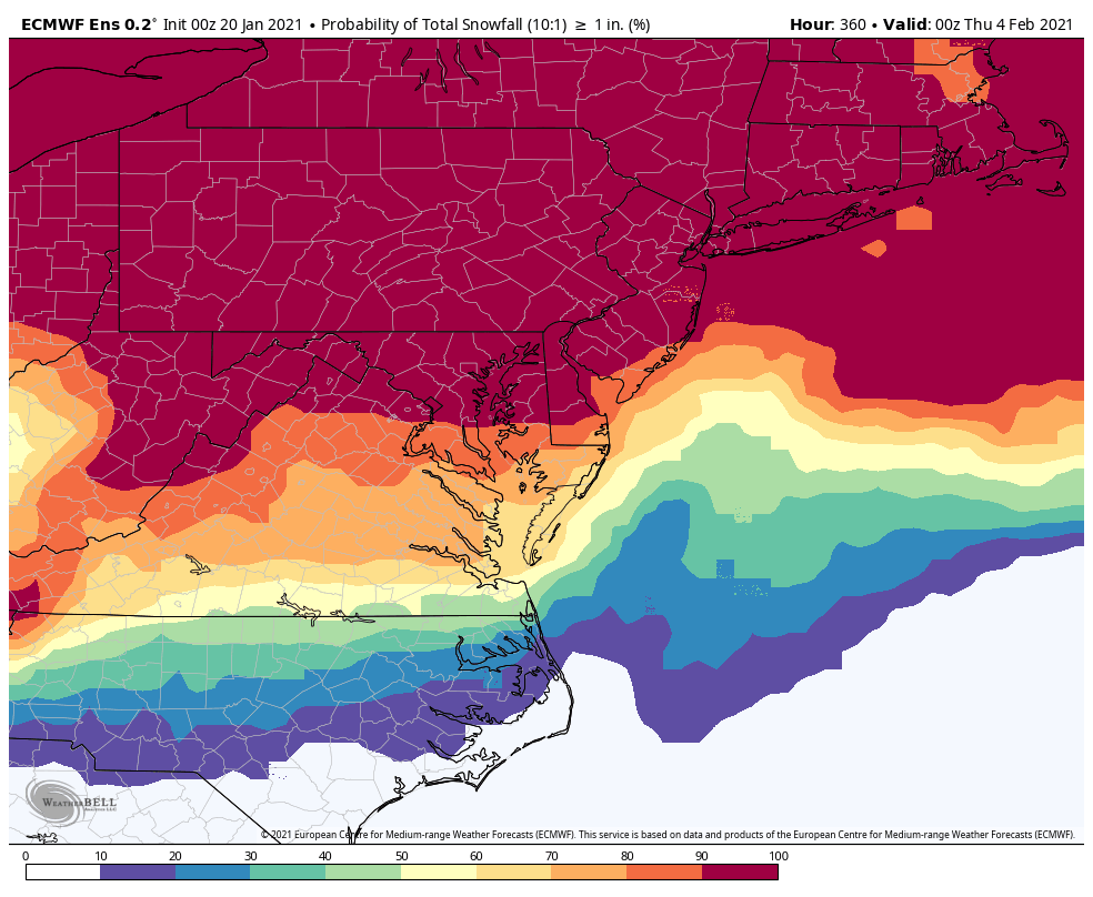
1”% 3”% 6”%