psuhoffman
-
Posts
26,289 -
Joined
-
Last visited
Content Type
Profiles
Blogs
Forums
American Weather
Media Demo
Store
Gallery
Everything posted by psuhoffman
-

January Storm Term Threat Discussions (Day 3 - Day 7)
psuhoffman replied to WxUSAF's topic in Mid Atlantic
There was a lot of water content in that storm. -
January Storm Term Threat Discussions (Day 3 - Day 7)
psuhoffman replied to WxUSAF's topic in Mid Atlantic
You really want to go there? I’m just showing the trend across guidance is shifting south. Hopefully not too far south but this wave is starting out a lot further north so I do think there is a limit to how suppressed it gets. But we fall into the trap of trying to pull details we know aren’t possible to see at range. All we can say is the setup is there for a snowstorm along the east coast next weekend. -
January Storm Term Threat Discussions (Day 3 - Day 7)
psuhoffman replied to WxUSAF's topic in Mid Atlantic
Trend last 3 GEPS -
January Storm Term Threat Discussions (Day 3 - Day 7)
psuhoffman replied to WxUSAF's topic in Mid Atlantic
Trend last 3 gefs -
January Storm Term Threat Discussions (Day 3 - Day 7)
psuhoffman replied to WxUSAF's topic in Mid Atlantic
2018 was impressive. We had snowcover for almost a week in late March. That’s crazy. -
January Storm Term Threat Discussions (Day 3 - Day 7)
psuhoffman replied to WxUSAF's topic in Mid Atlantic
I did earlier. You wouldn’t like it so much. Kinda screwed N of Philly. -
Shadow zone downslope east of the ridges. In very marginal events every little bit matters.
-
January Storm Term Threat Discussions (Day 3 - Day 7)
psuhoffman replied to WxUSAF's topic in Mid Atlantic
I think the signal for a significant event there is real. I was off by 3 days from 3 weeks lol. It’s really a redo of the setup Thursday but with a slightly more amplified wave and a slightly more relaxed flow over the NE. But yea we can’t lock in any details yet. It could end up Richmond or Boston...or maybe it’s finally our turn. -
January Storm Term Threat Discussions (Day 3 - Day 7)
psuhoffman replied to WxUSAF's topic in Mid Atlantic
Great catch. I’ve studied March 58 extensively. It’s one of my favorite historic storms. 30-50” in this area. Lol. There actually was a low in the upper Midwest before March 58. It was very weak though... more upper level support then surface feature. But the initial wave on the trough did run up to the lakes with the upper low in upper Midwest. But it was a VERY similar setup with the remnants of a decaying Rex block that had retrograded and was dying in southeast Canada. The combo of that ridge and the vortex in the western Atlantic forced that upper low in the upper Midwest to dive southeast and it eventually activated and phased with the STJ wave along the southeast. But because of the block the upper low progression was very slow so the storm essentially was stuck as the upper support slowly caught up and the system went through several pulses of development. It was an incredibly similar setup to what guidance is projecting. Doesn’t mean we get THAT same outcome. That was a Max potential kind of thing where it all came together perfectly. DC would have had 40” of snow had that been in Feb btw. The boundary layer was just too warm that late. FWIW 1958 has been showing up in pattern analogs a lot the last 2 months. -
January Storm Term Threat Discussions (Day 3 - Day 7)
psuhoffman replied to WxUSAF's topic in Mid Atlantic
March 20/21 2018 was similar. Severely blocked system that tried to cut and got forced under. WAA wave followed by secondary redevelopment from the next vort to amplify the originally dying trough. Being March 20 the first WAA didn’t work out in the cities. But as I’ve said that storm moved a few weeks earlier would be a HECS for DC. Also a Nina year with an NAO block. -
January Storm Term Threat Discussions (Day 3 - Day 7)
psuhoffman replied to WxUSAF's topic in Mid Atlantic
Looks like euro control run -
January Storm Term Threat Discussions (Day 3 - Day 7)
psuhoffman replied to WxUSAF's topic in Mid Atlantic
Thanks for the reminder lol. The eps has a tendency to skew towards the mean for any given pattern. In fairness when storms actually hit we do beat those maps. When we get on a heater some years we crush those 10 day means. But it’s been a long time we’ve been underperforming patterns. -
January Storm Term Threat Discussions (Day 3 - Day 7)
psuhoffman replied to WxUSAF's topic in Mid Atlantic
When even dr no says yes...if we still fail... -
January Storm Term Threat Discussions (Day 3 - Day 7)
psuhoffman replied to WxUSAF's topic in Mid Atlantic
Ya you have just been a while. That’s typically when they really happen. -
January Storm Term Threat Discussions (Day 3 - Day 7)
psuhoffman replied to WxUSAF's topic in Mid Atlantic
I’m getting pretty frustrated but I’ll never stop tracking. -
Feb Long Range Discussion (Day 3 and beyond) - MERGED
psuhoffman replied to WinterWxLuvr's topic in Mid Atlantic
Signs increasing the NAO tanks again in 10-15 days. -
January Storm Term Threat Discussions (Day 3 - Day 7)
psuhoffman replied to WxUSAF's topic in Mid Atlantic
It’s likely to warm up after that storm unless it really bombs and forms another 50/50. Then maybe we get an ice threat or at least not a huge warm surge ahead of the next wave. But that wave is likely to amplify west of us. The NAO breaks down temporarily and as it reloads (yep the NAO looks to tank again in 10-15 days) the next trough is likely to amplify in the central US. -
January Storm Term Threat Discussions (Day 3 - Day 7)
psuhoffman replied to WxUSAF's topic in Mid Atlantic
Euro has a couple nice looks when it was way out at day 8-10 range -
January Storm Term Threat Discussions (Day 3 - Day 7)
psuhoffman replied to WxUSAF's topic in Mid Atlantic
@losetoa6 I got 30” from one of those 2010 storms on 1.5 qpf! -
January Storm Term Threat Discussions (Day 3 - Day 7)
psuhoffman replied to WxUSAF's topic in Mid Atlantic
That’s 10-1. You know what our ratios would be with 1.3 qpf on the northern fringes of a bombing coastal and -9 850s... plus that weird fujuwara it does with the precip as the coastal takes over never actually happens. It’s a model bias. -
January Storm Term Threat Discussions (Day 3 - Day 7)
psuhoffman replied to WxUSAF's topic in Mid Atlantic
GEPS loves that threat too. Gefs is more north (good!!!!!)

-
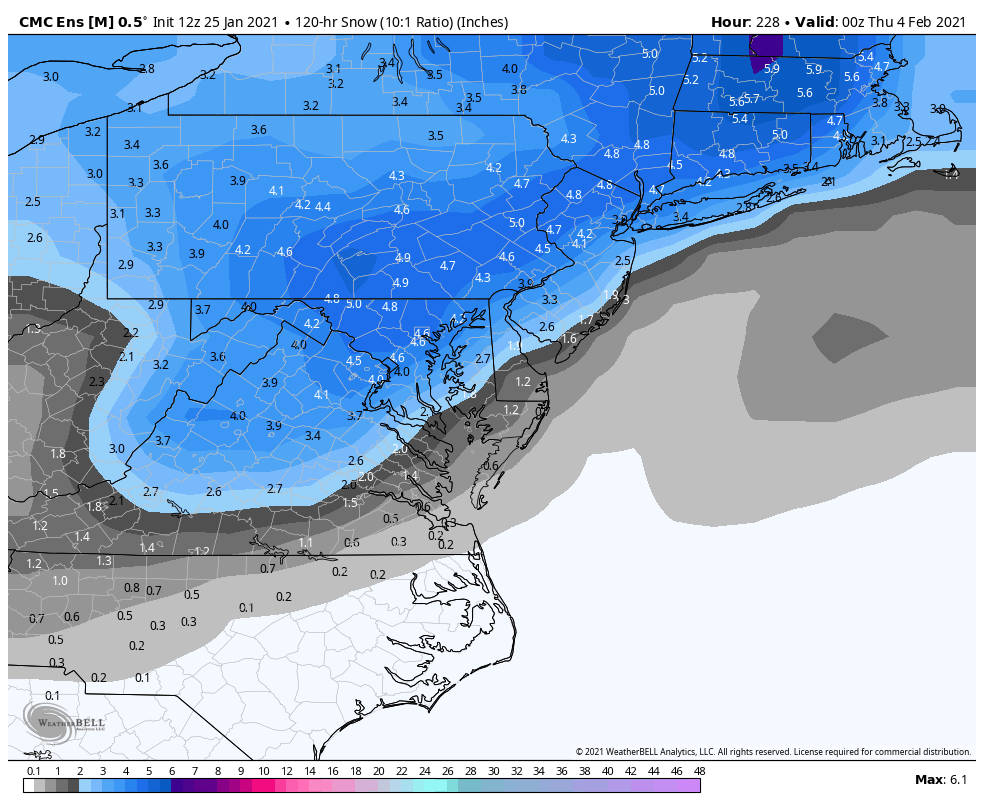
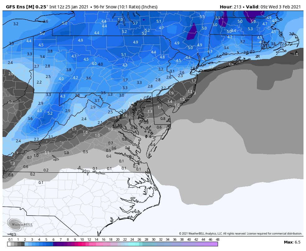
January Storm Term Threat Discussions (Day 3 - Day 7)
psuhoffman replied to WxUSAF's topic in Mid Atlantic
This is the mean for the whole storm. You need to use the 72 hour snow mean to capture it all because there are some timing differences and some members have the secondary stall and linger.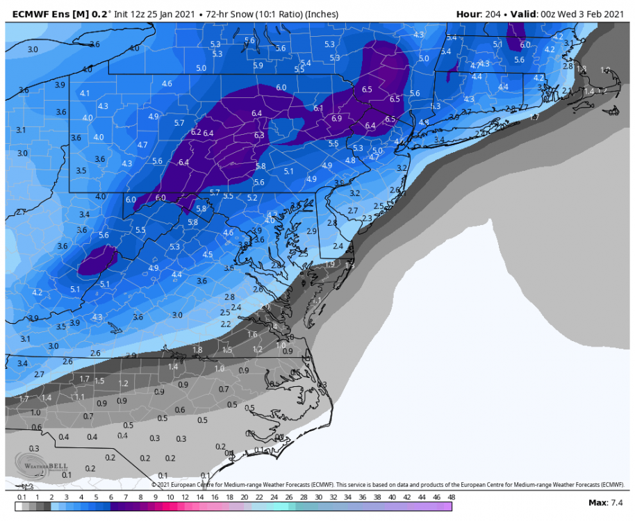
-
January Storm Term Threat Discussions (Day 3 - Day 7)
psuhoffman replied to WxUSAF's topic in Mid Atlantic
Just once... -
January Storm Term Threat Discussions (Day 3 - Day 7)
psuhoffman replied to WxUSAF's topic in Mid Atlantic
You would think if we keep getting GOOD setups one has to work eventually. Right lol -
At least some people still know what's up