psuhoffman
-
Posts
26,289 -
Joined
-
Last visited
Content Type
Profiles
Blogs
Forums
American Weather
Media Demo
Store
Gallery
Everything posted by psuhoffman
-

January Storm Term Threat Discussions (Day 3 - Day 7)
psuhoffman replied to WxUSAF's topic in Mid Atlantic
That and it’s 18z so they are also skewed by those suppressed members where by then it’s sunny and 42 degrees because suppressed or not the cold gets scoured by the ridging ahead of the wave and only floods back in if it amplified. So those weak OTS members are also likely pretty warm at 1pm. Add in they are low resolution so likely a bit too warm across the members with a storm also. I would worry way more about the h5 and surface mslp then the surface temp mean at that range. -
January Storm Term Threat Discussions (Day 3 - Day 7)
psuhoffman replied to WxUSAF's topic in Mid Atlantic
That track is freaking perfect for a classic snowstorm. If a low tracking over VA beach and tucked in just east of the VA capes doesn’t work on Feb 1... -
January Storm Term Threat Discussions (Day 3 - Day 7)
psuhoffman replied to WxUSAF's topic in Mid Atlantic
Yes, I think some were rooting for that ridge to pump more but that doesn’t work when it’s centered east like that. There isn’t enough space for the wave to dig, amplify, and turn the corner and lift. It’s unlikely to gain much latitude once the secondary forms and gets captured. If it digs too much it won’t recover. We’re so used to wanting things to dig more but this is a case where imo were better off with less ridge and less digging. Let the h5 feature slide ESE and capture the secondary off the VA capes not down off NC. EPS likes that option. -
January Storm Term Threat Discussions (Day 3 - Day 7)
psuhoffman replied to WxUSAF's topic in Mid Atlantic
EPS is still more important at this range. Still outside 100 hours. -
January Storm Term Threat Discussions (Day 3 - Day 7)
psuhoffman replied to WxUSAF's topic in Mid Atlantic
You’re being optimistic? What is happening. -
January Storm Term Threat Discussions (Day 3 - Day 7)
psuhoffman replied to WxUSAF's topic in Mid Atlantic
EPS is worthy of tears. It’s beautiful. Makes that op run a little easier to take. But given a few factors, seasonal trend, the location of the upper level ridge in Canada and the associated flow over New England and the fact the western ridge is centered east of the Rockies...I am more worried about suppressed then a cutter as a total fail here. Suppressed might not necessarily mean it all stays south...could do a split like this storm yesterday where the WAA associated wave gets suppressed south and a northern feature kinda weakly meanders to our NW and we barely get any precip. But the issue with that kind of outcome is still suppression because imo with the cold, the high location, and the flow to our north even an amplifying wave that tries to cut would give us a nice warning level thump snow. The only path to a fail I see is if the storm starts to get suppressed by the flow (like everything else lately) and can’t amplify to the coast. So I’m definitely not tossing any towel, it’s a good setup, but I don’t like seeing the best operational trend towards my fail option. Btw it’s really rare lately for the ensembles (gefs or eps) to disagree so strongly with the op in the day 4-6 range anymore. I’ve noted that in recent years they’ve become mostly a “yea that” chorus of affirmation. I have no idea why they seem to align with the op more frequently. Maybe the ops are better and have less hiccup runs anymore. Obviously they can be wrong but not in ways inconsistent with their own physics so the ensembles can’t see that error either. Interesting that this run the eps diverged so strongly from the op. The optimist in me wants to believe the op was just a hiccup. -
January Storm Term Threat Discussions (Day 3 - Day 7)
psuhoffman replied to WxUSAF's topic in Mid Atlantic
Btw we don’t want the ridge out west pumping more. It’s too Far East and positively tilted. The more that pumps the more pressure to dig the trough into the southeast it exerts. We don’t want that. There is too much blocking for that. We want the h5 to track ESE across VA not dive SE into NC! We have a beautiful wave that is blocked from lifting we don’t want it to dig and get squashed in the flow. We want it to slide more east and develop the low off the mid Atlantic not the southeast. -
January Storm Term Threat Discussions (Day 3 - Day 7)
psuhoffman replied to WxUSAF's topic in Mid Atlantic
I was worried about that trend BEFORE this run but no one wanted to listen because the run showed 40”. I said yea but now we are one more adjustment exactly like the last 3 runs from a suppressed solution but everyone was sure the south trend would magically stop now that they were in the bullseye. Look maybe this was a bad run. EPS not out yet. Maybe euro over corrected. Maybe this time we get a compromise. It’s not 100%. But that h5 low was shifting south consistently too much every run for me to be comfortable given the seasonal trend for storms that were cutters day 8 to end up suppressed waves that can’t even get much precip to us. -
January Storm Term Threat Discussions (Day 3 - Day 7)
psuhoffman replied to WxUSAF's topic in Mid Atlantic
Messy transfer. The euro amplified the h5 low and rolls it through with a clean transfer and phase with the secondary. The other guidance gets to the Ohio valley then gets messy. The upper level low broadens and starts to pinwheel around and the secondary can’t really amplify and develop a nice clean closed circulation to get that ccb going. -
January Storm Term Threat Discussions (Day 3 - Day 7)
psuhoffman replied to WxUSAF's topic in Mid Atlantic
Yes but if the further north primary idea of the gfs/Cmc is correct it’s a split threat. WAA wave gets suppressed coastal forms late. We’re stuck in between. Always something waiting to steal out snow man. -
January Storm Term Threat Discussions (Day 3 - Day 7)
psuhoffman replied to WxUSAF's topic in Mid Atlantic
Too far west...tucks in slightly too tight. But I don’t buy a lot from off VA beach ending up inland over NJ. But one reason that run is icon takes too long to progress the h5 east. -
January Storm Term Threat Discussions (Day 3 - Day 7)
psuhoffman replied to WxUSAF's topic in Mid Atlantic
Gefs trends -
January Storm Term Threat Discussions (Day 3 - Day 7)
psuhoffman replied to WxUSAF's topic in Mid Atlantic
It (oddly I don’t but it) holds onto the primary longer. But it’s a lot colder before the 6-12 hours or so that screws up our thermals. But despite that it’s still closer to getting us with a coastal after. If you remove the primary hanging on so long this was a pretty big jump the right way otherwise Imo. -
January Storm Term Threat Discussions (Day 3 - Day 7)
psuhoffman replied to WxUSAF's topic in Mid Atlantic
It’s a colder run then 18z though. -
January Storm Term Threat Discussions (Day 3 - Day 7)
psuhoffman replied to WxUSAF's topic in Mid Atlantic
Cmc is definitely not the euro. But it’s kinda a half way solution between the euro and gfs. Sound familiar? When did we have that scenario. -
January Storm Term Threat Discussions (Day 3 - Day 7)
psuhoffman replied to WxUSAF's topic in Mid Atlantic
Depends what happens with the secondary after 120 but it’s a decent WAA thump first. Especially for DC southeast. -
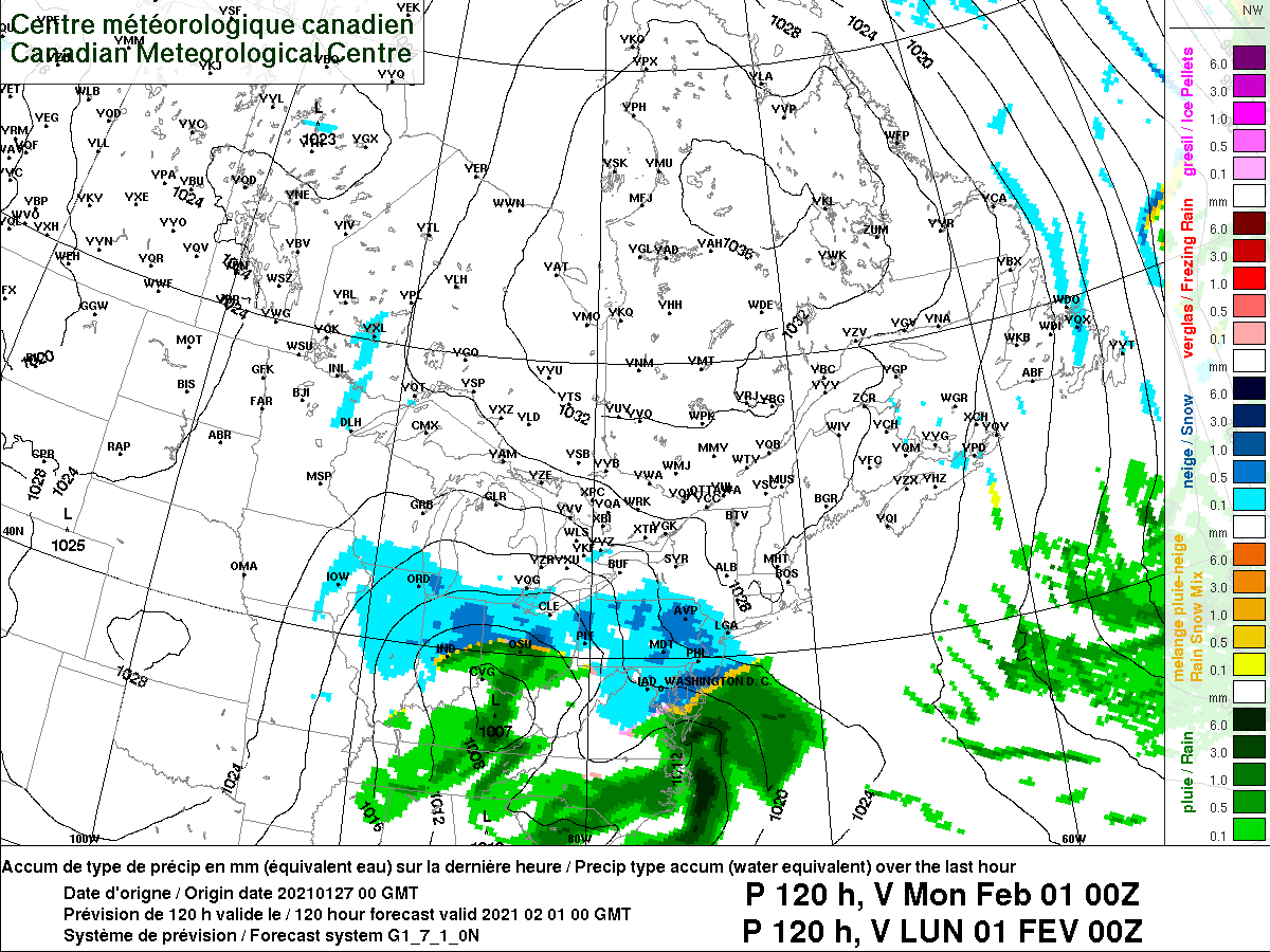
January Storm Term Threat Discussions (Day 3 - Day 7)
psuhoffman replied to WxUSAF's topic in Mid Atlantic
Cmc at 120
-
January Storm Term Threat Discussions (Day 3 - Day 7)
psuhoffman replied to WxUSAF's topic in Mid Atlantic
Yup. The euro rolls the upper level through amplifying the whole way. The gfs stalls the trough in the Midwest then becomes a diffuse mess opening up a broad h5 circulation. Weird. -
January Storm Term Threat Discussions (Day 3 - Day 7)
psuhoffman replied to WxUSAF's topic in Mid Atlantic
Another tick south. Trend -
January Storm Term Threat Discussions (Day 3 - Day 7)
psuhoffman replied to WxUSAF's topic in Mid Atlantic
Technically I flip to a lot of sleet after about 5” of snow but I doubt it with that track and h5 capture and pass. Typically those systems wind up with tightly would thermals. -
January Storm Term Threat Discussions (Day 3 - Day 7)
psuhoffman replied to WxUSAF's topic in Mid Atlantic
Icon secondaries off VA beach and tracks the h5 right across N VA but it captures too soon and tucks the low due north up onto NJ before sliding east. Get rid of that and it’s a better run. I didn’t mind this run at all. -
January Storm Term Threat Discussions (Day 3 - Day 7)
psuhoffman replied to WxUSAF's topic in Mid Atlantic
We melt for opposite reasons. You melt down when you know it’s going bad. I melt down when I think it should go good and get nervous at any little sign that has the potential to derail a rare opportunity. -
January Storm Term Threat Discussions (Day 3 - Day 7)
psuhoffman replied to WxUSAF's topic in Mid Atlantic
First I think people misunderstand when I fret about something. Notice I don’t pitch a fit when a relatively minor event evaporates. I don’t when a setup we knew was iffy falls apart. But when I think something has truly rare potential...a setup we don’t get often...one I don’t want to waste because it might not come again soon...when I actually think we will get a good snowstorm, that’s when I am picky and fret at any little sign it might fall apart. We have more to lose. So me fretting is a GOOD thing. It means Im invested and actually think we will get snow. If I didn’t I wouldn’t care about a slight trend here or there. But we kinda wasted one of these opportunities in December. It underperformed potential. We wasted one this week. So yea this is the 3rd crack at imo a really good high potential event and I’d like to not strike out considering we can go years without getting these kinds of patterns and setups. We can’t afford to waste them. Now as for why suppression is a risk even if smaller then the last few waves. Keep in mind we need suppression. We’re south of the mean storm track when there is none. But too much of a good thing and it’s congrats Richmond. I don’t think this can go too much further but I’d rather not test that theory. The blocking is relaxing but not gone yet. that upper low is a beaut but the spacing is still a little tight. The ridge axis out west is east of the canonical Boise target and positively tilted. That could put pressure on the wave and make it progressive or dig too far into the southeast. The flow to the northeast is also still pretty suppressive. The 50/50 is vacating but the timing is close. It’s not a sure thing. That high in Canada (remnants of the block) is pretty far south. All it would take is for that upper low to take the red track v the green and Baltimore north is smoking citrus whole VA and NC get snow. That doesn’t mean I think that’s happening. I don’t. But it’s the most likely fail so I don’t want to see even a hint of guidance moving that way. Not even a bit. ETA: this panel is absolutely beautiful and rare for an ensemble at 144 but all it would take for a miss to the south is to adjust that to the red circle. Given the trend...48 hours ago that h5 low was up in New England, and we’re not 100% safe from that YET. Frankly 1-2 more adjustments like the last several runs and were in trouble. If we see the euro stabilize tonight and tomorrow with no further shift south (and I mean NONE not this thing we do where we try to ignore or excuse it away like oh it’s just noise) then I will feel a lot better. -
January Storm Term Threat Discussions (Day 3 - Day 7)
psuhoffman replied to WxUSAF's topic in Mid Atlantic
Lol I’m not pessimistic. If I didn’t think I had a good chance of actually getting this one I wouldn’t be as nervous wrt what could go wrong. I don’t fret when I know it’s going to fail. It’s when I know a setup has extremely rare potential that doesn’t come along often that it would hurt bad if it fails. Imo the bigger threat to a fail for my location is suppressed. So seeing the eps nudge south again (when frankly I was in the bullseye up here 2 runs ago already) isn’t what I want to see. It just isn’t. Given the seasonal trend why would anyone want to see a south trend when we’re still 130 hours away? So perspective I still am optimistic. But that’s why I don’t want to see any hint at the setup unraveling. Even if it’s just the tiniest little speck of a hint. -
January Storm Term Threat Discussions (Day 3 - Day 7)
psuhoffman replied to WxUSAF's topic in Mid Atlantic
Thanks for the write up. That’s the control btw though. This is the eps mean same time. Just for reference. The eps mean is a little better then the 18z control imo. Control dove the h5 low too far south for my liking.