psuhoffman
-
Posts
27,418 -
Joined
-
Last visited
Content Type
Profiles
Blogs
Forums
American Weather
Media Demo
Store
Gallery
Everything posted by psuhoffman
-
It’s been nice. Took the kids to Christmas Tree Park in Manchester. Last of the snow hanging by a thread today...
-
Gefs still interested

-
They’re laughing at us!
-
I said Gefs. There are some members that are wet. But it’s still not in details range anyways. I’m not really paying much attention. Just made a half joking observation.
-
Then it targets just north layer in the week. I suppose one more DC split would be a perfect way to end things.
-
The one you declared dead.
-
p28 seems to fit the seasonal pattern.
-
its not crazy for that range though... some subtle shifts in the longwave pattern at that range has significant impact on the synoptic details. Maybe it shifts back next run who knows...but that's why I was lol at the "its over" posts the last 24 hours. I would be equally LOL at any "it's gonna snow" posts too. Maybe the winter got to everyone because some people are acting silly lately with making determinations about synoptic details from ranges that are not realistic.
-
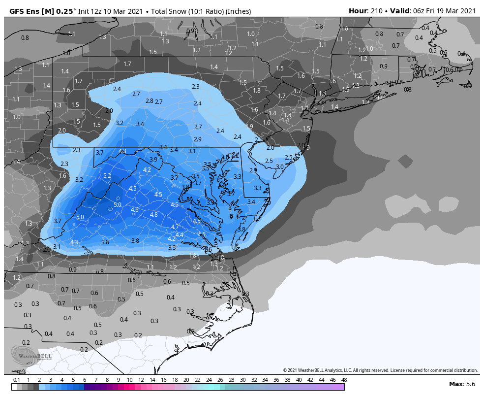
GEFS targets central VA. Right where we want it lol
-
@CAPE also I’ve moved on. I had a health issue and got a family function coming up and besides that I’m totally swamped at work now. So I’d love another snow but if we don’t get another flake I won’t blink. But I find the “it’s over” posts amusing. Maybe it is. Maybe it isn’t. I don’t ever assume anything that has happened multiple times won’t happen again.
-
I get ya. I think Ji was being more universal in his post though.
-
Dunno...I never thought it was likely and still don’t but I also still wouldn’t be shocked if the area saw another snow either. Honestly I feel people are letting their disappointment and desire to be done with winter to cloud their judgement. We know it can snow in late March. And yes even on the coastal plain. It’s pretty rare. Like a 5-10% probability (of something more then just mood flakes) in any year type thing. But that’s not “no way” like people keep saying. And the fact the winter was a disappointment until now also doesn’t have that much correlation. Some years with late snow were pretty dismal before that also. I kinda feel like this is more people’s desire to have warm weather and not suffer one more disappointment.
-
Micro v macro. Your zooming in on a specific synoptic setup which wasn’t even in range when I made that observation. On the longwave pattern level there are some similarities with an elongated TPV from Siberia down into SE Canada as the driving mechanism to get cold here and suppress the storm track. The 18z op gfs adds a wrinkle with a -NAO also but thats not across the majority of guidance...yet?
-
52
-
March is typically too volatile to get a threat to lock in at super long leads. If something does come up it likely won’t show itself clearly until inside 5/6 days and even that might be pushing it.
-
Im 100% content if it’s over. Just rolling with whatever.
-
He’s exaggerating. You’ll get at least 2
-
Lol what lol. This is a winter default map for 2 weeks Yes WINTER default and every other post here has been repeating “spring” and “it’s over”
-
Lol
-
Can yoga do play by play for member p02
-
Some people are being silly. A few observations. Guidance is all displacing a now strengthening tpv lobe into Quebec the second half of March. This leads to a trough amplification into the east. This is a very different mechanism for cold then earlier this winter and right now. It’s more similar to the cold periods we saw in March 2014 and 2015. That doesn’t mean it will snow. It’s very late. Even in a good pattern we need luck. If I had to bet I would bet no. But that doesn’t mean it’s impossible. It can snow in late March. Everyone in here knows that. And everyone also knows just because they had bad luck in January and February doesn’t guarantee bad luck in March. So people need to stop it with the fatalistic projection or reverse psychology stuff. Just because you’re disgusted about this winters results and personally done with winter doesn’t mean it can’t snow. The weather don’t care. Do I think it’s going to snow? Probably not. But it could, the pattern looks somewhat favorable, so I find the posts making definitive declarations that something that has happened even recently (late March snow) cannot possibly happen to be silly!
-
You’re doing play by play on the 300 hour gfs???
-
FULL TUCK
-
? It actually looks pretty good to me...
-
I’ll have to confirm but I think the 13.8 is the new 30 year. If it’s 10 I agree that’s sketchy. I think 30 is necessary since we know the climate is changing. Anything longer will skew cold/snowy compared to the current situation.