psuhoffman
-
Posts
26,324 -
Joined
-
Last visited
Content Type
Profiles
Blogs
Forums
American Weather
Media Demo
Store
Gallery
Everything posted by psuhoffman
-
Wave 2 doesn’t seem to want to gain any latitude
-
It’s a nice run so far if you are in DC or anywhere north. More amplified so more precip and from DC north is cold enough. It’s not like 12z that blasted the 850s way north. But south of DC has mixing issues so not as good there. Anyone south of DC needs to root for a weaker wave to have a shot. More amplified probably pushed the boundary north of them. But they could still score Friday depending what happens with the trailing energy.
-
Also more juiced with the wave to the west. Rare combo
-
Slight decrease overall because the losses from wave 1 slightly offset the gains from wave 2. Wave 2 is the potentially more dynamic and fun but wave 1 was closer. Whatever. There isn’t much separation between the two anymore either. There is really no lull anymore. Just a long fetch it weak WAA precip ahead of the main wave (2nd) now. The first wave isn’t even a distinct entity anymore imo.
-
It’s over at 90. If you look at the 1 hour precip it’s moving off the coast by then.
-
Some people don’t heed warnings
-

Feb Long Range Discussion (Day 3 and beyond) - MERGED
psuhoffman replied to WinterWxLuvr's topic in Mid Atlantic
Anyone ever wondered what would happen if we got the western N American pattern of 1994 but with a -NAO. We might be about to find out. -
Feb Long Range Discussion (Day 3 and beyond) - MERGED
psuhoffman replied to WinterWxLuvr's topic in Mid Atlantic
This is cray cray so the next 15 days is... and then it REALLY gets good lol -
Feb Long Range Discussion (Day 3 and beyond) - MERGED
psuhoffman replied to WinterWxLuvr's topic in Mid Atlantic
It’s there but like the op weaker and gets going late for big snowstorm here. Supports a light snow. Colder then op. It really likes next week. -
Feb Long Range Discussion (Day 3 and beyond) - MERGED
psuhoffman replied to WinterWxLuvr's topic in Mid Atlantic
1960s redux -
Feb Long Range Discussion (Day 3 and beyond) - MERGED
psuhoffman replied to WinterWxLuvr's topic in Mid Atlantic
EPS all over next week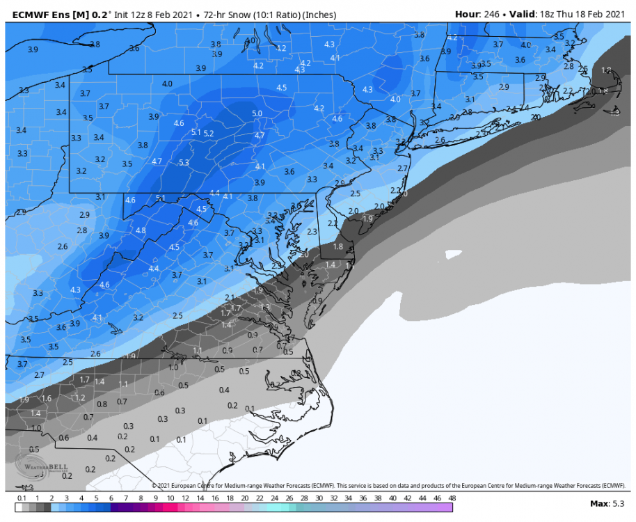
-
Feb Long Range Discussion (Day 3 and beyond) - MERGED
psuhoffman replied to WinterWxLuvr's topic in Mid Atlantic
Yea but imagine the mess if we were posting about all these threats in one thread. -
Feb Long Range Discussion (Day 3 and beyond) - MERGED
psuhoffman replied to WinterWxLuvr's topic in Mid Atlantic
-
Feb Long Range Discussion (Day 3 and beyond) - MERGED
psuhoffman replied to WinterWxLuvr's topic in Mid Atlantic
I think this pattern runs into March and we eventually just run out of season. -
-
would think it sucks more for everyone else having to read my posts in the wrong threads
-
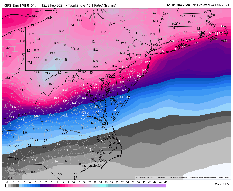
Since 1990 La Nina February's with a -NAO average 16" of snow at BWI.
-
dunno I'm kinda slow
-
I hope this one doesn't adjust as far north...I think 95 is in better shape here...by 72 the euro wasnt THAT far south and this time the max is a little south of DC. The last few times DC was already kinda hangin by a thread by 72 hours. Plus there is some legit cold in the pattern now. I am willing to take a good but not great snow up here to get DC/Baltimore to finally jack.
-
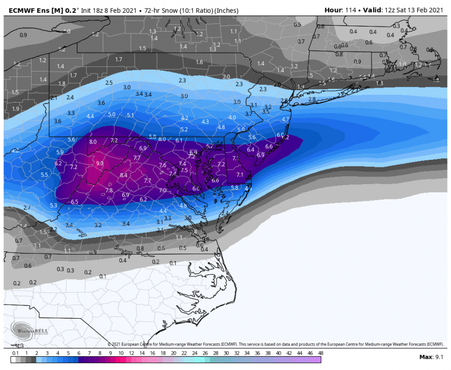
Remind me again...where has the maximum ended up compared to where the Euro had it 72 hours out?
-
What you didnt want to read the next 3 pages about that?
-
Is it a good thing when it gets confusing keeping up with all the different threat threads?
-
The euro has been a little too far south all winter...this is PERFECT where it is now for an eventual DC to Baltimore jack!
-
it comes north but the heavy snow is central VA. But we get a decent snow from the second wave. It's a nice storm for the whole area but it's best down in central VA. BTW kinda reminds me of that one Feb 1996 event that was kinda like that.
-
It’s 8-10 from all 3 waves. And I’ll take it lol. But there are some periods of light snizzle that wouldn’t be accumulating snow but add up to an extra .1-.2 qpf and inflate that a tiny itsy bit. Still a good run. Not arguing that at all.