

psuhoffman
-
Posts
26,409 -
Joined
-
Last visited
Content Type
Profiles
Blogs
Forums
American Weather
Media Demo
Store
Gallery
Everything posted by psuhoffman
-

December 2021 Medium/Long Range Discussion Thread
psuhoffman replied to North Balti Zen's topic in Mid Atlantic
I had 103” that winter. At one point in Feb there were drifts up to roofs. I would sign up for several bad winters to experience that again. some pics from a walk I took into town that year. -
I just realized since moving up here March is the month most likely to produce a warning level snowfall. Probably why I get annoyed when people start talking about spring in February.
-
December 2021 Medium/Long Range Discussion Thread
psuhoffman replied to North Balti Zen's topic in Mid Atlantic
Lastly I would gladly suffer the same fate for what came next…. -
December 2021 Medium/Long Range Discussion Thread
psuhoffman replied to North Balti Zen's topic in Mid Atlantic
Somehow we managed to totally waste a pretty good longwave pattern Jan and Feb that winter. Did get a storm in early March. -
December 2021 Medium/Long Range Discussion Thread
psuhoffman replied to North Balti Zen's topic in Mid Atlantic
How did we waste this in January 2009? asking because this year kinda reminds me of Dec 2008 so far.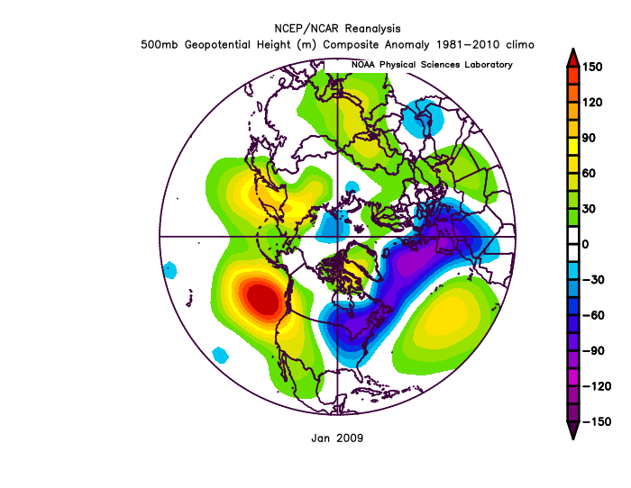
-
December 2021 Medium/Long Range Discussion Thread
psuhoffman replied to North Balti Zen's topic in Mid Atlantic
That screams cold/dry warm/wet to me. We need the epo ridge to extend into western Canada without blocking. An epo ridge with no blocking tends to have storms cut to our west. We get cold behind them but I don’t see what would keep any amplified storm under us in that look. Could see ice perhaps in that setup. It’s forever out. What we need is either for that epo ridge that shift east or for the NAO to go negative -
December 2021 Medium/Long Range Discussion Thread
psuhoffman replied to North Balti Zen's topic in Mid Atlantic
The one way this could work would be if the guidance is wrong wrt the depth of the cold from that range. That isn't an impossible error but it does go against usual bias at this range and has the time of year working against it and there are a ton of other ways this could trend all of which equal no snow. So imo by far the most likely end result is more wet than white but I suppose its not completely hopeless. -
December 2021 Medium/Long Range Discussion Thread
psuhoffman replied to North Balti Zen's topic in Mid Atlantic
This is exactly my thoughts also -
December 2021 Medium/Long Range Discussion Thread
psuhoffman replied to North Balti Zen's topic in Mid Atlantic
its too dry to work out -
New updated full list... I will be sending a "test" email soon using the list to make sure everyone is on the spreadsheet correctly. I will let you know when that happens. Wvclimo BTRWx Demeter Just654 alexderieer Mordecai TarHeelSnow RDM maestrobjwa snowenoutthere Cobalt dmac AJB jmcnemar PrestigeWorldwide poolz1 eskimojoe anotherman TSG scraff weatherShak GeorgeBM Nwbaltimorewx LP08 WxWatcher007 MattieG KMLwx snowmon WxUSAF NorthArlington101 toolsheds MillVilleWx WinterWxLuvr RandomChaos 2010extreme
-
December 2021 Medium/Long Range Discussion Thread
psuhoffman replied to North Balti Zen's topic in Mid Atlantic
I will admit I am biased since I have had some interaction with him and we go way back on the weather boards...but imo he can make good posts when he wants to and isn't putting on his "the world is ending" act that he likes to do. Granted, you have to wade through all his "the sky is falling" stuff to see them though. -
December 2021 Medium/Long Range Discussion Thread
psuhoffman replied to North Balti Zen's topic in Mid Atlantic
The good news is it literally can’t get any worse then that. That’s 100% opposite of what we want in every way. -
This is who I have as of now scraff WeatherShak georgeBM nwbaltimorewx LP08 wxWatcher007 mattieg kmlwx snowmon WxUSAF Ajb northArlington101 toolsheds MillVilleWx WinterWxLuvr Handle Wvclimo BTRWx Demeter Just654 alexderieer Mordecai TarHeelSnow RDM maestrobjwa snowenoutthere Cobalt dmac jmcnemar PrestigeWorldwide poolz1 eskimojoe
-
You will get absolutely crushed there in classic coastal storms. You will also do very well in marginal events for 95. It’s really only events that are marginal even for this area that my area will do better but those do happen a couple times a year. Last year was weird with so many of them.
-
Parrs south of Westminster is comperable to your area Imo.
-
I don’t know where he is…but in some recent crappy years I’ve noticed more of a difference between the higher ridges in northeast Carroll (Manchester area) than further south along Parrs. In a good year there isn’t much difference. In a bad year there can be when it’s barely cold enough here even. As for his old location it’s unquestionable that it’s becoming harder to get an above average snowfall year on the coastal plane. Even the few good years our “region” have had recently tended to leave them out of the party to some degree.
-
Sorry I have been really busy lately with work and some personal stuff. But I will try to go through and update the list and post later today.
-
December 2021 Medium/Long Range Discussion Thread
psuhoffman replied to North Balti Zen's topic in Mid Atlantic
I don't know if Ji was trying to hint at this or just making an IMBY post...but there is some relevance to what happens in his area and mine to the prospects for the rest of this forum. Something I noticed when I did my snowfall data study years ago was that while its very true that the DC-Baltimore area has quite a few winters where there is virtually no snow heading into January or even February and then they turn it around...that is much less true up here. And to make that worse...most of the examples where there was no significant snow up here before mid December were warm enso years where that is common...and some of those did turn it around. But when you look at enso cold or neutral years without any meaningful snowfall up here before mid December...it gets really ugly! On top of that using raw numbers from 1950 is kinda misleading...because our average snowfall is in decline. A 12" winter in 1955 equates to like a 9" winter now. The last 5 cold or neutral enso years where it didn't snow much up here before Xmas ended up being really awful winters. All 5 were significantly below average snowfall, and 4 of the 5 were single digits at BWI. What I took away from that years ago was that its not that big of a deal if DC and Baltimore and the immediate metro areas don't get much snow early in the season...it is a really bad sign when the entire region including the mountains and northern zones...are snowless early in the season. The exception is el nino years where they are notoriously warm until January and then can flip. But other seasons do tend to "tip" their hand early on. At least by the numbers... So as not to crush all hope there was one example of a nina year that started awful up here and still ended up ok...but its one example out of many...I would rather not be praying for that kind of wildly rare type of recovery. -
Mid-Atlantic winter 2021-22 snowfall contest
psuhoffman replied to PrinceFrederickWx's topic in Mid Atlantic
BWI: 14.9” DCA: 9.3” IAD: 16.1” RIC: 7.1” SBY: 4.9” -
December 2021 Medium/Long Range Discussion Thread
psuhoffman replied to North Balti Zen's topic in Mid Atlantic
January 85, 96, 00 and 11 were cold/snowy. It happens. What’s true is in really crappy Nina’s with a flat Pac ridge when it typically torches during mid winter our best chances are early before the winter pattern sets in and late as wavelengths shorten. -
December 2021 Medium/Long Range Discussion Thread
psuhoffman replied to North Balti Zen's topic in Mid Atlantic
calm down. Let’s look at Nina’s in the last 30 years. 1996 was a Nina. And yea it was one fluke and I doubt that happens again nothing is set in stone. 99/2000 And 2005/6 were near normal snowfall nina years. Both featured a big storm. 98/99, 2008/9, 2010/11, 2017/18, 2020/21 most of the region had at least one decent snowfall. Only 2001, 2012, and 2017 were total duds and even those years there was some snow and threats to track. We didn’t get lucky. But your insistence we are doomed to no snowfall due to La Niña is not supported by historical probabilities. -
Winter 2021-2022 Digital Snow Thread
psuhoffman replied to NorthArlington101's topic in Mid Atlantic
That’s exactly what I was thinking. I had 20” a week before Xmas and it was still gone by the morning of the 26th even up here! That year I had a white Xmas only by a few hours. There is a reason we get a white Xmas less than once a decade. -
Winter 2021-2022 Digital Snow Thread
psuhoffman replied to NorthArlington101's topic in Mid Atlantic
You don’t know our climo do you lol -
December 2021 Medium/Long Range Discussion Thread
psuhoffman replied to North Balti Zen's topic in Mid Atlantic
-
December 2021 Medium/Long Range Discussion Thread
psuhoffman replied to North Balti Zen's topic in Mid Atlantic
Definitely 100%. Maybe we should bump those snowstorm climo 101 threads from years ago. But I didn’t feel like typing a novel. Simply not overreacting to every random fluke op run is a good start I think but yes to really use the nwp correctly you need to apply real pattern knowledge and analysis. And let’s be honest not everyone is going to master synoptic analysis. And that’s fine…there are lots of things I don’t know Jack about.


