

psuhoffman
-
Posts
26,409 -
Joined
-
Last visited
Content Type
Profiles
Blogs
Forums
American Weather
Media Demo
Store
Gallery
Everything posted by psuhoffman
-
It doesn’t matter because it’s day 10 and whatever it showed you can’t take it exactly as is so that’s good enough. But we know how it was heading. That trough digging about to go neutral over the miss valley as the system in New England departs leaving room to amplify up the coast and fresh arctic cold in place with the rain snow line in Georgia to start as the WAA gets going. It was going to end well. Use your imagination how well.
-
Ggem was gonna smoke us as the run ended.
-
I tend to agree but I’m always open to Mother Nature surprising me. But it looks like we have a real winter this year at least.
-
That was my super secret triple dog dare version. I would have posted it sooner but I had to wait for the fire department to get it unstuck.
-
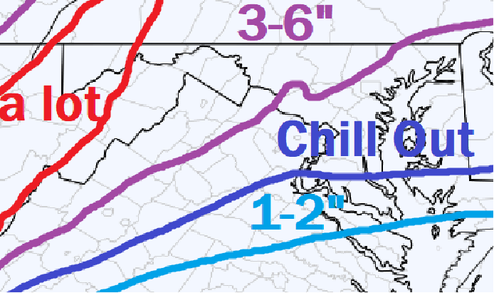
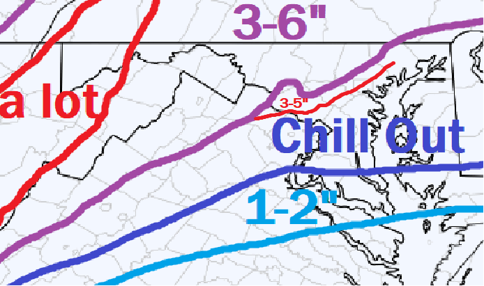
I think this worked out pretty well. I was a little low in places. I should have listened to @WxUSAF and extended the 3-6” area south a little. Could have extended the “a lot” zone northeast some as well.
-
I think the euro and 3k nam did pretty well depicting the axis of banding and general qpf totals in our area.
-
1) just don’t use the hrrr past like 1-2 hours 2) people need to see what the radar is supposed to look like. Every time we do this it’s like people see returns out in WV and western VA and expect it to be snowing in 15 mins…even if it’s not supposed to be for 8 more hours!!! They forget how attenuation works. Then they freak out over every gap or shift in the precip shield even if it’s doing exactly what it was supposed too!
-
Or maybe it was just wrong like it usually is past ~2-3 hours
-
27/26 +SN Can't tell how much, but everything's covered and its purdy and thats all that matters
-
Careful, some of the banding is now going through a zone where the radar beam is interfered with by Bull Run Mtn.
-
I guess 2 miles north of me is getting 4-8 but I can only expect 2-4. sucks
-
I enjoy the flakes in here all the time.
-
Cant wait for this event to end so we can go back to the long range. Im so over 3 hour events You're one of a kind lol
-
It's almost go time Currently the surface low is over south central VA moving ENE towards the lower Ches Bay. The upper level short wave is rounding the base of the trough in KY and about to cross through WV then VA later tonight. As that happens VV's will be increasing across the area. That area in SW VA right now I have circled is going to be the main show for the DC/Baltimore area as that lifts NE with the best vorticity associated with the mid and upper level energy. It should be fun for a few hours. This is an excellent profile to maximize snow growth across the area during the passage of this feature. I expect some nice ratios and big fat fluffy OMG flakes.
-
when I told it I said spread the word
-
Wine seems to be popular in here
-
I told it
-
I like what I am seeing now. Reports to our SW show this is overperforming if anything. That band ripping to our NW is a good thing...that banding riding along the jet was NOT supposed to be our snow. The actual radar matches the sim radar from the GFS and Euro, both of which were decent to good for our area in general. But the intensity of whats happening just to our NW shows what kind of environment we have for anyone that ends up in banding later on as the primary and upper level energy tracks across VA and we get into better lift. If anything I am MORE optimistic right now than I was earlier. Oh and chill out.
-
Best I could do
-
what the GFS said it should look like right now... LITERALLY
-
Ya I saw that but its kind of perplexing because they are getting a dump of snow tonight...and then cold through Saturday...but its going to rain pretty hard Sunday so if they don't get it open by saturday....well...the "by the END of the weekend" part is confusing.
-
Great to have you back fighting the good fight!
-
It's not THAT big a difference across guidance, we are all just obsessing over meso scale banding placement which is a nowcast detail. In a much larger storm who gets 28" v 22" isn't as big a deal. In a much "wetter" storm along the baroclinic boundary with lower ratios small .1 QPF differences arent as big a deal when were talking who gets 5" from .5 and who gets 7" from .7. But this is a type of setup where small qpf differences make a big OTG difference but that fact still doesn't make us any more able to place meso scale features accurately. They just told ya'll to chill out too I did my job, you have been lead to water trough...its not my fault if you dive head first into it and drown!
-
tell them to get western territory open for my by Saturday!


