

psuhoffman
-
Posts
27,419 -
Joined
-
Last visited
Content Type
Profiles
Blogs
Forums
American Weather
Media Demo
Store
Gallery
Everything posted by psuhoffman
-

Jan 24-26 Weekend Snow and Sleetfest Model Thread Part Tres
psuhoffman replied to H2O's topic in Mid Atlantic
It’s because the warm layer is at its greatest extent there and thin and it’s wobbling based on rates. Around 20z we’re in a dry slot then it sinks south during some heavier precip -
Jan 24-26 Weekend Snow and Sleetfest Model Thread Part Tres
psuhoffman replied to H2O's topic in Mid Atlantic
@wxmeddler I think bc you let us know about the Dr U convo you were gonna be low. I sorta expected that too, unfairly. -
Jan 24-26 Weekend Snow and Sleetfest Model Thread Part Tres
psuhoffman replied to H2O's topic in Mid Atlantic
Looks like the gfs only the CAM version -
Jan 24-26 Weekend Snow and Sleetfest Model Thread Part Tres
psuhoffman replied to H2O's topic in Mid Atlantic
Not saying it’s right but the range thing isn’t why because it does things that lead to this result in just 24 hours. Now the it sucks issue might be why. -
Jan 24-26 Weekend Snow and Sleetfest Model Thread Part Tres
psuhoffman replied to H2O's topic in Mid Atlantic
I actually like the 18z rgem slightly better than 12z. WTF I’m out. I need to find something less stressful and more reliable. Oh I know I’ll start rooting for the local sports teams! -
Jan 24-26 Weekend Snow and Sleetfest Model Thread Part Tres
psuhoffman replied to H2O's topic in Mid Atlantic
Ok rgem calms my soul some -
Jan 24-26 Weekend Snow and Sleetfest Model Thread Part Tres
psuhoffman replied to H2O's topic in Mid Atlantic
I had hoped 12z meant we finally stopped the bleeding. But what’s come out so far 18z resumed what had been the trend prior to 12z and in most cases lost all progress from 12z and ended worse than their 6z runs! hopefully rgem/gfs/euro come in bucking this trend but so far a major amp trend with the primary across 18z -
Jan 24-26 Weekend Snow and Sleetfest Model Thread Part Tres
psuhoffman replied to H2O's topic in Mid Atlantic
-
Jan 24-26 Weekend Snow and Sleetfest Model Thread Part Tres
psuhoffman replied to H2O's topic in Mid Atlantic
These 18z runs continued that trend...that wasn't the issue...the problem was around hour 36 they go berserk with the primary to our west and amp the system like crazy. A little better high and damming won't offset that. That's like throwing a couple poker chips on one side of the scale and then dropping a piano on the other. -
Jan 24-26 Weekend Snow and Sleetfest Model Thread Part Tres
psuhoffman replied to H2O's topic in Mid Atlantic
wow what did it show 12z for this area then because it cut our snow in half on the publicly available maps lol -
Jan 24-26 Weekend Snow and Sleetfest Model Thread Part Tres
psuhoffman replied to H2O's topic in Mid Atlantic
problem is that's it...the warm layer has blasted all the way into PA by then...so pretty much we all end up with 6-7" which is fine for DC but for places NW of 95 it took away 6" of snow from the last run that had 10-12" in places -
Jan 24-26 Weekend Snow and Sleetfest Model Thread Part Tres
psuhoffman replied to H2O's topic in Mid Atlantic
NAMs don't bother me, the jump around run to run like crazy...but what do you know about the RRFS because it looked great at 12z and just want WAY WAY north... I don't know enough about it to know whether that should bother us or not -
Jan 24-26 Weekend Snow and Sleetfest Model Thread Part Tres
psuhoffman replied to H2O's topic in Mid Atlantic
Hopefully the RRFS sucks -
Jan 24-26 Weekend Snow and Sleetfest Model Thread Part Tres
psuhoffman replied to H2O's topic in Mid Atlantic
Both NAM's were colder and better out to 36 hours then went off the rails...once they got into less reliable ranges. -
Jan 24-26 Weekend Snow and Sleetfest Model Thread Part Tres
psuhoffman replied to H2O's topic in Mid Atlantic
High was a little further south with better damming signal into the mid atlantic this run. Minor but we only need minor improvements here -
Jan 24-26 Weekend Snow and Sleetfest Model Thread Part Tres
psuhoffman replied to H2O's topic in Mid Atlantic
includes sleet -
Jan 24-26 Weekend Snow and Sleetfest Model Thread Part Tres
psuhoffman replied to H2O's topic in Mid Atlantic
Finishes looking at the HRRR
-
Jan 24-26 Weekend Snow and Sleetfest Model Thread Part Tres
psuhoffman replied to H2O's topic in Mid Atlantic
This is what I am thinking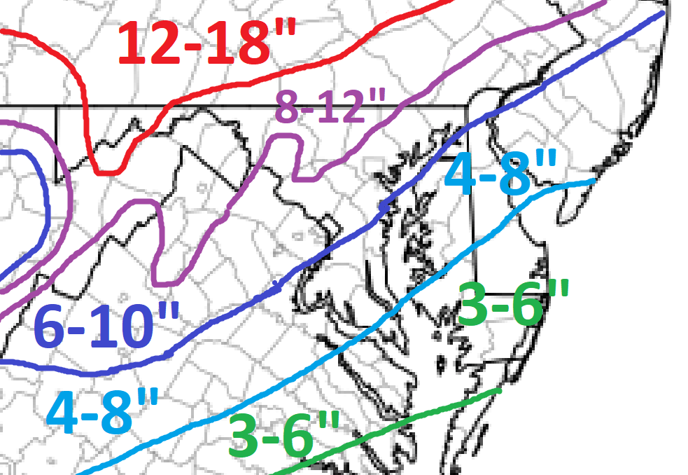
-
I definitely understand taking a step back. And I hope the health thing has been resolved! The kids are doing good, getting too big too fast. Hope all is well... maybe I'll do another BBQ this summer...it's been too long!
-
January 24-26: Miracle or Mirage JV/Banter Thread!
psuhoffman replied to SnowenOutThere's topic in Mid Atlantic
You came to the right place... you will find everyone in here is very sympathetic to the plight of Boston -
Jan 24-26 Weekend Snow and Sleetfest Model Thread Part Tres
psuhoffman replied to H2O's topic in Mid Atlantic
I think the euro improvement, when taken along with all the rest of the 12z guidance...was more than just noise. Keep in mind we are not going to see some massive jump every 6 hours from here on it, not on the euro anyways...not this close in. But the changes I see on the euro are consistent with the changes I saw across the rest of the 12z guidance, so I think even though its an incremental change...its safe to say it's not just noise. -
Jan 24-26 Weekend Snow and Sleetfest Model Thread Part Tres
psuhoffman replied to H2O's topic in Mid Atlantic
They get higher ratios, they will be fine. -
Where you been friend?
-
Jan 24-26 Weekend Snow and Sleetfest Model Thread Part Tres
psuhoffman replied to H2O's topic in Mid Atlantic
Euro was kind of the model the most "in the middle" so it makes sense it would change the least as we get convergence among the others... -
Jan 24-26 Weekend Snow and Sleetfest Model Thread Part Tres
psuhoffman replied to H2O's topic in Mid Atlantic
With the euro to go (and obviously that could change things quite a bit) this run has been the first time I saw legit improvement across the guidance and not just grasping at noise level changes. Until now I felt each run was a very slow bleed in the wrong direction but 12z was an actual improvement across everything so far imo.


