

psuhoffman
-
Posts
26,411 -
Joined
-
Last visited
Content Type
Profiles
Blogs
Forums
American Weather
Media Demo
Store
Gallery
Everything posted by psuhoffman
-
 TT shows all frozen including sleet and freezing rain as 10-1. WxBell does better at estimating snow v ice, still tends to over do accumulations along the transition zone
 -
There is southerly flow ahead of any wave. If there was cold it wouldn’t matter.
-
Cow farts
-
Ya I’m glad you said it. I was thinking it but was just gonna not say anything for fear of pitchforks. But EVERYTHING goes 100% absolutely perfect and it’s still a mixed event in DC and Baltimore and the southern 1/2 of this forum gets rain. With literally a textbook everything for a mid Atlantic snowstorm including a CP airmass!
-
You just have to know how to decode them. Here this might help… if it looks… bad = crap ok = crap meh = crap workable = crap Kinda good = crap Good = crap wow = crap amazing = crap crap =crap
-
Oh but next time it will work.
-
The euro did that at 12z also but no one noticed because it was too warm to matter.
-
The “is it ever going to snow again” discussion.
psuhoffman replied to psuhoffman's topic in Mid Atlantic
We need the cold to have enough depth to resist when waves try to push the boundary north. let me simplify this. We have always had 3 basic ways to get snow. 1) perfect track and a cold airmass 2) a wave attacking a cold airmass 3) a lucky perfect track in an otherwise crap pattern 1 and 3 have been failing lately. 1 because when we do get cold lately it’s just not cold enough. Getting a transient 3 day cold shot doesn’t help. Getting cold when the boundary barely gets south of us behind a wave doesn’t help. For scenario 1 to work we need a broad expensive cold where the boundary gets down to like southern TN to SC before the next wave starts to lift it back north. When the boundary is stalling 50 miles south of us before the wave even starts to pump a southerly flow we’re toast unless it takes a perfect thread the needle track. We want the rain snow like to start down near Atlanta as the wave just starts to get going. Now how often lately have we ever seen the boundary get that far south? Scenario 3 is failing becausese it’s been so warm that even if everything in a micro sense goes perfect it’s just too warm. We’re left with only getting snow lately from scenario 2 which is why we’re struggling. -
The “is it ever going to snow again” discussion.
psuhoffman replied to psuhoffman's topic in Mid Atlantic
But you’re saying exactly what I’m saying only you’re acting like it’s fine and I’m saying I hate it. Yes I do think CC made years like 2010 and 2014 somewhat better. But we always had anomalous 30”+ winters a couple times a decade. If 2014 was 39” instead of 33” due to CC that is not nearly enough to make it worth having to go through years and years of utter no hope shut the blinds patterns now. A few extra inches in what was always going to be a snowy season anyways affects my mood way less than the fact that the other 75% of the time is now utter garbage. I think most would gladly sacrifice 5-10” off our two good years a decade to have the normal in our aRea the other 8 years go back to 15-20” v this crap where a single digit season is the most likely outcome in those other years which makes up the vast majority of the time! -
I’m not sure you realize how bad it’s been. Baltimore needs to average 30” over the next 5 years just to get the last 10 years back to “normal” and that’s the new lower 19” normal. Forget getting back to the historical 22” normal!
-
The ridge retrogrades too far AFTER but even for the week it’s ok we just don’t see the push of cold we need. And even when it starts to retro a PV displaced like that there should mitigate some. Ya you’re pointing out the imperfections but it’s never had to be 100% perfect to snow before. If it was we would average…well like 8” which is what DC is averaging the last 7 years! We need to be able to get some snow from flawed looks. Nina historically means we don’t get a ton of snow not this. This isn’t typical Nina. We rarely get a dreg year in a Nina actually. This is not normal.
-
There is one simple problem. Look… day 7 ecmwf This should be the seeding eastern US with arctic air. Don’t anyone say a thing about the pac or puke this is a straight flow off the arctic into a broad trough. But look 4 days later… severely displaced PV and it’s just not cold enough. Despite a continued CP airmass and straight feed off the arctic the boundary is at our latitude which isn’t good enough because any wave along the boundary will push it north of us if it can only barely get your latitude between waves. ITS JUST NOT COLD ENOUGH and it has nothing to do with the pac in that case!
-
The “is it ever going to snow again” discussion.
psuhoffman replied to psuhoffman's topic in Mid Atlantic
I'll just post the data for Baltimore and you can decide for yourself. This is snowfall before Jan 1 by season and a linear prediction line showing based on the data how much snow is most likely each year. The drop is pretty evident. The raw numbers are this... Over the whole period of record Baltimore averaged 4.1" before Jan 1 BUT.... over the last 30 years its 2.6" Over the last 15 years its 2.3" Over the last 10 years its 1.1" Over the last 5 years its 0.72" That seems pretty alarming to me!!! So I guess the questions is....are you talking about right now in the very recent last 10 years or so past...then YES its almost impossible to get snow around DC and Baltimore before January. But saying that and acting like "well that's why it didn't snow in a good pattern in Dec NOT warming" doesn't jive because IMO the warming is why...because it didn't used to be hard to get snow before January. Actually it used to be way more common to get snow than not to get snow before January. Only recently has it become some herculean task to get early winter snowfall. The numbers for DC are even more extreme btw.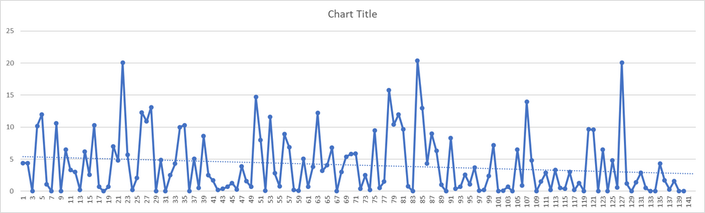
-
I can count in one hand the number of times in the last 50 years we had blocking that lasted longer than that in one run or persisted all season. Other than super rare years like 1996 and 2010 we’ve always had to rely on hitting during a 2-3 week window. And it’s not always going to come in our preferred 8 weeks of prime climo. Some good years had to work with early or late blocks. 1960 it was March. 1969 and 1970 were December. The best snow of 1987-88 was in November! Nov-Dec 89 and 90 saved those years. Snowed a lot early 02 03 and 04. Only big snow was Dec 07/08. Dec 09!!! We can’t always afford to toss everything before Jan 1 and After Mar 1 as if it doesn’t count. Plenty of years we’re decent only because of what happened early and late.
-
This is getting dangerously close to over the line but it used to be rare to get a good pattern in December but when one happened it wasn’t that hard to get snow. Even in the recent past. Nov/Dec 2002, 2003, 2005, 2007, 2009, 2010, 2012, 2013 all produced snow across our area. It never felt like it was super difficult to get it to snow if the pattern was ok. The reason snow averages are so low in Dec compared to Jan/Feb was big snows were rare early because with warmer waters I do think big wound up amplified storms are difficult to stay snow and without those 10”+ storms there is nothing to average out the 0 snow years. But getting 2-4” in December was very very common until recently.
-
The “is it ever going to snow again” discussion.
psuhoffman replied to psuhoffman's topic in Mid Atlantic
I suspect we aren’t actually far apart here just focused on different things. I know it can still snow in a good pattern with a good antecedent airmass and a good individual synoptic setup. I don’t think we’re losing big storms. A setup that would have been a mecs or hecs will probably still produce the same result Imo. A setup that would have been a cold smoke wave will still snow. We agree on that. What I’m talking about is what used to be a bad pattern that might produce 2” (or sometimes even more) from a flawed setup is now often a total shutout. We used to get a lot of small to sometimes moderate snows from a crappy pattern/airmass but a lucky fluke good synoptic setup within that larger crap pattern. Let me illustrate what I mean. One of the best examples of what I’m talking about Imo was a storm in 1997. All of North America was flooded with MP +5 or more anomaly air. But a temporary Hudson high caused a system from the SW to slide across under instead of cutting like every other wave in that pattern and we got a 3-6” snowstorm across the area. I think it was 3” at DCA and 6” at IAD. Look at that h5 for the week leading up to that snow. The airmass was garbage. It was 60 and 50 a couple days before and 40ish the day after even with snow cover. The snow fell at 32-34 degrees. What I’m saying is there is no way on gods green earth that pattern produces a 3-6” snowstorm anymore. That look now isn’t just hostile it’s a downright torch and we would by way too warm. And people would be saying “but the antecedent airmass was warm and the pattern isn’t good”. But that didn’t used to be an automatic death-knell to snow. We used to be able to get SOME snow from a bad pattern if we got lucky. That’s the best example because we remember a 6” snow. What was more common was a 1-3” slop event. And getting those in bad patterns was why Baltimore used to rarely have a single digit snow season and now they happen 50% of the time. Or why Baltimore used to have a 50/50 shot at 20” and now it’s like a 20% chance. Our good patterns are still good. But our bad patterns are now no hope shit the blinds forget about it torches!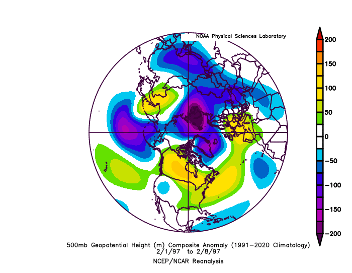
-
Other than the NAM the last 24 hours the coldest guidance (euro, Icon) has trended warmer while the warmest (Gfs) trended colder. This is convergence. Problem is even the coldest solutions aren’t cold enough for most so a compromise wont be a good end result.
-
Icon flipped from the coldest to the warmest solution in one run. Lol.
-
The “is it ever going to snow again” discussion.
psuhoffman replied to psuhoffman's topic in Mid Atlantic
Yea this isn’t the best example but on the other hand it has been possible to get some snow from a flawed marginal airmass. I saw plenty of them. Most aren’t storms we cite. Some 2.7” slop fest in an otherwise bad period isn’t something most remember usually. But they filled up our records and made a total shutout year a 8” year or a 5” year a 12” year or a 12” year a 20” year imo. There is no one example that’s proof. But I think the accumulation is. The fact we’ve had several “everything went 100% perfectly and it still was just too warm” examples recently. The Super Bowl storm in 2021 was the worst. Prime climo. Wasn’t a horrible airmass. I mean it was but it shouldn’t have been it was a mix of cp and Mp not pure pac. Storm took a perfect track. And 95 just got rain. Over the years we are consistently underperforming the analogs too. This year our top analogs to various patterns have been bad. But not total shutout bad. At various times 1985, 1998, 1954, 1991 and 2005/6 were top analogs. But the periods each of those years cited produced some snow. Nothing epic but a lot of 1-3” type snows near the analog dates. Even 98 didn’t snow in DC but it did in the area. Up here has 15” by now in 1998. IAD had like 5” by now. Yes the analogs say this year should be bad. But not this bad. What used to be low snow patterns are now no snow patterns. That’s what the analogs keep saying recently. -
No comment
-
For me I totally agree. But some are acting like this is torture. If so…just stop. Nothing will change. It will still snow or not snow. No reason to do something that has no impact if you don’t enjoy it.
-
I actually enjoy this. I like the challenge. I like the analysis. I like the banter and debates. And I like the camaraderie. Yes I would like it all more if it was snowing. But being here isn’t why it’s not snowing. If I wasn’t doing this it still wouldn’t be snowing I just wouldn’t be enjoying this discussion with you guys. So honest question/point… if you really don’t like the tracking and only want it to snow….why not just stop tracking and simply enjoy the snow when it comes?
-
Yea I see it too. I’m very confident had it gone out far enough given the setup there would have been a lot of hits.
-
18z eps is same for Sunday but a lot better as the next wave starts to get together. Way more confluence over the northeast. I really think had it gone out further it would have been a good run for next week. Not worth much but hey I’ll take it.
-
Yea ok and if the Giants beat the Eagles Saturday and some joker says “but it’s awesome if you just root for the Giants” they’re getting punched in the face.


