

psuhoffman
-
Posts
26,411 -
Joined
-
Last visited
Content Type
Profiles
Blogs
Forums
American Weather
Media Demo
Store
Gallery
Everything posted by psuhoffman
-

The “is it ever going to snow again” discussion.
psuhoffman replied to psuhoffman's topic in Mid Atlantic
This is another good one... in a nina... Pac puke pattern...extremely -PNA, very warm profile in N America. we got a 3-6" snowstorm during this pattern... 10" up here! It was warm...like 50 degrees a day before and a couple days after the snow, but it snowed because we got lucky and a feature within this otherwise horrible pattern with warmth everywhere took a perfect track and so despite a pac puke regime and a horrible longwave pattern it snowed and turned what could have been a really horrible shutout season into just a bad one. Now we just say "it can't snow in that" and dismiss it.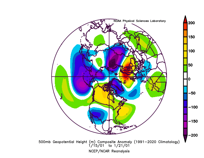
-
The “is it ever going to snow again” discussion.
psuhoffman replied to psuhoffman's topic in Mid Atlantic
Here is another example...we got 2 snows during this crap pattern... about 8" up here and about 3-5" in the cities. We would be 70 degrees in that now and everyone would be saying "of course it can't snow look at the pacific its awful with a -pan and a raging eastern ridge.
-
The “is it ever going to snow again” discussion.
psuhoffman replied to psuhoffman's topic in Mid Atlantic
I know it can still snow with a perfect track AND cold air in place. The problem is what we don't seem to be able to do is get snow out of either flawed tracks or flawed setups anymore. Those were never big snowstorms. I don't think we are losing out of MECS or HECS events really. They take everything being perfect. But I do think we are missing out on all the 1-3" or 2-4" and even some 3-6" type flawed marginal events that made up a significant portion of our snow climo in years past and are what made the non really snowy years more bearable. I wanted to give some specific examples of what I mean. Here is one I remember from an otherwise crap year 1992. I remember this little boundary wave in an otherwise horrible year. It was only like 2-3" of snow...but things like this are the difference between a complete shutout and a 5-10" season. Look at the H5 pattern the week of the snowfall. Talk about pac puke! Look at the Aleutian ridge and the vortex just off the pacific coast flooding the CONUS with pac puke. But I picked this for a specific reason. Not only is this an atrocious h5 pattern on its face, its similar to the problems we've had lately that everyone keeps using to excuse why we are torching and can't get any snow at all...it is also similar to the setup we see coming up with the TPV displaced into Canada. In this case its not as displaced as guidance projects next week. Yet the majority of runs still keep the boundary to our north most of the time. Yes we have seen some hits but still more evidence is against a snow. Yet look how far south the boundary was suppressed even in this look with that got awful pacific in 1992. Look at the bottom right panel where I highlighted the cold boundary...to our south. The snow event happened the next day, you can see the wave organizing in the plains here and a day later it slides by just to our south and gives the area some snow. Despite a horrible pacific...we snowed. Yea we didn't snow a lot that winter...it was a horrible winter by the standards of that time... but it did snow...in a pattern that now we just assume is shut the blinds. Maybe the boundary does get suppressed that much coming up...but if it doesn't I am tired of hearing how "well its just the pacific is hostile" or this or that... these kinds of flawed setups have worked in the past. So why are they NEVER working lately...its not that they should all work. Its just that some should. We shouldn't get weeks and weeks and weeks of non stop no hope torches from h5 patterns that are crappy but in years past were not total shut out patterns. Anything other than a great pattern is crap lately.
-
After the wave on the 26th we might have a window of opportunity. The TPV gets displaced under the blocking in northern Canada down to hear Hudson bay. But its not a sure thing. Actually I would still bet against us getting a significant snow from it. Because the pac jet is retracting too much and the ridge out west is pulling back off the coast with starts to try to pump a SE ridge. What makes this run, and some others work...is if the TPV spins long enough and gets displaced far enough south it suppresses the boundary far enough that one of the waves can get under us and there would be cold north of the boundary in that setup with a PV that close to us. It COULD work at least. But we still will need a lot to go right, its not a high probability, but its way better than anything we've had so far. We've scored wins with worse over the years.
-
You can't trust any specific details at that range but that is the window, AFTER the 26th Wave IF we can get a wave to ride the boundary before the pac jet retracts too much and the SE ridge pumps to kingdom come. The question is how long is that window, where does the boundary set up, and do we have an active STJ at the right time. But its the first time in a long time I think there is even a chance for us.
-
There isn't really a true high off the coast...the real high is up over Quebec and banana over the top exactly like we want it. The high to the east is really just an artifact of there having to be higher pressure to the east of the approaching wave. That's always going to be the case...but its not the problem. Your first point...there just isn't any cold in front of this wave...is the whole problem. We can pick apart these different levels and progs all we want but I could throw up a dozen examples where at H5 and H7 you could see an exact same synoptic setup and it was a 3-6" snowstorm in Baltimore, the difference was IT WAS COLDER lol.
-
yea cause this wave spacing With this confluence/flow over the top Just isn't good enough on January 25th. None of that is the problem. This is like blaming a loss on the receiver who had 9 catches for 145 yards and 2 TDs by saying...well we just needed him to have 12 catches for 200 yards and 3 touchdowns. Maybe the problem is just simple.... on January 25 with a damn perfect setup for an WAA front end thump...the boundary even right behind the last wave never makes it south of the Mason Dixon line...here it is before the southerly flow even begins from the next wave. It's game over before it even starts. Its just too warm.
-
I just heard Elvis died!
-
Yea we will see... but a few times they went into mid winter with almost nothing like this and always recover at some point. They hold snow pack up there really well...it just doesn't warm up even in a torch pattern once you get into NW Maine. Even super cutters end up mixed events up there that don't really kill the pack much. So they just need a 2-3 week period somewhere in winter where they get dumped with like 50" of snow...then they make snow and Spring skiing will be ok. My guess is they get enough snow the next month that it ends up OK. Actually...if we get a lot of snow here that's bad for them...they've had almost nothing...if the boundary ends up down here and they are dry now...then it warms up after...that would be a total disaster for them.
-
The Seasonal Snowfall Futility Markers
psuhoffman replied to North Balti Zen's topic in Mid Atlantic
-
Yea, by far my favorite east coast mountain. But I prefer it late season. Mid winter it can be icy and cold as hell and it rarely gets as much snow as Vermont. But it holds snow pack in spring amazing and so April and even May it is awesome.
-
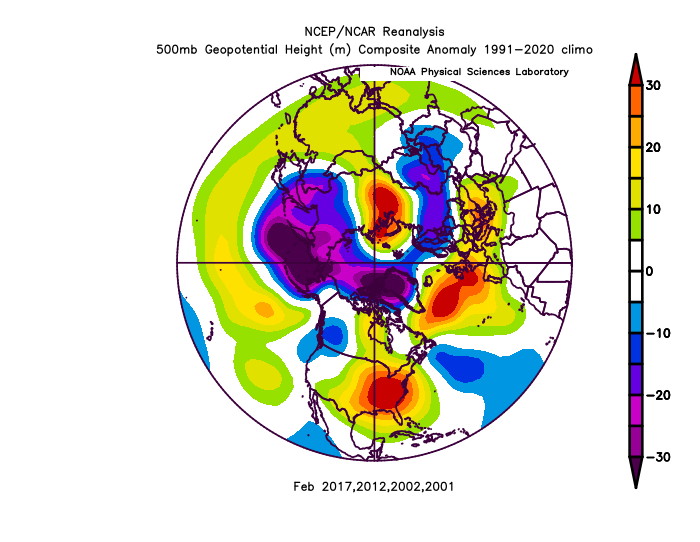
I can't believe it's come to this. I realize anyone who lives near DC and Baltimore can't relate...I know because I did live in the 95 corridor for 26 years. But up here getting no snow for periods like this is just unheard of. It's one of the reasons I moved here. That's what makes this different... a lot of the total crap years people in DC are throwing around where it didn't snow much at all to say "see this happens"...it was at least snowing some up here. Not a lot...but some. Even the dreg years people cite like 2020, 2012, 2002, 1998... up here had over 10" of snow in every single one of those seasons by now!
-
The “is it ever going to snow again” discussion.
psuhoffman replied to psuhoffman's topic in Mid Atlantic
no -
It helps me that April has spring break to plan, and I love spring skiing season in New England so often I am occupied planning multiple weekend trips up to Sugarbush or Sugarloaf to get some last turns in. April skiing up there can be awesome.
-
I haven't given up on salvaging some snow this winter. I do think we might get an opportunity next week. A week of straight flow off the arctic will establish a colder regime. But as I said yesterday its still disappointing that even with runs that have a severely displaced PV in a really good location with a week of straight polar flow...it still seems like the boundary want's to set up pretty far north. The cold just isn't that impressive given the longwave pattern and not expansive enough for our latitude on the majority of runs. But its close enough that it wouldn't shock me if we get a wave to work in that period. After that it's probably back to torch no hope for a while. We have so much working against us in Feb. The MJO is heading towards hostile territory. And while the good phases have not helped us much recently...the warm phases always seem to kill us. Its a negative correlation only. Nina feb climo in a +QBO is pretty god awful. I know some are referencing the dying nina but if you look at years with a fading weak nina heading towards neutral in Feb the climo isn't any better. Almost everytime we have a nina that might fade I see this "its fading by late winter" being tossed around but frankly there is absolutely no data or objective evidence suggesting a fading nina to neutral during winter is good. The Feb/Mar analogs are actually WORSE. Sometimes they turn around in March, almost never in Feb, but actually slightly MORE nina's that were strong all winter had a March turn around than the weakening ones. That is because some of the nina tropical forcing that is awful during early and mid winter actually becomes somewhat favorable in March. Here are the Feb analogs to a weakening Nina heading to neutral enso over the last 30 years. March is a wild card. Is the PV takes a hit it does increase chances for blocking and in March blocking still seems to be impactful. It seems early in the season to even mid season blocking just doesn't have much impact anymore, at least not enough to bully other factors anymore...but Feb and Mar it still can. So if we can get blocking in March maybe we salvage a period of opportunity. Similar to 2018.
-
I can relate... yes I like snow whenever and I will track anything anytime, BUT... getting snow in March in an otherwise awful season is kinda like when your favorite team wins a game in an otherwise crappy season. Yea you can enjoy that one game and cheer when they score...but at the end of the season it won't change how you feel about it as a whole very much.
-
our winter is having technical difficulties. It failed to boot properly. We're stuck on the circle of death
-
The only way that technique would work this year is if you have a snowmaking attachment on your lawn mower.
-
I hope everyone knows I'm mostly just trying to have some fun and make light of this situation. It is awful, but it's not actually ruining my life. I'm just being a smart arse about it. But... how March changes my perception of this winter would totally depend on how good March is and what happens in the next 2 weeks. Either way I would enjoy the hell out of any snow. My 4 year old daughter literally cried last night. She got a unicorn sled for xmas, it was the thing she wanted most...and its sitting totally unused in the corner behind the tree. Yes the tree is still up because my kids don't want to take it down and what do I care I'm grown I can do what I want! Do you know how unprecedented it is to not have at least one sledable event here by now? So for her sake especially I will savor any snow we get. But for me...unless we get something out of what I do think is a decent, not good but decent, window next week, one storm in March wouldn't really do much of anything to change my perception of this awful train wreck of a season. If we get a snow or two next week...then a couple snow events in March...yea it would move this season up out of the total dreg 2002, 2012, 2020 category into the simply run of the mill bad category. Of course if we got some kind of 1960 epic run that included a HECS and 3 weeks of snowcover then of course it becomes a late save good year. But what are the odds of that lol. For me what makes a winter is actually not the final total. And it's not really even a big event. This is hard to articulate clearly but its...was there a decent stretch at some point in the winter with snow cover and cold. It doesn't have to be 20" of snowcover. I was pretty happy with 2018 for example even though it was below avg snowfall here because we had a nice December storm, it wasn't a lot of snow but so cold the snow we got in late Dec and early Jan was on the ground for a while, and the March storm snow cover lasted like 7 days even in March. So at the end I felt satisfied. I got my "feels and looks like winter" fill. On the other hand 2012/13 had identical snowfall totals here but it felt awful because every snow melted the next day and was spread out so there was no period that felt or looked like winter all season.
-
You know I'm just kidding
-
Thanks for clearing that up. I thought the fact there were no posts in 8 hours was a good sign.
-
No idea why, the pattern change is only 40 days away.
-
To be fair anyone in the profession knows what they’re looking at and would never use those TT snow maps.
-
Ya it might matter but it’s still noise when the rain snow line moves 7 miles lol. It’s random error not necessarily a trend. It’s also hard to compare bevstaw 12z dropped like 1-2” on northern areas with that late development and 18z ends before we see that part. But comparing up until then they are close in terms of where the snow is. 18z upped totals an inch or two in some banding. I saw nothing that looked like a real significant change.
-
Noise


