

psuhoffman
-
Posts
26,411 -
Joined
-
Last visited
Content Type
Profiles
Blogs
Forums
American Weather
Media Demo
Store
Gallery
Everything posted by psuhoffman
-
Lol we talk like we live in northern Alabama or something
-

January/February Mid/Long Range Disco IV: A New Hope
psuhoffman replied to stormtracker's topic in Mid Atlantic
It didn’t have to wait long. Here mid day Feb 1 the front hasn’t even cleared yet. That night early morning Feb 2 the cold has just arrived behind the wave And 48 hours later it’s been totally obliterated without there even being a cutter simply from very ordinary return southerly flow So what’s the window here? I keep seeing this sane general theme, if the cold gets routed that easily were left praying for a perfect timing thread the needle solution. Don’t get me wrong it could happen and it’s a better threat than we’ve had, but I hope ppl aren’t confusing that with a legit good high probability threat. This setup still seems more likely to fail than succeed imo -
January/February Mid/Long Range Disco IV: A New Hope
psuhoffman replied to stormtracker's topic in Mid Atlantic
This is correct in that we have had a couple blocks recently where there was no response in the mid latitude Atlantic under it. That’s troubling. But what’s more troubling are these 2 recent blocking episodes where we did get the 50/50 and it still made no difference. and yea the pac wasn’t good…but back to my point about the pdo, if that’s going to be the pac base state 80% of the time for the foreseeable future we can’t afford to just say “the pac”. We have to look at how we overcame that look in the past. What troubles me in the last 4 times we got blocking recently…it didn’t work! I am in the process of compiling data to see what the % of times we got snow in a -NAO -PDO month during the last -pdo cycle and see what the success rate was to see if our recent -NAO fails are typical or a red flag. But I have to do some real work so I’ll get to that later. -
@HighStakes any idea what’s going on in Manchester?
-
January/February Mid/Long Range Disco IV: A New Hope
psuhoffman replied to stormtracker's topic in Mid Atlantic
This is the H5 composite for Dec-Mar for the entire 1960s. Looks like the dominant features were the -NAO but also an atrocious PAC with a dominant Aleutian ridge -PNA. But the obvious, even if you adjust for the fact that is using today's climo which skews everything towards the blue...is the fact the mid latitudes were simply colder everywhere. Here are the snowiest periods of the period March 1960 Dec 1961 Feb to Mar 1962 Jan to Mar 1964 Jan 1966 Look at the pacific on all those!!! But it wasn't just the 60s. There wasn't nearly as much snow in the 50's and 70's because the NAO was predominantly positive...but if we look at the snowy periods during those periods we see the same thing...the NAO overcoming the pacific. 1979 Yes there were some exceptions where we got the PDO to go temporarily positive like 1961 or 1978 and those were good years also... but the PDO was negative 80% of the time from 1945 to 1981 and yet we still managed to average significantly more snow during that period than we have since when the PDO averaged positive 72% of the time. I have some thoughts on possible reasons "why", some AGW and some not, but perhaps we should continue that over in the other thread to avoid the shitstorm that would result here... but this is why I keep harping on the idea WE HAVE TO BE ABLE TO SNOW IN FLAWED PAC PATTERNS. Look at the pac during those snowy periods above. If we are in fact entering a long term -PDO cycle THAT IS HOW IT HAS TO SNOW!!! The pac is probably very rarely going to look the way it did most of the more recent past with some huge epo/pna ridge. That was almost NEVER the winter base state during the last -PDO period. But that is not a valid excuse for no snow because we got plenty of snow in the last -PDO, we just had to overcome the awful pac pattern with other factors. -
January/February Mid/Long Range Disco IV: A New Hope
psuhoffman replied to stormtracker's topic in Mid Atlantic
because that's when it snowed -
January/February Mid/Long Range Disco IV: A New Hope
psuhoffman replied to stormtracker's topic in Mid Atlantic
0z looked better than 6z but slightly worse than yesterdays 12z. Maybe it’s a bounce but it’s bouncing subtly the same direction everything else has, the wrong way. Look I hope you’re right and this is different. I’m just skeptical. -
January/February Mid/Long Range Disco IV: A New Hope
psuhoffman replied to stormtracker's topic in Mid Atlantic
That threat was. But before that we were looking at the Feb 1 wave and before that the Jan 28 wave and before that Jan 25 was the one. For the last month every wave looked good day 10-15 then trended to the same garbage by day 7. Some because the track. Some took a perfect track and we’re just too warm. But it’s been the same dance for weeks. Now eventually one of these will break through and become a real threat. I mean I hope so otherwise we will never snow again lol. But given the constant head fakes all season I’ll continue to be skeptical until it’s inside day 7. -
January/February Mid/Long Range Disco IV: A New Hope
psuhoffman replied to stormtracker's topic in Mid Atlantic
I want this to be “real” as much as anyone. But as the “window” starts to broach day 10 I see the same trends with every other threat period all year. 24 hour trend on gefs for the 7 day snowfall centered on our period of interest. Hopefully today we bounce back. -
January/February Mid/Long Range Disco IV: A New Hope
psuhoffman replied to stormtracker's topic in Mid Atlantic
I made a really long post about this in my “other” thread yesterday but this is totally about a cyclical pattern not AGW so I’m repeating the cliffs notes version here and y’all can deal with it. It seems we’ve transitioned into a -PDO regime. The last long term -PDO was from 1945-1981. If true we can expect the pna to be “hostile” the vast majority of the time the next 30-40 years. If you look back at 1945-1981 the way we overcame that was mostly one thing. Blocking blocking blocking. A -NAO would suppress the attempted SER and lead to a broad mid latitude trough coast to coast under the block. Here is the h5 for 6” snows at bwi during that period. Keep in mind that uses 1990-2020 climo so the blue is exaggerated due to todays warmer normals. but you can see the longwave pattern. Note there the pna is still negative but not crazy negative. The path to snow during our last -pdo was to time up less hostile pac periods with a -NAO. The problem is our last 4 blocks failed totally for the same reason, it just wasn’t cold enough. That has nothing to do with the pac. It’s rare to get a NAO block AND a big epo ridge. Those 2 have a negative correlation. A -NAO was how we overcame a bad pac from 1945-1981 so when we get blockinF fails and ppl say “but the pac” I roll my eyes because the pac is going to be utter garbage the next 35 years, the NAO is supposed to be how we offset it. The positive NAO periods during the last -pdo cycle were awful by that periods standards. But the -NAO periods were very snowy DESPITE the pacific. -
January/February Mid/Long Range Disco IV: A New Hope
psuhoffman replied to stormtracker's topic in Mid Atlantic
I hate to try to translate his “stuff” but if what he really means is we would be better off given the Nina/TNH base state if we got a TPV displaced into eastern Canada along with a +PNA (remember he is also predicting a +pna, ironically since guidance is now hinting maybe…) he is right. It’s not the greatest pattern but a “south biased” +NAO in conjunction with a pna ridge is better than anything else if we accept the N Amer thermals will struggle AND a SE ridge will try like hell no matter what. In that reality a Tpv over is suppressed the SE ridge and provides a cold source and the pna gives us a shot to keep waves under us. But the pna is the key. If the NAO goes positive and the pna stays negative we’re royally fucked. -
January/February Mid/Long Range Disco IV: A New Hope
psuhoffman replied to stormtracker's topic in Mid Atlantic
Guidance has seasonal tendencies. They used to be more consistent. For years the GFS was too cold and would adjust north like clockwork. The euro would cut off too often and leave energy behind. But now with constant updates these biases change year to year. But this season guidance has made 2 key errors at day 10+. Underestimated the SE ridge and overestimated TPV displacements. Those 2 continuous adjustments take a pretty good day 10 look and turn it into garbage for us by day 5. -
January/February Mid/Long Range Disco IV: A New Hope
psuhoffman replied to stormtracker's topic in Mid Atlantic
This tells the story -
The “is it ever going to snow again” discussion.
psuhoffman replied to psuhoffman's topic in Mid Atlantic
Do you really think “everything’s fine” or are you just trying to prevent negativity? If it’s the layer I can respect that. I do. But if it’s the former…I used to be on the side you seem to be here but that was years ago when we were in a drought that was historically sucky but normal and wasn’t nearly this bad. We’ve now entered totally unprecedented levels of suckage both on seasonal (many regional locations are close to or already have set records for latest without snow) and longer term (least snow last 7 years) levels. But you’re talking like this is just normal par for the course. Maybe on the eastern shore sure…but further NW it’s unheard of to be this snowless for long stretches year after year like this. It’s sad that many use last year as some high bar when really it was just a lucky fluke some places in here ended up near median. Look at the snow anomalies for last winter. That tiny little area that just happens to run through our general area of near normal is surrounded by 500 miles of below in all directions. It’s just an artifact of crazy good luck in one event in a location where avg snowfall is so low that can skew results. Last year was another crap year where 90% of the mid Atlantic struggled just like the last several. Some local places just got really lucky. -
January/February Mid/Long Range Disco IV: A New Hope
psuhoffman replied to stormtracker's topic in Mid Atlantic
This isn’t normal for a Nina. BWIs avg snow through Jan 31 in a Nina is 10.3”. Never been shutout. Manchesters avg is 18.4”. Least is 6.4”. Nina’s have less variance. They are rarely good but rarely really awful either. But I’ve been trying in this thread lately. Pointing out ways we “could” get something even if I don’t really buy it. But this gets old…look at Jan 28 4 days ago and now. now the cold comes Feb 2-3 ok. Let’s see what it says in 3 days…. -
January/February Mid/Long Range Disco IV: A New Hope
psuhoffman replied to stormtracker's topic in Mid Atlantic
Winter is just a shitty period now -
January/February Mid/Long Range Disco IV: A New Hope
psuhoffman replied to stormtracker's topic in Mid Atlantic
Lol I’ve been trying so hard the last couple days not to poop in this thread but I’ve been getting a chuckle thinking how since Xmas it been “ by Jan 10” then Jan 15 and 20 and 25 then 28th then Feb 1 now Feb 6. The same look has been stuck at day 10-15 for a month now. -
1/23: 1.7” total: I feel like this row is just mocking me
-
The “is it ever going to snow again” discussion.
psuhoffman replied to psuhoffman's topic in Mid Atlantic
No one can say the future. But why don't you simply use objective evidence about the recent past to make your determinations. Frankly even before this recent god awful run you were unhappy most of the time. So even in our best of times our climo wasn't really good enough to satisfy you. If snow is as important to your mental health as it seems to be...you really should move. If you cannot change your attachment to snow and you continue to live in a place it doesn't snow much you will continue to be miserable most of the time. -
The “is it ever going to snow again” discussion.
psuhoffman replied to psuhoffman's topic in Mid Atlantic
We can't know yet. I am not sure how much of this is AGW. There might be other cyclical things going on, I suspect there are, but again what does it matter? Lets say for a second that the Indo-Pac warm pool is NOT related to AGW, and its some long term hundreds of years cycle that we just don't know about because we don't have records going back far enough to capture it... and lets say the same about the expanding Pac Hadley cell. We know the PDO is a cyclical 30-40 year cycle so then add in that. So lets say this new horrible snow climo is a result of mostly 3 factors that are not related to AGW...that doesn't make my arguments or fears any less correct, that our snow climo has severely degraded. I have never made this about AGW. I accept the reality that it is getting warmer, thermometers and all that jazz, but I have not made this a AGW or man has made us not snow anymore thing. I am simply focused on why are we in the absolute worst stretch of snowfall in the history of records in our area. What is the cause. Maybe its AGW. Maybe its all cyclical. Maybe its a combo. Whatever. But the reality is its snowing less now than in any previous period of record...and its starting to become a long enough period of time its getting harder to dismiss as just a temporary thing. I don't mean temporary as in FOREVER but temporary as in its likely to just flip all the way back to historical norms very soon. -
The “is it ever going to snow again” discussion.
psuhoffman replied to psuhoffman's topic in Mid Atlantic
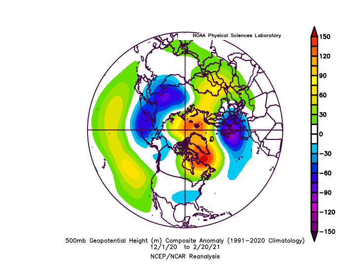
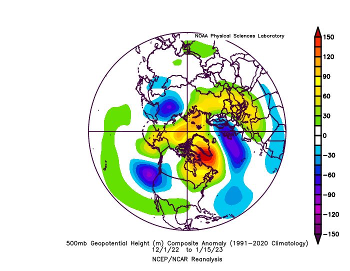
Don't get me wrong...its a better pattern simply because there is enough cold around. But it's not actually a "historically snowy" looking pattern. I think that because recently we have failed completely due to temps people have begun looking for "cold" as if that means "snowy". But historically those are very different things. Until recently we failed due to dry just as often as warm. There are plenty of "cold" periods that had little to no snow through history. I don't think we are necessarily more likely to snow just because its cold now...its just warm so damn much of the time that warm has become the bigger problem. But rooting for a cold/dry pattern or more accurately a "colder" pattern but one that is likely to warm up before any storm...isn't really the answer. @CAPE I agree that we need cold to snow...I mean that's not a revelation. So doing something to get a colder profile is necessary. If we are to accept to get cold enough to snow we NEED an EPO induced arctic airmass then yes I guess we must root for that first. But there is a reason the EPO has absolutely no correlation to our snow. It's because through history we have been able to snow without needing EPO induced arctic air. In short if it's true we can't get cold enough without an arctic airmass anymore were fucked. Because that means you're now stacking one more variable on top of what we already needed to get snow, which even before was anomalous, we were never a very snowy climate. And on top of that, the variable you are stacking is one that actually correlates to a very bad longwave configuration to get a favorable storm track. A big EPO ridge is actually NOT the right jet configuration to get an east coast snowstorm. So now...the implication is we first need a big EPO ridge, then let the cold get into the CONUS...then we need to root for a pattern change AFTER that to the right longwave jet configuration right after the EPO and before the cold gets obliterated by the pac again. Ya ok...if that's true then that right there is why its never snowing anymore in general the last 7 years. lol The reason many are rooting for this upcoming pattern IMO is simply because patterns that SHOULD SNOW have been failing lately. We are in a predominant -PDO pattern. If you look back at the last -PDO period from 1945 to 1980 the way we got snow was mostly through a -NAO overcoming the -PNA. Look at a comp I put together of Baltimore 6" snowstorms during the last -PDO period with a -PNA. This is the look we want. The most obvious feature there is the west based blocking which causes the mid latitude response necessary to overcome the -PNA. No the NAO wont stop a -PNA in a -PDO regime. But in the past what a -NAO did was cause a full latitude trough across the mid latitudes UNDER the blocking so the PNA didn't matter so much. But lately that has been failing. Look at the last few -NAO periods... 3 of the last 4 NAO blocks instead of forcing a trough under the SE ridge linked up and created a full latitude ridge instead. That is NOT the typical response during a -PNA/PDO regime. If that was true it would have never snowed from 1945-1980. The other, the winter of 2021 was the most egregious and most alarming. Look at that H5 for the winter. Keep in mind the composite I showed from earlier snows was using current climo skewing the means. There was a colder base state then so that 2021 mean is almost identical if you adjust for that. The ridges and troughs are in the same spots. But it didnt do DC and Baltimore any good. It was simply too warm. We had like 6 perfect track storms that winter and it was just mostly rain everytime along 95. It was barely cold enough to be snow up here! Even this winter's pattern so far is closer to what historically is a "snowy" look than the one coming up. Again... That right there is NOT a shut out shit the blinds no hope torch look. If you showed us that back in October and said that would be the pattern from Dec 1 to Jan 15 I would not have said uh oh were in deep trouble. That is a decent look. But we were torching so everyone is acting like its been a bad pattern and we need something else...but the coming "colder' EPO pattern is actually historically a lower odds of snow look than the one we just have had. The fact it was too warm in what should have been a decent pattern doesn't mean a cold but historically bad for snow one is more likely to be any better. It might be slightly better ONLY because the better pattern turned out to be a torch but a -EPO +NAO is NEVER going to bring us to the holy land of a truly snowy period. The best we will ever do is what we have been doing the last 7 years which is luck our way to table scraps once every LOOOONG while if we can't snow from blocking without arctic air anymore. @WxUSAF You brought up the PDO the other day so I did some numbers. And this is scary. The last -PDO lasted from 1945 to 1980 where the PDO was negative 80% of the time during winter. Then from 1981 to 2019 the PDO was + 73% of the time during winter. If we have just entered another -PDO cycle its likely to last the rest of our lives. But looking back at 1945-1980 we were able to overcome it much of the time. But I found some scary numbers to indicate things might have been degrading much earlier than we knew but the +PDO was covering it up. From 1945-1980 we had 29 seasons with a predominant -PDO during which 52% still featured a 6" snow day at BWI. In other words more than half the time we were able to overcome the unfavorable pacific and still get at least one big snowstorm. But from 1980 to 2019 we had 12 seasons with a predominant -PDO and in all those years there were just 2 6" snow days at BWI. So we only were able to get a big snowstorm 17% of the time since 1980 during a -PDO while before 1980 we got a big snowstorm 52% of the time during a -PDO. So....was our climo degrading much earlier than we even knew its just the favorable PDO was covering it up for a time? If we can only get a snowstorm 17% of the time in a -PDO and we are heading into a LONG period where we will be in a -PDO 80% of the time...that math is REALLY UGLY.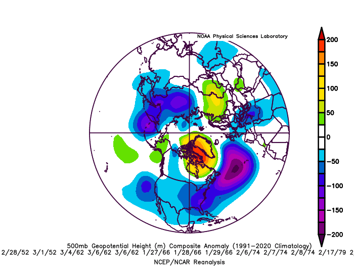
-
January/February Mid/Long Range Disco IV: A New Hope
psuhoffman replied to stormtracker's topic in Mid Atlantic
We obviously just need a 1060 high! My book is full so fuck it. -
January/February Mid/Long Range Disco IV: A New Hope
psuhoffman replied to stormtracker's topic in Mid Atlantic
My “gloom” was analysis of what happens after. Feb 1-5 or so holds some potential. But it looks like it deteriorates into another crap pattern pretty quick. That gives us 1-2 wave opportunities perhaps. You know how our luck seems to go with any one wave. And the pattern is good not great. Usually to hit with a one and done we need a REALLY good window. I was hopeful to get either a better short term window (some blocking perhaps) or a longer lived favorable window at some point. We very much can score a hit in the Feb 1-5 period. But if we don’t it could get real ugly. That’s where I was coming from. -
The “is it ever going to snow again” discussion.
psuhoffman replied to psuhoffman's topic in Mid Atlantic
That only shows half the story...if you also show the decreasing probabilities for 20" on the "high end" of the range you start to see that there is definitely a trend from 100 years ago. Now your point that we don't know what might have happened BEFORE about 150 years ago, although we have enough colonial period accounts to say even without daily records that snowfall was probably pretty high through the 1700s and 1800s in our area, but yea before that we know about nothing. We can say based on what we know from Europe there was likely a warm period before that. It is very possible that if you want to judge things on like a 1000 time period, or even the whole period since the last ice age we were in a colder period and this warmer isn't that unusually on a very long timescale. But isn't all that irrelevant? We don't live on that kind of timescale. Humans lifespan dictates how we judge norms. This is true of everything. No one cares what prices were 100 years ago that no longer the "norm". No one cares that human life expectancy was like 30 for most of history...that isn't what we expect now. Even if we had records that went back 1000 years our expectations would probably still be set based on more recent records not what happened in 1450. No one is alive who set their expectations based on that weather. My main point is much of our pattern analysis and expectation wrt snowfall is based on the norms of the last 100 years. When we see some "look" on the day 15 ensembles and our experts opine about the snowfall potential, that is based on how that same look produced results in the recent past. So if that is changing it is very pertinent. It doesn't matter what was happening 500 years ago since that isn't what our expectations are based on. -
January/February Mid/Long Range Disco IV: A New Hope
psuhoffman replied to stormtracker's topic in Mid Atlantic
Yea I don't agree with the "rosy" assessment of that day 15 look. First of all its a long range mean...if the anomalies end up where they are...as the outliers fall off the SE ridge and associated warmth will become even more extreme. We've seen this over and over and over and over and over again. Additionally, not all "near normal" anomalies are the same. If this was a blocking pattern I would be thrilled to see neutral anomalies. But in a pattern where the cold is centered to our north and there is a hostile Atlantic, we actually need to see the cold boundary well to our south. Because any wave will push the boundary north. In general in that pattern precipitation events will likely happen and the warmest point of the pattern. So a smoothed temperature mean at that range where timing differences on waves from each run of an ensemble will vary....we need to see the boundary well south...otherwise what we are seeing is that we might get chilly for a day or two behind waves...but will likely warm up before the next. I think that day 15 look is pretty much garbage. The best thing I can say about it is its day 15 and will likely be wrong in some way...just pray it changes in a better direction not worse, because that look there is unlikely to produce a snowstorm here imo. I still agree with most that our best window looks to be in early Feb for a short period. Unfortunately its pretty much just a transition not a long lasting pattern so we likely get 1-2 wave chances then its back to shit the blinds. As the TPV gets displaced it sets up a relatively short window of opportunity where the SER could be suppressed enough. What we REALLY need is for the waves on the front end of that process to come across in pieces and not amplified. Our best shot is likely as the cold boundary presses if we can get some waves along it. If the cold blasts through behind an amplified phased wave we are likely toast as it will suppress everything and then our only hope is to pray we get a weak wave on the backside of the cold. It would have to be weak though since by the time the TPV is exiting east we resume a pretty awful longwave pattern and anything even slightly amplified will just cut way west again.


