

psuhoffman
-
Posts
26,411 -
Joined
-
Last visited
Content Type
Profiles
Blogs
Forums
American Weather
Media Demo
Store
Gallery
Everything posted by psuhoffman
-
Another concern I have revolves around where we are in the snowfall cycles. There is a lot of variability and random chaos within our snowfall climo. That is because historically we can fluke our way to a single storm even in a bad pattern. A good pattern doesn't always produce. There is some randomness to getting a good or bad pattern in any cycle. But within that seasonal and decadal variability is a clear trend where we get better cycles for snowfall and worse. My fear is that our snowfall decline has been worse than we knew because it was being masked by what was actually a "snowy" cycle from 2000-2015. Let me illustrate what I mean... the late 40's to late 50's was a bad longwave base state for snowfall here and prior to this current period was probably the worst long term era for snowfall in our area. This was actually the most comparable pacific cycle to the one we are in now, so not surprising we had low snowfall during that era also. But keep this look in mind later when we see the current pattern. The next cycle 1958-1971 was our snowiest period since the 1800s mostly driven by a consistent -NAO. Which was followed by a shorter cycle of a hostile pacific without NAO help in the 70s that was pretty bad for snowfall...This was another period compared to the current one. Again it was bad for much of the same reasons WRT the pacific but keep this look in mind when we compare to our current period later Which was followed by again a more favorable snowfall period from 1977 to 1988. But... look at the pattern...and look at our results. That base state pattern from 1977 to 1988 was actually BETTER than the one in the 60's but with much lower snowfall results. It could be argued our snowfall decline began to accelerate during this period...but was being masked by the fact we were in a generally good pattern which allowed for some big seasons and enough snow to mask that it should have been BETTER. We then entered the next really awful period of snowfall from 1989 to 1999. With the exception of 1996 this was a brutal stretch of snowfall winters and the pattern below justifies that. Mean +NAO and -PNA. This should have been an awful snowfall period based on the pattern so there is nothing to really take from this other than it was just a bad base state cycle. But look at 2000 to 2015. This should have been a GREAT snowfall period again in line with the 1960s. But again it was muted. Yea we did better than from 1989 to 1999 and better than we have done since...but while places further to our north like NYC and Boston were getting absolutely berried with snowfall way above their normal during these 15 years...we were basically just averaging...about avg. This should have been a HUGE red flag...that places north of us were getting record snowfall during this cycle and yet we were unable to really take advantage and were just too far south and warm to get similar results. I don't mean we should have had the same snowfall as NYC or Boston...but the same ratios. If they were 150% of normal during this period we should have been 150% also. It should have been a huge warning that they were 150% of normal and we were only able to pretty much be avg during a period that should have been extremely snowy given the pattern above. Now... look at 2016 to 2023 There are a couple take aways here. First the longwave pattern is again hostile. This would be a down period in any era. BUT...this is NOT as bad as the 50's or 70's or 90s. We have had a -AO over this period. That should have mitigated some of the hostile pac. Those other awful periods had both a hostile PAC and a hostile AO. Yet this period has been significantly less snowy than those other hostile cycles. WHY? There is one very obvious difference. I mean come on.... this is not about climate change. This has already happened. Look at all the red! Its just so much warmer. Look how little blue there is ANYWHERE! Now go back and look at all those eras I posted...and look at the trend in the blue/red. It's got warmer over each era if you take the whole northern hemisphere as a whole. This is ridiculously obvious. But the super nino in 2016 sent this trend into hyperdrive. It created a new significantly warmer base state for the cycle we have been in since. This is not political or controversial...yes we are in a down cycle, yes this would be a low snowfall period no matter what era we were in with this pattern...but the reason this period has been so much worse than previous bad cycles is its so much warmer so we don't get as many fluke lucky snows in bad patters anymore because a bad pattern is warmer...and just too warm to get snow no matter what the storm track is. But IMO the acceleration of the downward trend in our snowfall actually has been going on for a while but was masked by the fact we were in an incredibly snowy period in terms of the longwave pattern which was hiding the fact our snowfall was decreasing. Now what I don't know is whether this trend reverses itself at all. Does the effect of the last super nino wane at some point and was this a warmer period within the longer term warming. But everyone seems to be rooting for another nino...great...and yea that probably would help our chances of snow in that given season...but there is a chance we are rooting for something that will make the majority of our seasons when we arent in a perfect pattern even worse by again accelerating the warming trend on a larger scale. But now we are getting into predictive discussions and everything I have posted above is NOT predictive it is simply pointing out what has already happened and how we got to where we are now.
-
The base state longwave pattern this winter was hostile for us. This would have been a below avg snowfall winter here in any era. But I think getting really awful almost no snow winters is going to become more common. Actually it already has, thanks @North Balti Zen for the data above. There was nothing that uncommon about the general pattern this year. We have had numerous years with a similarly hostile longwave pattern in the past. And most of those years we managed to fight our way to 8" or 10" or something in that ballpark across most of the area. We had some variability. We had a period in December and March with a workable pattern. We also got some perfect track storms during a bad pattern that in the past we could luck into some snow even in a bad pattern. But lately...decent patterns that only last a week or two don't often work out. Part of that is it seems our "hit" ratio on threats even in better patterns is lower lately. Another part of that is it gets so freaking warm across N America when we are in a bad pattern...that we often waste most of a better pattern just getting it colder...and by the time we get cold air the pattern is breaking down. ANd it is so warm in bad patterns that trying to luck our way to a fluke snow is almost impossible. That wasn't always the case. Unfortunately I think this is likely to remain the normal. We will still have good seasons. There will be years where the longwave pattern is good and promotes cold air directed into the eastern US and we will get snow. But the bad years are likely to be REALLY bad. To put it simply...bad patterns are now just so warm that its almost impossible to get snow during a hostile pattern anymore, that means years that might have been 8" or 12" from some fluke hits during a year with a hostile base state overall...are more likely to end up like 2020 and 2023 where we get almost no snow at all. Getting a ton of snow in a year with a good longwave configuration won't disprove this theory...we are focused on getting a test case for "can it snow a LOT in a good year anymore" and I too am interested in that...but since a lot of our seasons are not going to be those good years...I would like to see evidence we can fight our way to a respectable snowfall in a more hostile pattern by hitting on marginal temp events and flawed setup storms...unfortunately I fear that is a lost cause.
-
It has been chilly...DC just had like 6 straight day's below avg temps...its just too late for it to matter wrt snow.
-
careful, apparently pointing this ridiculously obvious fact out is controversial and political
-
Is it possible the location is just off...and that is the closest town of note to the actual report?
-
20 was enso neutral. 09 and 12 were la nina's. Your area really got hosed in both. 09 had some cold periods in January and late feb early march...but your area missed all the snows. There were a couple of minor events in Jan that skipped over your area and the big coastal that gave the DC area 6-12" totally missed you. I got about 6" here from that and I was on the NW fringe of the snow. 2012 also probably hosed you because almost all my snow came from a couple of clipper type storms that probably jumped over you...often those don't do much in the shenandoah valley if they are on a NW to SE trajectory because of the downslope. And there was a big snowstorm in late October I got 8" from here that missed your area.
-
It’s got no room to amplify
-
Just to clarify I never said Nina’s are ok compared to ninos. I said they have been better than neutrals over the last 30 years and that’s true based on the data. I also said Ninas are rarely total dreg years like this. And that’s also true. While Nina’s are often frustrating because often that are chilly but their NS dominance means the big snows are often just put it our reach…they are rarely like this year. 1996, 1999, 2000, 2001, 2006, 2008, 2009, 2011, 2012, 2018, 2021, 2022, 2023. Only 2012 and 2023 were total wall to wall crap out of that large sample size. And for me none were close, I got about 20” in 2012. My point wasnt Nina’s are good…but they are better than neutrals and not usually awful like this. Ninos are by far the best
-
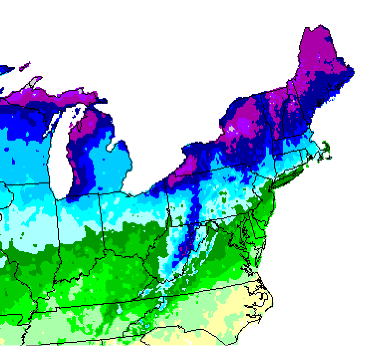
This is one of the best snowfall avg maps I've ever seen produced. If you look close you can see the snow max in northern MD that is my area. It's a little dated now...I think about 15 years old...but they used satellite data and computer simulations along with records to create a more detailed geographically accurate map than almost any others I've seen. The site that produced it and the key is long gone but I have the maps saved. You can still find them floating around random sites online too. Shame, they used to have a bunch of maps like first and last snow, days of snowcover, 10" snows...but most of them are gone. I had them all saved years ago but lost them.
-
That would be correct if they used a 10 year avg lol
-
I am higher up and 2 miles north from town but I don't think the snowfall difference is that significant. Not sure where you got that from. I know my average going into this season for the years I have lived here is 41". If you add in coop data from a station a few miles down the road and 200 feet lower (that does tend to get slightly less snow than I do) the 30 year running average was 39". Westminster MD has reliable records that go back about 100 years and their avg is about 36" with a 30 year avg of 34" and I get quite a bit more snow than Westminster.
-
I think he has a valid point though because this relates to our prospects in the future...we are in the middle of an extremely favorable period of pacific forcing and its having almost no effect on the problem out west. I think his "what's it gonna take" wasnt focused on just right now.
-
Pre Text: Some of this is a discussion with you and some is an in general response to stuff I've read over the last several years. I trust you as a knowledgeable poster to be able to tell which is which lol Yes the pac has been bad most of the last 7 years and yea that accounts for a lot of our snow troubles. I really think many are focusing on the wrong thing at times. But I am not always good at articulating it. Way too often people see a trough west ridge east and say "the pac is bad" but that is way too simplistic. Is that configuration a result of hostile pacific forcing or something else? Yes we have had hostile pacific tropical forcing much of the last 7 years. We have been in a bad cycle in that regards. So it's very easy to get lazy and just attribute all of our problems to that. But at the same time we have done worse the last 7 years than in previous similar comparable periods of hostile pac forcing. As a matter of fact we have had the least snowy 7 year period in recorded history. (please save me the argument that at some point 900 years ago it might have been less snowy I don't care) The fact is the reason this period has been even worse than other hostile -PDO periods is that we have underperformed even when the pacific forcing wasn't extremely hostile. One of the hallmarks of those fails have been 2 problems...the SER/WAR combo and warm temps in general. Often those 2 are directly related...at times the warmer boundary temps was unrelated. The warmer boundary temps are what they are and most of us know why so lets leave that alone for now. But what about the prevalence of the SER/WAR even during periods where the pac forcing wasn't awful? We just had a very high amplitude MJO phase 8/1 and all it could do was mute the issue not resolve it. Yes the pac was handing off energy a little further south but it wasn't nearly enough to help us at our latitude. It wasn't able to quite the non stop pac firehose of waves, all it could do was slightly alter its trajectory but not in a way good enough to impact our snow fate. One of the bigger issues I see, and some others have brought this up too, is that these pac waves amplify way too much to soon. This is happening regardless of the pacific tropical forcing. Waves have to enter the west. Almost all of our snowstorms start out as some wave crashing the west coast. We rarely get big snowstorms south of NYC from waves that dive in from Canada out of the NS. The problem is we need those waves to eject from the mountain west and slide east...NOT amplify and sit there or cut. Almost every pac wave, regardless of the longwave pattern in the pacific, is amplifying out west. I think there is a feedback loop with the SER. I think the SER is being fed by more than just the PAC. The fact the pac is hostile most of the time isn't helping for sure. But even when the pac is ok waves hit the plains and go nuts because of the heat source in front of them. I think we are stuck in a feedback loop that involves a lot more than simply "the pac is bad". This has repeated a few times over the last 7 years. Most of our snow over that time has actually come from a very unusual way (when compared to how the majority of our snow SHOULD come) which is to get lucky from these progressive pac waves during a period where we got a shot of arctic cold in front of them. And that is why our results have been so bad...because historically that is a very rare way for us to get snow...and just because all the other ways are failing lately doesn't mean that is suddenly going to become more prevalent. It just means if that is the only path working...snow is going to be very rare compared to historical norms because we aren't getting several of the other more typical ways we get snow.
-
My reference to western highlands was anyone along or west of the blue ridge in VA or Catoctin in MD. My average is near 40” (or it was beside this year lol) the only places in this forum that are significantly above that are the narrow region along the eastern divide from Snowshoe up through Deep Creek. But they have a whole other climo from even the western highlands as they get most of their snow from upslope lake enhanced events. 75” here is rare when taken as part of the whole data set of all winters. But getting the extreme blocking of 2021 centered on the heart of snow climo is rare. We even had a decent blocking even in Dec then it reloaded and peaked in late Jan early Feb. we get very few winters with that combo of extreme HL blocking centered perfectly on the peak snow period. In years like that…my area getting 75” isn’t rare it’s actually common. It’s happened 8 times up here since 1958 and yes that’s a huge minority of all years but it makes up a pretty big % of years with that kind of blocking!
-
@Blizzard of 93 @WinterWxLuvr it’s legit to bring to the fact that 2021 was “close” to good. And yes that could mean luck played a part. A couple of those storms could have easily gone better. But I think it’s also fair to point out that they all didn’t for the same reason. We had like 5 perfect track storms where if you just looked at the MSLP you would think DC got crushed and it was just too warm. The miller b in early Feb is the one exception where had things gone better with the phase location the temps would have been ok. It’s also important to note it’s normal for DC to be “close but no cigar” on snowfall. They are geographically close to where the snow/no boundary sets up in a typical winter. Snowfall averages skyrocket not far north of DC. I am only a little over an hour drive away yet I average almost 3 times as much snow as DC. I average double Baltimore 35 miles away! 1993, 1994, 1998, 2001, 2004, 2005, 2007, 2009, 2011, 2013, 2018, 2021 are all examples of years where snowfall increased exponentially not far north of DC. I’m not overly comforted by “it was snowing close by” as that is pretty normal. But there is a case “that was normal”. I concede that. But when you take the whole larger period of time, and the trends hidden within the shorter variances going back much further, I think there is also evidence of a common thread. It’s impossible to say exactly when it’s bad luck, or random variance, or part of the downward trend in snowfall in the mid Atlantic urban centers. No one event can be conclusively attributable to one factor. But when we look at the larger sample the numbers show the trend.
-
Depends if you mean geographically or population. It was much below for about 60% of the geographic territory of this forum. But I would guess 90% of the pop since the Richmond DC and Balt metro areas were all much below and that’s by far the greatest pop of this forum. But it’s a fair point. I tend to tailor my posts to the DC/Balt metro areas. I lived there for a long time. Even though I moved up here I consider this a “fringe” micro climate not the norm for this forum. The handful of posters we have in the western highlands are closer to my climo also though. But my DC centric focus isn’t unrelated to my fortunes. My snowfall is hugely correlated to DC and Baltimore. For example, many have the take that I got 50” in 2021 so what do I care that DC had an awful season. But it did matter to me. If you look at past seasons with a similar pattern to 2021 my area can get 75”+ easy in those type seasons. Even up here several of those storms I was above freezing and got like 8” of slop from 1.2” qpf. Yea DC got almost all rain…but had it been 3-4 degrees colder DC would have had the 8” if slop and I would have had 15”. The warmer temps that winter did affect me also. It just meant I got 50” instead of 80” while DC got single digits in a season they should have had like 20”. It’s very rare that DC gets a big snow and my area misses out. So focusing on their snow isn’t unrelated to my own and it makes my posts more relevant to the majority of the people reading them.
-
Keep in mind that’s not a departure from normal as a %. Places like DC can’t have large numerical deficits because they only avg 14” a year compared to somewhere like Deep Creek that averages over 100”. So even if they are less below avg in terms of % they can have a larger numerical deficit over time.
-
Pac low centers too far east flooding N America with warmth
-
Maybe someday you’ll make a post worth reading. Unfortunately I don’t have the patience so I’ll never see it since you’ll be on my ignore list.
-
The boundary layer is warming fastest. Those of us with elevation are suffering less. The UHI obviously is suffering the most.
-
I’ll be doing my end of season analysis soon but the main take away is I am way too optimistic. I predicted below normal snow and we got none. I got excited exactly one time for the possibility of a snowstorm and we got no storms. So I was 100% too optimistic and hopeful. In short I was a huge weenie. In the coming years I will do my best to be more pessimistic so that I can offer you all the realistic accurate analysis you deserve.
-
I said for us. 2021 ended up much below normal snow in DC and Balt despite extreme blocking for about 6 weeks in prime climo. That is definitely not producing.
-
Work for who? It has actually been 5 anomalous -NAOs without producing much if any snow here since we had the last affective one in 2018. I wrote about it back after the December fail that one of the reasons for our snow drought over the last 7 years is that blocking is not working at the same rate it used to. It's still too small a sample though to say its more than just a random thing. But combined with some other unsettling trends its worrying.
-
The SS wave that was supposed to be our threat doesn’t even exist on the ggem anymore lol
-
2020???


