

psuhoffman
-
Posts
26,411 -
Joined
-
Last visited
Content Type
Profiles
Blogs
Forums
American Weather
Media Demo
Store
Gallery
Everything posted by psuhoffman
-

Jan Medium/Long Range Disco: Winter is coming
psuhoffman replied to stormtracker's topic in Mid Atlantic
The EPS has been on a heater for a while. If you include the weekly extension it nailed this current pattern almost perfectly from like 3 weeks out. -
Jan Medium/Long Range Disco: Winter is coming
psuhoffman replied to stormtracker's topic in Mid Atlantic
happy new year. GFS improved in the most important aspect. It’s actually slightly more amplified and further NW with the SLP on approach But the result is better because the antecedent airmass is colder! If this continues to trend colder over the top we won’t have to obsess over the exact amplitude of the SW or the exact track of the primary to the mile. -
1) I was responding to someone else who asked me a question 2) you took issue with it for some reason which I think you just made evident by the bolder part above. 3)Every post after my initial one is your fault. Don’t start a conversation then say “why are we discussing this”. 4) This isn’t a fight about climate change but now I think I understand your issue. You think it is. 5) I’m not talking about our snow chances if it was 20 years ago. I’m taking about what would help this week. And that’s a colder airmass. That’s the trend we need. That’s what was asked to me. 6) We need the same thermals we needed 50 years ago. The temperature water becomes solid hasn’t changed! I DGAF about 20 years ago except to examine what setups we need to get snow NOW! 7) How you gonna objectively assess a snow threat and ignore temperatures? This became a drawn out thing because of you. You injected yourself into a reply to someone else. That’s fine it’s a public discussion thread. But you took one of the most ridiculous stances I’ve ever come across and kept doubling down on it and now that you have nothing left you turned to a personal attack and some silly “why you going on and on about this” argument when you’re the reason for the whole back and forth. This is the silliest most illogical argument I’ve ever come across on here. And frankly I think we’re arguing two different things. I’m addressing what we need to snow next weekend and you’re having some anti CC crusade. I’m not cluttering up the main thread anymore with this nonsense. If you want to reply please do it here but I’m done.
-
Jan Medium/Long Range Disco: Winter is coming
psuhoffman replied to stormtracker's topic in Mid Atlantic
EPS scores significantly better than gefs at day 10 verification scores. -
Some mood flakes a min ago when I was setting off fireworks with the kids.
-
Jan Medium/Long Range Disco: Winter is coming
psuhoffman replied to stormtracker's topic in Mid Atlantic
Fringed -
Jan Medium/Long Range Disco: Winter is coming
psuhoffman replied to stormtracker's topic in Mid Atlantic
The gefs looks like hot garbage at the end. You are right if the gefs is correct after this threat hit or miss were likely punting until Feb. But do you belief the gefs over the geps and eps both of which show a very different look day 15-16 with heights already lowering west of AK and the pattern over N America better to begin with. Why choose the statistically worse guidance when it’s alone? Persistence? -
Jan Medium/Long Range Disco: Winter is coming
psuhoffman replied to stormtracker's topic in Mid Atlantic
I commute from Manchester to Baltimore 4 days a week so it’s not much better. A lot of the same reasons. -
Jan Medium/Long Range Disco: Winter is coming
psuhoffman replied to stormtracker's topic in Mid Atlantic
The disconnect between my snowfall and Baltimore is increasing lately. We won't talk about why. Do you commute all the way to DC from Westminster? -
Jan Medium/Long Range Disco: Winter is coming
psuhoffman replied to stormtracker's topic in Mid Atlantic
I used an example from January 7th also. I am not even making a warming argument here. I haven't said ANYTHING about this being too warm because its warmer now. I just compared the temps in front of this threat to what it looked like in front of actual snowstorms that came at us with a somewhat similar angle and wave amplitude. That's why I picked the examples I did. I almost used one from December. It wouldn't matter what time of year you still need a cold enough airmass in front of the wave if you want to get a big snow in DC. Once in a blue moon they can luck their way into a big snow with everything going right to overcome temps but that is a losing proposition way more often then not. The much easier path to a snowstorm in DC is to have a cold enough airmass in front of the wave. The DC area can also manage a smaller snow with "less" luck. But this is a pretty nice setup, the main limiting factor is the temps, as currently shown on guidance, are not really adequate to resist any strong WAA. The storm will create a boundary and try to follow it and without enough resistance to the WAA ahead of the wave it threatens to push that boundary too far to the NW for DC to get a snowstorm. I'm honesty shocked at the pushback to this. Make it 5 degrees colder in front of this and our chances of this being a big snowstorm go way way up, regardless of minor changes in all those other variables we are following now only because we need them all to be 100 perfect to compensate for the inadequate thermals. -
Jan Medium/Long Range Disco: Winter is coming
psuhoffman replied to stormtracker's topic in Mid Atlantic
Some new data was incorporated into the run and they fixed the height fields for week 4 -
Jan Medium/Long Range Disco: Winter is coming
psuhoffman replied to stormtracker's topic in Mid Atlantic
Now before others run for a cliff... I am not saying this problem will persist all winter... This is specific to this one threat. And I am not saying it has no chance. Maybe all those other things do go perfectly. But we would need a damn perfect upper and surface track, a perfect 50/50, and perfect amplitude of the wave. Or maybe guidance is wrong and it trends colder...a stronger 50/50 could help with that. That is very possible. If we want to root for anything its simply root for the guidance to trend 5 degrees colder. That isn't impossible at this range. It happened before January 2016 from this range. That was a better setup to start but it was very very marginal temps from day 8 and trended colder. -
Jan Medium/Long Range Disco: Winter is coming
psuhoffman replied to stormtracker's topic in Mid Atlantic
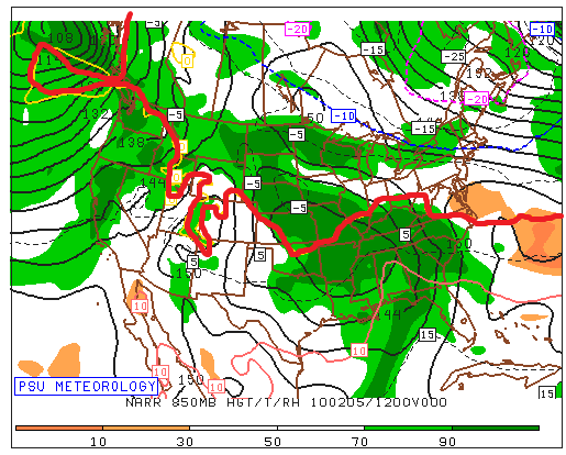
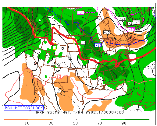
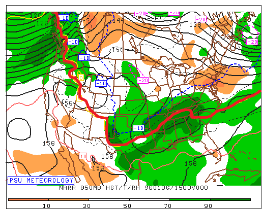
This kind of proves my point...that the temps are the most important issue...the thing I don't get is you act like its a given we will always have temp problems...NO its not...There are plenty of times we had a cold enough antecedent airmass in place that was....wait for it...5-10 degrees colder than the one forecasted this week. And that's why it snowed those times and why it might not this time for many places! Look at where the thermal boundary is at 850 and surface as the wave approaches Surface 850...and look where the REAL cold boundary is This is NOT what we want or need the thermals to look like as a wave begins its final approach...the WAA hasn't even kicked into high gear yet and were already too warm! We are left relying on everything else to be absolutely perfect to make up for the one main deficiency. Look at what we WANT the thermals to look like as a strong wave approaches us from the southwest...just so we can remember what COLD ENOUGH looked like, what we actually want the thermals to look like. January 1996 Ok maybe this isn't fair...it's one of our colder big storms and during a Nina. So here is a storm in another strong Nino during a very "warm" winter...at least by those days standards Feb 1983 And finally...Feb 2010 and at the time this was considered to be a marginal airmass! I remember about 5 days before that event I was discussing with Wes weather the airmass would be cold enough, he thought it was problematic and we were debating if with a perfect track it would be able to overcome the "questionable" airmass... so this was considered marginal and the bare minimum of what we need to be cold enough to snow Still miles better than what we have leading up to this event on guidance. So we could be super picky and analyze what we need from the SLP track and the upper low and the exact amplitude of the wave and the exact composition of the 50/50 and the western trough....but the one obvious flaw that makes it so that we need all that other crap to go 100% perfectly for us to get a big snow in DC is that its NOT COLD ENOUGH. BTW the reason I have been saying this a LOT lately is because its been true a lot lately and its why its not been snowing much the last 7 years. This is the least edgy controversial thing Ive ever said. Its a melba toast comment. Its like DUH. There is no mystery to why we haven't been snowing as much lately. THIS IS WHY...Temp anomalies Dec-Feb last 7 winters ITS THAT SIMPLE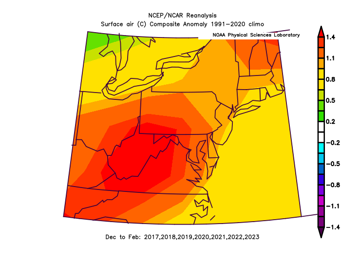
-
Jan Medium/Long Range Disco: Winter is coming
psuhoffman replied to stormtracker's topic in Mid Atlantic
I’m going to have to go into hiding if this happens. -
Jan Medium/Long Range Disco: Winter is coming
psuhoffman replied to stormtracker's topic in Mid Atlantic
There are plenty of storms where a colder antecedent airmass wouldn’t matter because the storm is likely to cut way west of us no matter what the temps in front are based on the flow. But more importantly when we actually do get snow (I know crazy thought) often there was a good enough antecedent airmass that another 5 degrees wouldn’t help. Might even hurt! Its just been so long…but our last snowy month January 2022, not the first wave as the cold arrived that was crazy and unusual…but the rest of the snow that month it was plenty cold. Maybe too cold! Maybe that one coastal bomb doesn’t miss us if it’s not so cold. And 5 degrees colder wouldn't have helped on the MLK weekend snow to rain event either. It was plenty cold. That’s why we got decent snow with an inside track. The issue was the primary cut due to where the upper low cut off and the trough axis. The mids were doomed regardless. But if you put the airmass we’re likely to have next week in front of that storm and places west of 95 that got a 2-4” snow likely get nothing from that same setup! A colder airmass gives us more wiggle room for all these variables to be less perfect and still snow. I know it seems like we never have that lately…and we haven’t…but guess what THATS WHY ITS NOT SNOWING. This isn’t some freaking mystery. The snow gods don’t hate us. We’re not just getting unlucky. It’s not snowing because it’s just not been cold enough 90% of the time recently! -
Jan Medium/Long Range Disco: Winter is coming
psuhoffman replied to stormtracker's topic in Mid Atlantic
I’m talking about the DC Baltimore area. You’re a whole different world. And i never said I ever thought it would be colder. I’m just saying if we wanted to make this setup much more likely to end up snowy for DC v just a possibility if a bunch of stuff breaks right…having a colder antecedent airmass if the one variable that would do that. That’s not even controversial. Im not even sure what you’re taking issue with. -
Jan Medium/Long Range Disco: Winter is coming
psuhoffman replied to stormtracker's topic in Mid Atlantic
I don’t know. But I know with the marginal thermal situation we need everything else to break near perfectly. 50/50 isn’t perfect rain. SW too amplified rain. Surface track inside at all…rain. I guess you can focus on all those variables but the one simple thing that would change all this in our favor would be if the airmass was maybe 5-10 degrees colder. -
Jan Medium/Long Range Disco: Winter is coming
psuhoffman replied to stormtracker's topic in Mid Atlantic
I think the biggest problem is the antecedent airmass just isn’t cold enough for a good but somewhat flawed setup to work. We could over analyze whatever little thing causes this or that. But systems will try to find the real thermal boundary. And the boundary with the best gradient is to our north. -
Jan Medium/Long Range Disco: Winter is coming
psuhoffman replied to stormtracker's topic in Mid Atlantic
The gefs is trending warmer also. -
Jan Medium/Long Range Disco: Winter is coming
psuhoffman replied to stormtracker's topic in Mid Atlantic
On the positive side if this goes sideways at least we won’t have to hear all the complaining when the snow gets washed away 2 days later by the cutter. -
Jan Medium/Long Range Disco: Winter is coming
psuhoffman replied to stormtracker's topic in Mid Atlantic
Technically the day 5 and 7 scores say it’s Euro, UKMET, CMC, GFS. Anecdotally the uk seems to struggle with east coast storms though. Doesn’t mean it’s wrong now though. -
Jan Medium/Long Range Disco: Winter is coming
psuhoffman replied to stormtracker's topic in Mid Atlantic
Omg the copium is out of control. Why do so many gravitate to one extreme or the other. There is either no trend and everything looks awesome because we should ignore anything that looks bad and just look at wherever still shows a good track. Or…it’s over these always trend north and this has no chance. Reality: The trend isn’t good, these do usually trend north, this isn’t where we ideally want to be, but they don’t always trend north. There are things that could reverse the trend. I’d say it’s 30/70 against us but that’s not hopeless and definitely still worth tracking. And obviously places further NW have a better chance than that here. Our best shot to reverse this would be for the 50/50 to trend more amplified and further SW. -
Jan Medium/Long Range Disco: Winter is coming
psuhoffman replied to stormtracker's topic in Mid Atlantic
You can go hunting for obscure data to support anything. Or you could loop the last 3 runs of the Euro, GFS and CMC and see a clear trend. It could turn around but we all know that’s not the most likely outcome. Why set yourself up for disappointment? If this is one of those 30% that things don’t trend north for some reason (we get lucky and the 50/50 goes ape or the NS phases in a better location) then we can be happy. But denying the clear trend and expecting the least probable outcome seems to just be setting us up for a bad bad meltdown. -
Jan Medium/Long Range Disco: Winter is coming
psuhoffman replied to stormtracker's topic in Mid Atlantic
CMC looks good NW of 95 but this is heading the wrong way at this range. We’re way too far out to already be fighting the R/S line. The bias isn’t as bad as it once was but in my experience more often things still trend slightly north on these the last 100 hours. -
Jan Medium/Long Range Disco: Winter is coming
psuhoffman replied to stormtracker's topic in Mid Atlantic
Time to plan my chase


