psuhoffman
-
Posts
26,411 -
Joined
-
Last visited
Content Type
Profiles
Blogs
Forums
American Weather
Media Demo
Store
Gallery
Everything posted by psuhoffman
-

Jan Medium/Long Range Disco: Winter is coming
psuhoffman replied to stormtracker's topic in Mid Atlantic
Not so subtle…definitely colder -
Jan Medium/Long Range Disco: Winter is coming
psuhoffman replied to stormtracker's topic in Mid Atlantic
Subtle but eps is slightly colder Saturday morning leading into the event. -
Jan Medium/Long Range Disco: Winter is coming
psuhoffman replied to stormtracker's topic in Mid Atlantic
That area should do very well. -
Jan Medium/Long Range Disco: Winter is coming
psuhoffman replied to stormtracker's topic in Mid Atlantic
I think the gefs is starting to cave in the long range. -
Jan Medium/Long Range Disco: Winter is coming
psuhoffman replied to stormtracker's topic in Mid Atlantic
-
Jan Medium/Long Range Disco: Winter is coming
psuhoffman replied to stormtracker's topic in Mid Atlantic
lol. We are not locking anything in. But I will say I’ve observed in the last few years since the major upgrades to the gfs and euro, there is a pattern where they start to narrow in on the general synoptic solution around 140-160 hours out. After that the changes are more subtle. We’re marginal so subtle could be big for our ground truth but once inside day 6 usually it’s not adjustments of 500 miles like it used to be. They even picked up on that crazy anafront wave from 5-6 days out! They still have limitations but since the last upgrade they seem to start identifying the basic idea a couple days earlier than before. I know we haven’t had many chances to test this locally but I’ve tracked storms for my various ski interests over the last few years. -
Jan Medium/Long Range Disco: Winter is coming
psuhoffman replied to stormtracker's topic in Mid Atlantic
The mids are fine at DC. Never gets close. But surface is 34-35 up 95 during the whole event. That’s not usually how this goes. Typically if anything the mid level warm later pushes further NW than the surface. If the euro is 2 degrees too warm at the surface this was a 12” snow in DC and Baltimore. I won’t say it. -
Jan Medium/Long Range Disco: Winter is coming
psuhoffman replied to stormtracker's topic in Mid Atlantic
I didn’t want to overstate it. I’ve make early observations then a run went sideways. But very early on it looked better over the top. Better confluence. Colder antecedent airmass. -
Jan Medium/Long Range Disco: Winter is coming
psuhoffman replied to stormtracker's topic in Mid Atlantic
Oh it’s COLDER leading in -
Jan Medium/Long Range Disco: Winter is coming
psuhoffman replied to stormtracker's topic in Mid Atlantic
I want to say I have a good feeling but don’t want to jinx it. Looks colder. -
Jan Medium/Long Range Disco: Winter is coming
psuhoffman replied to stormtracker's topic in Mid Atlantic
At 84 hours euro has slightly better confluence ahead of the wave than its 12z run. Still early though. -
Jan Medium/Long Range Disco: Winter is coming
psuhoffman replied to stormtracker's topic in Mid Atlantic
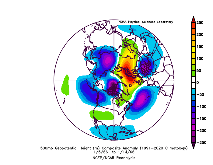
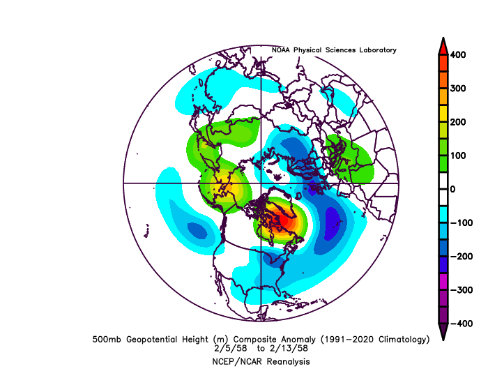
We are very likely going to get another jet extension mid January. That’s good! Yes it’s going to torch Canada. Also good, they’re very warm (by their standards) during almost all of our big Nino snow blitzes. It’s not December anymore. An extended jet in January has set up most of our Nino snowstorms! 2016 2010 1987 1983 1966 1958 I’m putting this here now because If we end up being too warm I don’t want to hear it’s because of the pacific jet. Yes the pac jet will extend and crash into the west coast. Yes it will flood Canada with pac puke. But with blocking and a split flow stj systems should slide under and in the past there was enough domestic cold to snow here. That’s the game plan. Not to have Canada be some icebox and advect that cold here. That’s not how we get big snow events in a Nino.

-
Jan Medium/Long Range Disco: Winter is coming
psuhoffman replied to stormtracker's topic in Mid Atlantic
GEPS went all in with the eps.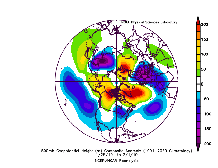
-
Jan Medium/Long Range Disco: Winter is coming
psuhoffman replied to stormtracker's topic in Mid Atlantic
The op gfs agrees with the eps pattern progression in the day 10-16 -
Jan Medium/Long Range Disco: Winter is coming
psuhoffman replied to stormtracker's topic in Mid Atlantic
Ggem progression is odd. Way less amplified SW but runs the surface system way out in front almost like a warm front. It’s a mess compared to all other guidance. -
Jan Medium/Long Range Disco: Winter is coming
psuhoffman replied to stormtracker's topic in Mid Atlantic
The SV doesn’t differentiate between ice and snow. It’s counting the freezing rain at 10-1. Doesn’t matter the Canadian thermals are ridiculous. Colder at the surface and a torch in the mids. -
Jan Medium/Long Range Disco: Winter is coming
psuhoffman replied to stormtracker's topic in Mid Atlantic
In a Nino we can go on a run fast if things line up. -
Jan Medium/Long Range Disco: Winter is coming
psuhoffman replied to stormtracker's topic in Mid Atlantic
Nope, can't think of anyone -
Jan Medium/Long Range Disco: Winter is coming
psuhoffman replied to stormtracker's topic in Mid Atlantic
The Germans are Fing with us -
Jan Medium/Long Range Disco: Winter is coming
psuhoffman replied to stormtracker's topic in Mid Atlantic
it always does that lol -
Jan Medium/Long Range Disco: Winter is coming
psuhoffman replied to stormtracker's topic in Mid Atlantic
It depends how things turn after the cutter on the 10th, which we still possibly could start as some frozen if we get lucky with the details. But after that there is a huge difference in how the EPS and GEFS progress the pattern with the GEPS somewhere in the middle. Neither is stacked immediately after although if the EPS is correct I definitely could see us getting some frozen from a progressive boundary wave in the 12-17th time period, although another cutter is possible if something phases and is too amplified. If the GEFS is right almost anything, even a progressive wave will cut well west of us in this time period. After that again depends on which guidance wins out...the EPS slowly shifts the trough southeast under the block as the pacific resumes a more nino look. Eventually by the 18th or so we could be chasing a big storm again. The GEFS on the other hand goes off the rails and the extended goes towards a full nina look and even flips the AO/NAO positive and frankly looks like 2020 and last winter by late January and implies winter is over after this Jan 7 storm. I do not think the GEFS is correct. The EPS matches my expected progression for the season so why would I favor the less accurate guidance that goes against history. But....I still will feel better when it caves! Thought it was in the process of caving yesterday then it reverted to full on disaster. I expect it will cave soon but I will do a shot in relief when that happens. -
Jan Medium/Long Range Disco: Winter is coming
psuhoffman replied to stormtracker's topic in Mid Atlantic
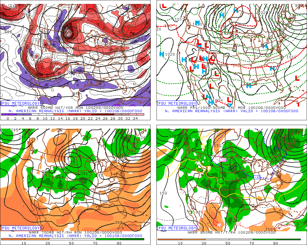
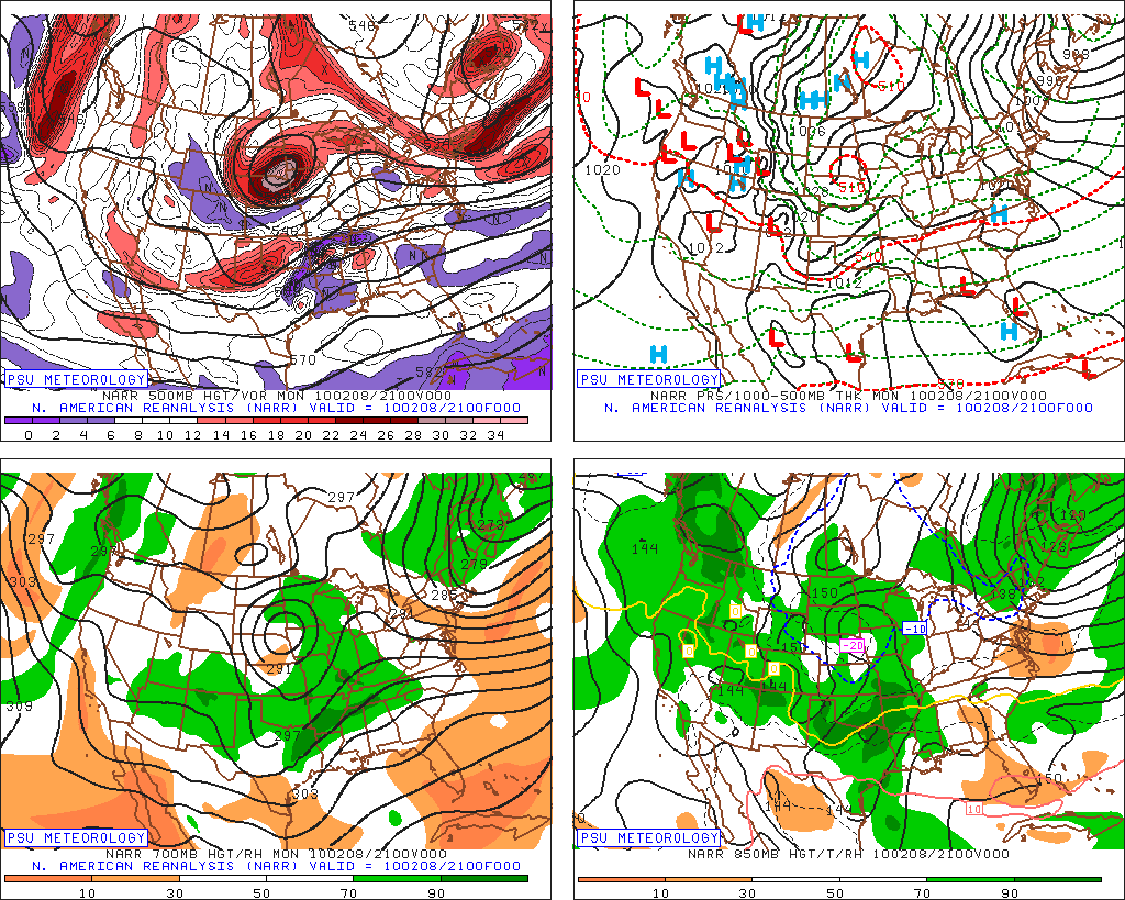
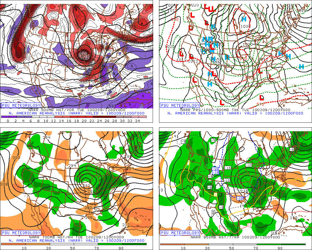
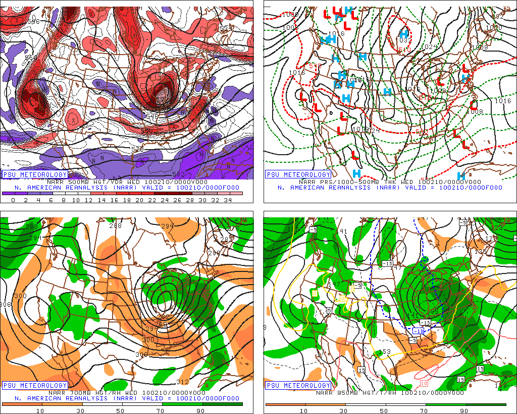
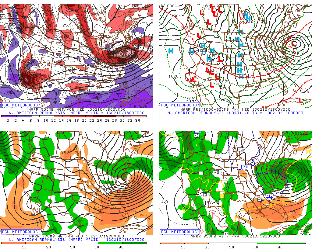
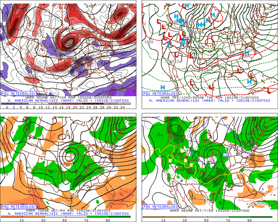
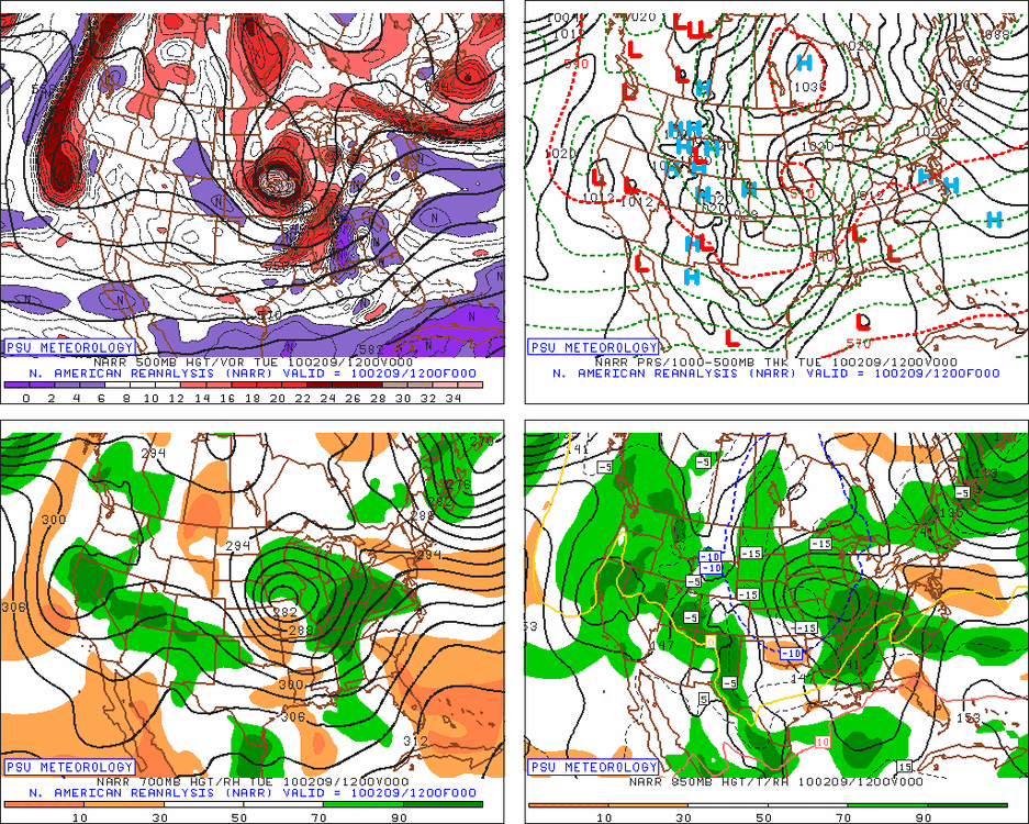
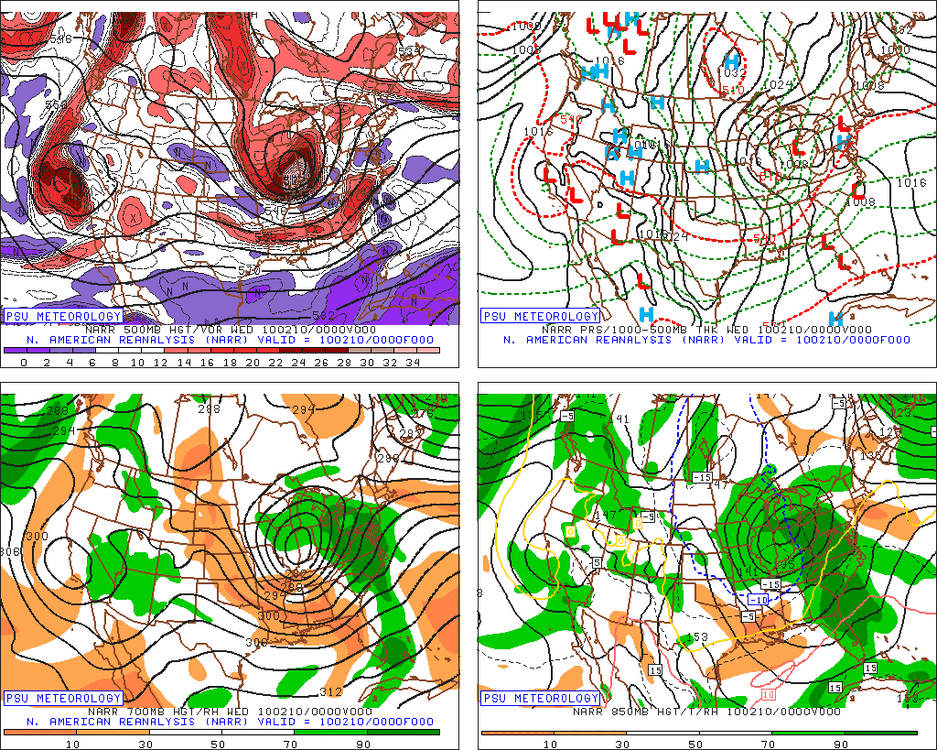
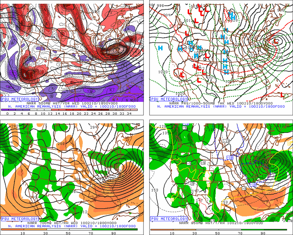
That was one of the oddest cases of any HECS storm for the mid atlantic. Initially there was a STJ system crossing the 4 corners as a stronger cut off system dove into the Dakotas out of Canada. They phased over the upper midwest and 99% of the time that would have been game over for us except we had maybe the most ridiculous block ever preventing anything from cutting and forced the closed upper low to continue southeastward. It did still have a STJ connection, there was a weak wave down in the gulf with a moisture feed up into the system but the dominant feature was always the NS system that dove due south out of Canada then turned southeast and continued southeast right across VA. I guess I would categorize it as a hybrid but it was as close to a NS miller b as any in that subset. That setup would never work again unless we had that kind of block. Some images from that system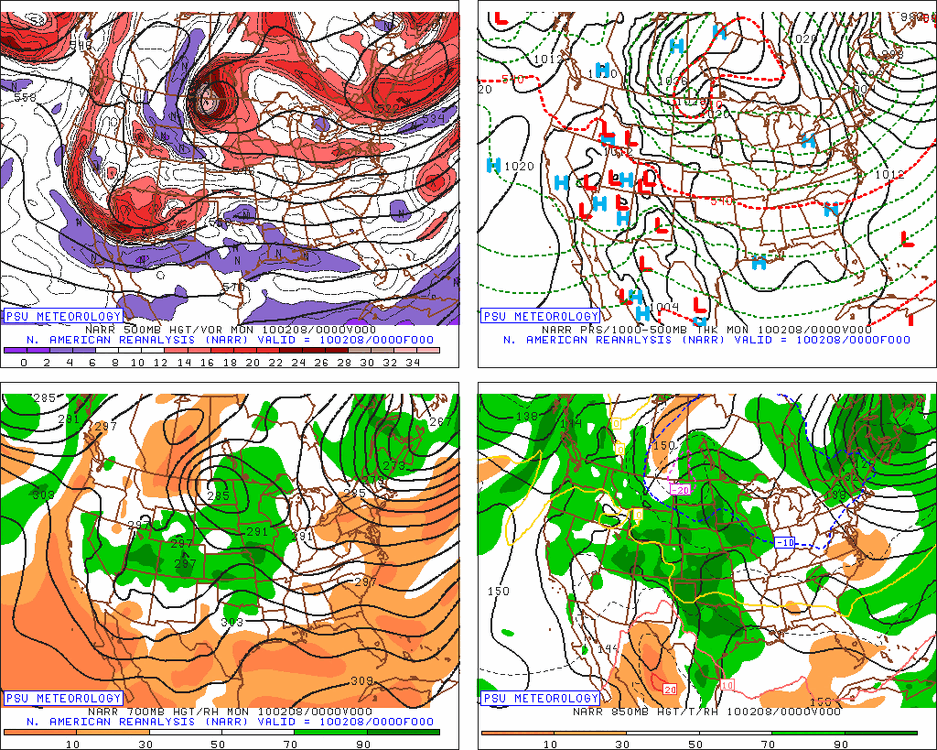
-
Jan Medium/Long Range Disco: Winter is coming
psuhoffman replied to stormtracker's topic in Mid Atlantic
Yes, there is a HUGE difference between a wave coming at us from the southwest tracking into the TN valley before transferring to a coastal and a northern stream SW diving out of the NW that develops a coastal storm. -
Jan Medium/Long Range Disco: Winter is coming
psuhoffman replied to stormtracker's topic in Mid Atlantic
We want the jet to extend enough to push the ridge back into western N America and establish a trough in the N Pacific. We just don't want it to go crazy like the last one. The reason we might get a relax and a cutter next week is because the jet retracts too much and we end up with nina like pacific forcing for a short time. -
Jan Medium/Long Range Disco: Winter is coming
psuhoffman replied to stormtracker's topic in Mid Atlantic
It’s sped up about 6 hours in the last 4 runs. this isn’t perfect but these frames are a better comparison when the storm is at a more similar spot in its pass which matters more. The change is noise imo. 18z looks slightly colder but with the 6 hour adjustment now it’s maybe an hour behind 0z so it’s a wash imo. The eps has been holding with only noise changes run to run today.