psuhoffman
-
Posts
26,411 -
Joined
-
Last visited
Content Type
Profiles
Blogs
Forums
American Weather
Media Demo
Store
Gallery
Everything posted by psuhoffman
-
About to find out but so far slightly better high pressure over the top. 1-2 mb stronger and anchored further west. Slightly weaker wave than previous euro stronger than gfs.
-
Out to 54 comparing to gfs. Slightly more confluence. Slightly weaker SW exiting the 4 corners.
-
I’m up but the SV peeps will be 5 mins ahead of me.
-

Jan Medium/Long Range Disco: Winter is coming
psuhoffman replied to stormtracker's topic in Mid Atlantic
Except pac jet extensions set up epic snow runs in some of the past Nino analogs. That pack looks fine. Should teleconnect to an eastern trough. Of course that was with a less torched pacific sst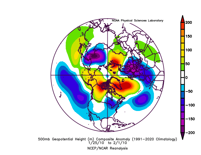
-
https://www.merriam-webster.com/dictionary/joke
-
If the Icon and NAM came out last instead of first no one would ever look at them. It’s trying to secondary in response to that second piece of NS energy catching up. Just got done

-
The goalposts have been pretty narrow for day 5-7. It’s been shifting around but if you zoom out the idea wrt track and a snow event somewhere in the mid atl to northeast has been there. But we care a lot about what are the finer details that determine a 50 mile shift in the R/Sn. It wasn’t that long ago that a whole synoptic event track would shift hundreds of miles at this range run to run. I guess it’s all perspective and perception how you define this though.
-
Jan Medium/Long Range Disco: Winter is coming
psuhoffman replied to stormtracker's topic in Mid Atlantic
I’m going to start specifying the parts of my posts you aren’t allowed to read. Here I fixed it for you. Try this again. -
The ggem often plays follow the leader when it jumps around but att it does seem like maybe it’s actually leading the trends. Who knows. The delicate power play between all those western SWs is driving the guidance (and us) crazy. This is cool. Enjoy it. But until the details with those features stops shifting around every 12 hours don’t get too comfortable with any one specific projection. The general pattern idea has been there since day 15! The general synoptic look since day 7-8. Amazing with all the crap going on in the jet out west. But we need to finer details to get nailed down since we’re on a razors edge wrt thermals.
-
I forgot how exhausting this is.
-
Jan Medium/Long Range Disco: Winter is coming
psuhoffman replied to stormtracker's topic in Mid Atlantic
No it’s a Nino. I want all the snow! Now. Later. Later when it’s now and now when it’s later. I want to steal Docs DeLorean so I can experience the now and later snow at the same damn time. -
F$&! I was kinda looking forwards to a good nights sleep
-
Guess I need to go look at the gfs
-
Jan Medium/Long Range Disco: Winter is coming
psuhoffman replied to stormtracker's topic in Mid Atlantic
Agreed but there should be blue! Yea it’s a trough. Ugh never mind. I think we will be fine. -
Jan Medium/Long Range Disco: Winter is coming
psuhoffman replied to stormtracker's topic in Mid Atlantic
You skip right to the negative of every post -
Jan Medium/Long Range Disco: Winter is coming
psuhoffman replied to stormtracker's topic in Mid Atlantic
this was never a super cold pattern. Yea our dominant flow is out if the NW and there is some arctic influence. But the main flow into Canada is off the pacific. Historically it’s cold enough though. But what happens if you keep warming the pacific? At some point does that equation just not work anymore? I’m just speculating. My guess is this is missing the trough. Washing it out with warmer members. But we might be headed eventually to a point where the pac is too warm for this to work. If that doesn’t work anymore then we’re left needing some epo pna ridge combo which is extremely rare. We got that in 2014. For a few weeks in Jan 2022. But that’s never been the most common path to our snow. Worse it’s not even a big snowstorm pattern it would be progressive because you usually cant have a block with that kind of full latitude epo pna ridge. I dont think we’re there yet. But if the pac keeps warming eventually that might become the reality. -
Devils advocate…didn’t those of us that have played this game long enough kinda know deep down in our gut that we were playing with fire seeing those marginal temps and that our area being on the southern edge of the consensus snow at 150 hours was not ideal? Come on admit it…almost every major snow event from 100-150 were either in the bullseye or the northern edge of the snow. That’s why the “fringed” joke with me. We want me to be fringed at 120 hours? If I’m worried about mixing at day 6 we’re not in a great spot! I hinted at that but I didn’t want to be the Deb so I mostly stayed quiet. Things can trend to snow from day 5. And it’s possible we still get a decent event if this new evolution trends our way. But the truth is even if guidance didn’t show a big hit day 6 we would probably see the signs it could trend that way and we wouldn’t be caught surprised. Think back to Dec 2009. It wasn’t on guidance like that from 7 days but we saw the potential and were tracking it and knew it has a good chance to trend into that! We knew inside this wasn’t a great look at day 6 to get a big snow and we probably would identify a threat that wasn’t looking big verbatim but had the potential to trend better also! We’ve become very pretty good at this game in this sub I think.
-
Jan Medium/Long Range Disco: Winter is coming
psuhoffman replied to stormtracker's topic in Mid Atlantic
Since I know how some react to any non rainbow and unicorns analytical statement I make let me be clear I am very optimistic we will be fine. This is just speculative. The old gefs looks didn’t bother me too much. Yea I didn’t love anything looking that way but I was 90% sure it was out to lunch. This though…is slightly and I mean only slightly troubling. Look at the pac pattern the last week of Jan. 1 should produce a trough at 2! But it’s not. That’s been consistent on the euro for a while. We get the pacific we want but… I think that’s wrong too. And yea I know by Feb 7 it starts showing a trough. But it keeps pushing that back. Not the pacific but the downstream effects. Not much blue anywhere on that map though outside the Nino n pac low. -
Jan Medium/Long Range Disco: Winter is coming
psuhoffman replied to stormtracker's topic in Mid Atlantic
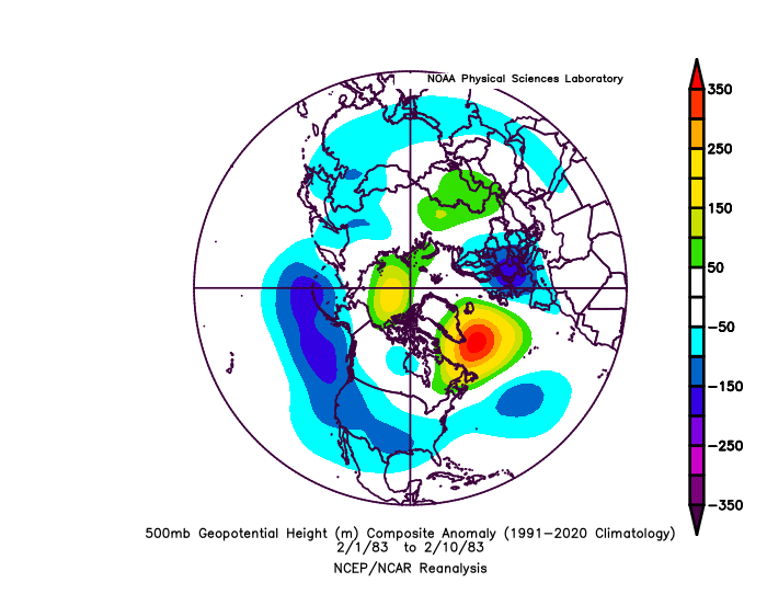
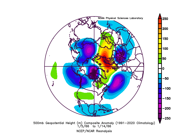
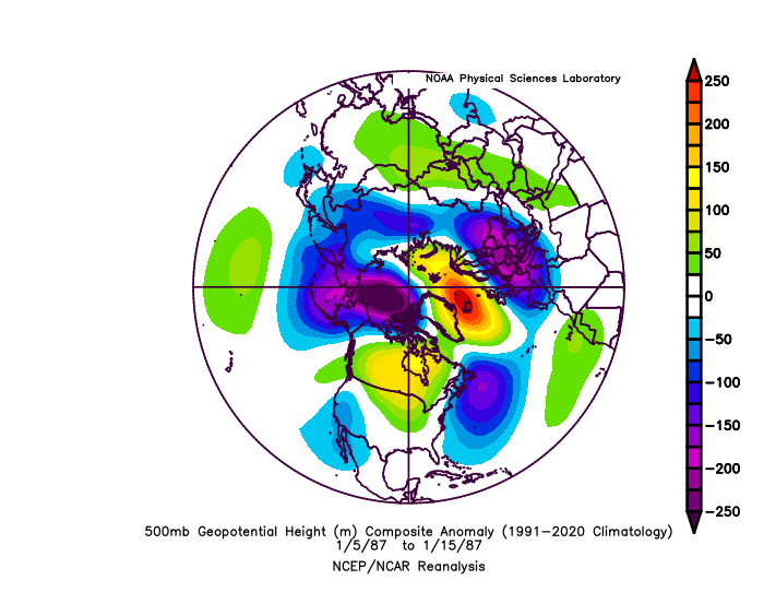
Hence my question. It’s pertinent because 1966 was one of my top 3 analogs and if I had to re rank now based on how the season has progressed it would be number 1. So this might be where we’re heading. I just want to get him on the record in a definitive way. I feel like he hints but never comes out and says it. And Im not saying he would be wrong. We might find out. I’ve said this year is a good test case. -
Jan Medium/Long Range Disco: Winter is coming
psuhoffman replied to stormtracker's topic in Mid Atlantic
@Stormchaserchuck1…this produced 3 snow events and one of our epic Nino snow runs. -pna. I think this is where we’re headed. Yes or no, are you saying this wouldn’t work anymore?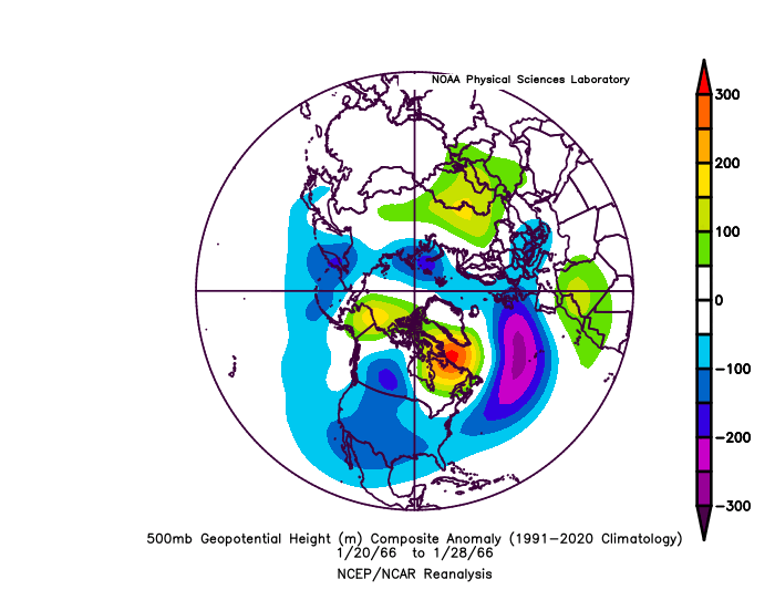
-
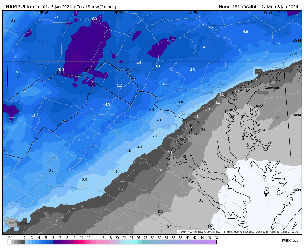
1z updated on wxbell. Another slow decline unfortunately. Not sure what caused it. 18z data was slightly better I thought then 12z. But it is what it is. Still would be a decent way to get on the board for many.

-
I drove from N. VA to PSU in a few snowstorms. Made the trip during the tail end of the PD2 storm! They generally take care of the roads. By Sunday should be ok. If it’s iffy at all take 70 to 99 instead of 15 to 322. Now that 99 is finished that might be faster now anyways. Back in my day the quicker route was 322 from Harrisburg but that can get dicier in snow.
-
A lot of gfs like solutions in there
-
Forgive me but given the last few years and your MO at first glance I thought it said I think 18z euro would have been a torch As of right now I don’t think anything is “trending” per se. guidance picked up on a major shift due to that western SW. euro at 6z. Gfs at 12z. Oddly the ggem had this first then reverted to what other guidance had yesterday. But other than catching on to the trend towards stronger trailing SW that dampens our SW they aren’t trending just settling into the new paradigm. on a side note the ggem does this a lot. Will have an idea then just when everything else trends towards it…it goes off on a tangent. I know it scores better than tie gfs but anecdotally it seems less reliable.
-
Gettysburg is a perfect town to be in the snow! Do you know is that little cider micro brew still there on the main square? Lots of places like that didn’t survive Covid unfortunately.