uofmiami
-
Posts
1,972 -
Joined
-
Last visited
Content Type
Profiles
Blogs
Forums
American Weather
Media Demo
Store
Gallery
Everything posted by uofmiami
-
92 at both my stations for today.
-
Park didn't hit 90 on Wednesday, only got to 87. Have to wait for tomorrow. CLIMATE REPORT NATIONAL WEATHER SERVICE NEW YORK, NY217 AM EDT THU JUL 27 2023......................................THE CENTRAL PARK NY CLIMATE SUMMARY FOR JULY 26 2023...CLIMATE NORMAL PERIOD 1991 TO 2020CLIMATE RECORD PERIOD 1869 TO 2023WEATHER ITEM OBSERVED TIME RECORD YEAR NORMAL DEPARTURE LAST VALUE (LST) VALUE VALUE FROM YEAR NORMAL ...................................................................TEMPERATURE (F) YESTERDAY MAXIMUM 87 346 PM 98 1940 85 2 81
-
Skunked at my stations. .15 for Muttontown & .08 in Syosset.
-
A rarity for sure, thanks to the S wind. Helps being a little further N to get the higher temp, but it's disgusting out regardless.
-
93 (92.5) for Syosset & 92 (92.4) for Muttontown for the high.
-
91 at both my stations now: 91/70/98 in Muttontown & 91/78/107 in Syosset
-
Currently 90 at both my stations.
-
Need a nice W wind on top of the heat dome, looks like we are going to get SW winds with possible storms. That’s not going to cut it for big heat, at least along the coast. Maybe mid August we get one more chance for big heat this summer. It’ll be brutal regardless with DPs of mid 70s and temp in the low 90s.
-
Muttontown is 6 90+ to date & Syosset is 2. 3 of those days were 89.5 to 89.9 in Muttontown. 87.3 in Muttontown & 87.2 in Syosset for today.
-
Yep I had my U of Miami get together that weekend for incoming fall students in the NY area, was 101 on the car temp driving back on LI.
-
https://www.spc.noaa.gov/products/watch/ww0546.html URGENT - IMMEDIATE BROADCAST REQUESTED Severe Thunderstorm Watch Number 546 NWS Storm Prediction Center Norman OK 1210 PM EDT Tue Jul 25 2023 The NWS Storm Prediction Center has issued a * Severe Thunderstorm Watch for portions of Connecticut District Of Columbia Delaware Eastern Maryland New Jersey Southeast New York Eastern Pennsylvania Northern Virginia Coastal Waters * Effective this Tuesday afternoon and evening from 1210 PM until 800 PM EDT. * Primary threats include... Scattered damaging wind gusts to 70 mph possible Isolated large hail events to 1.5 inches in diameter possible
-
-
Can you fly him to Texas on your next flight?
-
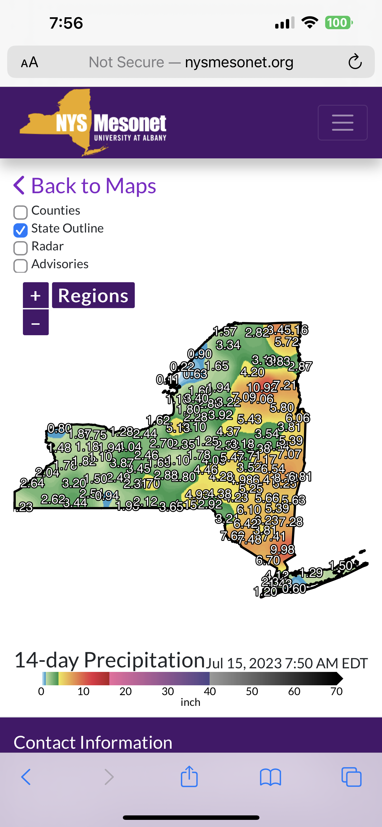
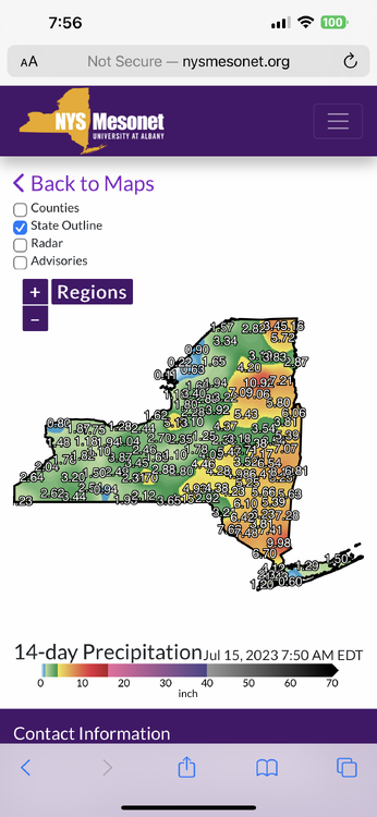
Muttontown has .84 already
-
Already is one for S Nassau
-
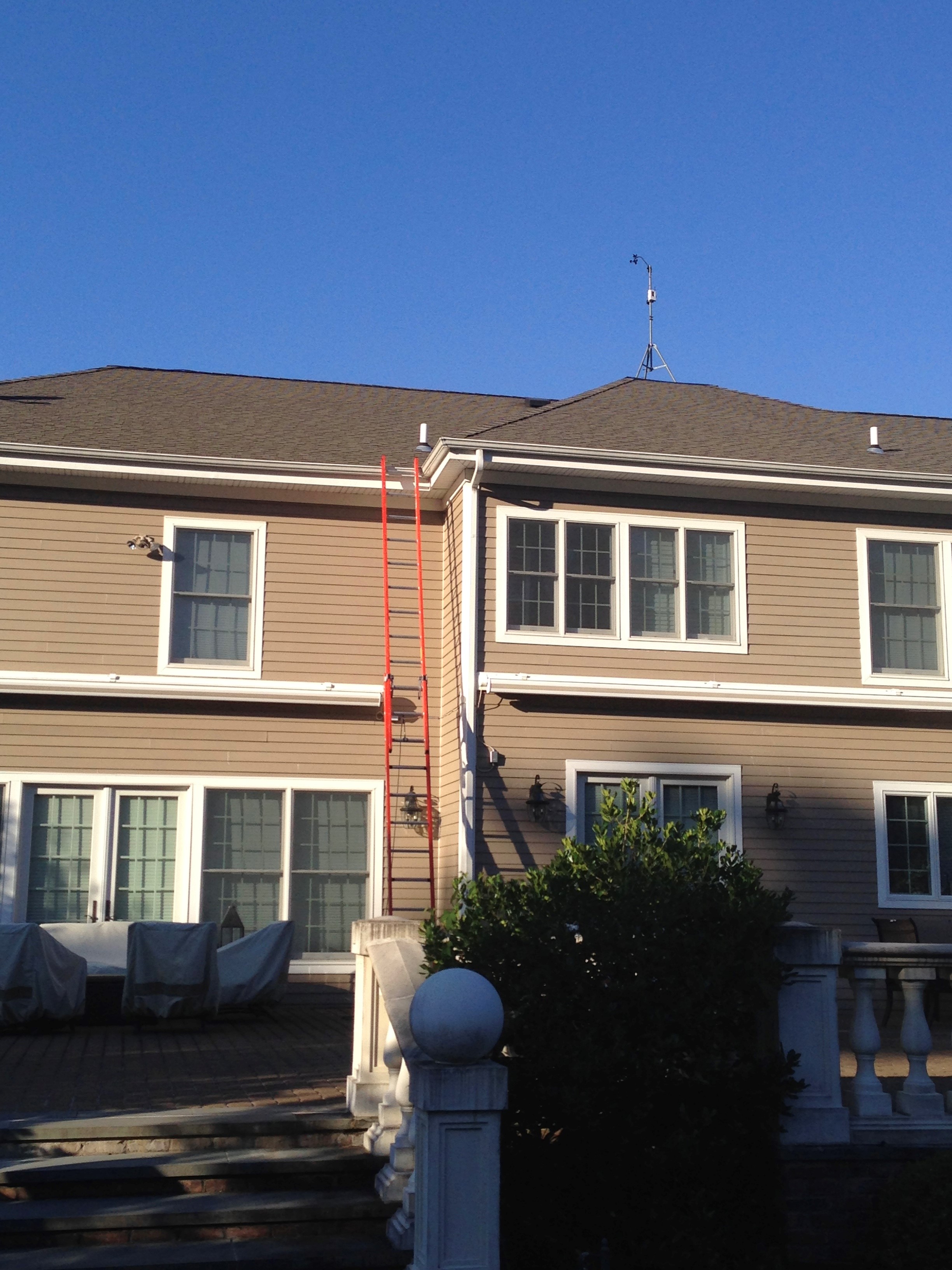
Thank you. Yes, when I was younger and didn't have kids. Setup the orientation, etc. down on the ground and carried the tripod with anemometer attached up on the ladder to the roof & installed. Over the years had to go back up to replace failed anemometer & replace transmitter battery.
-
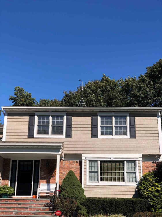
You can do the tripod mount on the roof with transmitter, so the anemometer is 6' off the roof line, though some don't like drilling into their roof. Regardless, just make sure you have it grounded by an electrician so insurance doesn't deny any claim should something happen from lightning. May want to ask a contractor or roofer if they can install pole with equipment attached. Here are pictures of the anemometers on my two stations installed on the roof. Muttontown: Syosset:

-
Have to wait until this weekend, Sunday, for a brief drop of the DPs into the 50s. Might get a brief drop on Wed too, all short lived though.
-
All the way to Maine it seems, impressive!
-
.82 so far in Syosset & .35 in Muttontown.
-
He’s under water
-
-
-
Nassau County, oh yeah!!!!