uofmiami
-
Posts
1,972 -
Joined
-
Last visited
Content Type
Profiles
Blogs
Forums
American Weather
Media Demo
Store
Gallery
Everything posted by uofmiami
-
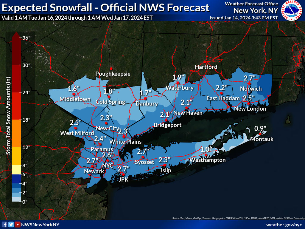
Light snow in Syosset
-
-
If there’s a positive NAO, no muting that pac air. Dr Lee doesn’t seem optimistic a negative NAO comes from this strat disruption.
-
Temp crashed, down to 28 in Muttontown & 29 in Syosset.
-
County plow removing any slush from the county maintained road outside my office. I'm sure they'll salt afterwards & road should be good.
-
Winds now NW and temp down to 31.3 in Syosset. 31.7 was the high. Roads are wet and fine on drive to Great Neck.
-
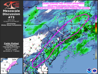
https://www.spc.noaa.gov/products/md/md0073.html Mesoscale Discussion 0073 NWS Storm Prediction Center Norman OK 0749 AM CST Tue Jan 16 2024 Areas affected...Parts of the Mid Atlantic into southern New England Concerning...Winter mixed precipitation Valid 161349Z - 161745Z SUMMARY...Locally moderate winter precipitation rates will spread northeastward this morning, with some modest ice accretion possible where freezing rain persists. DISCUSSION...A surface low currently off of the Mid Atlantic coast is forecast to gradually deepen as it moves northeast toward coastal southern New England this morning. Multiple waves of light to locally moderate precipitation are ongoing and will continue to spread northeastward in conjunction with the surface low. While interior portions of the Northeast will likely continue to see snow (with generally light to moderate rates) this morning, low-level warm advection will support a transition from snow to sleet across parts of southern New England, with freezing rain persisting over portions of the Mid Atlantic region. As the low deepens offshore, a modest uptick in precipitation intensity will be possible through the morning. While rates will likely remain light to locally moderate, antecedent cold conditions (with temperatures initially in the 20s F) may result in relatively efficient ice accretion in areas that transition to freezing rain. Pockets of moderate sleet/snow will also be possible into parts of southern New England. Low-level warm advection will support a gradual transition to rain along the Mid Atlantic and southern New England coasts, but subfreezing temperatures may persist inland through the morning.
-
2” here in N Syosset sent to OKX. 28 & snowing currently.
-
I’m sure they’ll get 3”. I wouldn’t worry about being under the advisory really. We are getting measurable snow & it’s long overdue.
-
Extended summer stormlover74 future snow hole banter thread 23
uofmiami replied to BxEngine's topic in New York City Metro
I had Foxboro to see the Pats/Jets back in 1991. Uncle had season ticket for Pats. Low 30s and windy as hell. Couldn’t feel my feet/hands and ass was frozen from metal bleachers at that stadium. Good times as a teenager. -
1.55” for the storm with peak gust of 33mph.
-
5 days out I’d be skeptical of all guidance. Let’s get this next storm out of the way and hopefully by 12Z Saturday runs there’s consensus as to what to expect for Tuesday.
-
Saw a tree with severe rot in the trunk split in two on way to work in someone's front yard in Oyster Bay Cove. Otherwise, I think most of the dead wood, etc fell in prior Dec storms.